
SPRING/2023 DESTINATION PEMBERTON GOING FOR GOLD PROSPECTING 101 BCMAG.CA
DITCH THE LAWN, GROW VEGGIES GO NORTH MUSKWA-KECHIKA ON HORSEBACK & THE NORTHERN WONDERS OF HIGHWAY 37
URBAN GARDENING
Tā
Provincial Park
Boya Lake,
Ch'ilā
The historic River Ranch 3,933 acres, 39 titles, 17 km frontage on Nechako River, 2 houses, office, accommodation buildings, conference hall, 44 room unfinished hotel, off-grid with solar and generators, airstrip. Barn, corrals, 1,200± acres of hay and grassland, Range Permit rights. Wildlife. $4,995,000


RICHARD OSBORNE
Personal Real Estate Corporation
604-328-0848 rich@landquest.com
Located just minutes from town center the nicely treed lots are located just as Stuart Lake becomes Stuart River. Build three residences or just keep a couple lots for an investment. Hydro, gas and Internet is available all along paved Sweder Road. Country Life at its finest. $295,000
KURT NIELSEN 250-898-7200 kurt @landquest.com
FORESTED ACREAGE WITH MULTIPLE DWELLINGS & SUBDIVISION POTENTIAL - SCOTCH CREEK, BC

Beautiful acreage (162 acres) in the North Shuswap with loads of potential. Zoning allows for 10 acre lots. Significant timber value. Extensive improvements including multiple homes and cabins, large shops (plural!). Off-grid services with BC Hydro nearby for connection if desired. $1,550,000
MATT CAMERON 250-200-1199 matt @landquest.com
THE HAVEN - A TRANSFORMATIONAL LEARNING CENTRE - GABRIOLA ISLAND


6.77 acres with 426± ft of low bank walk-on oceanfront. The 16 buildings accommodate up to 120 guests. Long established not-for-profit centre for transformational learning can be enriched and expanded or transformed into a resort, private residence, or your vision. NOW $5,200,000
JASON ZROBACK 1-604-414-5577 jason @landquest.com
JAMIE ZROBACK 1-604-483-1605 jamie @landquest.com
Quiet and private view acreage at the south end of Galiano with two off-grid cabins and spectacular ocean and mountain views. Seasonal creek, large mature timber, and several meadows. Drilled well and driveway in place. Priced to Sell at $595,000

DAVE SIMONE 250-539-8733 DS @landquest.com
FAMILY HOME AND HOBBY
Stunning views from this very well maintained 24.76 acre hobby farm in the Bella Coola Valley. The picturesque property is perfect for a small hobby farm. It is complete with numerous outbuildings, raised garden beds, fruit trees, established berry bushes, electric fencing, river access and more! $595,000

FAWN GUNDERSON
Personal Real Estate Corporation 250-982-2314 fawn @landquest.com
THE RANCHES AT ELK PARK CLIFFSIDE RANCH - RADIUM HOT SPRINGS, BC

Picturesque acreage (230 acres) at the foot of the Rocky Mountains in the Prestigious Elk Park Ranch. The most quintessential Columbia Valley views imaginable. Micro hydro system serving a greenhouse structure with a residential suite. Fully forested with established trails throughout. $1,899,000
MATT CAMERON 250-200-1199 matt @landquest.com
FISHIN’ HUNTIN’ AND LOVIN’ EVERY DAY NECHAKO LODGE - KNEWSTUBB LAKE, BC
The Nechako Lodge has six guest rooms, a commercial kitchen and large gathering area. There is also a two bedroom residence, four cabins and six RV sites. Solar and wind power the property. Includes a foreshore lease with docks, breakwater and boat launch. $795,000


JOHN ARMSTRONG
Personal Real Estate Corporation 250-307-2100 john @landquest.com


Pristine south-facing waterfront home on Lake Cowichan with 90+ ft of gentle sloping beach frontage. 2,100 sf home with large windows throughout offering views from every room of the house. 10 x 20 ft landing, 54 ft aluminum ramp leading to a new 10 x 24 ft private dock. Sit around the fire pit on the pebbled beach and enjoy the peaceful tranquility of the lake. $2,250,000
KEVIN KITTMER 250-951-8631 kevin@landquest.com
7,117 ACRE CONTIGUOUS FARM OPERATION IN THE HEART OF BC’S PEACE RIVER REGION - FORT ST. JOHN, BC


Contiguous 7,117.57 acre farm in the Altona area of BC’s Peace River region. This immaculate farm offers 9 km of river frontage on the Beaton River. Possesses rich soil and fertile growing conditions. The current farm tenants grow a variety of crops including fescue, canola, barley, peas and oats. Production information is available upon request. Approximately 4,613 acres are in cleared production with the production land situated in a cohesive block. The farm derives $11,700 per annum in oil / gas revenues. These facilities are unobtrusive in nature. There are 16 separate titles and approximately 10 grain bins. Various creeks and dugouts are located throughout the farm. The remainder of the property is timbered, but there could be additional lands cleared and put into production. $6,500,000
FAWN GUNDERSON
Personal Real Estate Corporation 250-982-2314 fawn @landquest.com
NAKISKA RANCH WELLS GRAY PARK - CLEARWATER, BC
472 acre guest ranch that generates great income. Main house / lodge to live in, along with many outbuildings for ranch operation. Cabins & lodge accommodation are booked solid from May to October. 300 acres of timber & 170 acres in hay, generating about 600 round bales. Can support about 50 cow - calf pairs. 29 km from Clearwater in Wells Gray Park. $2,999,000
ROB GREENE 604-830-2020 rob @landquest.com
LAKEFRONT EQUESTRIAN ESTATE LAC LA HACHE, BC
This estate ranch is a 29.78-acre world class lakefront equestrian estate. Accommodations are 3 custom log homes, 2 custom log cabins and 8 serviced RV sites situated on 1,400 ft of unobstructed lakeshore on beautiful Lac La Hache. $4,100,000
JOHN ARMSTRONG
Personal Real Estate Corporation
250-307-2100 john @landquest.com

® Marketing British Columbia to the World® www.landquest.com Toll Free 1-866-558-LAND (5263) Phone 604-664-7630 Visit Us Stunning views from this very well maintained 24.76 acre hobby farm in the Bella Coola Valley. The picturesque property is perfect for a small hobby farm. It is complete with numerous outbuildings, raised garden beds, fruit trees, established berry bushes, electric fencing, river access and more! $595,000 LARGE, NEWLY RENOVATED FAMILY HOME WITH SHOP - HAGENSBORG / BELLA COOLA, BC Sam Hodson Personal Real Estate Corporation 604-809-2616 sam @landaquest.com 317 acres 20 minutes from Prince George. 85 acres hay land. 2 km riverfrontage on scenic Chilako River. Includes main house with 4 bedrooms, 1 bath and second home with 3 bedrooms and 1 bath. 32 x 22 ft shop with cement floors and 200 amp power. Storage sheds, workshop, hay shed and 2 loafing sheds. Some timber. $1,179,000 AFFORDABLE STARTER RANCH CLOSE TO TOWN PRINCE GEORGE, BC CHASE WESTERSUND - WESTERN LAND GROUP Personal Real Estate Corporation 778-927-6634 chase @landquest.com COLE WESTERSUND - WESTERN LAND GROUP Personal Real Estate Corporation 604-360-0793 cole @landquest.com
FARM BELLA COOLA, BC
5.4 ACRES IN 3 TITLES LEVEL FORT ST. JAMES RIVERFRONT
LAKE COWICHAN WATERFRONT YOUBOU, BC
10 ACRE OCEAN VIEW WILDERNESS PROPERTY GALIANO ISLAND
THE HISTORIC RIVER RANCH VANDERHOOF, BC


BC MAG • 3 Contents 24 BC & the Art of Motorcycle Maintenance Renting a motorbike to explore the province, a nervous writer becomes an easy rider 32 Archie’s Guide to Highway 37 Experiencing the wonders of BC’s North 44 The Muskwa Kechika: Land of Legacy Cowboy dreams fulfilled in this two-week trek through the “Serengeti of the North” 52 Going for Gold
beginner’s guide to a time-honoured BC tradition—gold prospecting 60 Urban Gardening
rising food bills and concerns over scarcity, the time has never been better to explore your green thumb 68 Redefining Small-Town BC
new rec-tech summit reimagines how we live, work and play in resource and tourism-dependent rural communities 4 Editor’s Note 6 Mailbox 8 Due West 16 Destination Pemberton 74 Backyard Getaways Fort Langley 82 BC Confessions Burial at Sea IN EVERY ISSUE Cover Photo Destination BC/Andrew Strain VOLUME 65 - ISSUE 01 SPRING 52 Tā Ch'ilā Provincial Park 16 68 74 32 44 FEATURES
A
With
A
SPRING
Gold Fever
THE LURE OF GOLD is one of British Columbia’s most enduring and romantic notions. Ever since the Gold Rush in the mid 19th century, fortune seekers the world over have travelled here to search our waterways and rock formations for this lustrous metal. What was once a life-changing gamble 150 years ago has turned into a profession occupied by mining companies, private claim owners and social-media prospectors, as well as a hobby for people with a gambler’s heart and a love of the outdoors.
I fall firmly into the latter category. As I’ve talked about in these pages before, I’m always up for a little “hiking with a purpose,” whether that’s fly fishing, rock hounding and, most recently, panning for gold—all at the most amateur of skill levels, of course. Just as Linda Gabris describes in her story “Going for Gold” on page 52, I too caught my gold fever at the gold panning display during a road trip to the historic mining town of Barkerville. After watching my kids find little gold flakes in their pay dirt, I was inspired to purchase one of the Barkerville-branded gold pans they have available in the gift shop—thinking that this was going to be my new hobby.
After several years with that gold pan sitting untouched in my closet, I finally gave it a go during the depths of Covid isolation at a little stream by our family cabin on Vancouver Island. I had read in one of Rick Hudson’s articles on rock hounding that gold was found just upstream from the road crossing near us, and surely the expertise I gained from watching my kids pan for gold one time would lead me to riches on the
riverbank. That wasn’t even remotely the case, but it did provide us with a fun afternoon of scooping up gravel and washing it in the pan in the creek.
Just like my no-catch fly fishing outings, I’m not one to let bad luck stop me from enjoying a hobby. In fact, soon after this expedition I purchased a high-powered magnet to go magnet fishing off the dock (a little more success here, as I pulled a rusty log boom spike from a lake), and eventually purchased a metal-detector “for my son,” which has found us a pile of rusty nails and aluminum cans.
This past summer, BC Magazine art director Arran Yates and I took a backcountry road trip on the Hurley Forest Service Road from Pemberton to Gold Bridge, with half an idea to try all this stuff out. We had a great time crawling around the old, abandoned mining equipment and tailings, and imagining ourselves living in the Bridge River Valley all those years ago. Of course, we had no luck finding anything of note with the gear, but I did get a consolation prize of grabbing some nice pieces of nephrite jade to take home as treasure.
That road trip is simply amazing, and we have plans to do it again this summer with hopes of striking rich. Though this time we’re going prepared with a little more knowledge, both from Linda’s great article in this issue and by watching Aussie Gold Hunters online. But as the saying goes, the chase is better than the catch, so I’m sure we’ll have a blast even if we strike out.
—Dale Miller
EDITOR Dale Miller editor@bcmag.ca
ART DIRECTOR
Arran Yates
ASSISTANT EDITOR Blaine Willick
ASSOCIATE EDITOR Sam Burkhart

GENERAL ADVERTISING INQUIRIES 604-428-0259

ACCOUNT MANAGER Tyrone Stelzenmuller 604-620-0031
ACCOUNT MANAGER (VAN. ISLE) Kathy Moore 250-748-6416
ACCOUNT MANAGER Meena Mann 604-559-9052
ACCOUNT MANAGER Katherine Kjaer 250-592-5331
PUBLISHER / PRESIDENT Mark Yelic MARKETING MANAGER Desiree Miller
GROUP CONTROLLER Anthea Williams
ACCOUNTING Angie Danis, Elizabeth Williams
DIRECTOR - CONSUMER MARKETING Craig Sweetman CIRCULATION & CUSTOMER SERVICE Roxanne Davies, Lauren McCabe, Marissa Miller
SUBSCRIPTION HOTLINE 1-800-663-7611
SUBSCRIBER
cs@bcmag.ca

4 • BC MAG
ENQUIRIES:
SUBSCRIPTION RATES FREE with your subscription: the British Columbia Magazine wall calendar. 13 months of glorious landscape and wildlife photography. 1 year (four issues): $19.95 / 2 years: $34.95 / 3 years: $46.95 Add $6 for Canadian, $10 for U.S., or $12 for International subscriptions per year for P&H. Newsstand single-issue cover price: $8.95 plus tax. Send Name & Address Along With Payment To: British Columbia Magazine, 802-1166 Alberni St. Vancouver, BC, V6E 3Z3 Canada British Columbia Magazine is published four times per year: Spring (March), Summer (June), Fall (September), Winter (December) Contents copyright 2022 by British Columbia Magazine. All rights reserved. Reproduction of any article, photograph or artwork without written permission is strictly forbidden. The publisher can assume no responsibility for unsolicited material.
1709-4623 802-1166 Alberni Street Vancouver, BC, Canada V6E 3Z3 PRINTED IN CANADA Canadian Publications Mail Product Sales Agreement No. 40069119. Return undeliverable Canadian addresses to Circulation Dept., 802-1166 Alberni Street, Vancouver, BC, Canada V6E 3Z3. Tel: (604) 428-0259 Fax: (604) 620-0245 WWW.BCMAG.CA
ISSN
EDITOR’S NOTE


ROAD TRIPS WWW.BCMAG.CA/ROADGUIDE 1.800.663.7611 AVAILABLE THIS SPRING ORDER ONLINE HIGHLIGHTS INCLUDE Winery & Cidery Tours / Craft Breweries / BC Pit Stops / Iconic Destinations Hidden Gems / Cross-Border Trips / Detailed Maps & Drive Times / and lots more! VOLUME 5 - COMING SOON
Mailbox
Buy it here
BOWRON LAKES
The article on Bowron Lakes in the Fall 2022 issue could not have been better timed, as last week I gave a talk to my Rotary Club in Wales on our canoe trip around the Bowron Lake chain in early September 1967. Paul Lyons and I rented a timber canoe and drove up from Vancouver. We set off after a brief chat with Davy the park ranger, who mentioned grizzly bears and the fact that he did a weekly circuit around the chain in the event we were stranded! We were there in the first week in September and on day two it snowed (a bit different to the 30 degrees mentioned in the article). When we got to Lanezi Lake, the trapper’s cabin was occupied, so we camped next door and dried our saturated sleeping bags by the wood stove. The two Canadians who were there shared a couple of Kamloops trout (a 12 pounder) steaks with us! The following day we climbed to Hunter Lake for the most amazing fishing experience as suggested by Davy. After day four, we ran low on food so subsisted on trout until we got back to the ranger’s trailer.
no prepared campsites, shelters or smoke! What an experience.
Dick Boyle, Wrexham, Wales, UK
MOUNT SLESSE CRASH
The crash on Mount Slesse was discovered by a team lead by Elfrida Pigou, probably the top woman mountain climber in BC in those days. Later her team was wiped out by an avalanche near Mount Waddington. I think they found an iceaxe. Perhaps that is why she is often forgotten today.
Tom Widdowson, Victoria, BC
WINGS OVER THE ROCKIES NATURE FESTIVAL
I’m a volunteer with the Wings Over the Rockies Nature Festival (Invermere), and I was hoping that BC Mag could

print something about our yearly event
Our festival boasts about a hundred events/activities in the spring, the majority of which have to do with birds. We are located in Invermere, though some of the events take place in other communities of the Columbia Valley. Here in the valley, we live near the Columbia Wetlands which is on the flyway of migrating birds in the spring and fall. Our festival is to celebrate just that—the migration of birds through our spectacular area. Invermere is nestled in the Rocky Mountain Trench (to use a geological term) squeezed between the Rockies and the Columbia Mountains, the Purcell Range to be more exact. Every year we welcome a keynote guest speaker and offer events that range from bird watching with a guide to a concert. We are organizing next year’s event, and I was thinking how wonderful it would be if there was a mention of our festival in the magazine this spring.
Marie-Claude Gosselin, Invermere, BC
6 • BC MAG 6 MAILBOX SPRING
Missed the Winter issue?
COMMENT ON CORMORANTS
I recently picked up your winter edition as I was interested in your article about cormorants. Having been born in the Gulf Islands and been on and around the ocean from Port Hardy to Baja Sur Mexico, I was pretty familiar with these birds.
It was great that the author was able to identify the species and their general population strengths and the various attributes that cormorants have to native populations.
My concern with the article is twofold. The first is the notion that cormorants are an introduced species. Cormorants are not introduced to the Pacific Coast nor the Atlantic Coast nor to any area of the North American continent. The author may have been trying to imply that the use of legislation both federal and provincial created the myth that cormorants were introduced. This is especially true to the Great Lakes where rebounding popu-
lations were used as an excuse to substantiate and order a cull. As invasive species cormorants would not be protected, as they would be if they were a game bird or if they were a species at risk. Implying cormorants were introduced here is not correct, even if the author was trying to show the vilification of the species in other areas, like Ontario. Populations for these birds has fluctuated across North America especially as the result of pesticide use and habitat loss for the last hundred years or more. If someone grows up in an area where there are no cormorants and then through their lifetime see more and more they may think they are invasive, when in fact they are not.
Secondly, having grown up in British Columbia and been on the water around both sports and commercial fishers I have never heard a bad word said about them. For a fisher, their presence may indicate that the fish they were feeding on may

also be what the salmon were eating and a likely place to catch some salmon. A symbiotic relationship if ever there was one. So, they weren’t so much loved as they were tolerated and appreciated.
How can one not marvel at the V shaped passage of dozens in flight just above the surface of the water. A captivating sight. And by the way I grew up calling them shags, just like we called killer whales/orcas, blackfish.
BC MAG • 7 Send email to mailbox@bcmag.ca or write to British Columbia Magazine, 1166 Alberni Street, Suite 802, Vancouver, BC, V6E 3Z3. Letters must include your name and address, and may be edited and condensed for publication. Please indicate “not for publication” if you do not wish to have your letter considered for our Mailbox. EMAIL US
Leonard Fraser, Ladysmith, BC
Due West

DUE WEST
Edgar Bullon/Dreamstime
Once a common sight across BC, these log booms near Squamish are becoming a thing of the past.
The Future of Forestry
Can fast-tracking innovation save old growth and the industry at large?
BY BLAINE WILLICK
IF YOU HAVE been paying attention to recent developments in the forestry sector of BC, you’ll notice a declining trend. Many rural and northern communities that have relied on forestry for decades are now being confronted with lost jobs and mill closures. This is happening in Chetwynd, Houston, Prince George, Port Alberni and many more small communities.
Statistics Canada has reported that in the last 30 years the forestry industry has lost around 40,000 jobs. The issues relating to softwood lumber trades with the US, the pine beetle, the turbulent lumber market and the rise in forest fires have all played a role in this decline.
The BC government has come out with an eight-point plan to protect old growth, stabilize these communities and transition into a more stable and sustainable industry. At the centre of the plan is $25 million for Forest Landscape Planning (FLP)

BC MAG • 9 INDUSTRY
which is a more comprehensive and inclusive approach to forest stewardship than the current industry developed model. FLP collaborates with First Nations and industry to provide greater certainty about the areas where sustainable harvesting can occur.
The province will be doubling the Manufacturing Job Fund (MJF) from $90 million to $180 million. The MJF, announced back in January, will help transition forestry communities in several ways. Mills will be supported to process smaller diameter trees and produce higher value wood products, like mass timber that is a versatile product used in construction, with properties competitive with steel and concrete. The announcement states that the MJF will accelerate shovel-ready projects across the manufacturing ecosystem, with one of the examples being listed as companies that want to expand into plastics-alternative manufacturing facilities.

Another aspect of the plan will accelerate implementation of the Old Growth Strategic Review. The original report from 2020 had 14 recommendations to inform a new approach to old-growth management in British Columbia. Within this plan the government will focus on the acceleration of:
• Developing and implementing alternatives to clear-cutting practices.
• Repealing outdated wording in the Forest and Range Practices Act regulations that prioritizes timber supply over all other forest objectives.
• Increasing Indigenous participation in co-developing changes to forest policy through $2.4 million provided to the First Nations Forestry Council.
• Protecting more old-growth forests and biodiverse areas by leveraging millions of dollars of donations to fund conservation supported by the province and First Nations.
• Enabling local communities and First Nations to finance old-growth protection by selling verified carbon offsets.
• Completing the Old Growth Strategic Action Plan by the end of 2023.
“Our forests are foundational to BC. In collaboration with First Nations and industry, we are accelerating our actions to protect our oldest and rarest forests,” said Premier David Eby. “At the same time, we will support innovation in the forestry sector so our forests can deliver good, family-supporting jobs for generations to come.”
ISLANDS
The Mayne Queen Retires from Serving the Southern Gulf Islands
BY MARIANNE SCOTT
THE RESIDENTS OF THE Southern Gulf Islands— Mayne, Saturna, Galiano, and the Penders—have ridden the dependable Mayne Queen ferry for 57 years. The 287.7-foot (84.96 metre) ferry carries up to 58 cars, plus 400 passengers and crew. Travelling at a top speed of 14.5 knots, the ferry has transported more than one islander generation to Vancouver Island for supplies, groceries and medical appointments. The ferry was constructed in 1965 at the Victoria Machinery Depot and has been a lifeline for the four islands’ populations, as well as transport for the tens of thousands of vacationers, hikers and cyclists who visit during the summer for events like the Saturna Lamb Barbecue.
Saturna-resident Senator Pat Carney (retd) told me her mother wrote an article about the Mayne Queen’s maiden voyage more than half a century ago. “As a multigenerational resident of Saturna,” she said, “I’ve sailed this ferry for decades. It’s my favourite ferry, the queen of the entire fleet. Totally reliable. There’ll never be another like her.”
To celebrate her retirement, the Mayne Queen held two days of events during her last runs among the island quartet. On November 19, she travelled the last service with passengers aboard; many islanders rode the ferry for this last voyage, enjoying the beautiful route, communing with crew who’ve become friends and who’ve been devoted to running and maintaining her. The crew reported that sometimes passengers show their appreciation by bringing donuts.
The next day, the ferry made her last round without passengers. At each island dock, the Mayne Queen was greeted by residents who’d gathered to say farewell.
Saturna’s Priscilla Ewbank told me 150 people came to Lyall Harbour to honour the ship and crew. “The Mayne Queen has a heart of her own to inspire such enthusiastic appreciation and faithful following,” she said. “She’s sailed into the rhythm of the individual and collective heart of our communities.” One Saturna choir member had written a farewell song. An eight-foot banner celebrated 57 years of splendid service. Gifts for the crew were delivered and food was so plentiful, it had to be served on the car deck.
10 • BC MAG DUE WEST
Jevtic
Children, dogs, even a baby in a stroller participated in the farewell ceremony.

The Mayne Queen will not be mothballed but will serve as relief vessel when other ferries are out of commission or need drydock upgrades or repairs. According to BC Ferries, the 107-metre Salish Class ferry, the Salish Heron, replaces the Mayne Queen This larger vessel is the fourth such ferry built in Gdansk, Poland. The Salish Heron can transport 138 vehicles and 600 passengers and crew at a maximum speed of 15.5 knots. She will have to prove herself to garner the affection the Mayne Queen earned over the past five-and-a half decades.

BC MAG • 11
FERRIES
BC Ferries:
“You Barked, We Listened” Pet Pilot
BY JANE MUNDY
BC FERRIES LAUNCHED a three-month trial last September allowing dogs and cats on upper outside decks of the Malaspina Sky on the Sunshine Coast (Earls Cove) to Powell River (Saltery Bay) route. The “You Barked, We Listened” pet pilot launched due to repeated requests from pet owners, and it’s been a long time coming. In a press release, the corporation said, “plans to expand to other routes will depend on ‘pawsitive’ customer feedback.” BC Ferries “loves all animals” according to its September press release, so how could there be negative feedback?

Paul Kamon, Tourism Recovery Specialist with Sunshine Coast Tourism, thinks the pet pilot on this route is a great idea. “There are lots of dogs on the coast and the Langdale ferry has as much traffic as other island routes, so this is a good test market before the Vancouver-Victoria run,” he said, optimistically. “BC Ferries has dealt with a lot of negative press recently so making the experience easier for people with pets is a good step
forward. It is slowly changing from a bare bones boat to more like a cruise experience.”
Robert Head is thrilled that Finn, his 11-year-old duck tolling retriever, doesn’t have to stay in the car during the fivehour trip that includes two ferry rides and a 90-minute drive from the Earls Cove terminal to Powell River. “I’m a bit nervous if Finn has to pee or poop because there isn’t a grassy area. A strip of Astro Turf would have been a welcome addition instead of just providing bags that I already have.
We travelled mid-October and it was cold outside, but we did a few laps on the top deck, just like we did with our kids to get the energy out,” said Head.
“The other passengers seemed happy to see Finn. I hope the option to sit outside continues,
especially in warmer weather.”
Granted, a few bucks have been spent on the project, but perhaps a few blades of Astro turf wasn’t in the budget. Paw prints on the deck mark access points and “water bowls and waste bags will be provided and the area will be routinely cleaned.” Dogs must be leashed at all times and cats must be contained in a travel carrier while on the outer decks. Even in a torrential downpour, most pet parents agree that it would be a huge improvement over the dungeon. On every other route, all animals, with the exception of guide, service or emotional support dogs, must remain in your vehicle or in a designated Pet Area, which many dog parents (including this reporter) refer to as “‘doggie dungeon”
and “the cell”.
On its website, BC Ferries says, “To help you and your pet feel comfortable and at home, Pet Areas on board are equipped with…” believe me, no equipment could make the pet area comfy. There is definitely no room to bring your pet’s favourite blanket or toy. And it too is stressful: During a 90-minute trip from Vancouver (Tsawwassen) to Vancouver Island (Swartz Bay), your pooch could be sidling up to several canines, some of which may not be in the best of moods.
Back in October 2017, BC Ferries’ announced its new rules. Passengers were not allowed to access their vehicles on enclosed decks during the voyage. They can request a spot on the upper car deck, but there are no guarantees if
12 • BC MAG DUE WEST
they will be accommodated. Like many dog parents we opt to stay in the vehicle, unless directed to the dreaded lower (enclosed) deck. You could either go to the designated pet area or leave your stressed-out fur baby alone to chew your seatbelts and shred upholstery.
“The rooms in there seem to be just metal benches,” said Omid Manoucheri, travelling with his dog Sierra. “It’s almost like a jail cell... It’s not super gross, but I don’t know how often they clean it. I’m sure they hose it down once in a while.”


BC Ferries explained that it can’t allow dogs to pass through the passenger cabin because of the food services aboard the boats. A spokesperson said it comes down to a Health Canada regulation. But neighbouring Washington State Ferries spokesperson Ian Sterling said, “We are happy to see our four-footed friends on our ferry boats here in Washington State, however they’re not allowed in the passenger cabin, unless they’re a service dog.” Fair enough.
We asked a BC Ferries spokesperson if and when pets will be allowed outside on other routes anytime soon.


“If the pilot is successful on this route, we will plan to expand the program to other ferries on other routes. It will take some time to assess all ferries and prepare designated areas to ensure it’s safe to allow for cats and dogs. We will keep customers up-to-date about this travel enhancement.” Asked why the Malaspina Sky was chosen, spokesperson Astrid Cheng said the layout “was ideal for the trial as the ship has two outdoor areas and close access to waters for the designated pet areas.” (“Waters” means access to water hoses nearby for both water bowls and cleaning.)


“Overall, the pilot was positive. We are reviewing the feedback and we will provide customers with more information when it becomes available,” said Cheng.


BC MAG • 13
SUBSCRIBE & SAVE TRAWLERS Find your Diamond in the Rough www.pacificyachting.com Tsehum Harbour Cruise Aboard Coastal Supply Ship SAFETY & SURVIVAL WEST COAST POWER & SAIL AIS VS. RADAR PACIFIC YACHTING JANUARY 2020 THE FALL PROJECT SOOKE HARBOUR HISTORIC & FRESH ANCHOR LIKE A PRO WEST COAST POWER & SAIL MARINE ELECTRONICS SPECIAL Spend Less, Catch More PUGET SOUND GUNKHOLES JOHNSTONE STRAIT PORT NEVILLE MCNEILL CHINOOK REGS EXPLAINED ANCHORAGES LIFE IN THE SOUTH PACIFIC SEEKING SOLITUDE WEST COAST POWER & SAIL ECO ISSUE SPECIES AT RISK Monday Anchorage 8 TIPS SAFE DURING COVID-19 2021 CAMPBELL RIVER A HAVEN FOR BOATERS WEST COAST POWER & SAIL SINCE 1968 GUNKHOLE CLAM, HERRING & SIBELL BAYS FALL DECOMMISSIONING CHECKLIST UNLOCKING THE BALLARD LOCKS NORDHAVN 41 12 ISSUES FOR JUST ORDER ONLINE WWW.PACIFICYACHTING.COM OR CALL 1-800-663-7611 $48 ONE YEAR SUBSCRIPTION DIGITAL PLATFORMS ALSO AVAILABLE
BOATERS ARE LIKELY
to view many more whales in 2023 after a record number of sightings this past year in the Salish Sea. In 2022, Bigg’s orcas, who travel between Mexico and Alaska, were seen by whale watching companies on 278 days, while humpbacks were sighted on 274 days between Campbell River and Puget Sound. Alert Bay-based Bay Cetology, a non-profit that studies cetacean populations, reported that the Bigg’s orca count had increased to 370, with 10 new calves born in 2022.
Bigg’s orcas were formerly known as transient orcas, or transient killer whales; their new name honours Dr. Michael Bigg, the Vancouver Island pioneering marine biologist whose research started the study of the different orca species.
Bigg’s orcas feed on seals, sea lions, other marine mammals and squid and there seem to be enough of these animals for the orcas to hunt and eat.
Record Whales Visits in the Salish Sea in 2022
 BY MARIANNE SCOTT
Humpbacks also continued their comeback after being nearly hunted to extinction for their valuable oil. The 1986 ban on commercial whaling has allowed for the humpbacks’ resurgence. Researchers with the Canadian Pacific Humpback Collaboration just announced in a news release that “396 individual humpback whales were photographed in the Salish Sea over the course of the 2022 season, the highest number documented in a single year for at least the past century. It appears that the food supply is plentiful helping to sustain these massive mammals.” The Collaboration also reported that of the whales
photographed last year, most of them have returned repeatedly to the Salish Sea, thus showing they have clear preferences for where they choose to feed.
The news isn’t that good for the northern and southern resident orcas. The three northern clans number around 250, but the southern families who stay around south Vancouver Island, the Gulf Islands and the San Juans only number 70. They are endangered because their main diet of chinook, chum and coho salmon has declined, and the region’s heavy traffic and pollution also decrease their ability to breed and survive.
Yachties may well see increased numbers of different whales this year. But be warned. Washington law requires vessels to give southern resident orcas (the most endangered community) at least 300 yards (275 metres) of space. Boaters are also required to be at least 400 yards (365 metres) out of their path, or behind them.
For British Columbia, the federal Fisheries Act stipulates boaters must keep 100 metres away from all whales, dolphins and porpoises or 200 metres away if they are resting or with a calf. In addition, give a scope of 200 metres to killer whales. For the waters from Campbell River south to Ucluelet, the rules are even stricter: you must keep 400 metres away from all killer whales. And it’s not just a warning. A Prince Rupert diver who got way too close by trying to swim with orcas was fined $12,000.
14 • BC MAG
NATURE
DUE WEST
Pacific humpback.
IF I WERE asked to describe these 23 short stories in one word, it would be eclectic.
(And some of these short stories are very short indeed, like 1.5 pages). The book has been described as highlighting the particular magic of the West Coast, but while the stories are intrinsically BC, with many of them having a strong sense of place, it’s mostly not magic that’s highlighted.
We meet street people living rough in the bush (Delta Charlie); we meet tired middle-aged housewives in bars (Gelignite); we meet a teenaged girl in a small town (Buses come, buses go); we meet the author himself in a helicopter to hell (Into the Silverthrone Caldera) and as a firefighter (All the Bears Sing). I love the mix of people and places and I like that I never really know what Macy is going to write next. Mixed in
All the Bears Sing
 By Harold Macy, Harbour Publishling, $24.95
REVIEWED BY CHERIE
THIESSEN
with these stories you can even find the occasional essay. (A Heartbreak of Winter Swans) and rants (Buried on Page Five). I think I can even include poetry in the mix as from time to time the language dances and pirouettes.
The author has published two previous books (The Four Storey Forest, 2011 and San Josef, 2020). His varied careers as heli logger, firefighter, and forester are mirrored in several stories and perhaps not surprisingly these are the ones I most enjoyed. When experience is melded with good writing it’s a winning combination.
Remember that BC tourism slogan: Super. Natural. British Columbia? The supernatural creeps in to a few stories as well, reminiscent of Dick Hammond. (A Touch of Strange: Amazing tales of the BC Coast).

BC MAG • 15
BOOK
 Nairn Falls, just south of Pemberton.
DESTINATION
SPRING
DESTINATION PEMBERTON
A charming mountain town in the Garibaldi Range where the crowds are thin, adventure is high and the vibe is chill
BY DESIREE MILLER
TThe iconic Sea-to-Sky drive to Whistler is a well-known road trip for locals and tourists alike. However, for a remote getaway with a change of pace, keep driving. Continuing on Highway 99 just 30 minutes north will take you to the quaint little town of Pemberton. With a foundation built on forestry and agriculture (known for Pemberton potatoes) it’s a peaceful community that has evolved into a backcountry, off-road, mountain mecca for outdoor enthusiasts looking for a more rustic adventure.
The exploration begins just outside of town at Nairn Falls Provincial Park. This well-known pitstop features a 1.5-kilometre hike along the Green River that leads to the trail’s end where a stunning close-up view of Nairn Falls awaits.

BC MAG • 17
Andreas Prott


DESTINATION
Mountain biking on the Cream Puff trail near Pemberton, with Mount Currie in the background.
Destination BC/Reuben Krabbe
Some of the walking edges are exposed and there is a mix of steep and flat surfaces along the trek, but with that in mind, the trail is accessible to most. This can be a quick 40-minute round trip hike, or a place to stay for lunch and relax. The park itself is a great spot for spotting wildlife and taking in nature’s handy work of interesting rock formations formed by countless years of water erosion. The park also has a good provincial campsite that can serve as a base camp for exploring the area.
From here, it’s a five-minute drive to Pemberton where Mount Currie is the star of the show. As the main focal point of the valley, and with an elevation of 2,591 metres, this majestic mountain dominates the skyline. Known as Ts’zil in the St’at’imcets language this is the northernmost summit of the Garibaldi Range and is a mesmerizing presence in the valley.
Pemberton’s village centre is a casual wander by foot with a mix of local shops, restaurants, cafes, pubs and businesses. It’s a quick walk about, with enough to poke around for a feel of what life is like in this area. The General Store is the a great “little” department store, and offers a little bit of everything. It is fun to look around here to find the perfect item you need, or didn’t know you need. Another fun stop is the Pemberton Collective, which features creator and artisan made goods from all around BC, including pottery, jewelry, apparel and more. Small Potatoes Bazaar is an independent home and gift store with an eclectic mix of goods that reflects the laidback vibe of the area.
Pemberton also features some really


20 • BC MAG
DESTINATION 3 2 1
Top: Tourism Pemberton/Craig Barker; Above: Destination BC/Ben Girardi X2
good eats to check out. Backcountry Pizza is downright unreal. Possibly the best pizza available in the province, it is so amazing that you might want to plan more than one meal around these pies. Daily made dough and homemade sauce, golden brown crust cooked to perfection with cheese melting over the edges and high-quality, farm-fresh ingredients to top it off. Pro tip: leave a time buffer for your order, as busy nights can have a 45 to 60 minute wait.
Mount Currie Coffee Co. was created to reflect the small town feel and honour the adventurous spirit of the community. Fueling customers with a powerful kick-ass cup of coffee and a delicious selection of wraps and paninis, this has become a cult classic for locals and those passing through. For an epic start to the day try the breakfast panini featuring freshly baked focaccia style bread and a homemade pepper spread, shaved ham, cheese and fluffy scrambled eggs. The Pony, also known as the Pony Espresso, is a coffee shop and watering hole wrapped up in one. Featuring food that is locally grown and produced, they serve delicious meals and feature rotating taps. In the old train station in the centre of town is the Blackbird Bakery, serving homemade baked goods with locally sourced, organic and natural ingredients. Fresh breads of potato, ciabatta, baguette and creative creations are baked daily and served with coffee roasted in the Pemberton valley.

COUNTY ROADS
No doubt, a part of the romance of the area are the country roads that run through this mountain valley. The whimsical Pemberton Farm Tour is a lovely way to meander country roads as you hit-up each farm and get a taste of the area. From Pemberton centre,

BC MAG • 21 4
1. Beer Farmers Brewery during the Slow Food Cycle.
2. The Pony.
3. & 4. North Arm Farm.
SIDE TRIPS
Back Road Adventure
The Range Beyond Range Circle Route is a 284-kilometre back-road excursion that loops the rugged backcountry of the Coast, Cayoosh and Chilcotins, through the unceded ancestral lands of Lil’Wat Nation, St’at’imc Nation and the Tŝilhqot’in Nation. This circuit links Pemberton, Lilooet and the Bridge River Valley on a mix of paved and unpaved terrain for a deeper look into remote lands of British Columbia. This is a fourhour drive for those with a high-clearance four-wheel drive vehicle. Bringing a spare is recommended. For more in-depth guidance visit tourismpembertonbc.com/rangebeyondrange/

Train Wreck Hike

Off of Highway 99 before you hit Whistler, the Whistler Train Wreck mixes history, art and nature in this adventure with a twist. Seven box cars that were derailed in the 1950s are scattered in
the woods near the Cheakamus River. This interactive trek crosses a suspension bridge, winds through a rustic trail and ends on a site with the abandoned boxcars covered in colourful graffiti art. Climb in and over them and explore all around for an intriguing scene. Two of the cars further down the hill have lost their bottom and you can view the rushing river below. Access the trail east of Highway 99 on Cheakamus Lake Road.
Pemberton Meadows Road houses six different farms each with their own harvest and flavour. Blue House Organics, HappiLife Farm, Helmers Organic Farm, Laughing Crow Organics, The Beer Farmers and Plenty Wild Farms each feature unique specialties, seasonal fruits and veg, flowers, herbs, honey and ales.
Heading back to Highway 99 leads you to North Arm Farm with farm fresh breakfast served daily and a U-pick selection throughout the year. For those who want to start the day with a clear mind and soul, outdoor yoga at the farm is held periodically in spring and summer and overlooks Mount Currie. It is truly a unique and special experience. Kids of all ages can feed the resident sheep, chickens and pigs with bags of feed available for three dollars. Pemberton Distillery has farm-to-table spirits, including Pemberton potato vodka.
22 • BC MAG
DESTINATION
Top: Edgar Bullon/Dreamstime; Inset: Desiree Miller
Aerial panoramic view of the Duffey Lake Road between Pemberton and Lillooet.
EPIC SCENERY
Some say it’s the drive of a lifetime. The route from Pemberton to Lillooet is a coveted drive for those who seek roads less travelled. This is where Highway 99 becomes Duffey Lake Road and a series of switchback turns and single lane bridges overlook waterways, mountains, forests and thriving wild-

IF YOU GO
Lodging
Birken Lakeside Resort blrproperties.net
Pemberton Valley Lodge pembertonvalleylodge.com
Log house Inn loghouseinn.com
Food The Pony theponyrestaurant.com
Mile One Eating mileoneeatinghouse.com
Town Square Restaurant townsquarepemberton.com
Mount Currie Coffee mountcurriecoffee.com
Blackbird Bakery blackbirdbread.com
Hops & Spirits Pemberton Brewing pembertonbrewing.ca
The Beer Farmers thebeerfarmers.com
Pemberton Distillery pembertondistillery.com
Farms Plenty Wild
plentywild.ca
North Arm Farm northarmfarm.com
Happilife Farm happilife.ca
Blue House Organics bluehouseorganics.ca
Pemberton Farm Tour pembertonfarmtour.com
life. Enroute, you’ll pass iconic provincial parks such as Joffre Provincial Lake Park and Duffey Lake Provincial Park. It’s an hour and half drive nonstop from Pemberton to Lillooet, but trust me, you’ll want to stop. Experience first-hand the beauty of turquoise blue waters, glacier streams, sub-alpine forests and fresh mountain air. This is the utopia for hiking, mountaineering, fishing and wilderness camping. There is no gas station on this drive so be prepared!
BC MAG • 23
Farms
WHISTLER
PEMBERTON
Mount Currie
Birken Lakeside Resort
BIRKENHEAD LAKE PROV. PARK
Pemberton Meadows Road
Helmer’s
Laughing
North Arm Farm Plenty Wild Farms
Blue House Organics Happilife Farm The Beer Farmers LILLOOET LAKE
Organic Farm Nairn Falls Train Wreck Hike
Crow Organics Area of Enlargement Duffey Lake Rd. to Lillooet 0 7.5 15 Kilometres
99
99
Tasting room open year-round. A map of this self-guided tour can be found online at pembertonfarmtour.com.
HIT THE HILLS
Another draw to the area are the world class hiking and mountain biking trails. A series of trail networks are accessible from the Pemberton village as well as entry points throughout the valley. Some of the most epic views and luscious wilderness are a hike or bike away. It’s common to see a group
heading up for a ride. A google search will lead you to the area and experience most suited to you.
BC & THE ART OF MOTOR
RENTING A MOTORBIKE TO EXPLORE THE PROVINCE,

24 • BC MAG
STORY & PHOTOS BY ROBIN ESROCK
CYCLE MAINTENANCE
A NERVOUS WRITER BECOMES AN EASY RIDER

BC MAG • 25
If you’re driving behind a motorcycle on the highway and it passes another, pay attention.

You’ll notice that riders of all stripes greet each other with a subtle hand gesture. I saw it repeatedly as I rode the ocean road from Victoria to Port Hardy. Throttling down from Bella Coola to Williams Lake, traffic was sparse but the wave was always present. By the time I roared through the steep canyons of Highway 99 to Pemberton,
that wave became more than just an acknowledgement of how exhilarating it is to ride a motorcycle: it was a celebration of how fortunate we were to be riding this particular road, in this magical part of Canada. Across the country, the bike salute binds each rider into a Fellowship of Road Trips. Blink and you’ll miss it.

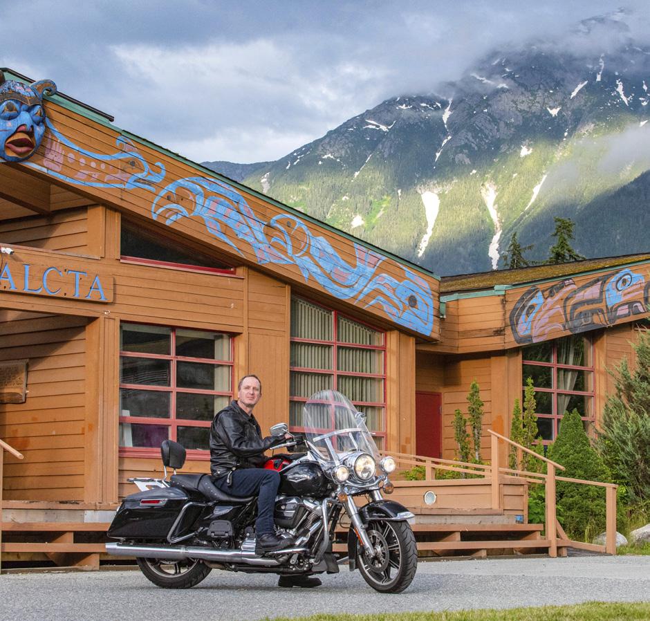

PERHAPS LIKE MYSELF, you don’t own a motorcycle and never have. Perhaps like myself, you’re drawn to the experience of riding a Harley Da-
vidson or a sport bike on some of the country’s most scenic roads. Perhaps you’re also nervous about high speeds, or taking dumb risks, or not willing to drop thousands of dollars on a bike you might only ride a few weeks a year. Luckily there are several companies in BC that offer motorcycle rentals, including Cycle BC, International Motorsports and EagleRider Rentals. I opted to rent a classic Harley Davidson Road King from EagleRider for roughly $100 per day, gas included, which was easier and more affordable than I
26 • BC MAG
expected to find my dream machine. Now I needed a road trip.

BIKERS FIND EACH other, because it’s fun and considerably safer to travel in groups. Riding in staggered formation, groups own the road and rarely get overtaken. I was fortunate to join (let’s avoid the word ‘crash’) an annual road trip of a regular group ranging in age from 24 to 60. They’d spent many months planning a trip north from their home base in Victoria, taking the 10-hour ferry to Bella Coola, and
returning south via Vancouver over five days. I met up with them heading north along the island’s Highway 19, getting familiar with the bike, lifestyle and landscape. I could smell forest earth and ocean salt, the new rain and tilled farmland. Road trips in cars put us in a closed box as the world passes by. On the motorbike, I found myself fully immersed, in the moment and constantly adjusting to the environment.
We roll into Dave’s Bakery in Campbell River, devour the best Reuben
Scenes from the journey, including a ferry ride from Port Hardy to Bella Coola.
sandwich on Vancouver Island, and discuss the trip ahead. Bikers are like anglers; eager to share war stories, technical tips, sage advice and the odd tall tale. All agree my Harley is the most powerful bike in the group, worthy of admiration and a fair amount of ribbing too. The Harley sub-culture deservedly tends to inspire both envy and ridicule.
We leave Campbell River and haul up the coast, traffic dissipating as the meandering asphalt cuts through endless forest. Rolling through small communities, each settlement feels more interesting than it does when seen through a car windshield. We constantly pull off to look at roadside attractions and viewpoints. Sometimes we open our throttles, sometimes we ride well below the speed limit in formation. Although my motorbike experience is limited at best, I feel comfortably safe in the leather saddle and grateful for my motorcycle’s forgiving clutch. We arrive in Port Hardy to spend the night in the excellent Indigenous-owned and operated Kwa’lilas Hotel. Feasting on memorable salmon-encrusted halibut in the adjacent pub, we look forward to the early morning ferry.
BC FERRIES’

NORTHERN
Sea Wolf is a 76-metre-long vessel offering yearround service between Port Hardy and Bella Coola. Taking just 35 cars and 150 passengers and crew, we’d reserved months in advance as the spacious ferry fills up in the summer months with RV’s and campers. We ramped on the 7:30 a.m. sailing, strapping our bikes down to counter strong waves that fortunately did not materialize. On the upper deck, we joined German, French, Dutch and local
BC MAG • 27
A road trip isn't a road trip without a breakdown somewhere along the way.


tourists taking in the extraordinary coastline, framed by King Island and soaring cliffs on the mainland. The captain made regular announcements about whale sightings and a humpback breached for us as if on cue. It’s a long, comfortable journey, with time to play cards, chat with travellers, gaze at the sea channel and look forward to the challenge ahead.
Bella Coola serves as a gateway to the Great Bear Rainforest, and a centre for bear-watching and outdoor adventure tours. We struck out early, anticipating issues along Highway 20’s infamous Hill. Full of switchbacks, steep inclines, single lane passes and hardpacked gravel, unseasonal wet weather had created long stretches of choppy mud. The hybrid off-road bikers in our group licked their lips, but I decided to call the cavalry. A friend in Williams Lake borrowed a trailer to help my Harley get over a notorious hill in horrendous condition. No need to be a hero. Although the motorcycle lifestyle promises renegade freedom, the truth is that most riders are not outlaws “Wanted Dead or Alive.” They’re wanted back in the office on Monday morning.
I REJOINED MY mud-baked group at the other side of The Hill, who confirmed the value of having good friends with trailers. We fuel up in Nimpo Lake, and speed out into a dramatically different landscape. It’s a long, wild biking day with everything: sun, rain, mud, curves, flats, horses, cows and the shadows of moose. Lush farmland, burned forests, snow-
capped peaks, marmots and mosquitoes the size of marmots. After 90,000 kilometres of reliable road trips, the Honda Shadow in our group rattled to a stop, defeated by age, mud and questionable mechanical maintenance. We arrange a tow to Williams Lake, divide up the saddlebags, invite the rider to hop onto the back of another bike, and start the debate of which bike he should buy—or rent—next. Every bike trip is an adventure and all agree you can replace a motorbike, but not a rider.
SOUTH FROM WILLIAMS Lake, the topography is more dramatic. Sage brush bristles in the breeze as we slowly snake through narrow mountain canyons carved by the mighty Fraser River. Dozens of bikers are gathered in Lillooet for the night, heading north or south. We admire machines, compare road conditions, and begin planning next year’s itinerary. East to Alberta? What about south into the US? It’s something to think about as we wind our way to Pemberton and onwards to Vancouver, riding the world-renowned Sea to Sky Highway. 1,800 kilometres and five incredible days later, I returned my bike that afternoon, greeting staff with a big smile.
Whether you used to ride, want a different ride or harbour a dream to ride the open road, renting motorbikes is an affordable, easy and magical opportunity. I already know what bike I’m going to rent next year. When you see me on the road, don’t forget to wave.

BC MAG • 31
Nothing connects a traveller to their surroundings quite like riding on a motorcycle.
ARCHIE’S GUIDE TO
HIGHWAY 37
EXPERIENCING THE WONDER OF BC’S NORTH
 BY RICK HUDSON

Northern BC Tourism/Andrew Strain
Archie says it’s a go, and he’s been driving the Stewart-Cassiar since, well, since the other Trudeau was Prime Minister. You can’t go wrong with my friend Archie. He knows a thing or two about Highway 37. He’s had more adventures there than Rick Mercer has had rants, and that’s saying something.
So, we’re heading north, leaving Highway 16 and the Lake District behind, and rolling into the great unknown. To us. To Archie, those 725 paved kilometres (give or take) are old hat and that’s why we’re going with him.
We start at Kitwanga after crossing the mighty Skeena River. It’s the second longest river fully in BC (after the Fraser) at an impressive 580 kilometres, but who’s counting, eh? The Skeena is an important salmon river, especially for sockeye, and starts way up north on the Spatsizi Plateau, where we’re headed. Which is where the Stikine, Nass and Dease rivers start too, only they go west, southwest and north, while the Skeena flows south. By the time it passes Kitwanga, the Skeena is well over halfway to the sea at Prince Rupert, and over 200 metres wide.
We fill up at the gas station on the corner of 16 and 37 and then drive over the Skeena bridge. Archie advises that the bridge was built in 1974, replacing the old rail and road bridge about a mile upstream. That one was built in 1925 and replaced a ferry service. “Progress,” says Archie, “it’s all about progress.”
The road itself has a good surface, and the traffic dwindles quickly, mostly just commercial trucks and the occasional RV
(like us). Highway 16 and 37 are a popular alternative to the Alaska Highway. It’s slightly shorter but no quicker. Mostly, it’s just different, and you’ll see a lot fewer vehicles than the other route. Plus, it visits some equally interesting places that in Archie’s opinion … but you don’t want to hear what Archie thinks. Right now, we’re rolling north and the road demands our full attention as one curve follows another.
AT GITANYOW WE turn left off the road and drive into the Gitxsan village where there are towering totems to be seen. During Covid, the village closed to outsiders and underwent a significant upgrade in roads, with much new paving. Open for tourism again, the village’s poles are special for a number of reasons. After the potlatch ceremonies were banned in the late 1800s, totems were carried off to many museums around the world. Many of the original Gitanyow poles ended up in the BC Museum in Victoria and were replaced with replicas, including the “Hole in the Ice” or “Hole in the Sky” totem that was erected in 1850. So, these are some of the oldest poles still standing. Marvel at the skilled craftsmanship, and know that each tells a story about origins, clan relationships, property rights or more.
It was here and in neighbouring Kispiox that artist Emily Carr painted some of her most famous totem canvases. The rows of traditional longhouses she recorded have gone, replaced by modern homes, but the aura remains. This is a special place. We park in front of the grocery store and wander around in quiet respect. Even Archie is silent.
The nearby Meziadin River has been the lifeblood of the Gitxsan people since time immemorial and Meziadin Lake up north is the heart of sockeye country. The lake is where a paved road runs west (the 37A) down to the coast at Stewart. “Not to be missed,” says Archie, so we gas up at the junction and turn to follow the setting sun over Bear Pass. The highway climbs 200 metres to Strohn Lake, where we pull off on the gravel verge and take a walk. There’s a westerly howling through the gap in the mountains, and the muddy
surface of the lake is being whipped into a steep chop.
Across the lake is the Bear Glacier. Archie cups his hands to his mouth so we can hear above the wind. “That ice has retreated a whole lot in just five years since I was last here,” he says. “Pretty soon it’ll be out of sight.” It drains the north side of Otter and Cambria peaks. Although the icefield above will still be there for

34 • BC MAG
A
decades, the white tongue of ice curving down to the lake—a great favourite with photographers—will be a thing of the past. Images from just a few years ago show the glacier at the lake; now, it’s melted upslope a long way.

IT’S RAINING IN Stewart, but that doesn’t detract from the small-town, friendly feel of the place. The old build-
ings along 5th Avenue still have a pioneer feel to them, reminiscent of the gold and silver mining heydays of yore. Check the excellent museum for a history lesson. At the Visitor Centre there’s help and suggestions on what to do, and next to the centre there’s a raised boardwalk out across the salt marshes of the estuary. On sunny days it provides spectacular views of the town’s situation, sandwiched be-
tween high peaks on either side (often snow-capped) and the Bear River. To the south, long, thin Portland Canal stretches 150 kilometres to the open sea; it’s the start of that great undefended 2,500 kilometre boundary between Canada and Alaska, all the way north beyond the Arctic Circle.
Just two kilometres down the road is the US border and the hamlet of Hyder
The Salmon Glacier is one of Canada’s largest. A 2WD road leads to a dramatic viewpoint above the ice, looking west to the boundary peaks along the Alaska border.
Tourism BC
(pop. 60 in the winter). Because there’s nowhere to go from there (more on that in a minute) it’s one of the very few entrance points where there’s no Uncle Sam waiting. But don’t forget to take your passport, because you’ll want to get back into Canada, and there is a Canadian Immigration post on your return!
When the salmon are running in midJuly to September, one of the north’s best experiences is just beyond Hyder at the Fish Creek Wildlife Observation Site. A raised walkway parallels the river, and it’s a favourite spot for bears to hunt pink and chum salmon. Hang over the rails and watch what’s happening below in relative safety. Signs remind you not to walk on the roads (bears walk on the roads) and to be careful getting out of your vehicle in the car park (bears wander through here too).

On that same road, and the highlight of many people’s trip to the region, is a visit to the Salmon Glacier at the head of the valley. It’s a 39-kilometre drive from Stewart through Hyder and up a long, switchback road. Archie doesn’t recommend it for RVs, but a competent 2WD vehicle will make it, with care. It’s an unpaved mine road that leads you back into the Canadian alpine (no border stops) and brings you out opposite the Salmon Glacier’s terminal. The guidebooks (and Archie) will tell you it’s the fifth largest in Canada. On a sunny day the view is extraordinary. The road transits above it, so you look down and across at a spectacular sweep of snow and ice that breaks up into crevasses and seracs at your feet. Bring warm clothes, cameras and lunch, to savour this natural wonder.
BACK AT MEZIADIN JUNCTION, it’s time to turn north again on Hwy 37. The highway follows a valley peppered with lakes on the west side. Many have provincial parks on them, but most are day-use or tent-camping only. Eighteenkilometre-long Kinaskan Lake is different. The south shore’s park has 50 RV sites, many with glorious views up the lake. Dawn and dusk produce some rich Kodak moments.
Just north of Kinaskan is Tatogga Lake. The Lodge is a must-stop if only to admire the mounted wildlife in the restaurant (the burgers are great too). We fall
into conversation with a staff member who explains all the things to do in the region, with the aid of a large wall map. For much of the summer, Alpine Air has a floatplane at the lake, providing access to a host of remote locales both to the west (Edziza Provincial Park) and the east (Spatzizi Plateau Wilderness Provincial Park). It’s important to call their head office (in Smithers) and plan ahead. The summers are short and there’s all-day pressure to fly passengers into the backcountry to hike, fish, hunt, kayak, raft or just camp. June to mid-August are the busiest times.
At the check-in counter we give our names, and the lady behind the desk comments, “That’s an unusual surname. I used to teach at College of New Caledonia with someone by that name.” She stares at our masks. Then the light goes on. “Joan?” “Bob?” They fall on each other like the old friends they were 30 years ago. There’s much laughter and ribbing as masks are pulled off and they recognize each other.
“What brings you here?” “We were hoping to get into the Edziza,” says Bob, “but the plane at Tatogga has gone south already.” Joan’s eyes twinkle. “Ours hasn’t.

The temperature’s down and it’s still raining. Our waiter at the restaurant explains that because of the forecast, the floatplane has already left for its base down south. Archie’s language is colourful at this news. We had plans to fly into the Spectrum Range for a couple of days.
But wait—Archie has a Plan B. There’s sometimes a Klappan Air floatplane at Kluachon Lake a bit further north. After lunch we drive the short distance on Hwy 37 and then down the steep gravel road to Mountain Shadow RV Park. We’re all wearing Covid masks out of courtesy to the locals, who often regard us as nothing more than disease-carrying scruffs from the south.
My husband Keith has his plane here. He’s busy, but not THAT busy.” Archie grins. It’s karma. Or luck. Whatever it is, we’re all pleased.
But summer is over, it seems, and the rain keeps falling for the next two days as we wait for a weather window. The temperature stays close to zero at the lake, and when the clouds lift on the third morning, there’s snow on the tops of everything. We were hoping to camp 600 metres higher than where we are, so it looks sketchy. We discuss the options back and forth as the rain continues. Joan reports the forecast is improving tomorrow.
Archie puts it best. “We’re here, now.
36 • BC MAG
Left: Between mid-July and September there’s excellent bear watching from a boardwalk at the Fish Creek Wildlife Observation Site. Right: The Gitanyow totem poles are some of the oldest in the province. Each records details of clan affiliations, or property title, legends or more.
Phillipa Hudson X2


Hazelton Kitwanga Gitanyow Kispiox Portland Canal Edziza Prov. Park SPATSIZI PLATEAU WILDERNESS PROV. PARK Smithers Kluachon Lake Mt. Edziza + Grand Canyon of the Stikine Morchuea Lake Upper Gnat Lake Dease Lake Cassiar Good Hope Lake Boya Lake/Tā Ch’ilā Prov. Park McDame Mountain + Watson Lake 97 Bear Glacier Fish Creek Wildlife Observation Site Salmon Glacier Stewart Hyder Meziadin Lake 37 37A Stewart Area of Enlargement 16 ALASKA B R I T I S H C O L U M B I A YUKON 0 30 60 Kilometres 37

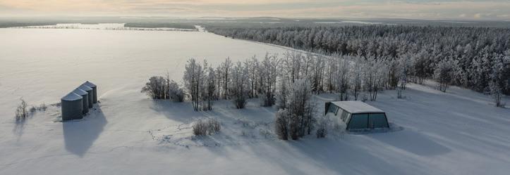
Boya Lake in Tā Ch’ilā Provincial Park is famous for its turquoise waters, formed when pale marl (a limestone derivative) coats the bottom of the lake. In mid-summer the water is warm enough to swim.

Northern BC Tourism/Andrew Strain
Let’s make the most of the bad weather. We might not get to camp at 1,500 metres in ankle-deep snow, but we should make the effort to at least see the place.” We concur. Keith the pilot says he’ll take us flight-seeing.
THE NEXT MORNING dawns mostly clear, with fresh snow sparkling on the summits. The de Havilland Beaver climbs out of the valley, its rotary engine howling while Keith gives us a running commentary. He’s been a bush pilot, outfitter, hunter, helicopter base manager and married to Joan for over 50 years. He knows this territory like the back of his hand, and for the next hour and a half he shows us the wonders of the Edziza Plateau. By the way, it’s pronounced ‘edseye-za’. The name means ‘cinders’ in the Tahltan language.
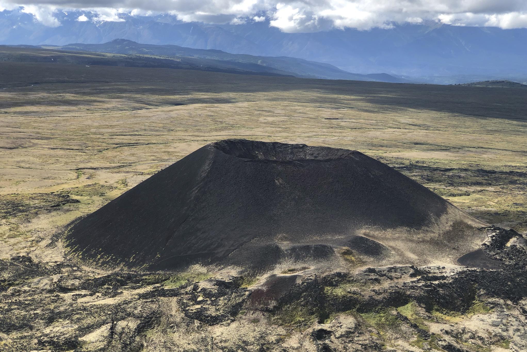
The park has no vehicle access. It was established in 1972, and encompasses 2,660 square kilometres of complex volcanic terrain. It’s part of the line of volcanoes that stretch right up the west coast of North America and into Alaska. Earthquakes are not uncommon. A 7.7 magnitude quake occurred near Haida Gwaii in 2012. The park’s rocks are young—about 7.5 million years old— with recent minor eruptions forming perfectly symmetrical cinder cones, unblemished by the last Ice Age.
As the plane gains height, we swing around the south end of the plateau and the orange and red tones of the wellnamed Spectrum Range come into view under the right wing. Such colours—the rhyolite hues enhanced by the white of freshly fallen snow.
The summit of Mount Edziza (2,780
metres) is well glaciated. The south side, which gets the prevailing sun, is more broken and crevassed than its counterpart on the north. What comes across as we slip in and out of pockets of cloud, always keeping the peak on our right, is how wild and barren it appears. It’s sand, gravel and black basalt with little vegetation. Only at key passes between the radiating hills do we discern faint tracks where animals and hikers have crossed from one valley to another. Otherwise, the region appears supremely untouched, the way parks ought to be.
North of the main peak, long lava flows run down to the edge of the Grand Canyon of the Stikine. There, that 600-kilometre-long river squeezes into a slot so deep and narrow that it resembles a knife-cut through the plateau. Keith turns the plane and we follow it

40 • BC MAG
The weather finally cleared and bush pilot Keith Connors was able to take the group flightseeing from Kluachon Lake over Edziza Provincial Park.
upstream. In places it’s reported to be just three metres wide. Once considered ‘the last great problem of North American kayaking’ it was finally run in its entirety in 1990. However, such is the pace of extreme sports, 15 years later it was run in a single day. And in 2017, twice in a day! “There’s always one in the crowd,” says Archie.
WE’RE BACK ON the highway again.
As we drive away from Morchuea Lake, Archie observes that watersheds have always intrigued him. It’s not far before Hwy 37 crosses the Tanzilla River, which drains west into the Stikine and hence the Pacific Ocean. But just a short distance further we cross into a different catchment, where a raindrop starts its long journey via the Dease River into the Liard River, curving around the
north end of the Rocky Mountains and hence into the Mackenzie River, ending up in the Arctic Ocean—a journey of nearly 4,000 kilometres. Northern Canada is huge.
On the divide we reach the somewhat uninvitingly named Gnat Summit (1,241 metres) where there’s a spacious pullout next to Upper Gnat Lake. Happily, it’s too late in the season for bugs. The sun is out and the surface reflects the blue sky, with a new dusting of snow on the hills across the water. Loons call from the lake as it turns into an iconic northern evening.
Above the highway we see the abandoned bed of BC Rail’s northern construction, never completed. It was Premier W.A.C. Bennett’s dream to drive a rail line to the Yukon boundary, but it never happened. The cost of crossing
such complicated terrain turned out to be double the estimate. The project was finally shelved in 1978, having gone 300 kilometres beyond Prince George to Dease Lake.

Talking of Dease Lake, the next morning we halt there to gas up, but the Petro-Canada is more than just a fuel stop. The outfitter’s store has everything you would ever need to hang out in the north, from snowshoes and work boots to hunting and fishing gear and bug spray. Whatever you forgot to pack in the south, it’s likely they’ll have it, in three sizes and two different colours. This continues a longstanding trading tradition: Dease Lake town is close to a Hudson’s Bay trading post known as Lake House, founded in 1837.
The Telegraph Creek Road runs southwest from town. Under better
BC MAG • 41
The well-named Spectrum Range lies at the south end of Edziza Provincial Park. Sulphurous minerals in the rhyolite produce a variety of striking colours.
Phillipa Hudson X2
conditions we’d take the time to explore it, but bad weather and the fact there’s a washout and construction dissuades us from trying it this trip. It’s 112 kilometres of unpaved road and there are no services at the end. Be self-sufficient. If you think it’s tough driving, consider the great Canadian geologist George Dawson, who explored much of the region. It took him two and a half days on horseback to reach Telegraph Creek from Dease Lake back in 1887.
On the way down, at the confluence of the Stikine and Tahltan rivers is the Tahltan community. On the canyon wall across the river is an impressive basalt cliff known locally as Sesk’iye cho kime (pronounced ‘sis-kai-cho-kima’). It means ‘home of the crow.’ The bird’s spread wings are obvious; the feathers are comprised of vertical basalt columns, to dramatic effect.
Telegraph Creek has a population of about 250 permanent residents, and an interesting history. A prime fishing spot for the Tahltan First Nations, in the 1860s a telegraph company planned to use it as the start of an underwater cable to Europe (“That doesn’t make a blind bit of sense,” says Archie) via the Bering Strait, but lost out to a trans-Atlantic cable that ran from Newfoundland to Ireland—a considerably shorter distance. Nevertheless, the name ‘Telegraph Creek’ stuck. In the 1870s it became a starting point for numerous gold rushes to Cassiar, Cariboo and Klondike.
A DAY LATER we drive past Good Hope Lake and turn down at Boya Lake. The park was recently renamed Tā Ch’ilā Provincial Park, which means ‘blanket full of holes’—for the many bodies of water which fill the valley. There are 42 campsites, many on the lake. The water is a pale blue-green, lightened by dissolved white marl on the bottom, a result of erosion from upstream limestone peaks. It’s shallow and often warm, making for a rare swimming opportunity in the north. Canoe and kayak rentals are available from the Park Facilities Operator. Despite a moderately full campground, it feels like we have the whole
of northern BC to ourselves when we paddle among the islets. Recently gnawed aspens show where beavers have sourced their building material for a dam upstream. Archie advises there’s a local legend that says when the yellow swallowtail butterflies arrive at Boya Lake, the salmon are running at Tele-
graph Creek. There are many butterflies. A day or two later we drive the final 86 kilometres to Hwy 37’s junction with the Alaska Highway, aka Hwy 97. Just 23 kilometres east is Watson Lake; Whitehorse is 420 kilometres to the west. But Hwy 37 is over. “Well,” says Archie, “wotcha think, eh?”
Alexander Mackenzie passed the confluence of the Liard and Mackenzie rivers in 1789 and in 1803 a fur trading station was established there— later named Fort Simpson. In 1834, John Macleod reached the headwaters of the Dease River which was home to what today would be known as the Three Nations (Tahltan, Kaska and Tlingit peoples). He noted birds’ nests lined with yellow fibre, and fabrics woven from ‘mountain goat wool’ that didn’t burn. This was the unknown mineral asbestos.
In 1949, a Geological Survey of Canada expedition spent four days at McDame Mountain and positively identified the mineral, but due to its remoteness, assumed it wouldn’t be developed for decades. Yet that same winter a prospector sledded in and staked the first of many claims. The race was on!
With improved access via the Second World War-built Alaska Highway, the Cassiar Asbestos mine started, as the demand for this new wonder material rose. It was used in vehicle brakes, non-flammable cloth, high-strength concrete and house
insulation, to name just a few applications. Fibrous and fire-proof, it seemed to have an infinite number of uses.
An open pit mine started in 1951 under McDame Mountain, and the town of Cassiar followed, six kilometres to the south. By the 1970s, there was a population of 1,500 and a booming economy with schools, churches, a sports arena, a small hospital and even a theatre.
Mining was done by blasting in the pit, with the ore carried via tramline down to a mill. As they moved round the pit, miners noticed that one zone had a particularly hard rock which was of no apparent value. It was dumped, while the asbestos mining continued.
Jade was not a wellknown mineral back then, although a prospector, Bill Storie, had identified it on his claims on Wheaton Creek east of Dease Lake, in 1938. In 1967, one of the mine’s mechanics, a man named Clancy Hubble, who was also a rockhound, became intrigued by the hard rock waste. He sent a sample to the Dept. of Mines in Vancouver for analysis. The report confirmed it was nephrite
jade. The mine bosses had no interest in it, so Hubble got permission to stake the area where the waste had been dumped. He estimated there might be as much as a thousand tons of jade.
Within a few years the mine’s management began to realize their ‘waste’ was worth more per ton than their highgrade chrysotile asbestos! After some adjustments, most of the annual output (100 to 200 tons) was shipped to Taiwan. Initially, the buyers didn’t like the characteristic green chrome ‘fleck’ in the material, but later came to prefer it and paid a premium.
With rising concern about the link between asbestos and lung cancer, chrysotile sales began to drop in the 1980s. The need to stop open pit mining and go underground was an added financial hurdle. In 1992, Cassiar Asbestos closed. The mining equipment was sold off, as were buildings in the town, but most were simply dismantled, burned or buried. Today, a 12-kilometre drive west off Hwy 37 reveals another fascinating BC mining ghost town.
42 • BC MAG
THE CASSIAR MINE STORY

BC MAG • 43
Close to the highway, Upper Gnat Lake provides a wilderness campsite for RVs. Near this point a watershed divides the Pacific and Arctic ocean catchments.
Recent volcanoes on the north side of Mount Edziza have symmetrical cinder cones. Barely 150 metres high and 1,300 years old, they remain unshaped by glacial erosion.
Phillipa Hudson X2
THE MUSKWA-KECHIKA: LAND OF LEGACY
COWBOY DREAMS FULFILLED IN THIS TWO-WEEK TREK THROUGH “THE SERENGETI OF THE NORTH”
 BY JASON HARMAN
 Wayne Sawchuk
The impudent brute clamped down on my little sausage fingers so hard that the entire North Island was subjected to my agonized wails.
But here’s the thing: I’ve always wanted to be a cowboy. It’s the whole ensemble—the hat, the leather, the swagger— but more than all that, it’s the freedom of the hills that has always appealed to me. The horse has only ever been an object, a necessary evil, a means to an end.
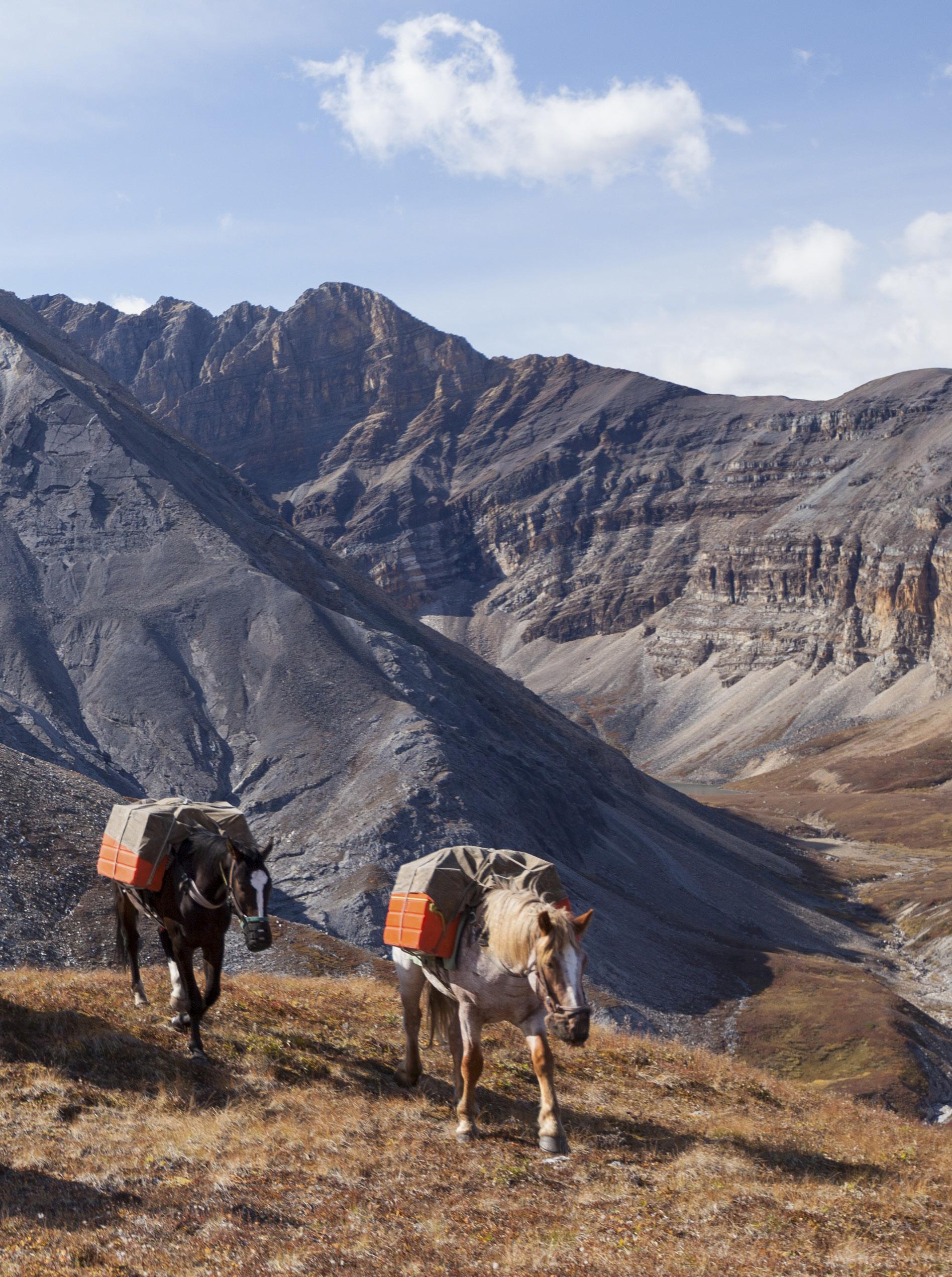
Given all that, it’s somewhat surprising that I now find myself perched atop a large mountain horse, surrounded flank-to-flank by 19 other large mountain horses and eight other riders, collectively careering into one of the remotest regions in North America. It’s my first day of a 14-day horseback expedition into the Northern Rockies of British Columbia, and all I can think is, “What the hell am I doing?!”
When I first heard stories about the Muskwa-Kechika—a 6.4-million-hectare area roughly the size of Ireland and twice the size of Vancouver Island— they sent chills up my spine. There is a place, the stories said, almost entirely roadless and undeveloped, where the air and waters are clean and pure, and the wildlife is so prolific that it is known as the “Serengeti of the North”—a true wilderness. Its name, spoken with reverence in a flowing half-whisper: muskquah-ke-chee-kah.
IF YOU HAVEN’T heard of the MuskwaKechika (or M-K), you’re not alone; most British Columbians haven’t either. Yet it is the largest contiguous wilderness area on the North American continent, surpassing even the likes of the Wrangell-Saint Elias, Mollie Beattie, Noatak, and Gates of the Arctic wilderness areas. The M-K comprises 50 undeveloped watersheds and a great abundance and diversity of species, including grizzly, moose, wolf, black bear, lynx, bull trout, grayling, caribou, elk, bison, mountain goat and stone sheep.
Translated, Muskwa means “bear,” and Kechika means “long inclining river.” (They also happen to be the names of two of the largest rivers that flow through the area.) The combination of its size, intactness, geographic diversity, and biodiversity makes it a truly exceptional place.
The horse I’m riding is a draft breed— a Belgian/percheron cross—named Anna. She is a friendly mare (or so the guides tell me), but she and I aren’t getting off to a great start. She is aloof and unresponsive to my requests. We do not see eye-to-eye. So far, we have both fallen over multiple times; she has run off midway through the mounting process; she has casually rammed me into several objects, including tree branches, tree trunks and other horses; and she has stood on my toes with her immense, metal-shoed feet. But, despite all that, she has successfully hauled my 230-pound frame through knee-deep mud, across numerous creeks and rivers, over fallen logs and up a few vertigoinducing mountainous inclines. She’s a working horse, I realize, and she’s getting the job done. Plus, given my aforementioned disdain for all things equine, I recognize that the problem likely rests with me. So, I implement a new strategy: sucking up. I feed her grass at every opportunity, pet her softly and whisper sweet nothings in her ear—peace by seduction is the goal.
When we finally reach the first camp alongside the Tetsa River, I am exhausted and my butt is sore from my first-ever full day of riding, but I feel like I’ve accomplished something. As I de-saddle Anna, Alex Lepp, the head guide for the trip, comes over to talk to me. “If you really want to get on her good side, try stroking her here,” he says, moving to Anna’s side and rubbing under her armpit. “She loves it.” Sure enough, as he rubs the spot, her lip starts to curl, her eyes droop, and she lets out a soft sigh. Hamish Davidson, the other guide,
walks over to join us. “I like to kiss them on the cheek,” he says, gently reaching for Anna’s muzzle and planting one on her face. “The skin there is so soft.”
I take a closer look at the guides. They’re young and tall, with free-flowing brown locks, muscular arms, and calloused hands. Alex sports a thick beard and glasses, while Hamish has a set of prominent laugh lines bordering bright, cobalt-blue eyes. They’re both accomplished horsemen and genuine ramblers: Alex is a trained farrier and has ridden every summer in the MuskwaKechika for the past 10 years; Hamish has worked as a wrangler and guide for various hunting outfitters throughout the province. They’re a pleasure to be around—with gregarious personalities and hearty laughs—and don’t seem too rattled by a greenhorn like me. I get the sense they’ve seen it all before. “You’re doing great,” says Alex, looking at me earnestly. “Just try and relax into it; it’ll get easier. And remember the advice Wayne gave you.”
WAYNE SAWCHUK IS the man at the centre of it all. His vision and commitment provided the spark and the sustained fuel that gave life to the Muskwa-Kechika Management Area, and he is the owner/operator of MuskwaKechika Adventures. Unfortunately, Wayne couldn’t attend this expedition due to an “obstreperous knee,” but he still joined us for a fireside chat the night before we took up the trail. He was charismatic and engaging, and his presence calming. He wore a cowboy hat that shaded his weathered face, gentle blue eyes, and snow-coloured goatee. When I first met him, I thought, here is a guy who has lived an honest outdoors life.
He checked in with me to see how I was feeling about the upcoming trip, and so I explained my fear of horses to him. “I can understand that,” he replied. “But remember that you’re dealing
46 • BC MAG
I’VE ALWAYS DISLIKED HORSES. ONE OF MY FIRST MEMORIES IS GETTING BITTEN BY A HORSE WHILE LEANING OVER THE BACK FENCE OF MY CHILDHOOD HOME IN NEW ZEALAND, GENEROUSLY ATTEMPTING TO FEED IT AN APPLE.


BC MAG • 47
Top 2 Rows: Marco Delesalle; Bottom Row: Jason Harman

with another being. They have different minds than we do. You must be patient and learn to communicate with them; they’re individuals. Ask first, then tell.” He also gave me some riding pointers like, “Left is right, and right is wrong” (advice for mounting a horse) and “Always keep 25 percent of your weight in your stirrups” (for balance).
I sat with Wayne that night while he shared stories, effusing energy and passion. “I’ve been coming to this area, now known as the M-K, since 1984 when I was 29,” he said wistfully across the embers. Wayne grew up in the North and followed his father into a career as a logger. But day after day, as he worked the land by cutting and clearing old-growth trees, a nagging guilt started to gnaw at him from the inside out. Some days, the feeling would get so bad that he’d be physically sick. Something had to change—and so he did. He realized that this wild place needed a voice, a conduit and that he could fulfil that role.
The idea for the M-K began in 1993 with an ambitious campaign called “Northern Rockies–Totally Wild,” during a time when British Columbia was redefining its land use planning process. Wayne and fellow conservationist George Smith (then national conservation director at the Canadian Parks & Wilderness Society) rallied together with a band of unlikely allies—trappers, guide outfitters and biologists— to advocate for the creation of a new model. Six years of negotiations later, in 1998, the Muskwa-Kechika Management Area was finally legislated, and a new way of doing business in British Columbia was born. What makes the M-K approach unique in the world is that it is a “working wilderness:” a pragmatic approach that separates the land into zones and allows resource extraction only if strict environmental values are adhered to. There is also an advisory board, which Wayne has sat on since its inception. “It has not been easy, and it’s not perfect, but it works,” he said. “I think this model can, and should, be used elsewhere in the world.”
Wayne has been leading horseback expeditions into the M-K since the

BC MAG • 49
Destination BC/Taylor Burk
Muskwa-Kechika Adventures in Dune Za Keyih Provincial Park in the Stikine Region.
negotiations started in 1993, first with politicians, media and scientists, then with paying clients. Along with his wife, Donna Kane, they run the M-K Adventures ecotourism business out of their ranch in Rolla, BC.
“The main underlying focus of M-K Adventures is the conservation of the Muskwa-Kechika. If I can help by creating a business that brings people into the M-K, doesn’t harm the environment, creates employment for local people, helps to increase the area’s profile and ultimately inspires its protection—that’s my goal,” he said. “If you don’t know an area, you can’t love it. That’s why I do what I do.”
“My goal has always been for our customers to go away and tell people about the Muskwa-Kechika, and to carry it inside them. And ultimately, it may come to a point where we must fight for the Muskwa-Kechika, and I know that the people who’ve been here will put their hands up to help. They’re like a Fifth Army, you know. M-K Adventures is just a mechanism to make that happen.”
It turns out that the M-K’s “Fifth Army” includes some notable figures, like Harvey Locke, founder of the Yellowstone to Yukon initiative. In the summer of 1993, Wayne guided Harvey into the M-K on horseback. One night, inspired by the wilderness surrounding them, Harvey concocted an idea to conserve the ecological integrity of the entire Rocky Mountain ecosystem, from Yellowstone in the South to the Yukon in the North—the Y2Y corridor. The Y2Y initiative has since grown into an international organization that aims to protect and unify the Rocky Mountain landscape, to transition it from a postage stamp collection of parks to a coherent ecosystem that supports true and lasting wildlife connectivity.
THE FIRST WEEK of the trip flies by, filled with beautiful, warm days and stunning high-country panoramas. Thankfully, Anna and I work out our
differences. I get used to the rhythm of her walk and my body relaxes into the saddle. (I think she is enjoying herself a bit more too.) With each mountain pass and slippery river crossing, I whisper my gratitude and stroke her neck to offer moral support. The weather holds off, and we are spoiled with kingfisher blue skies, copious butterflies and fragrant flowering vegetation of every colour and ilk. Our necks crane trying to take in the immense, omnipresent peaks and their ever-changing moods. On rest days, we swim in turquoise pools and read alongside the river; we hike to waterfalls and hang out in camp, engaged in deep conversation. The nights are cold, so we wrap ourselves in the woollen horse blankets that provide padding underneath the saddles during the day. They smell strongly of horse sweat— musky, yet sweet.
Every night we let the horses free to graze and roam and allow them a fighting chance against predators like wolves and grizzlies. They are hobbled
basket hitches, diamond hitches and quick-release slip knots—and learn the names of the horses and the terminology for the various pieces of tack and camp equipment. We become a welloiled machine.
The flavours of the trip imprint on my memory: there’s the tartness of fresh dwarf blueberries, picked alongside the trail at every opportunity; the bitterness of Labrador tea, boiled for its medicinal properties; and the succulent umami flavour of lake trout, caught fresh from one of the many glacial lakes dotted along the route. I recognize these are Indigenous foods, and they make me think of the First Nations people upon whose territories we wander. As if to cement this fact, one day, Alex picks up a beautiful, angular stone on the side of the trail. It’s a spear point. We pass it around in awe, feeling connected to the past in a tangible way.
THE MUSKWA-KECHIKA lies within the traditional territories of the Kaska Dena, Treaty 8 and Carrier-Sekani First Nations. It is Indigenous land. Gillian Stavely, a member of the Kaska Dena community and director of the Dena Kayeh Institute, says that the M-K is “More than a wilderness; it’s our homeland.”
“Our community have lived there. Our babies were born there. Our people died there and are buried there. It is sacred land.”
(front legs tied) to prevent them from roaming too far and fitted with large bells around their necks that invoke the ambience of the Swiss Alps. Every morning the guides and wranglers must leave camp at 4:00 a.m. to search for them, following the horses’ tracks and listening for the ringing bells. Some mornings it can take hours to round them all up and get them back to camp. Once they return, the routine is always the same: pack up camp, saddle the riding horses and load up the packhorses. We all get proficient in knot tying—
The Kaska Dena are proposing an Indigenous Protected and Conserved Area (IPCA) over much of the M-K, called “Dene K'éh Kusān,” which means “Always will be there.” IPCA’s are a new tool in the hands of government and First Nations that allow for greater shared decision-making within protected areas and recognize the importance of Indigenous knowledge alongside science. They are not yet common practice in British Columbia and, in contrast to the M-K model, remain relatively untested. But the Kaska Dena believe that an IPCA is an essential step for ensuring the long-term protection of the area and is critical for preserving the material, cultural and spiritual lives of the Kaska people.

50 • BC MAG
Muncho Lake Fort Nelson 97 Liard River MUSKWA KECHIKA Watson Lake
BRITISH COLUMBIA
Y.T.
OUR SECOND WEEK FLOWS much
the same as the first. Time becomes irrelevant with the long northern days and the “real world” becomes abstract—a vague memory. We see several animals—moose, elk, caribou and grizzly—and are constantly surrounded by animal sign, like footprints, rubs and scat. The presence of predators keeps us honest and imparts a mindful awareness that keeps us grounded in the moment—the gift of the grizzly. I notice my legs have strengthened over the two weeks of riding, and my hands have toughened from the constant use of rein and rope. I find myself looking forward to the long, challenging rides with Anna and together we traverse the land with
vigour. I finally feel like a cowboy. (Albeit one with plenty still to learn.)
On our last night, we follow the usual routine of setting up our tents, cooking dinner over an open fire and sharing red wine and whiskey as the stars come out and the moon rises. The next day, we drop down the valley and are greeted by flaming yellow aspens signalling the land’s transition to fall. It’s a strange feeling returning to the craziness of civilization; as we near the Alaska Highway, it occurs to me that I haven’t heard a vehicle for two weeks—the longest period of silence in my life.
British Columbia’s North is a wild place that binds with your soul, and the Muskwa-Kechika is the jewel in its

IF YOU GO
M-K Management Area website: muskwa-kechika.com
Muskwa-Kechika Adventures website: mkadventures.ca
Wayne Sawchuk’s website: muskwakechika.com
Dene K’éh Kusān “Always Will Be There”: denakayeh.com/denekehkusan
crown. It is a legacy for all, thanks to the commitment of a few. For those with an adventurous spirit—like the salmon that chooses to swim up the wrong river or the bird that hitches a ride on the wind—this place will feel like coming home.
BC MAG • 51
Jason Harman

52 •BC MAG
GOING FOR GOLD
A BEGINNERS GUIDE TO THE TIME-HONOURED BC TRADITION OF GOLD PROSPECTING
 BY LINDA GABRIS
BC MAG •53 Northern BC Tourism
Beautiful British Columbia is full of spectacular places to visit but some of the most thrilling destinations are the historical gold-bearing regions and ghost towns scattered throughout our province. This is especially true for folks like my husband, Sandor, and I, who have been under the spell-binding power of gold since 1970, after having panned a few lustrous specks at the gold panning display in the historic town of Barkerville. Since that memorable day, we’ve had a neverending case of gold fever.
Throughout the years, we have traced the tracks of fortune-seekers who swarmed to the province from all
BC'S RECREATIONAL GOLD PANNING RESERVES
many times the elusive dream has lured us back, we always discover riches— sometimes far greater than gold.
RECREATIONAL PROSPECTING IS a fun, rewarding hobby that can be enjoyed from spring through fall and by folks of all ages. It pairs up perfectly with other outdoor activities like fishing, camping, hiking and sight-seeing. Heading into the hills, you’ll not only get a glimpse at modern-day, largescale gold mining operations— which are still taking place in BC today—but also see evidence of what the old sourdoughs left behind, and breathe some life back into history.
Over the past 50 years, we’ve come across abandoned miner’s cabins where lively spirits still linger, and decaying sluice boxes that teased us with visions of gold. We’ve seen old workings cluttered with obsolete mining machinery, rusting away beside mountains of tailings. And in the ghost towns we’ve visited quaint little churches where the faithful history makers prayed for riches and the peaceful graveyards where they rest.
over the world during the gold rush eras. We have cashed in on almost all of BC’s noted gold-bearing regions— including the rich Fraser River gravel bars, the Cariboo goldfields, the Omineca and Atlin. And no matter how
But before taking off on your goldseeking adventure, it helps to understand a bit about the fascinating properties of the precious metal. For starters, gold originates in veins, known as the motherlode, where it is typically attached to a host material, often quartz. Recovering the metal from the motherlode is known as hard-rock mining which involves drilling, blasting and refining, definitely not a recreational undertaking!
However, thanks to erosion, gold wears free from the motherlode and once detached, due to its denseness and gravity (which is 19.3, meaning gold is 19.3 times heavier than water),
54 • BC MAG
B
1. Kennedy River Reserve
2. Hope Reserve
3. Yale Reserve
4. Princeton Reserve
5. Lytton Reserve
6. Cayoosh Creek Reserve
7. Kettle River Reserve
8. Barnes Creek Reserve
9. Erickson Reserve
10. Wild Horse River Reserve
11. Goldstream Reserve
12. Fraser River Junction Reserve
1 3 2 6 7 5 4 13 8 9 10 11 12
13. Spruce Creek Reserve
natural forces draw the heavy metal downwards, travelling away from the lode.
As the free-travelling gold, known as placer gold, travels away from the lode it can become trapped on outcropping benches and ledges where it is sometimes found by prospectors. That which doesn’t get hung up continues its descending travels downward into valleys, gulches, gullies, rivers and streams where it is picked up and carried by water to further destinations. During its travels in water, gold is deposited on gravel bars, behind large
boulders in the river, in bends or wherever the water velocity slows down. Gold is often swept between layers of shale and some of the richest or most concentrated deposits have been recovered from the pockets and crevices of bedrock, a layer of solid rock which gold cannot penetrate. Placer miners like myself are always on the lookout for outcropping bedrock in order to pick its pockets!
Panning for gold is the simplest and least expensive method of recovery for novice and recreational prospectors. You can pan for gold using a gold

pan and shovel in any unstaked watercourse (river or stream) in BC and on Crown Lands which are not a legal staked gold claims and leases. The BC Ministry of Mines has also created a number of land reserves around the province which are open to the public for gold panning. Check out their website for maps.
As well as no gold panning (or mining in any manner) on gold claims and leases, you cannot pan for gold in parks or other protected areas such as reserves, on private property or First Nations land without permission.
BC MAG • 55
Gold pans are the classic go-to method for beginners. All that’s needed is some patience and a little luck.
Linda Gabris
WHERE TO PAN FOR GOLD


PANNING FOR GOLD
The equipment needed to break ground in this hobby is inexpensive and relatively easy to hunt down, with the most important item being a gold pan that can be bought online or at stores that carry hobby and outdoor supplies.


Pans come in various sizes—large, medium and small—so you can choose one that fits your frame, keeping in mind that a large pan filled with gravel is quite heavy to pack, especially when working any distance from the water. Gold pans also come in metal and plastic, plastic being lighter for toting in a packsack.
Any round-nosed shovel or garden scoop can be used for filling the pan with prospective gravel and a big sturdy spoon, a whisk and small dustpan comes in handy for digging paydirt out of pockets and for sweeping up gold-bearing material from crevices of bedrock.

You will need a poke (which is a leather pouch) or a plastic vial to hold the recovered gold, tweezers (should you need to pluck a wedged nugget out of a crevice of bedrock and for retrieving particles of gold from concentrates) and rubber gloves and boots to protect your hands and feet from the cold water. And with that, you’re good to go.
The concept of panning for gold revolves around the fact that gold is much heavier than gravel and sand. Here’s how it’s done:


FILL THE PAN ¾ full of prospective gravel, which will prevent overflow as you begin the process.

Find a calm spot in the river (or other water source) and sit your pan in the water, letting it rest on bottom.


56 • BC MAG
Slow running water behind boulders Target area Target area Target area Target area
The inside of river bends where the water runs slower
The best place to pan for river gold is where the water runs slowly. Gold is deposited on the inside of bends and behind boulders.
Now using both hands, knead the gravel, breaking up any hard-packed lumps of clay and compacted gravel which may contain gold while washing the material from rocks and pieces of shale before discarding.
With the pan slightly tilted towards the water, and working with the water to keep enough in the pan to cover the material, begin rocking and shaking the pan back and forth. After three or four good shakes submerge the pan under the water, tilt it away from you, and let the water flush the top material gently out over the lip.
Repeat the actions of rocking and shaking from side to side and flushing the lighter material out over the lip until the material in the pan has been reduced to a small amount, about a handful. This material is called the “concentrates,” typically made up of

black sand (which is magnetite, meaning when it is dried it can be separated from the flour or fine gold by using a magnet), small garnets and/or pyrites and, when luck is with you, gold!
To check for gold that is hidden beneath the concentrates on the bottom of the pan, put enough water in the pan to cover the pocket of condensed material. Twirl the pan in one direction in a slow, steady motion from top to bottom. As the concentrates are carried by the water to the bottom of the pan, the gold will hold its ground, remaining at the top.
Nuggets, of course, will be peeking up through the black sand and can be rescued first. After admiring their unique beauty (and once your heart returns to beating normally), you can put the nugget, or nuggets (yes, sometimes there can be several nug -
gets in one shot), into your poke for safekeeping.
Finer particles of gold can be picked out with tweezers and placed in the vial—or, do as I do and empty the concentrates into a lidded container and take them home to be cleaned out later at your leisure. Because right now you want to get back and finish cleaning up the paydirt from that hidden deposit you just unearthed.
DON’T BE DISCOURAGED if there is no pay in the pan! Not every pan will contain gold, unless of course, you are on a virgin piece of ground or you have hit what I tend to call the “motherlode” or a “hot spot.” Empty pans are to be expected and this is what makes the hobby so darn captivating–the thrill of never knowing what’s in the pan until you give it the final twirl.
METAL DETECTING
Nothing is more fun than metal detecting for placer gold. I bought my first metal detector years ago after I read about a million-dollar nugget found in Australia by an “electronic” prospector. The captivating article about the immense nugget got me totally hooked on metal detecting and I have unearthed some great treasures over the years—everything from worn-thin coins, an antique Chinese tobacco tin and remains of an old gold watch, to silverware and rusty nails. Yes, even some gold nuggets, which are the thrill of a lifetime when the discriminator on the detector is set to gold and the machine is beeping like crazy–you know treasure has been struck!
BC MAG • 57
Gold panning kits are easy to find online, and give you all you need to start panning for gold.
When I bought my detector there were not as many models or available features as there are on the market today. But regardless of what kind of detector you have, it’s important to practice with your machine at home in the yard before hitting the goldfields.
I learned how to use the discriminator (various settings for various metals) on my detector by burying a nail, a dime, nickel and penny, a sardine can and an old gold ring in the backyard garden. I then “beeped” the hidden items back out, tweaking the settings as I worked. I also played around with
depths to get a feel for the strength of the detector.
The most prospective place to find gold with a metal detector is, naturally, on areas of outcropping bedrock where the gold may be hidden in cracks and crevices, and in old tailing piles where nuggets may have been washed out of sluice boxes, or too big to fall through the screens. Some of the most impressive nuggets I have beeped out have been from old tailing piles and from pockets in the bedrock on gold claims that we have leased and worked over the years.
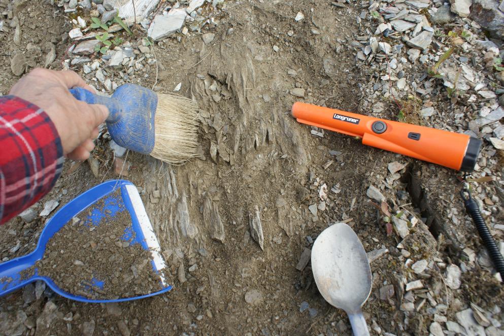


SLUICE BOX
Here’s a handy piece of equipment for increasing gold production. Most experienced gold panners can pan about one cubic yard of gravel a day whereas using a small portable sluice box can process the same amount in about one hour. But you must be on your own, or on a leased claim with permission, in order to sluice for gold. You must also be aware of rules and regulations regarding sluicing.
A sluice box is a narrow box which contains a rug or mat on the bottom
58 • BC MAG
Gold can get trapped in layers of bedrock. There's no thrill greater than spotting a nugget of lustrous gold.
Linda Gabris X4
that is held down firmly with a screen or several screens. The rug and screens are used for trapping the gold. The sluice box is sat on an angle, prospective gravel is shoveled into the top of the box and water is poured over the gravel. As the water flows out of the box it carries away the lighter materials while leaving the gold trapped behind in the screens and on the rug.

After several hours of feeding the sluice box, it can be “cleaned out.” The screen is removed, nuggets retrieved if visible, and the mat washed in the gold pan to retrieve the flour or finer flakes of gold. It’s very exciting to clean up the rug from a sluice box that has a nice accumulation of gold, typically much more than can be retrieved in a single pan.
DREDGES
I mention dredging because Sandor and I used a dredge for a number of seasons on a gold claim in the Omineca, which we leased from the owner. Dredges are expensive. The rules and regulations regarding using them can be very complicated and strict, especially regarding waters that have fish populations that must be protected.
However, on the claim we worked on, we used our dredge on an open piece of ground high above the river where the owner had worked a large area with heavy-duty equipment, clearing off the thick layers of rich paydirt from the bedrock.
As they worked the ground with machines, ground water kept seeping in preventing the operation from cleaning out the rich crevices and pockets in the bedrock. Enter the dredge, which works like a vacuum cleaner sucking up the gold-bearing material

along with the water, which then goes into a built-in sluice box where the gold is trapped and the tailings make their way out. The dirty water from the dredge remains in what is called a “settling pond,” preventing it from enter-
ing the river. Dredges are not intended for use by the novice gold prospector or those who do not own or lease a
WHICH TAKES US back to the gold pan, the number-one piece of gold mining equipment needed for breaking ground in this exciting hobby. So, gear up and get going. I promise you there are many riches just waiting to be discovered.
BC MAG • 59
A sluice box is more efficient than a pan, but is generally for more experienced prospectors.
URBAN GARDENING
WITH RISING FOOD COSTS AND CONCERNS OVER FOOD SECURITY, NOW IS A GREAT TIME TO DEVELOP YOUR GREEN THUMB RIGHT IN YOUR BACKYARD

 BY JANE MUNDY

 Lianna Glass
City Beet Farm co-owner Duncan Chambers with Aylah and Haley, preparing a strawberry patch near Main and 47th in Vancouver.
Lianna Glass
City Beet Farm co-owner Duncan Chambers with Aylah and Haley, preparing a strawberry patch near Main and 47th in Vancouver.
Whether it is being shocked by rising grocery costs, wondering why some veggies aren’t on store shelves or making tough decisions on what goes into the cart. According to Canada’s Food Price Report 2022, the cost of vegetables will outpace other food categories and is expected to see an eight percent hike this year. Yikes!
I’ve always grown vegetables. I went through the ‘back-to-the-land’ phase years ago, but I always thought it was cool to be self-sustaining. Now it’s almost essential. And what could be more rewarding than to serve veggies still warm from the sun to friends and family, that you started from seed? Remember the 100-mile diet that advised us to buy local, organic and seasonal whenever possible? Looking at my front garden and irritated by my lawn’s demands, I realized that a 100-yard diet was within my reach.
GET OFF THE GRASS

Lawns. What are they good for? Absolutely nothing, unless you play golf. Cultivating my lawn was a waste of time, space and money. It required endless hours of maintenance and gave me nothing in return. Heck, I didn’t even have garden gnomes or lawn chairs on my grass; the only time I inhabited my turf was to weed-whack or mow.
We know that lawns negatively impact the environment. Mowers and trimmers contribute to greenhouse gas emissions, and many of us “protect” the grass from invading plants with pesticides that can wind up in our water supply. Research also shows that 29 of the
30 most used lawn pesticides are toxic to birds, fish, amphibians and bees. The sprinklers and hoses we use to keep our property green use a precious resource.
Deciding enough was enough, last spring I replaced my front lawn with an edible landscape. By summer I was reaping the rewards of my potager (a fancy word for vegetable patch) and it’s also aesthetically pleasing—my neighbours aren’t in the least offended. On the contrary, their reactions suggest there may be cabbages sprouting in more than one front yard on my street this year.
SEED SECURITY
Food security is defined as the availability of staple crops throughout the year. Seed security is defined by the United Nations Food and Agriculture Organization as when farmers “have sufficient access to available good quality seed and planting materials of preferred crop varieties at all times in both good and bad cropping seasons.”
Whenever possible, buy locally bred seeds as they are more able to withstand the province’s varied growing conditions. Plants grown from different seed varieties often adapt to local conditions, from mass floods to high temperatures to soil salinity. There are several seed producers across BC, so if you’re looking for a specific seed variety adapted to your area, check out ecological seed finder through Seed of Diversity. For instance, search results for Best of All tomato in my area brings up Metchosin Farm.
“There is no food security without seed security,” says Fiona Hamersley
Chambers, an ethnobotanist and owner of Metchosin Farm where more than 260 seed crops, mostly heirloom varieties, are grown. And she is creating new varieties, such as strawberry cherry tomato and Metchosin apple. “We don’t have as much choice as people did 100 years ago and most seed packages the home gardener purchases are hybrids,” she says.
62 • BC MAG
Nearly everyone has been affected by some sort of food insecurity.
Hamersley Chambers explains that open-pollinated seeds are more diverse than hybrid varieties because the pollination process is left to nature. This may lead to an increase in survival rate and can be advantageous in the event of a newly emerged plant epidemic or other extreme stressors that hybrids are not bred to withstand—
like the recent heat dome.
“Ninety-seven percent of veg seed grown in Canada is imported; we have small farms coast to coast but there is no food security,” she says. “Our grocery store shelves are full but we have
a false sense of abundance—when the borders closed, we panicked. Waiting to learn how to grow a food garden is like waiting in the middle of a blizzard to change a flat tire.” But it’s not all doom and gloom. “Gardening has so many benefits, like enjoyment. I’m hopeful that people won’t start gardening out of fear,” she adds.

BC MAG • 63
Michael Levenston
A Kitsilano worm workshop organised by City Farmer.
COMMUNITY SUPPORTED AGRICULTURE
If you don’t have the time or energy to rip up your lawn or plant a backyard veggie plot, consider buying from a Community Supported Agriculture (CSA) program. You’ll help fund small, local farms that will provide you with fresh produce and a bonus: having a box of ingredients come to you before looking at a recipe teaches you to cook whatever is in season.


If you live in Vancouver, City Beet Farm can turn your lawn into an urban farm. Owners Liana Glass and Duncan Chambers currently grow food and flowers on 12 front and back yards around Vancouver—about half an acre of land to supply 87 CSA members with 20 weeks of produce. “This year we have more demand than supply. During the first year of the pandemic people became interested in local food and every year more people are on a CSA waitlist,” says Glass. At the same time, people are offering their yards to City Beet Farm but some are too far away, too shady (property, not people) or too small to be operative. “This year we are hoping to add a few more centrally located yards. If someone calls us in February, we still have time,” adds Glass. “First, we kill the grass by covering it with a big tarp for a few weeks. Then we turn over the sod so the grass decomposes; plan where to grow which vegetables; put in irrigation; add a layer of compost and prepare beds for planting.”
Glass says that most CSA members are working professionals and young families who don’t want to mow the lawn or pay landscapers. And most homeowners keep a small portion of their backyard to do their own gardening. One lady has a greenhouse and she gives her front yard to us,” says Glass. “Like other homeowners, she wants someone else to use her space and in return she gets both an esthetic component (beautiful crops are also a conversation piece and provide interesting landscaping) and either a 50 percent discount on a full CSA season or a share of whatever produce City Beet Farm has that week,
not necessarily from her property.” The homeowner is only on the hook for the water bill. And there is the community spirit, where like minds support homegrown, local food.
As for food security, one day Glass was working in someone’s yard when “a guy walking by said that ‘Everyone will need to turn all garden space into production when the war comes.’ But with last year’s floods and borders closed, we need to have food nearby and accessible now.” For $600, City Beet Farm members receive seven to 10 items per week (such as leafy greens and root vegetables, a pint of cherry tomatoes) for 20 weeks.
COMMUNITY GARDENS
“Since we started City Farmer Society back in 1978, there has been a big interest—for different reasons,” says founder Michael Levenston. There was the ‘fear of pesticides’ movement and Covid triggered a rise in the ‘home grown’ movement. The past year has seen a huge increase in gardening and raising chickens as the cost of vegetables and eggs skyrocket.”
Along with teaching urban dwellers
64 • BC MAG
More than1,000 pounds of potatoes were harvested from this Vancouver front yard.
how to grow food in the city, Levenston also runs the Vancouver Compost Demonstration Garden and answers the compost hotline. “People want to know where to buy and how to compost—it’s the bedrock of growing food,” explains Levenston. “We have visitors to our demonstration garden in Kitsilano year-round, including kids who get excited about worm composting. Early spring, you can see beans and bok choy ready to pick from cold
frames and raised beds.”
Unfortunately, not everyone can reap what they sow. Not everyone has a vegetable patch and community gardens worldwide have waiting lists. “Pressure has to be on government to have more garden space. You cannot cram people into cities without amenities, and community gardens are amenities,” says Levenston.

When asked if more community gardens are in the works and if there is a
long waiting list, a City of Vancouver spokesperson said in an email, “As gardens are managed by individual societies, the City does not track membership or waitlists. However, we are aware that many or most gardens across the city do have waitlists for a plot. Some gardens are managed in a more collaborative approach which enables individuals to get involved with communal plots or programming rather than waiting for access to an individual plot.”
BC MAG • 65 Duncan Chambers
In other words, the city isn’t cultivating any more community gardens.
There’s no waiting list in the Slocan Valley. Cory Strom is garden manager at the Food Bank Garden, which supports the Slocan Valley Cupboard, and the garden has expanded to include community garden space.


“We have 10 vegetable beds used by only a few people, including a senior couple who don’t have a yard of their own,” says Strom, “but this year with food costs more people will be using the food bank, and at the same time, there’s growing interest in having your own garden.” Strom contributes to the community garden by sharing a truck of manure and his knowledge. “Students employed by the Youth Centre last year were pumped: I showed them how to plant onions, prune raspberries and pinch tomato suckers. Some 16-year-olds have never gardened but they all want to return. They come back with an appreciation for food and all the work that’s involved. If only they would like weeding,” says Strom, laughing.
And it takes a community. “Clayton volunteers 16 hours a week in the Food Bank Garden and I reach out to anyone with horses and cows within a 10-kilometre radius and I pick up truckloads of manure in my truck—everyone is happy to help,” says Strom.
A few words of warning: Growing vegetables can be a full-time job, beginning in February and ending in November. For some gardening fanatics like me, you have to shell out more than a few bucks, not only for a shovel and trowel. I get excited walking into Lee Valley and I brake for most garden centres. There are infinite ways to waste money—my shelves are crammed with several books on propagation and germination alone.
I always germinate too many seedlings, so those that aren’t transplanted in May are moved out to the sidewalk, like they’re waiting for the bus.
It’s amazing how far people drive to get free tomato and pepper plants. If I happen to be puttering around the front yard, strangers ask me when and where to plant them and it feels good to share advice and encourage potential gardeners.
I’m always asking for advice. “The Italians are now planting radicchio and endive and the Asians are planting anything ‘choy’—crunchy vegetables for stir-fry,” said the garden expert at Buck-
erfields last summer. Depending upon where you live, you can also plant cold weather crops—all those veggies your mum couldn’t get you to eat—later in the year. For instance, arugula, kohlrabi, Brussels sprouts and a few cabbages will grow into December. While mainstream varieties are bred for durability, long shelf life or appearance, most heirloom varieties are bred to turn your garden beds and meals into delicious riots of colour.
66 • BC MAG
The author’s (once) front lawn in Victoria. It now has tomatoes, peppers, beans and peas, which are shown opposite with a few months until harvest.
I DO GET to relax in early spring when seed catalogues arrive, my best bathtime companion. Who can’t resist “four seasons marvel” lettuce, mizuna and mibuna, anything French-sounding, Russian kale, tigerella, sungold and green zebra tomatoes, the latter a chartreuse tone with lime and orange stripes. And the regal dragon carrot, with a purplish exterior and orange insides, and so much more.
Back in my garden, my second fa-
vourite activity is swearing. Swearing at the plump sparrows waddling about my raised beds, having just been stripped of delicate seedlings. And the slugs lurking about the cabbage patch, the squirrels hoarding nuts. Speaking of hoarding—and I’m not the only one—my order from Metchosin Farm came early and I now have hundreds of seeds germinating, including several organic, open-pollinated tomato varieties that will again make my neigh-
bours happy. Once the shoots emerge (what could be more exciting?) I have to keep up the momentum—they need pricking out and potting then hardening off—shlepping inside and outside until they can handle the great outdoors fulltime.
Taking into consideration the cost of labour, I figure one gardener’s delight or tiger tom tomato is worth $50. But I’m looking forward to my harvest, and can’t wait to do it all again next year.

BC MAG • 67
Jane Mundy
REDEFINING SMALL-TOWN BC
A NEW REC-TECH SUMMIT REIMAGINES HOW WE LIVE, WORK AND PLAY IN RESOURCE AND TOURISMDEPENDENT RURAL COMMUNITIES
 BY ANDREW FINDLAY
 Kootenay Rockies Tourism/Mitch Winton
The Platzl, Kimberley's downtown core.
Kootenay Rockies Tourism/Mitch Winton
The Platzl, Kimberley's downtown core.
We’ve just finished a two-hour session at Kimberley’s Spirit Rock Climbing Centre. Now I’m sitting in the back of a car for the ride up to my lodgings at the base of the ski area, and I’m sandwiched between a pair of engineers deep in an electrifying discussion about the science of manufacturing aluminum foil. To my left is Ben Britton, an associate professor in materials engineering at the University of British Columbia. To my right is French Canadian wunderkind Cedric Everleigh, also an engineer, who is reinventing the mountain bike drive train. The collective IQ between these two is so high you can almost taste it, so I have little to contribute to this dialogue. However, such impromptu nerdy conversations are to be expected when a hundred or so inventors, technicians, engineers, entrepreneurs and economic development bureaucrats gather for a conference to share stories and swap ideas about designing and making outdoor gear.
Over a few days last fall, this east Kootenay community of around 8,000 people hosted the first ever KORE Rec-Tech Summit. KORE is a catchy acronym that stands for Kootenay Outdoor Recreation Enterprise. It materialized from the back of a napkin as the economic and social disruption of Covid-19 was set to unfold, when Matt Mosteller, a long time Resorts of the Canadian Rockies executive, and his friend Kevin Pennock started scribbling down some ideas about small town economic resiliency and diversification. The pandemic would show how tourism could be just as vulnerable as bedrock raw resource
industries like logging and mining.
Mosteller and Pennock felt it was time for a new twist to the community narrative and they were deeply interested in promoting BC-based outdoor gear design and manufacturing. We have mountains and rivers, and people with talent that are able and willing to work anywhere. So why not leverage these natural assets and build an outdoor gear cluster that would help attract and retain professional talent and diversify the economy? Maybe even nurture a small manufacturing base that would turn the conventional, design-here-manufactureoverseas model, on its head.
They were also inspired by efforts south of the border in places likes the Blue Ridge Mountains of North Carolina that’s home to the Outdoor Gear Builders of North Carolina, with a roster of more than 60 outdoor brands including Cane Creek, a maker of high-end mountain bike components, and the climbing apparel company Kitsbow.
Mosteller and Pennock formed KORE. When they started shaking the trees to see who was doing what in the outdoor gear world, from Fernie to Rossland to Nelson to Golden and all points in between, they were more than surprised by the fruit that fell from the branches.
“We knew there were a lot but we had no idea how many,” says Kevin Pennock, KORE’s project manager.
Since launching in 2020, KORE now boasts more than 40 member companies and innovators. And it continues to grow.
IF REIMAGINING RESOURCE and tourism-dependent rural economies is what KORE is about, then Kimberley is an apropos venue to lead the movement. In its genesis, Kimberley was the consummate one-horse industry town. Set in a shallow valley where Mark Creek tumbles from the southern Purcell Mountains, the community sprouted up on the heels of a massive lead- and zinc-bearing ore body that was discovered when American Patrick Sullivan and three partners were prospecting in the East Kootenays. So promising was the strike that the founders wishfully named the
town after Kimberley, South Africa, famous for its diamond mine riches. They were right. The prospectors sold their claim for $24,000 and the underground Sullivan Mine would grow into the largest lead-zinc mine in the world. But like all mines, the boom wouldn’t last forever.
On a clear October afternoon, I sip an espresso and work on my laptop at Kickturn Coffee Roasters in downtown Kimberley. Sunlight filters warmly through the windows. A half hour later I’m strolling through the Platzl. The town is quiet and I’m the only one standing in front of the world’s largest free-standing cuckoo clock (so the tourism promoters say.) Insert a Loonie into the slot, and Happy Hans emerges to yodel. It’s a kitschy holdover of the town’s once dominant Bavarian brand that community leaders conjured out of nothing back in the 1980s, believing it would be a fine tourist attraction to soften the blow of the mine’s inevitable closure. I stop briefly to pay homage to Happy Hans before continuing my walk for another few blocks to the Kimberley Underground Mining Railway, where I meet another relic of the past—a local hard rock miner named “Miner” Bill Roberts.
In a 38-year career, he did it all, from drilling and mucking to crew supervision and mine rescue training. It was tough and often dangerous work. He once witnessed a fellow miner die at his feet when a slab of rock collapsed from the tunnel roof onto his head. During its lifetime, the mine produced 26 million tonnes of lead, zinc and silver concentrate, worth an estimated $80 billion. When it finally closed in 2001 it was one of the largest underground mines in Canada with 500 kilometres of tunnels.
For the past 20 years, Roberts has been giving the underground railway tour. He remains an employee of Teck, the Canadian mining giant that owned and operated the Sullivan Mine for decades. The railway is shut for the season, so I hop into the passenger seat of Robert’s CRV and we drive beyond the locked gate to the mine entrance. He fumbles with a lanyard full of keys before finding the one that opens the big steel door to the underground mine. I get the Coles Notes
70 • BC MAG
It’s Saturday night and my forearms are cooked.
tour—a peak in the mess hall where miners took their lunch breaks, a look at the 135-pound jack leg drill, the ore trolleys and other mining paraphernalia. Still, it’s enough to give a sense of what underground working life was like. We pause next to a wall where hard hats are hung on hooks, as though a crew shift change had just occurred.
“It was the beginning of this town. More than 60,000 people worked in the mine over the years. I think people should know what happened here,” Roberts tells me, when I ask him what keeps him coming back year after year to share the Sullivan Mine story with tourists.
The rough and tumble world of hard rock mining is fading into Kimberley’s past, yet the underground railway tour still draws 11,000 visitors every summer, making it one of the town’s biggest single tourist attractions.

MINER BILL’S WORLD feels like a universe away from the youthful, outdoorsy buzz of gear makers, designers and innovators, many working with
space-age materials, rubbing elbows at the KORE Summit’s opening night mixer, uphill from the mine entrance at the Kimberely Conference and Athlete Training Centre.
In many ways, the KORE Summit is symbolic of a tectonic shift underway in what it means to live and work in places like Kimberley, from logs and rocks to something nimbler and more innovative.
It’s not that innovation was absent from the Sullivan Mine—far from it. In the nearly 100 years of its operation, mining technology went through many of its own tectonic shifts; from miners using drills and their own bare hands to move ore, to mechanized mining using heavy machinery, not to mention the constantly improving methods for separating mineral concentrate from the ore. However, Sullivan Mine employees came to Kimberley for the work. Their pay cheques were inextricably linked to the mineral resources underfoot. For Kimberley it was mining, for other BC towns it was logging and fishing, communities whose fortunes were tied to
Over nearly 100 years of operation, the Sullivan Mine employed 60,000 people. Many of them worked underground in tunnels
the boom and bust of resource commodity markets.
What the people at KORE are pushing for is a different kind of innovation—it’s about people moving to towns like Kimberley with their own skills and innovative ideas in the outdoor gear sector. As disruptive as the pandemic has been, on the upside it made a rapid case for remote working and the viability of taking one’s employment with them to places that tick a lot of the lifestyle boxes. Proximity to mountains, rivers, lakes, bike trails and other recreational amenities are now part of the pay cheque, and not necessarily just the promise of a high paying union job at a massive mine or lumber mill.
THE CONFERENCE HALL is filled with people who have followed this path in recent years; entrepreneurs and innovators who draw inspiration from landscape and community. PJ Hunton, senior design engineer at Norco Bicycles, relocated from the Lower Mainland to Kimberley so he and his wife could raise a young family in a community close
BC MAG • 71
Kootenay
Tourism/FieldandForest.co
like this.
Rockies
to the outdoors. Equally important is the fact that he can pedal out his backdoor to test ride Norco prototypes on the enduro trails of Bootleg Mountain, or the more cross-country fare at the Kimberley Nordic Club and Ski Hill.
Similarly, Cam Shute, former head of product design at G3, grew tired of splitting time between his home in Nelson and the company’s Vancouver headquarters. So, three years ago, he made the decision to leave G3 and start his own hardgoods outdoor gear design company Dark Horse Innovations. Now based at his home studio in Nelson, Shute designs and tests gear at his favourite backcountry skiing zones around Whitewater Ski Resort and the local rock-climbing crags on West Arm of Kootenay Lake.
Cedric Everleigh, that young engineer who was nerding out with the UBC prof about aluminum foil, has a particularly fascinating story. While still living in his parents’ basement in Quebec, he set out to address a major weakness in mountain bike design—the derailleur, that dangling gizmo that moves the chain up and


down the rear wheel cog and is prone to breaking and bending. In the process he decided to move to the Sunshine Coast where he could ride bikes and test his technology 12 months a year and launch a company—Lal Bikes. Now he’s poised to take on the giants of bike component brands—SRAM and Shimano—all from a little shop in Sechelt.
Dan Durston of Golden-based Durston Gear has an equally engaging, oneman-show business success story that’s grounded in a passion for the outdoors.
“I got really into long distance hiking,” says Durston. But he wasn’t in it to set speed records—far from it. However, he certainly covered some ground, completing the 4,200-kilometre Pacific Crest Trail from BC to Mexico, and the Great Divide Trail (in both directions), which traverses the spine of the Canadian Rockies along the BC-Alberta border.
With this obsession came an obsession with ultralight gear. He started testing and reviewing gear online. That led to tinkering with designs to make them lighter, simpler and tougher. Durston says he had no business background, or even aptitude for entrepreneurship. However, he has a knack for storytelling and social media marketing and his tents and packs now have a global following.
“I think I’m at the point where I’m going to have to hire someone,” he says.
THIS IS THE kind of entrepreneurship that gets community leaders excited. It’s the reason Kimberley mayor Don McCormick was more than happy to join the KORE board of directors, to get in
72 • BC MAG
From his workshop in Sechelt, engineer Cedric Everleigh is shaking up the world of mountain bike design with his innovative drivetrain.
on the ground floor of what he hopes will be a piece of the economic diversification and resiliency puzzle moving forward.
“We all saw how vulnerable tourism was during the pandemic,” McCormick says. “Tourism is fickle, it’s impacted by wildfires, Covid and so many other things.”
It’s important, says McCormick, but when communities are all in on tourism, global disruption can deliver some painful lessons.
Pat Deakin, Port Alberni’s economic development officer, came away from the conference so inspired by KORE that he’s already in the process of launching a similar initiative on Vancouver Island.

As Kevin Pennock discovered when he launched KORE, there are some surprising pockets of genius among innovators who are capitalizing on one of BC’s core assets—outdoor adventure.

From a young age, exploring the outdoors has been my way of exploring hidden corners of BC and meeting the people that give a place its soul. Even a fascinating event like the KORE Sum-
mit, contained inside and surrounded by walls, is no match for a bluebird warm sunny day.
So, I check out early one afternoon with Cam Shute, load our rock-climbing gear into day packs, and drive for a rendezvous at Perry Creek with a couple of locals, Pat Bates and his inspiring climbing partner, Kenny Wilkinson, still leading sport routes in his 80s.
Though we’re just a 20-minute drive from Kimberley, the south facing quartzite crags of Perry Creek feel remote. We hike up the short trail then peruse the guidebook for routes. I put a hand on
the rockface in front of me, like shaking hands with a new acquaintance. It’s also a touchstone of Kimberley’s founding, once rooted to the rocks like a tree is to the soft earth of a river valley. Bates, a talented outdoor photographer, was born and raised in Kimberley. His grandfather was the ice maker at the local hockey and curling rink. He’s been around here long enough to see the town through its ups and downs.
“I worked at the Sullivan Mine as an underground surveyor. It was a pretty good gig but those miners were a rough crew,” he says with a laugh, as he laces up climbing shoes.
THERE’S SOMETHING TO be said about honouring the past. But there’s also value in looking forward to a new vision, one that adds to the story of logs, rocks and putting tourists in hotel rooms and chairlift seats. If the folks at KORE realize their dream, Kimberley, and other BC towns like it, will become hubs of outdoor gear design and manufacturing.
BC MAG • 73
Golden-based Dan Durston turned a passion for long distance hiking into a thriving lightweight tent and backpack design brand.
BACKYARD GETAWAYS
SPRING
FORT LANGLEY

Living history in the Fraser Valley
BY CHERIE THIESSEN
SSulky January clouds threaten rain, but we’re not scared off. Squads of small children are advancing toward the fort’s entrance and their exuberant chatter is deafening, but 64 elementary school kids don’t deter us either. There are plenty of buildings to take refuge in if it pours and plenty of warmth in them to take away the midwinter chill. And the children? They add colour and life to an otherwise very quiet fort. I’d forgotten much of my long-ago high school history and so deemed it time to pay my first visit to Fort Langley. It was here that the Hudson’s Bay Company (HBC) built a trading post in 1827, even before Canada came into being on July 1, 1867.
My partner, David Dossor, and I are about to learn that we have aggressive American traders to thank for this. They had been vying for furs up and down the west coast for some time and making the British government nervous, so establishing the HBC post
74 • BC MAG 74
in what is now Fort Langley helped ease their fears of a possible American takeover of this resource-rich region. Hence the newly-sworn-in Governor, James Douglas, proclaimed the colony of British Columbia on November 19, 1858, and in 1871 BC became a province of Canada.

The children are gathered around a charismatic character in the centre of the grounds who looks like he’s just time travelled from 1827, so armed with our handout we head to the first building we see, hopeful to have the place to ourselves for the first while. A nearby long wooden building, the cooperage, is our first living history experience.
OPENING THE DOOR, we feel as if we’ve time travelled too. Around us are all the trappings of a very necessary 19th century profession—barrel making. We can hear female voices but there is no one here. We’re bemused, but then, coming up stairs that were hidden from view, Hazel Gludo (Fillardeau) and Kirsten Graham appear. Gludo, dressed in what looks like an old Hudson Bay coat, is wearing one of the hats she weaves herself. She’s the cooperage cultural interpreter as well as a Sto:lo elder. Graham, who volunteers in the adjacent log building, the storehouse, is wearing a fashionable settler outfit with long skirt, apron and hair covering. She exits to her post while Gludo gives us a warm welcome and introduction to the cooperage, along with her own history. She tells us that before the HBC arrived, her ancestors used underground storage for the purpose of preserving food. The HBC needed barrels to store and transport the traded goods like salted salmon and cranberries and built them with white pine and Douglas fir. On display are all the stages of this barrel making, along with an ingenious windlass to pull the staves together. Gludo shows us the intricate way in which the willow strips were fastened together to make hoops for the staves and then gives us more history.
“The fort was built close to the
BC MAG • 75
Parks Canada
river (Fraser) we called Sto:lo. It means ‘people of the river.’ We are all people of the river,” she says. “But it had to be moved because of floods and so then it was moved right where you came in today. My great-great grandfather was Narcisse Fillardeau. He was a Métis and he worked for the HBC here and was the cook for the Big House.”
So, we are definitely in good hands with this knowledgeable cultural interpreter. It really brings history to life when descendants of the original peoples who lived, traded and worked here are available to tell us their stories. This is a deliberate initiative, Jade Szymanski, promotions officer at Fort Langley National Historic Site, later tells me. “The site also works with Kwantlen, Semiahmoo and local Sto:lo Nations to include stories and activities from local history and culture in the fort’s programmes.”
I’m keen to know about her beautiful hat. She takes it off to show me. “I harvested the cedar trees here for the bark for this hat. You can see these culturally modified trees in various places,” she says, leading us through the beautiful weavings hanging on the wall: “This represents rain. We get so much rain here. This is our moon. In between we put Mother Earth. Here’s our raven and our eagle. There’s some lightning, some mountains and all of this means something to us and we thank Mother Earth for everything given to us today.”
WE PROCEED TO the storehouse to see what Graham is up to. The storehouse, built in the 1840s, is the only original remaining building. Again, we have the place to ourselves and are welcomed warmly. Graham holds up a beautiful blanket, a copy of the ones originally made by the First Nations, and explains why they treasured the manufactured European ones.

“At potlatches it was a huge honour to be given a blanket. They were made from a dog they called the ‘woolly dog’, and they would also use hair from mountain goats,” he says. “The women would go out in the springtime with a basket and gather all kinds of mate-
rial that could be woven into blankets and then they had to take it home and clean it and spin it and card it and weave it so these blankets could sometimes take four to six years to make. So, when the HBC came in with all those blankets, the company would use them for trade.”
But there is still much more to learn here—about the beaver, for example:
“The First Nations would bring in
salmon and cranberries, but the big thing was the pelts. The beaver was the standard of trade. Just as an example, let’s say that each beaver was worth $100.” She shows us markings on the blanket. “You see these little lines? They’re called points, and each point meant one beaver.” My partner, David Dossor, notices there are two and a half lines on the blanket and asks about that. “You’re right,” says
76 • BC MAG
BACKYARD GETAWAYS
Kirsten Graham holds up a blanket in the storehouse.
David Dossor

BC MAG • 77 Get ready to rise and seize the day at The Westin Bayshore, Vancouver. Boasting modern décor in soothing hues, our refreshed guestrooms mirror the traquility of our breathtaking harbourfront location. Everything — from our hotel’s revitalized dining venues and variety of signature wellness programs, to our 70,000 sq. ft. of flexible meeting space — is designed to innovate and inspire. Our Coal Harbour location provides a restorative base from which to explore Vancouver’s renowned natural and urban attractions. To make a reservation, visit westinbayshore.com or call 1.888.627.8634 Refreshing Views from Revitalized Rooms ©2020 Marriott International, Inc. All Rights Reserved. For full terms and conditions, visit westinbayshore.com New name. Fresh Perspective. It’s here: one program with a world of benefits. Marriott Bonvoy™ is the new Marriott Rewards® , The Ritz-Carlton Rewards® and SPG® . Now you can access an unmatched global portfolio of 6,700 extraordinary hotels and resorts across a portfolio of unique brands, along with exclusive rewards.
BACKYARD GETAWAYS
IF YOU GO
For current park information and upcoming events be sure to visit parks.canada.ca/lhnnhs/bc/langley. There are a lot of fun events hosted by the park during the year and not just in summer (like Brigade Days every November).
For reserving an oTENTik go to reservation.pc.gc.ca or call 1-877-737-3783.
Admission fee: Adults $8.50 but an annual Parks Canada Discovery Pass is an (not very) inexpensive option and gives visitors access to 80 sites, not just the fort. There’s ample parking outside.
Nearby attractions. There are neighbouring attractions to explore for a full immersion in the past, including the BC Farm Museum (bcfma.com) and the new Arts, Culture, and Heritage Centre called the Salishan Place by the River, which will house the Langley Centennial Museum, which is now closed at its present location. Check for Salishan Place’s opening date at tol.ca/en/ salishanplace.aspx
What to do in Fort Langley town. This lively town is full of bakeries/cafes, gift and craft shops, an excellent bookstore/ café, restaurants, a pub and some heritage B & Bs.

More fort history. Originally constructed in 1827 at a location four kilometres upstream of its present site, the post was relocated and rebuilt in 1839, only to be destroyed by fire in 1840 requiring it to be, once again, rebuilt. The Hudson’s Bay Company continued to run a post on this site until 1886. It became a national historic site in 1923. Starting in the 1950s, many buildings were added to restore the atmosphere of the original fort. Today, Fort Langley National Historic Site is part of a nation-wide family of protected areas managed by Parks Canada.
Graham, “and you can’t cut a beaver in half so you might instead barter with a fur of less value, like fox or otter whose fur might only be worth $50.”
An avalanche of voices is approaching. It’s time to make tracks. Graham pulls herself up staunchly as she bids us farewell and we slip past the excited knee-high crowd, motivated by their thirst for knowledge, (with a little help from their teachers perhaps). Lots more to see and the rain is still contemplating its attack.
NOW IT’S OFF to the Big House, once the spacious home of the fort’s managers. It was reconstructed in 1958 on the Colony of British Columbia’s centennial. This is where we find one ‘classroom’ full of more eager chil-
dren, who are crowded around a table with the cultural interpreter, totally engrossed. Close by, two striking large canvases facing one another snag our attention and I ask Szymanski about them: “When Parks Canada commissioned the first mural, the goal was to bring life to the November 19, 1858, ceremony, where British Columbia was proclaimed a crown colony,” she explains. “In 2014, nine years later, the second work was commissioned to address the absence of Indigenous perspective in the narrative surrounding the proclamation. Parks Canada is committed to developing a system of national heritage places that recognizes the role of Indigenous Peoples in Canada’s culture and in the traditional use of these special places. Live mod-
78 • BC MAG
Cultural interpreter Hazel Gludo wearing a hat she made on site, and showing how barrel staves were once created.
els from Kwantlen First Nation, who are descendants of the families present in 1858, were used in this work.”


We check out the rest of the spacious and carefully furnished downstairs rooms that reflect what life was like for these officers and then head upstairs to sit at many different stations looking at video programmes that highlight the life and the works of the Métis Nation. We had not realized they were such a strong presence on the west coast.
IN SPRING AND Summer, the fort offers daily interpretive programming, special events, and for visitors looking for an enhanced experience, there are five heritage-themed oTENTiks, a Parks Canada exclusive front-country


camping accommodation. Children also get to explore the Children’s Play Area, pan for gold or discover all kinds of other hands-on activities. For example, visitors can get immersed in history through demonstrations on woodworking, blacksmithing, cedar weaving, wool spinning, wood oven baking, and from May to September, there are the farm animals to interact with, such as rabbits, goats and chickens. They can walk through the heritage garden as well.
TODAY, OF COURSE, the heritage gardens are dormant but we’re still not sorry to be here now, even though the rain has begun its assault. There may not be as much happening but there has been lots to see and learn.
BC MAG • 79 TC TC TC BRITISH COLUMBIA MAGAZINE FALL 2021 DESTINATION INDIGENOUS TOURISM PADDLING Photo Contest DESTINATION Nanaimo HAUNTED VICTORIA BC’s Spookiest City WEST COAST MODERN BC’s Home-Grown Architectural Style PHOTO CONTEST SUMMER/2021 HAIDA GWAII INVASIVE PLANTS SAANICH PENINSULA SOUTH CHILCOTIN BRITISH COLUMBIA MAGAZINE SPRING 2021 DESTINATION HAIDA GWAII INVASIVE PLANTS BCMAG.CA WILDLIFE RESCUE ROAD TRIP TO THE SOUTH CHILCOTIN SPRING/2022 DESTINATION COQUITLAM BC IN BLOOM FLOWER FARMS & CLIMATE CHANGE BCMAG.CA HOWE SOUND ÁTL’ K A7TSEM ESCAPE TO THE NORTH ADVENTURES IN SKEENA BEAR ATTACK IN CASTLE PASS UNESCO'S NEWEST BIOSPHERE REGION Order Now Online WWW.BCMAG.CA or call 1-800-663-7611 FREE CALENDAR WITH ANNUAL SUBSCRIPTION SUBSCRIBE & SAVE 4 ISSUES FOR JUST $25.95 ONE YEAR SUBSCRIPTION
"The Audience at the 1858 Proclamation of the Colony of British Columbia", in The Big House at Fort Langley Historic Site. Acrylic on panel, 2014. Artist Maria Gabánková.
Left: David Dossor; Right: Parks Canada
Roof Top Patio opening Spring 2021

Ktunaxa Grill open Wednesday – Sunday Dinner reservations are required


Contemporary rooms and suites

80 • BCM FOR Bulletin Board ADVERTISING contact: Meena Mann • 604-559-9052 • meena@bcmag.ca Bulletin Board
Wednesday – Sunday. Visit www.ainsworthhotsprings.com for updates on public access to the Hot Springs pools and cave plus Covid 19 updates.
Resort is open
love of the sea and their love for each other.
As I was about to drop anchor in preparation for spreading Freddy, I saw to my horror that Suzy had already opened the urn and had walked out on the boat’s swim grid to toss his ashes overboard. “Stop,” I hollered, “We need to turn the bow into the wind first!” Fortunately,
With the boat properly anchored and positioned, the signal was given and Freddy’s ashes were dutifully scattered, followed by a few rose petals. Unexpectedly, an errant gust of wind blew some ashes back onto the floor of the cockpit! “Jesus Mary, Joseph, I did not expect Freddy to come flying back like that!”
“No problemo,” said I, deftly brushing Freddy’s last remains out of the cockpit (using a whisk broom and dust pan conveniently located for just such an emergency). On “automatic idiot mode” I could not resist blurting out: “I bet this is the first time your husband ever got
After what seemed an eternity of silence, both Suzy and the minister erupt-

I just sat demurely, then wondered if they were now going to share their basket of goodies with me. No worries: my companions quickly spread out the table
I suspect Suzy and her late husband had many such laughs during their lifetime together. Maybe Freddy had a hand in creating that sudden gust of wind; his
SEND US YOUR STORIES!
Have a funny or interesting BC story? BC Confessions is a reader-submitted column and we are always looking for another good yarn. Send your 600-word story to editor@bcmag. ca and it might be featured in the next issue!


BC MAG • 81
BC CONFESSIONS
Over the years while chartering my sailboat—mostly doing “cruise and learns”—I had many requests to do spreading of ashes ceremonies at sea. I really did not look forward to these occasions as I teared up a lot, and being the sensitive kind of guy I am, often went home sad—which is curious since never once did I know the deceased or the family who hired me. Maybe that was why I was referred to as the “go-to” guy
BURIAL AT SEA
 BY AL LUBKOWSKI
Ofor such occasions and treated to food, drinks and stories as if part of the family. Since recycling is my forte and philosophy, I consider this an opportunity to be truly useful.
My favourite story from my brief career in ash spreading, is about a widow I will call Suzy who hired me to spread her deceased husband’s ashes in Oak Bay. She proposed a location near his favourite spot, a bench beside Cattle Point where he enjoyed watching sailboats cruising around the bay.
The day for the spreading was near perfect: the skies were blue and the winds were light; just enough to enjoy our sail and blow the ashes away from my boat when scattered. I checked to make sure all was ship-shape, and my stash of tissues would be easy to find when needed.
But all concerns over tears were erased by the happy arrival of my client and her minister who waltzed arm in arm down the ramp at Oak Bay Marina to where my sailboat was moored! Perhaps they were good friends of long association? They were encumbered by a heavilyladen wicker picnic basket which held much promise. When asked if they had everything they needed, Suzy suddenly remembered her husband Freddy’s urn was left behind in the car!
With Freddy retrieved, I remembered thinking that for the first time in this unsolicited business of mine I might actually enjoy myself! As we cruised to the appointed burial spot, Suzy shared a few stories about her deceased husband’s
82 • BC MAG BC CONFESSIONS SPRING
Continued on Page 81 MIKE MOCKFORD


VISIT OUR BOOK STORE FOR TOPICS YOU’LL LOVE VISIT OUR BOOKSTORE FOR MORE GREAT READING! SHOP.OPMEDIAGROUP.CA 1-800-663-7611 NATURE • ADVENTURE • MARINE • OUTDOORS • HISTORICAL • FISHING • AND MORE! Buy Local
Up to 32 Flights Daily to Nanaimo and the Gulf Islands from Vancouver


1-800-447-3247 | 604-273-8900 | seairseaplanes.com
with professional
service
charters
Seair Seaplanes provides you
and personalized
specializing in flying
and scheduled flights throughout Coastal British Columbia.
fast,
and convenient
Charters to Anywhere on the British Columbia Coast SCENIC TOURS Unique Experiences in Amazing Places SCHEDULED
Seair Seaplanes are leaders in providing
safe,
transportation from the busiest urban centres to your favourite great escape. Celebrating over 30 years of operating Canada’s fastest, quietest and most modern seaplane fleet. CHARTERS Seaplane