| Island
|
Image
|
Coordinates
|
County
|
Description
|
| Andrus Island
|

|
38°09′28″N 121°35′54″W / 38.1577°N 121.5983°W / 38.1577; -121.5983 (Andrus Island)
|
Sacramento
|
3,000-hectare (7,400-acre) island, bounded by Sacramento River, Georgiana Slough, Mokelumne River, San Joaquin River, Jackson Slough, and Seven Mile Slough.
|
| Bacon Island
|

|
37°58′36″N 121°33′08″W / 37.9766°N 121.5522°W / 37.9766; -121.5522 (Bacon Island)
|
San Joaquin
|
2,200-hectare (5,400-acre) island, bounded by Connection Slough, Old River, Woodward Island, and Middle River
|
| Bethel Island
|

|
38°01′53″N 121°38′27″W / 38.0313°N 121.6408°W / 38.0313; -121.6408 (Bethel Island)
|
Contra Costa
|
1,450-hectare (3,600-acre) island, bounded by Taylor Slough, Piper Slough, Sand Mound Slough, and Dutch Slough
|
| Bishop Tract
|
|
|
|
|
| Brack Tract
|
|
|
|
|
| Byron Tract
|
|
|
|
|
| Bouldin Island
|

|
38°06′15″N 121°32′05″W / 38.1041°N 121.5347°W / 38.1041; -121.5347 (Bouldin Island)
|
San Joaquin
|
2,400-hectare (5,900-acre) island bounded by South Mokelumne River, Little Potato Slough, Potato Slough, and Mokelumne River.
|
| Bradford Island
|

|
38°04′38″N 121°39′48″W / 38.0771°N 121.6633°W / 38.0771; -121.6633 (Bradford Island)
|
Contra Costa
|
885-hectare (2,190-acre) island in the lower delta bounded by the San Joaquin River, False River and the Bradford Island canal/slough. Accessible only by Ferry via Jersey Island, just south of it.
|
| Browns Island
|

|
37°57′37″N 121°21′21″W / 37.9602°N 121.3558°W / 37.9602; -121.3558 (Browns Island)
|
Contra Costa
|
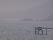
275-hectare (680-acre) island, bounded by Middle Slough, New York Slough, and Suisun Bay. On the left in photo.
|
| Canal Ranch Tract
|
|
|
|
|
| Coney Island
|

|
37°50′45″N 121°32′58″W / 37.8457598°N 121.5493939°W / 37.8457598; -121.5493939 (Coney Island)
|
Contra Costa
|
|
| Dead Horse Island
|

|
38°13′45″N 121°30′08″W / 38.2290821°N 121.5021750°W / 38.2290821; -121.5021750 (Dead Horse Island)
|
Sacramento
|
|
| Decker Island
|

|
38°05′26″N 121°43′09″W / 38.0904745°N 121.7191214°W / 38.0904745; -121.7191214 (Decker Island)
|
Solano
|
Small island on the top-left in photo.
|
| Empire Tract
|
|
|
|
|
| Fabian Tract
|
|
|
|
|
| Fay Island
|

|
37°56′55″N 121°33′55″W / 37.9485348°N 121.5652291°W / 37.9485348; -121.5652291 (Fay Island)
|
San Joaquin
|
|
| Glanville Tract
|
|
|
|
|
| Grand Island
|

|
38°14′08″N 121°34′45″W / 38.23556°N 121.57917°W / 38.23556; -121.57917 (Grand Island)
|
Sacramento
|
|
| Hastings Tract
|
|
|
|
|
| Holland Tract
|
|
|
|
|
| Hotchkiss Tract
|
|
|
|
|
| Jersey Island
|

|
38°02′11″N 121°41′09″W / 38.0363°N 121.6858°W / 38.0363; -121.6858 (Jersey Island)
|
Contra Costa
|
1,425-hectare (3,520-acre) island, bounded by False River, Piper Slough, Taylor Slough, Dutch Slough and San Joaquin River.
|
| Jones Tract
|

|
upper: 37°55′12″N 121°28′35″W / 37.9199°N 121.4763°W / 37.9199; -121.4763 (Upper Jones Tract)
lower:37°57′16″N 121°29′38″W / 37.9544°N 121.4938°W / 37.9544; -121.4938 (Lower Jones Tract) (lower)
|
San Joaquin
|
4,900-hectare (12,000-acre) island (tracts, Upper- and Lower-), bounded by Empire Cut, Whiskey Slough, Trapper Slough, and Middle River, 10 km east of Stockton
|
| King Island
|

|
38°03′56″N 121°26′12″W / 38.0655°N 121.4366°W / 38.0655; -121.4366 (King Island)
|
San Joaquin
|
1,300-hectare (3,200-acre) island bounded by White Slough, Bishop Cut, Disappointment Slough, and Honker Cut
|
| Kings Island
|

|
37°51′29″N 121°34′08″W / 37.8580°N 121.5688°W / 37.8580; -121.5688 (Kings Island)
|
Contra Costa
|
3.5-hectare (8.6-acre) island in Old River
|
| Little Mandeville Island
|

|
38°00′38″N 121°33′54″W / 38.0104776°N 121.5649522°W / 38.0104776; -121.5649522 (Little Mandeville Island)
|
San Joaquin
|
|
| Little Tinsley Island
|
|
|
|
|
| Mandeville Island
|

|
38°02′05″N 121°32′56″W / 38.03472°N 121.54889°W / 38.03472; -121.54889
|
San Joaquin
|
|
| McDonald Island
|

|
38°00′05″N 121°29′24″W / 38.0013°N 121.4900°W / 38.0013; -121.4900 (McDonald Island)
|
San Joaquin
|
2,400-hectare (5,900-acre) island, bounded by San Joaquin River, Middle River, Latham Slough, and Empire Cut.
|
| Medford Island
|

|
38°02′14″N 121°30′41″W / 38.0371435°N 121.5113407°W / 38.0371435; -121.5113407 (Medford Island)
|
San Joaquin
|
|
| Merritt Island
|
|
38°21′19″N 121°33′01″W / 38.3554°N 121.5503°W / 38.3554; -121.5503 (Merritt Island)
|
Yolo
|
A 5,000 acres (2,000 ha) island formed by the Sacramento River to the southeast and Elk Slough to the west, located directly across the Sacramento from Hood.
|
| Mildred Island
|

|
37°59′11″N 121°31′23″W / 37.9863117°N 121.5230069°W / 37.9863117; -121.5230069 (Mildred Island)
|
San Joaquin
|
|
| Netherlands Island
|
|
|
|
|
| Neville Island
|
|
|
|
|
| New Hope Tract
|
|
|
|
|
| Orwood Tract
|
|
|
|
|
| Palm Tract
|
|
|
|
|
| Pierson District
|
|
|
|
|
| Prospect Island
|

|
38°14′47″N 121°39′56″W / 38.2463030°N 121.6655110°W / 38.2463030; -121.6655110 (Prospect Island)
|
Solano
|
|
| Quimby Island
|

|
38°01′31″N 121°34′17″W / 38.0251993°N 121.5713413°W / 38.0251993; -121.5713413 (Quimby Island)
|
Contra Costa
|
|
| Rhode Island
|
|
37°59′59″N 121°34′31″W / 37.9996445°N 121.5752300°W / 37.9996445; -121.5752300 (Rhode Island)
|
Contra Costa
|
|
| Rindge Tract
|
|
|
|
|
| Rio Blanco Tract
|
|
|
|
|
| Roberts Island
|

|
37°54′18″N 121°23′07″W / 37.9049250°N 121.3852250°W / 37.9049250; -121.3852250 (Roberts Island)
|
San Joaquin
|
|
| Ruff and Ready Island
|
|
|
San Joaquin River
|
An approximately 2.3-square-mile island in Stockton, California. A United States Navy installation built there during World War II was phased out in 1995 and later transferred to the Port of Stockton.
|
| Ryer Island
|

|
38°14′26″N 121°38′03″W / 38.2405°N 121.6341°W / 38.2405; -121.6341 (Ryer Island)
|
Solano
|
4,750-hectare (11,700-acre), bounded by Miner Slough and Steamboat Slough.
|
| Sargent Barhart Tract
|
|
|
|
|
| Sherman Island
|

|
38°03′34″N 121°44′00″W / 38.0594°N 121.7333°W / 38.0594; -121.7333 (Sherman Island)
|
Sacramento
|
5,500-hectare (14,000-acre) island bounded by the Sacramento River, Three Mile Slough, and the San Joaquin River.
|
| Shima Tract
|
|
|
|
|
| Shin Kee Tract
|
|
|
|
|
| Staten Island
|

|
38°09′52″N 121°30′59″W / 38.1644°N 121.5163°W / 38.1644; -121.5163 (Staten Island)
|
San Joaquin
|
3,700-hectare (9,100-acre) island bounded and flanked by the North Mokelumne River and South Mokelumne River.
|
| Stewart Tract
|
|
|
|
|
| Sutter Island
|

|
38°17′29″N 121°35′35″W / 38.2913°N 121.5930°W / 38.2913; -121.5930 (Sutter Island)
|
Sacramento
|
Formed by Sacramento River to the northeast, Steamboat Slough to the southeast, and Sutter Slough to the west. Located across the Sacramento River from Paintersville.
|
| Sycamore Island
|
|
|
|
|
| Terminous Tract
|
|
|
|
|
| Twitchell Island
|

|
38°06′35″N 121°38′55″W / 38.1096°N 121.6486°W / 38.1096; -121.6486 (Twitchell Island)
|
Sacramento
|
3,000-hectare (7,400-acre), bounded by Seven Mile Slough, San Joaquin River, and Three Mile Slough
|
| Tyler Island
|

|
38°10′23″N 121°32′51″W / 38.1729725°N 121.5474531°W / 38.1729725; -121.5474531 (Tyler Island)
|
Sacramento
|
|
| Union Island
|

|
37°50′15″N 121°30′56″W / 37.8374268°N 121.5155042°W / 37.8374268; -121.5155042 (Union Island)
|
San Joaquin
|
|
| Van Sickle Island
|

|
38°04′00″N 121°54′04″W / 38.06667°N 121.90111°W / 38.06667; -121.90111 (Van Sickle Island)
|
Solano
|
|
| Veale Tract
|
|
|
|
|
| Venice Island
|

|
38°04′30″N 121°32′04″W / 38.0749°N 121.5344°W / 38.0749; -121.5344 (Venice Island)
|
San Joaquin
|
1,250-hectare (3,100-acre) island bounded by Potato Slough, Little Connection Slough, Stockton Deepwater Channel Venice Cut, and San Joaquin River.
|
| Victoria Island
|

|
37°53′24″N 121°32′05″W / 37.8899°N 121.5347°W / 37.8899; -121.5347 (Victoria Island)
|
San Joaquin
|
2,900-hectare (7,200-acre) island bounded by North Victoria Canal, Middle River, Victoria Canal, and Old River.
|
| Webb Tract
|
|
|
|
|
| West Island
|
|
38°01′24″N 121°46′43″W / 38.0233°N 121.7786°W / 38.0233; -121.7786 (West Island)
|
Sacramento
|
|
| Winter Island
|
|
38°02′32″N 121°50′55″W / 38.0421°N 121.8486°W / 38.0421; -121.8486 (Winter Island)
|
Contra Costa
|
On the right in photo.
|
| Woodward Island
|

|
37°55′42″N 121°32′46″W / 37.9283°N 121.5461°W / 37.9283; -121.5461 (Woodward Island)
|
San Joaquin
|
725-hectare (1,790-acre) island bounded by Bacon Island, Old River, Middle River, and Woodward Canal
|
| Wright-Elmwood Tract
|
|
|
|
|