The Mono–Inyo Craters are a volcanic chain of craters, domes and lava flows in Mono County, Eastern California. The chain stretches 25 miles (40 km) from the northwest shore of Mono Lake to the south of Mammoth Mountain. The Mono Lake Volcanic Field forms the northernmost part of the chain and consists of two volcanic islands in the lake and one cinder cone volcano on its northwest shore. Most of the Mono Craters, which make up the bulk of the northern part of the Mono–Inyo chain, are phreatic (steam explosion) volcanoes that have since been either plugged or over-topped by rhyolite domes and lava flows. The Inyo volcanic chain form much of the southern part of the chain and consist of phreatic explosion pits, and rhyolitic lava flows and domes. The southernmost part of the chain consists of fumaroles and explosion pits on Mammoth Mountain and a set of cinder cones south of the mountain; the latter are called the Red Cones.
The region has been used by humans for centuries. Obsidian was collected by Mono Paiutes for making sharp tools and arrow points. Glassy rock continues to be removed in modern times for use as commercial scour and yard decoration. Mono Mills processed timber felled on or near the volcanoes for the nearby boomtown Bodie in the late 19th to early 20th centuries. Water diversions into the Los Angeles Aqueduct system from their natural outlets in Mono Lake started in 1941 after a water tunnel was cut under the Mono Craters. Mono Lake Volcanic Field and a large part of the Mono Craters gained some protection under Mono Basin National Forest Scenic Area in 1984. Resource use along all of the chain is managed by the United States Forest Service as part of Inyo National Forest. Various activities are possible along the chain, including hiking, bird watching, canoeing, skiing, and mountain biking. (Full article...)
Paula Julie Abdul (born June 19, 1962) is an American singer, dancer, choreographer, actress, and television personality. She began her career as a cheerleader for the Los Angeles Lakers at the age of 18 and later became the head choreographer for the Laker Girls, where she was discovered by the Jacksons. After choreographing music videos for Janet Jackson, Abdul became a choreographer at the height of the music video era and soon thereafter she was signed to Virgin Records. Her debut studio album Forever Your Girl (1988) became one of the most successful debut albums at that time, selling seven million copies in the United States and setting a record for the most number-one singles from a debut album on the Billboard Hot 100 chart: "Straight Up", "Forever Your Girl", "Cold Hearted", and "Opposites Attract". Her second album Spellbound (1991) scored her two more chart-toppers – "Rush Rush" and "The Promise of a New Day". With six number-one singles on Hot 100, Abdul tied Diana Ross for the third-most chart-toppers among female solo artists at the time.
A graduate of the University of South Dakota and University of Minnesota, Lawrence obtained a PhD in physics at Yale in 1925. In 1928, he was hired as an associate professor of physics at the University of California, Berkeley, becoming the youngest full professor there two years later. In its library one evening, Lawrence was intrigued by a diagram of an accelerator that produced high-energy particles. He contemplated how it could be made compact, and came up with an idea for a circular accelerating chamber between the poles of an electromagnet. The result was the first cyclotron. (Full article...)
Image 4
Jack Leonard Warner (born Jacob Warner; August 2, 1892 – September 9, 1978) was a Canadian-American film executive, who was the president and driving force behind the Warner Bros. Studios in Burbank, California. Warner's career spanned over 55 years, surpassing that of any other of the seminal Hollywood studio moguls.
As co-head of production at Warner Bros. Studios, Warner worked with his brother, Sam Warner, to procure the technology for the film industry's first talking picture, The Jazz Singer (1927). After Sam's death, Jack clashed with his surviving older brothers, Harry and Albert Warner. He assumed exclusive control of the company in the 1950s when he secretly purchased his brothers's shares in the business after convincing them to participate in a joint sale of stocks. (Full article...)
Joshua Abraham Norton (February 4, 1818 – January 8, 1880) was a resident of San Francisco, California, who in 1859 proclaimed himself"Norton I., Emperor of the United States", commonly known as Emperor Norton. In 1863, after Napoleon IIIinvaded Mexico, he took the secondary title of "Protector of Mexico".
For the first few years after arriving in San Francisco in 1849, Norton made a successful living as a commodities trader and real estate speculator. However, he was financially ruined following a failed bid to corner the rice market during a shortage prompted by a famine in China. He bought a shipload of Peruvian rice at 12 cents per pound (26 ¢/kg), but more Peruvian ships arrived in port, causing the price to drop sharply to three cents per pound (6.6 ¢/kg). He then lost a protracted lawsuit in which he tried to void his rice contract, and his local prominence faded. (Full article...)
Born and raised in Los Angeles, Monroe spent most of her childhood in a total of 12 foster homes and an orphanage before marrying James Dougherty at age sixteen. She was working in a factory during World War II when she met a photographer from the First Motion Picture Unit and began a successful pin-up modeling career, which led to short-lived film contracts with 20th Century Fox and Columbia Pictures. After a series of minor film roles, she signed a new contract with Fox in late 1950. Over the next two years, she became a popular actress with roles in several comedies, including As Young as You Feel and Monkey Business, and in the dramas Clash by Night and Don't Bother to Knock. Monroe faced a scandal when it was revealed that she had posed for nude photographs prior to becoming a star, but the story did not damage her career and instead resulted in increased interest in her films. (Full article...)
Image 9
London in 1903
John Griffith Chaney (January 12, 1876 – November 22, 1916), better known as Jack London, was an American novelist, journalist and activist. A pioneer of commercial fiction and American magazines, he was one of the first American authors to become an international celebrity and earn a large fortune from writing. He was also an innovator in the genre that would later become known as science fiction.
Ruth E. Norman (born Ruth Nields; August 18, 1900 – July 12, 1993), also known as Uriel, was an American religious leader who co-founded the Unarius Academy of Science, based in Southern California. Raised in California, Norman received little education and worked from an early age in a variety of jobs. In the 1940s, she developed an interest in psychic phenomena and past-life regression. These pursuits led to her introduction to Ernest Norman, a self-described psychic, in 1954. He engaged in channeling, past-life regression, and attempts at communication with extraterrestrials. She married Ernest, her fourth husband, in the mid-1950s. Together they published several books about his revelations and formed Unarius, an organization which later became known as the Unarius Academy of Science, to popularize his teachings. The couple discussed numerous details about their alleged past lives and spiritual visits to other planets, forming a mythology from these accounts.
After Ernest died in 1971, Ruth succeeded him as their group's leader and primary channeler. She subsequently began publishing accounts of her experiences and revelations. In early 1974, she predicted that a space fleet of benevolent extraterrestrials, the Space Brothers, would land on Earth later that year, which led the Unarius Academy to purchase a property to serve as the landing site. After the extraterrestrials failed to appear, Norman said that trauma she had suffered in a past life had caused her to make an inaccurate prediction. Undaunted, she rented a building for Unarius' meetings and sought publicity for the movement, claiming to have united the Earth with an interplanetary confederation. She revised the Space Brothers' expected landing date several times, before finally settling on 2001. Her health declined in the late 1980s, prompting her students to try to heal her with rituals of past-life regression. Despite predicting that she would live to see the extraterrestrials land, Norman died in 1993. Unarius has continued to operate after her death, and formed a board of directors. Since the 2000s, leaders have concentrated on individual transformation leading to spiritual change in humankind. (Full article...)
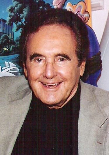
Image 11
Hartman in character as Chick Hazard, Private Eye, circa 1978.
Michael Joseph Jackson (August 29, 1958 – June 25, 2009) was an American singer, songwriter, dancer, and philanthropist. Known as the "King of Pop", he is regarded as one of the most significant cultural figures of the 20th century. During his four-decade career, his contributions to music, dance, and fashion, along with his publicized personal life, made him a global figure in popular culture. Jackson influenced artists across many music genres. Through stage and video performances, he popularized complicated street dance moves such as the moonwalk, which he named, as well as the robot.
Born in Los Angeles, DiCaprio began his career in the late 1980s by appearing in television commercials. In the early 1990s, he had recurring roles in various television shows, such as the sitcom Parenthood, and had his first major film part as author Tobias Wolff in This Boy's Life (1993). He received critical acclaim and his first Academy Award and Golden Globe Award nominations for his performance as a developmentally disabled boy in What's Eating Gilbert Grape (1993). DiCaprio achieved international stardom with the star-crossed romances Romeo + Juliet (1996) and Titanic (1997). After the latter became the highest-grossing film in the world at the time, he reduced his workload for a few years. In an attempt to shed his image of a romantic hero, DiCaprio sought roles in other genres, including the 2002 crime dramas Catch Me If You Can and Gangs of New York; the latter marked the first of his many successful collaborations with director Martin Scorsese. (Full article...)
... that KICU-TV in Visalia, California, claimed to be the most powerful TV station west of the Mississippi River after a transmitter upgrade—and closed for good two years later?
... that Bull Island was farmed by the Money family for over 100 years before being turned into a wildlife preserve?
... that an FCC hearing examiner scolded the owner of California radio station KCTY for having a "cavalier attitude" and at times being too lazy to put the station on the air?
Barker Dam is a water-storage facility located in Joshua Tree National Park in California. The dam was constructed by early cattlemen, and is situated between Queen Valley and the Wonderland of Rocks near the Wall Street Mill. It is a gathering place for desert wildlife, including many species of birds and Desert Bighorn Sheep.
This is a list of recognized content, updated weekly by JL-Bot (talk·contribs) (typically on Saturdays). There is no need to edit the list yourself. If an article is missing from the list, make sure it is tagged (e.g. {{WikiProject California}}) or categorized correctly and wait for the next update. See WP:RECOG for configuration options.