Redistricting in Oklahoma after the 2020 census
Redistricting is the process of enacting new district boundaries for elected offices, particularly for offices in the U.S. House of Representatives and state legislatures. This article chronicles the 2020 redistricting cycle in Oklahoma.
Gov. Kevin Stitt (R) signed a new congressional map into law on November 22, 2021. [1] On November 17, 2021, the Oklahoma House of Representatives voted 75-19 to approve the map.[2] On November 19, 2021, the Oklahoma State Senate voted to approve the map 36-10.[3]This map took effect for Oklahoma's 2022 congressional elections.
Gov. Kevin Stitt (R) signed new legislative maps into law on November 22, 2021.[1] The Senate approved the Senate map in a 46-1 vote on November 17, 2021, and the House approved the Senate map 95-1 on November 19, 2021.[4] The House approved the House map 88-3 on November 17, 2021, and the Senate approved the House map 44-2 on November 19, 2021.[5]These maps took effect for Oklahoma's 2022 legislative elections.
Click here for more information.
Oklahoma's five United States representatives and 149 state legislators are all elected from political divisions called districts. District lines are redrawn every 10 years following completion of the United States census. Federal law stipulates that districts must have nearly equal populations and must not discriminate on the basis of race or ethnicity.
See the sections below for further information on the following topics:
- Summary: This section provides summary information about the drafting and enacting processes.
- Apportionment and release of census data: This section details the 2020 apportionment process, including data from the United States Census Bureau.
- Drafting process: This section details the drafting process for new congressional and state legislative district maps.
- Enactment: This section provides information about the enacted congressional and state legislative district maps.
- Court challenges: This section details court challenges to the enacted congressional and state legislative district maps.
- Background: This section summarizes federal and state-based requirements for redistricting at both the congressional and state legislative levels. A summary of the 2010 redistricting cycle in Oklahoma is also provided.
Timeline
This section lists major events in the post-2020 census redistricting cycle in reverse chronological order. Major events include the release of apportionment data, the release of census population data, the introduction of formal map proposals, the enactment of new maps, and noteworthy court challenges. Click the dates below for additional information.
- November 22, 2021: Governor Kevin Stitt (R) signed new congressional and legislative maps into law.
- November 19, 2021: The Oklahoma State Senate voted to approve the congressional map 36-10. The Senate also voted 44-2 to approve the House map, and the House voted 95-1 to approve the Senate map.
- November 17, 2021: The Oklahoma House of Representatives voted 75-19 to approve the congressional map. The House also voted 88-3 to approve the House map, and the Senate voted 46-1 to approve the Senate map.
- November 15, 2021: The Oklahoma State Legislature began a special session to discuss redistricting.
- November 1, 2021: State lawmakers released their first congressional map proposal and new legislative proposals drawn using census data.
- September 16, 2021: The U.S. Census Bureau released data from the 2020 census in an easier-to-use format to state redistricting authorities and the public.
- August 23, 2021: Members of the House and Senate redistricting committees announced the legislative maps would need to be redrawn using 2020 census data.
- August 12, 2021: The U.S. Census Bureau delivered redistricting data to states in a legacy format.
- May 13, 2021: Gov. Kevin Stitt (R) signed new legislative maps into law.
- April 26, 2021: The U.S. Census Bureau delivered apportionment counts. Oklahoma was apportioned five seats in the U.S. House of Representatives. This represented neither a gain nor a loss of seats as compared to apportionment after the 2010 census.
- April 21, 2021: State lawmakers in Oklahoma released their proposed maps for the Oklahoma State Senate and the Oklahoma House of Representatives, becoming the first state in the 2020 redistricting cycle to produce draft maps.
Enactment
Enacted congressional district maps
Gov. Kevin Stitt (R) signed a new congressional map into law on November 22, 2021. [1] On November 17, 2021, the Oklahoma House of Representatives voted 75-19 to approve the map.[6] On November 19, 2021, the Oklahoma State Senate voted to approve the map 36-10.[7]This map took effect for Oklahoma's 2022 congressional elections.
Below are the congressional maps in effect before and after the 2020 redistricting cycle.
Oklahoma Congressional Districts
until January 2, 2023
Click a district to compare boundaries.
Oklahoma Congressional Districts
starting January 3, 2023
Click a district to compare boundaries.
2020 presidential results
The table below details the results of the 2020 presidential election in each district at the time of the 2022 election and its political predecessor district.[8] This data was compiled by Daily Kos Elections.[9]
| 2020 presidential results by Congressional district, Oklahoma | ||||
|---|---|---|---|---|
| District | 2022 district | Political predecessor district | ||
| Joe Biden |
Donald Trump |
Joe Biden |
Donald Trump | |
| Oklahoma's 1st | 38.0% | 59.4% | 37.3% | 60.1% |
| Oklahoma's 2nd | 22.4% | 75.8% | 22.1% | 76.1% |
| Oklahoma's 3rd | 26.5% | 71.2% | 23.1% | 74.6% |
| Oklahoma's 4th | 33.0% | 64.6% | 32.0% | 65.6% |
| Oklahoma's 5th | 40.3% | 57.1% | 46.0% | 51.3% |
Enacted state legislative district maps
Gov. Kevin Stitt (R) signed new legislative maps into law on November 22, 2021.[1] The Senate approved the Senate map in a 46-1 vote on November 17, 2021, and the House approved the Senate map 95-1 on November 19, 2021.[10] The House approved the House map 88-3 on November 17, 2021, and the Senate approved the House map 44-2 on November 19, 2021.[11]These maps took effect for Oklahoma's 2022 legislative elections.
State Senate map
Below is the state Senate map in effect before and after the 2020 redistricting cycle.
Oklahoma State Senate Districts
until November 22, 2022
Click a district to compare boundaries.
Oklahoma State Senate Districts
starting November 23, 2022
Click a district to compare boundaries.
State House map
Below is the state House map in effect before and after the 2020 redistricting cycle.
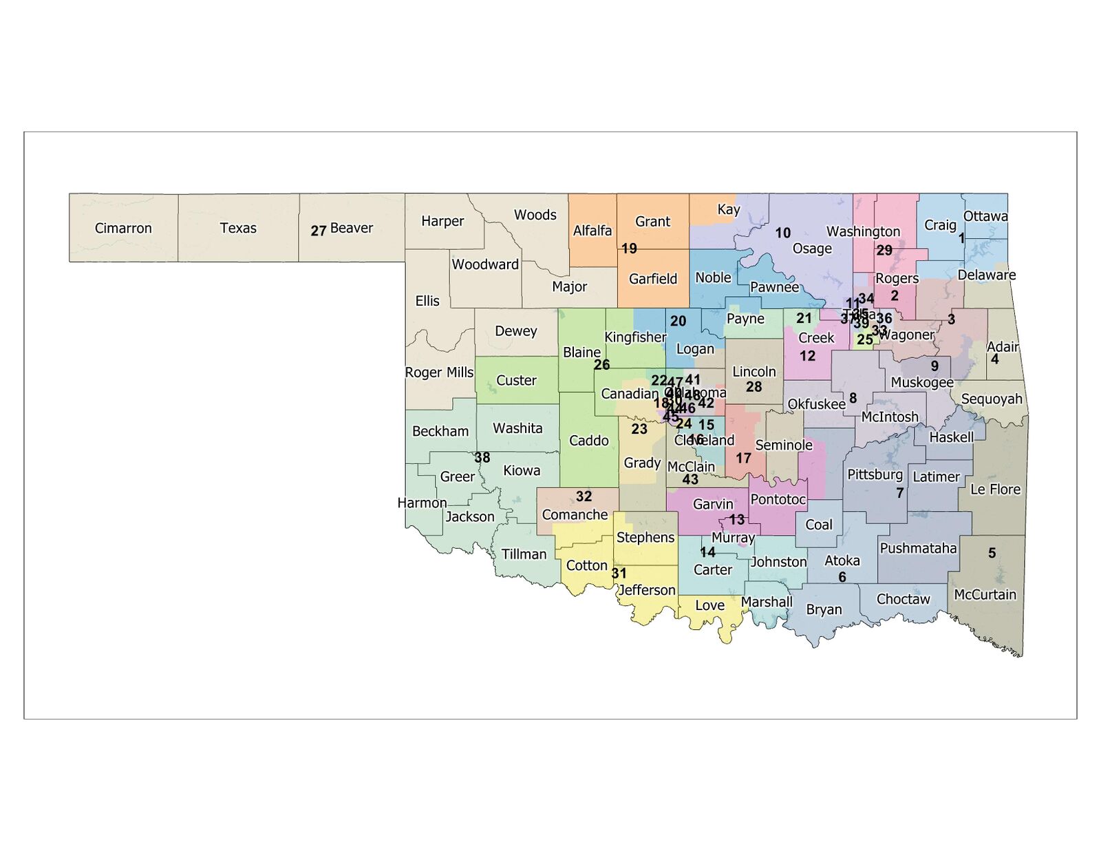
Oklahoma State House Districts
until November 22, 2022
Click a district to compare boundaries.
Oklahoma State House Districts
starting November 23, 2022
Click a district to compare boundaries.
Reactions
After signing the maps into law, Governor Kevin Stitt (R) said: "Following an open and transparent process that included public input, these maps were passed with majority support in both the House and the Senate and I am pleased to execute the will of Oklahomans by signing these new maps into law."[1] Rep. Collin Walke (D) criticized the congressional map, saying: "While I have no doubt that somebody wasn’t sitting there looking at the numbers of Democrats versus Republicans while literally drawing this map, I think we’d all be naive to assume that there weren’t political influences outside of this building dictating what happens inside of this building." Rep. John Pfeiffer (R) supported the map, saying: "We do like to fight about the change and the things that have changed. But the truth be told, although our population has increased, this map hasn’t changed that much."[12]
Enacted state legislative district maps (May 2021)
New state Senate and state House district maps were signed into law by Governor Kevin Stitt (R) on May 13, 2021.[13] On Aug. 23, the House and Senate redistricting committee chairs announced the first round of enacted maps would have to be redrawn following the release of 2020 census data.[14]
Images of the enacted Senate and House maps are embedded below.
Drafting process
In Oklahoma, both congressional and state legislative district boundaries are drawn by the Oklahoma State Legislature. These lines may be vetoed by the governor.[15]
If the legislature is unable to approve a state legislative redistricting plan, a backup commission must draw the lines. The commission comprises the following seven members:[15]
- The governor appoints one Republican and one Democrat.
- The majority leader of the Oklahoma State Senate appoints one Republican and one Democrat.
- The majority leader of the Oklahoma House of Representatives appoints one Republican and one Democrat.
- The lieutenant governor serves as the non-voting chair of the commission.
The Oklahoma Constitution requires that state Senate district boundaries take into account "population, compactness, area, political units, historical precedents, economic and political interests, contiguous territory, and other major factors."[15]
The redistricting committee of the state House adopted redistricting guidelines similar to the senatorial district requirements described above. These guidelines apply to state House and congressional districts, as well. These guidelines may be amended by the state legislature at its discretion.[15]
Timeline
The Oklahoma House of Representatives provided this projected timeline for the 2020 redistricting cycle in Oklahoma.[16] On Sept. 24, Gov. Kevin Stitt (R) called a special session of the legislature to address redistricting that began Nov. 15, 2021.[17]
| Projected redistricting timeline for Oklahoma, 2020 cycle | |
|---|---|
| Date | Event |
| April 1, 2020 | Census Day |
| October 15, 2020 | Revised deadline for Census to complete collection activities |
| November 3, 2020 | General Election: Last election to be held using the current district boundaries for the state House, Senate, and Congressional seats |
| December 11, 2020 | Bill request deadline for the First Regular Session of the 58th Legislature |
| January 5, 2021 | 58th Legislature convenes for Organizational Day |
| February 1, 2021 | Legislature reconvenes |
| April 1, 2021 | Deadline for Census to deliver P.L. 94-171 redistricting data to states |
| May 28, 2021 | Sine die adjournment deadline |
| April 15, 2022 | Filing deadline for 2022 primary elections for federal, state, and legislative offices |
| June 28, 2022 | Primary Election: First election to be held using the new district boundaries for state House, Senate, and Congressional seats |
Committees and/or commissions involved in the process
In Oklahoma, the following committees are involved in the redistricting process: the House Redistricting Committee and Senate Redistricting Committee. As of January 7, 2021, these committees had the following members:[18][19]
| Oklahoma Senate Redistricting Committee membership, 2020 cycle | |
|---|---|
| Name | Partisan affiliation |
| Chairman Sen. Lonnie Paxton | |
| Co-vice Chairman Sen. Dave Rader | |
| Co-vice Chairman Sen. Michael Brooks | |
| Sen. Julie Daniels | |
| Sen. George Burns | |
| Sen. Dewayne Pemberton | |
| Sen. Casey Murdock | |
| Sen. Bill Coleman | |
| Sen. John Montgomery | |
| Sen. Frank Simpson | |
| Sen. Adam Pugh | |
| Sen. Kevin Matthews | |
| Sen. Julia Kirt | |
| Oklahoma House Redistricting Committee membership, 2020 cycle | |
|---|---|
| Name | Partisan affiliation |
| Chairman Rep. Ryan Martinez | |
| Co-vice Chairman Rep. Brad Boles | |
| Co-vice Chairman Rep. Emily Virgin | |
All members of the Oklahoma House of Representatives were assigned to regional redistricting subcommittees. The subcommittees and members can be found in the tables below.
- Northwest Oklahoma Subcommittee membership, 2020 cycle
Northwest Oklahoma Subcommittee membership, 2020 cycle Name Partisan affiliation Chairman Rep. Carl Newton Republican
Vice-Chairman Rep. Brian Hill Rep. Denise Hader Rep. Jay Steagall Rep. Todd Russ Rep. Anthony Moore Rep. Mike Dobrinski Rep. Rhonda Baker Rep. Kenton Patzkowsky
- North Central Oklahoma Subcommittee membership, 2020 cycle
North Central Oklahoma Subcommittee membership, 2020 cycle Name Partisan affiliation Chairman Rep. Ty Burns Vice-Chairman Rep. John Talley Rep. Judd Strom Rep. Kyle Hilbert Rep. Mark Lawson Rep. Garry Mize Rep. Kevin Wallace Rep. Trish Ranson Democrat
Rep. Sean Roberts Rep. Ken Luttrell Rep. John Pfeiffer Rep. Chad Caldwell
- Northeast Oklahoma Subcommittee membership, 2020 cycle
Northeast Oklahoma Subcommittee membership, 2020 cycle Name Partisan affiliation Chairman Rep. Jim Olsen Vice-Chairman Rep. Rusty Cornwell Rep. Bob Ed Culver Rep. Josh West Rep. Steve Bashore Rep. Tom Gann Rep. Mark Lepak Rep. Wendi Stearman Rep. Kevin McDugle Rep. Avery Carl Frix Rep. Chris Sneed Rep. Scott Fetgatter Rep. Logan Phillips Rep. David Hardin
- Oklahoma City Subcommittee membership, 2020 cycle
Oklahoma City Subcommittee membership, 2020 cycle Name Partisan affiliation Chairwoman Rep. Nicole Miller Vice-Chairman Rep. Ajay Pittman Rep. Ryan Martinez Rep. Mike Osburn Rep. Eric Roberts Rep. Tammy West Rep. Cyndi Munson Rep. Collin Walke Rep. Mauree Turner Rep. Jose Cruz Rep. Jon Echols Rep. Forrest Bennett Rep. Mickey Dollens Rep. Andy Fugate Rep. Max Wolfley Rep. Preston Stinson Rep. Jason Lowe Rep. Marilyn Stark Rep. Robert Manger
- Southwest Oklahoma Subcommittee membership, 2020 cycle
Southwest Oklahoma Subcommittee membership, 2020 cycle Name Partisan affiliation Chairman Rep. Trey Caldwell Vice-Chairwoman Rep. Toni Hasenbeck Rep. Marcus McEntire Rep. Brad Boles Rep. Gerrid Kendrix Rep. Dick Lowe Rep. Daniel Pae Rep. Rande Worthen
- South Central Oklahoma Subcommittee membership, 2020 cycle
South Central Oklahoma Subcommittee membership, 2020 cycle Name Partisan affiliation Chairwoman Rep. Tammy Townley Vice-Chairman Rep. Ronny Johns Rep. Sherrie Conley Rep. Charles McCall Rep. Dell Kerbs Rep. Danny Sterling Rep. Danny Williams Rep. Cynthia Roe Rep. Emily Virgin Rep. Merleyn Bell Rep. Jacob Rosecrants Rep. Tommy Hardin Rep. Mark McBride Rep. Kevin West Rep. Chris Kannady
- Southeast Oklahoma Subcommittee membership, 2020 cycle
Southeast Oklahoma Subcommittee membership, 2020 cycle Name Partisan affiliation Chairman Rep. Randy Randleman Vice-Chairman Rep. Jim Grego Rep. Eddy Dempsey Rep. Rick West Rep. David Smith Rep. Justin JJ Humphrey Rep. Dustin Roberts
- Tulsa Subcommittee membership, 2020 cycle
Tulsa Subcommittee membership, 2020 cycle Name Partisan affiliation Chairwoman Rep. Sheila Dills Vice-Chairman Rep. Monroe Nichols Rep. Terry O'Donnell Rep. Jadine Nollan Rep. Jeff Boatman Rep. Lonnie Sims Rep. Carol Bush Rep. Denise Brewer Rep. Regina Goodwin Rep. Mark Vancuren Rep. T.J. Marti Rep. Ross Ford Rep. John Waldron Rep. Meloyde Blancett Rep. Melissa Provenzano Rep. Stan May Rep. Dean Davis
Drafts and proposals
Congressional district maps
On November 1, state lawmakers released proposed congressional maps.[20]
Legislative district maps (November 2021)
On November 1, state lawmakers released new proposed maps for the Oklahoma State Senate and the Oklahoma House of Representatives, which were drawn using 2020 census data.[20]
Legislative district maps (April 2021)
On April 21, 2021, state lawmakers in Oklahoma released their proposed maps for the Oklahoma State Senate and the Oklahoma House of Representatives, becoming the first state in the 2020 redistricting cycle to produce draft maps. In lieu of final 2020 census data, which had not been made available to the states as of April 21, 2021, lawmakers used the U.S. Census Bureau’s American Community Survey data for 2015 through 2019 to draft their proposals.[21]
Proposed maps compared to ideal district populations
An ideal district population is equal to a state's population divided by the number of districts. Under U.S. Supreme Court precedent, the populations of different state legislative districts can vary within a 10-percent range. For example, if the overall population deviation for a proposed map was four percent, this could mean that the population of at least one district was two percent lower than the ideal, and the population of at least one district was two percent higher than the ideal.
Oklahoma House of Representatives: According to ACS data, the ideal Oklahoma House district population was 38,939. The overall population deviation for the proposed House map was 3.77 percent, ranging from 1.91 percent below to 1.85 percent above the ideal district population.
Oklahoma State Senate: According to ACS data, the ideal Oklahoma Senate district population was 81,935, with an overall population deviation of 3.84 percent, ranging from 1.87 percent below to 1.97 percent above the ideal district population.[22][23]
Map images
Images of the proposed statewide maps are embedded below.
- Click here for an interactive viewer of the proposed maps.
- Click here for individual Senate district maps, public submissions, and other documents.
- Click here for individual House district maps, public submissions, and other documents.
Reactions
Upon announcing the release of the proposed Senate map, Sen. Lonnie Paxton (R), chair of the Senate Select Committee on Redistricting, said, "Throughout the process, the Senate has operated openly and transparently. We held 22 town hall meetings, both virtual and in-person, across Oklahoma in coordination with the House. We sought public input at every stage, including accepting public map submissions, and shared those results through our website. Because of the open and transparent redistricting process, the Senate district maps this year are more compact and better by most criteria than the 2010 district maps."[23]
Rick Hasen, a law professor at the University of California (Irvine), criticized the proposed maps: "The state house map has an expected pro-Republican efficiency gap of 13%, remaining in double digits in almost any electoral environment. The state senate map has an expected pro-Republican efficiency gap of 15%, also remaining in double digits in essentially all electoral conditions. These are staggeringly bad scores, at the outer edge of the historical distribution. They’re a preview of the ruthless gerrymandering we’re likely to see this cycle in states with single-party control of redistricting."[24]
Apportionment and release of census data
Apportionment is the process by which representation in a legislative body is distributed among its constituents. The number of seats in the United States House of Representatives is fixed at 435. The United States Constitution dictates that districts be redrawn every 10 years to ensure equal populations between districts. Every ten years, upon completion of the United States census, reapportionment occurs.[25]
Apportionment following the 2020 census
The U.S. Census Bureau delivered apportionment counts on April 26, 2021. Oklahoma was apportioned five seats in the U.S. House of Representatives. This represented neither a gain nor a loss of seats as compared to apportionment after the 2010 census.[26]
See the table below for additional details.
| 2020 and 2010 census information for Oklahoma | |||||||
|---|---|---|---|---|---|---|---|
| State | 2010 census | 2020 census | 2010-2020 | ||||
| Population | U.S. House seats | Population | U.S. House seats | Raw change in population | Percentage change in population | Change in U.S. House seats | |
| Oklahoma | 3,764,882 | 5 | 3,963,516 | 5 | 198,634 | 5.28% | 0 |
Redistricting data from the Census Bureau
On February 12, 2021, the Census Bureau announced that it would deliver redistricting data to the states by September 30, 2021. On March 15, 2021, the Census Bureau released a statement indicating it would make redistricting data available to the states in a legacy format in mid-to-late August 2021. A legacy format presents the data in raw form, without data tables and other access tools. On May 25, 2021, Ohio Attorney General Dave Yost (R) announced that the state had reached a settlement agreement with the Census Bureau in its lawsuit over the Census Bureau's timetable for delivering redistricting data. Under the terms of the settlement, the Census Bureau agreed to deliver redistricting data, in a legacy format, by August 16, 2021.[27][28][29][30] The Census Bureau released the 2020 redistricting data in a legacy format on August 12, 2021, and in an easier-to-use format at data.census.gov on September 16, 2021.[31][32]
Court challenges
- If you are aware of any relevant lawsuits that are not listed here, please email us at editor@ballotpedia.org.
This section will include information regarding legal challenges to enacted maps.
Background
This section includes background information on federal requirements for congressional redistricting, state legislative redistricting, state-based requirements, redistricting methods used in the 50 states, gerrymandering, and recent court decisions.
Federal requirements for congressional redistricting
According to Article I, Section 4 of the United States Constitution, the states and their legislatures have primary authority in determining the "times, places, and manner" of congressional elections. Congress may also pass laws regulating congressional elections.[33][34]
| “ | The Times, Places and Manner of holding Elections for Senators and Representatives, shall be prescribed in each State by the Legislature thereof; but the Congress may at any time by Law make or alter such Regulations, except as to the Places of chusing Senators.[35] | ” |
| —United States Constitution | ||
Article I, Section 2 of the United States Constitution stipulates that congressional representatives be apportioned to the states on the basis of population. There are 435 seats in the United States House of Representatives. Each state is allotted a portion of these seats based on the size of its population relative to the other states. Consequently, a state may gain seats in the House if its population grows or lose seats if its population decreases, relative to populations in other states. In 1964, the United States Supreme Court ruled in Wesberry v. Sanders that the populations of House districts must be equal "as nearly as practicable."[36][37][38]
The equal population requirement for congressional districts is strict. According to All About Redistricting, "Any district with more or fewer people than the average (also known as the 'ideal' population), must be specifically justified by a consistent state policy. And even consistent policies that cause a 1 percent spread from largest to smallest district will likely be unconstitutional."[38]
Federal requirements for state legislative redistricting
The United States Constitution is silent on the issue of state legislative redistricting. In the mid-1960s, the United States Supreme Court issued a series of rulings in an effort to clarify standards for state legislative redistricting. In Reynolds v. Sims, the court ruled that "the Equal Protection Clause [of the United States Constitution] demands no less than substantially equal state legislative representation for all citizens, of all places as well as of all races." According to All About Redistricting, "it has become accepted that a [redistricting] plan will be constitutionally suspect if the largest and smallest districts [within a state or jurisdiction] are more than 10 percent apart."[38]
State-based requirements
In addition to the federal criteria noted above, individual states may impose additional requirements on redistricting. Common state-level redistricting criteria are listed below.
- Contiguity refers to the principle that all areas within a district should be physically adjacent. A total of 49 states require that districts of at least one state legislative chamber be contiguous (Nevada has no such requirement, imposing no requirements on redistricting beyond those enforced at the federal level). A total of 23 states require that congressional districts meet contiguity requirements.[38][39]
- Compactness refers to the general principle that the constituents within a district should live as near to one another as practicable. A total of 37 states impose compactness requirements on state legislative districts; 18 states impose similar requirements for congressional districts.[38][39]
- A community of interest is defined by FairVote as a "group of people in a geographical area, such as a specific region or neighborhood, who have common political, social or economic interests." A total of 24 states require that the maintenance of communities of interest be considered in the drawing of state legislative districts. A total of 13 states impose similar requirements for congressional districts.[38][39]
- A total of 42 states require that state legislative district lines be drawn to account for political boundaries (e.g., the limits of counties, cities, and towns). A total of 19 states require that similar considerations be made in the drawing of congressional districts.[38][39]
Methods
In general, a state's redistricting authority can be classified as one of the following:[40]
- Legislature-dominant: In a legislature-dominant state, the legislature retains the ultimate authority to draft and enact district maps. Maps enacted by the legislature may or may not be subject to gubernatorial veto. Advisory commissions may also be involved in the redistricting process, although the legislature is not bound to adopt an advisory commission's recommendations.
- Commission: In a commission state, an extra-legislative commission retains the ultimate authority to draft and enact district maps. A non-politician commission is one whose members cannot hold elective office. A politician commission is one whose members can hold elective office.
- Hybrid: In a hybrid state, the legislature shares redistricting authority with a commission.
Gerrymandering
- See also: Gerrymandering
The term gerrymandering refers to the practice of drawing electoral district lines to favor one political party, individual, or constituency over another. When used in a rhetorical manner by opponents of a particular district map, the term has a negative connotation but does not necessarily address the legality of a challenged map. The term can also be used in legal documents; in this context, the term describes redistricting practices that violate federal or state laws.[41][42]
For additional background information about gerrymandering, click "[Show more]" below.
The phrase racial gerrymandering refers to the practice of drawing electoral district lines to dilute the voting power of racial minority groups. Federal law prohibits racial gerrymandering and establishes that, to combat this practice and to ensure compliance with the Voting Rights Act, states and jurisdictions can create majority-minority electoral districts. A majority-minority district is one in which a racial group or groups comprise a majority of the district's populations. Racial gerrymandering and majority-minority districts are discussed in greater detail in this article.[43]
The phrase partisan gerrymandering refers to the practice of drawing electoral district maps with the intention of favoring one political party over another. In contrast with racial gerrymandering, on which the Supreme Court of the United States has issued rulings in the past affirming that such practices violate federal law, the high court had not, as of November 2017, issued a ruling establishing clear precedent on the question of partisan gerrymandering. Although the court has granted in past cases that partisan gerrymandering can violate the United States Constitution, it has never adopted a standard for identifying or measuring partisan gerrymanders. Partisan gerrymandering is described in greater detail in this article.[44][45]Recent court decisions
The Supreme Court of the United States has, in recent years, issued several decisions dealing with redistricting policy, including rulings relating to the consideration of race in drawing district maps, the use of total population tallies in apportionment, and the constitutionality of independent redistricting commissions. The rulings in these cases, which originated in a variety of states, impact redistricting processes across the nation.
For additional background information about these cases, click "[Show more]" below.
Alexander v. South Carolina State Conference of the NAACP (2024)
Alexander v. South Carolina State Conference of the NAACP — This case concerns a challenge to the congressional redistricting plan that the South Carolina legislature enacted after the 2020 census. In January 2023, a federal three-judge panel ruled that the state's 1st Congressional District was unconstitutional and enjoined the state from conducting future elections using its district boundaries. The panel's opinion said, "The Court finds that race was the predominant factor motivating the General Assembly’s adoption of Congressional District No. 1...Defendants have made no showing that they had a compelling state interest in the use of race in the design of Congressional District No. 1 and thus cannot survive a strict scrutiny review."[46] Thomas Alexander (R)—in his capacity as South Carolina State Senate president—appealed the federal court's ruling, arguing: :In striking down an isolated portion of South Carolina Congressional District 1 as a racial gerrymander, the panel never even mentioned the presumption of the General Assembly’s “good faith.”...The result is a thinly reasoned order that presumes bad faith, erroneously equates the purported racial effect of a single line in Charleston County with racial predominance across District 1, and is riddled with “legal mistake[s]” that improperly relieved Plaintiffs of their “demanding” burden to prove that race was the “predominant consideration” in District 1.[47] The U.S. Supreme Court scheduled oral argument on this case for October 11, 2023.[48]
Moore v. Harper (2023)
- See also: Moore v. Harper
At issue in Moore v. Harper, was whether state legislatures alone are empowered by the Constitution to regulate federal elections without oversight from state courts, which is known as the independent state legislature doctrine. On November 4, 2021, the North Carolina General Assembly adopted a new congressional voting map based on 2020 Census data. The legislature, at that time, was controlled by the Republican Party. In the case Harper v. Hall (2022), a group of Democratic Party-affiliated voters and nonprofit organizations challenged the map in state court, alleging that the new map was a partisan gerrymander that violated the state constitution.[49] On February 14, 2022, the North Carolina Supreme Court ruled that the state could not use the map in the 2022 elections and remanded the case to the trial court for further proceedings. The trial court adopted a new congressional map drawn by three court-appointed experts. The United States Supreme Court affirmed the North Carolina Supreme Court's original decision in Moore v. Harper that the state's congressional district map violated state law. In a 6-3 decision, Chief Justice John Roberts wrote that the "Elections Clause does not vest exclusive and independent authority in state legislatures to set the rules regarding federal elections.[50]
Merrill v. Milligan (2023)
- See also: Merrill v. Milligan
At issue in Merrill v. Milligan, was the constitutionality of Alabama's 2021 redistricting plan and whether it violated Section 2 of the Voting Rights Act. A group of Alabama voters and organizations sued Secretary of State John Merrill (R) and the House and Senate redistricting chairmen, Rep. Chris Pringle (R) and Sen. Jim McClendon (R). Plaintiffs alleged the congressional map enacted on Nov. 4, 2021, by Gov. Kay Ivey (R) unfairly distributed Black voters. The plaintiffs asked the lower court to invalidate the enacted congressional map and order a new map with instructions to include a second majority-Black district. The court ruled 5-4, affirming the lower court opinion that the plaintiffs showed a reasonable likelihood of success concerning their claim that Alabama's redistricting map violated Section 2 of the Voting Rights Act.[51]
Gill v. Whitford (2018)
- See also: Gill v. Whitford
In Gill v. Whitford, decided on June 18, 2018, the Supreme Court of the United States ruled that the plaintiffs—12 Wisconsin Democrats who alleged that Wisconsin's state legislative district plan had been subject to an unconstitutional gerrymander in violation of the First and Fourteenth Amendments—had failed to demonstrate standing under Article III of the United States Constitution to bring a complaint. The court's opinion, penned by Chief Justice John Roberts, did not address the broader question of whether partisan gerrymandering claims are justiciable and remanded the case to the district court for further proceedings. Roberts was joined in the majority opinion by Associate Justices Anthony Kennedy, Ruth Bader Ginsburg, Stephen Breyer, Samuel Alito, Sonia Sotomayor, and Elena Kagan. Kagan penned a concurring opinion joined by Ginsburg, Breyer, and Sotomayor. Associate Justice Clarence Thomas penned an opinion that concurred in part with the majority opinion and in the judgment, joined by Associate Justice Neil Gorsuch.[52]
Cooper v. Harris (2017)
- See also: Cooper v. Harris
In Cooper v. Harris, decided on May 22, 2017, the Supreme Court of the United States affirmed the judgment of the United States District Court for the Middle District of North Carolina, finding that two of North Carolina's congressional districts, the boundaries of which had been set following the 2010 United States Census, had been subject to an illegal racial gerrymander in violation of Section 2 of the Voting Rights Act. Justice Elena Kagan delivered the court's majority opinion, which was joined by Justices Clarence Thomas, Ruth Bader Ginsburg, Stephen Breyer, and Sonia Sotomayor (Thomas also filed a separate concurring opinion). In the court's majority opinion, Kagan described the two-part analysis utilized by the high court when plaintiffs allege racial gerrymandering as follows: "First, the plaintiff must prove that 'race was the predominant factor motivating the legislature's decision to place a significant number of voters within or without a particular district.' ... Second, if racial considerations predominated over others, the design of the district must withstand strict scrutiny. The burden shifts to the State to prove that its race-based sorting of voters serves a 'compelling interest' and is 'narrowly tailored' to that end." In regard to the first part of the aforementioned analysis, Kagan went on to note that "a plaintiff succeeds at this stage even if the evidence reveals that a legislature elevated race to the predominant criterion in order to advance other goals, including political ones." Justice Samuel Alito delivered an opinion that concurred in part and dissented in part with the majority opinion. This opinion was joined by Chief Justice John Roberts and Justice Anthony Kennedy.[53][54][55]
Evenwel v. Abbott (2016)
- See also: Evenwel v. Abbott
Evenwel v. Abbott was a case decided by the Supreme Court of the United States in 2016. At issue was the constitutionality of state legislative districts in Texas. The plaintiffs, Sue Evenwel and Edward Pfenninger, argued that district populations ought to take into account only the number of registered or eligible voters residing within those districts as opposed to total population counts, which are generally used for redistricting purposes. Total population tallies include non-voting residents, such as immigrants residing in the country without legal permission, prisoners, and children. The plaintiffs alleged that this tabulation method dilutes the voting power of citizens residing in districts that are home to smaller concentrations of non-voting residents. The court ruled 8-0 on April 4, 2016, that a state or locality can use total population counts for redistricting purposes. The majority opinion was penned by Justice Ruth Bader Ginsburg.[56][57][58][59]
Harris v. Arizona Independent Redistricting Commission (2016)

Harris v. Arizona Independent Redistricting Commission was a case decided by the Supreme Court of the United States in 2016. At issue was the constitutionality of state legislative districts that were created by the commission in 2012. The plaintiffs, a group of Republican voters, alleged that "the commission diluted or inflated the votes of almost two million Arizona citizens when the commission intentionally and systematically overpopulated 16 Republican districts while under-populating 11 Democrat districts." This, the plaintiffs argued, constituted a partisan gerrymander. The plaintiffs claimed that the commission placed a disproportionately large number of non-minority voters in districts dominated by Republicans; meanwhile, the commission allegedly placed many minority voters in smaller districts that tended to vote Democratic. As a result, the plaintiffs argued, more voters overall were placed in districts favoring Republicans than in those favoring Democrats, thereby diluting the votes of citizens in the Republican-dominated districts. The defendants countered that the population deviations resulted from legally defensible efforts to comply with the Voting Rights Act and obtain approval from the United States Department of Justice. At the time of redistricting, certain states were required to obtain preclearance from the U.S. Department of Justice before adopting redistricting plans or making other changes to their election laws—a requirement struck down by the United States Supreme Court in Shelby County v. Holder (2013). On April 20, 2016, the court ruled unanimously that the plaintiffs had failed to prove that a partisan gerrymander had taken place. Instead, the court found that the commission had acted in good faith to comply with the Voting Rights Act. The court's majority opinion was penned by Justice Stephen Breyer.[60][61][62]
Arizona State Legislature v. Arizona Independent Redistricting Commission (2015)
Arizona State Legislature v. Arizona Independent Redistricting Commission was a case decided by the Supreme Court of the United States in 2015. At issue was the constitutionality of the Arizona Independent Redistricting Commission, which was established by state constitutional amendment in 2000. According to Article I, Section 4 of the United States Constitution, "the Times, Places and Manner of holding Elections for Senators and Representatives shall be prescribed in each State by the Legislature thereof." The state legislature argued that the use of the word "legislature" in this context is literal; therefore, only a state legislature may draw congressional district lines. Meanwhile, the commission contended that the word "legislature" ought to be interpreted to mean "the legislative powers of the state," including voter initiatives and referenda. On June 29, 2015, the court ruled 5-4 in favor of the Arizona Independent Redistricting Commission, finding that "redistricting is a legislative function, to be performed in accordance with the state's prescriptions for lawmaking, which may include the referendum and the governor's veto." The majority opinion was penned by Justice Ruth Bader Ginsburg and joined by Justices Anthony Kennedy, Stephen Breyer, Elena Kagan, and Sonia Sotomayor. Chief Justice John Roberts and Justices Clarence Thomas, Antonin Scalia, and Samuel Alito dissented.[63][64][65][66]Trifectas and redistricting
In 34 of the states that conducted legislative elections in 2020, the legislatures themselves played a significant part in the subsequent redistricting process. The winner of eight of 2020's gubernatorial elections had veto authority over state legislative or congressional district plans approved by legislatures. The party that won trifecta control of a state in which redistricting authority rests with the legislature directed the process that produces the maps that will be used for the remainder of the decade. Trifecta shifts in the 2010 election cycle illustrate this point. In 2010, 12 states in which legislatures had authority over redistricting saw shifts in trifecta status. Prior to the 2010 elections, seven of these states were Democratic trifectas; the rest were divided governments. After the 2010 elections, seven of these states became Republican trifectas; the remainder either remained or became divided governments. The table below details these shifts and charts trifecta status heading into the 2020 election cycle.
| The 12 legislature-redistricting states that saw trifecta shifts in 2010 – subsequent trifecta status | ||||
|---|---|---|---|---|
| State | Primary redistricting authority | Pre-2010 trifecta status | Post-2010 trifecta status | Post-2018 trifecta status |
| Alabama | Legislature | Divided | Republican | Republican |
| Colorado | Congressional maps: legislature State legislative maps: politician commission |
Democratic | Divided | Democratic |
| Indiana | Legislature | Divided | Republican | Republican |
| Iowa | Legislature | Democratic | Divided | Republican |
| Maine | Legislature | Democratic | Republican | Democratic |
| Michigan | Legislature | Divided | Republican | Divided |
| New Hampshire | Legislature | Democratic | Divided | Divided |
| North Carolina | Legislature | Democratic | Divided | Divided |
| Ohio | Congressional maps: legislature State legislative maps: politician commission |
Divided | Republican | Republican |
| Oregon | Legislature | Democratic | Divided | Democratic |
| Pennsylvania | Congressional maps: legislature State legislative maps: politician commission |
Divided | Republican | Divided |
| Wisconsin | Legislature | Democratic | Republican | Divided |
2010 redistricting cycle
Congressional redistricting, 2010
Following the 2010 United States Census, Oklahoma neither gained nor lost congressional seats. On May 4, 2011, the state legislature passed a congressional redistricting plan, which was signed into law by the governor on May 10, 2011.[15][67]
State legislative redistricting, 2010
On May 16, 2011, the state legislature passed a state legislative redistricting plan, which was signed into law by the governor on May 20, 2011. The newly approved Senate district boundaries were challenged in state court, but all challenges were ultimately dismissed.[15]
See also
- Redistricting in Oklahoma after the 2010 census
- Redistricting in Oklahoma
- State-by-state redistricting procedures
- Majority-minority districts
External links
- Search Google News for this topic
- All About Redistricting
- Dave's Redistricting
- FiveThirtyEight, "What Redistricting Looks Like In Every State"
- National Conference of State Legislatures, "Redistricting Process"
- FairVote, "Redistricting"
Footnotes
- ↑ 1.0 1.1 1.2 1.3 1.4 Oklahoma Office of the Governor, "Governor Kevin Stitt Signs Six Redistricting Bills into Law," November 22, 2021
- ↑ Public Radio Tulsa, "House approves congressional redistricting plan favored by GOP," November 17, 2021
- ↑ Oklahoma Legislature, "HB1002," accessed November 19, 2021
- ↑ Oklahoma Legislature, "SB 1," accessed November 23, 2021
- ↑ Oklahoma Legislature, "HB 1001," accessed November 23, 2021
- ↑ Public Radio Tulsa, "House approves congressional redistricting plan favored by GOP," November 17, 2021
- ↑ Oklahoma Legislature, "HB1002," accessed November 19, 2021
- ↑ Political predecessor districts are determined primarily based on incumbents and where each chose to seek re-election.
- ↑ Daily Kos Elections, "Daily Kos Elections 2020 presidential results by congressional district (old CDs vs. new CDs)," accessed May 12, 2022
- ↑ Oklahoma Legislature, "SB 1," accessed November 23, 2021
- ↑ Oklahoma Legislature, "HB 1001," accessed November 23, 2021
- ↑ Oklahoma Watch, "In Their Words: What Lawmakers Have to Say As Redistricting Plans Pass," November 19, 2021
- ↑ The Purcell Register, "Oklahoma legislative redistricting maps headed to Gov. Kevin Stitt for approval," May 13, 2021
- ↑ U.S. News & World Report, "Oklahoma Redistricting Leaders Say Maps Must Be Redrawn," August 23, 2021
- ↑ 15.0 15.1 15.2 15.3 15.4 15.5 All About Redistricting, "Oklahoma," accessed May 6, 2015
- ↑ Oklahoma House of Representatives, "Redistricting Timeline in Oklahoma (2020s cycle)," accessed December 10, 2020
- ↑ Public Radio Tulsa, "Stitt Calls Special Session For Redistricting," September 27, 2021
- ↑ Oklahoma House of Representatives, "HOUSE REDISTRICTING COMMITTEE," accessed January 7, 2021
- ↑ Oklahoma Senate, "Redistricting," accessed January 7, 2021
- ↑ 20.0 20.1 NonDoc, "Proposed Oklahoma congressional map unveiled," November 2, 2021
- ↑ Oklahoma Senate, "Redistricting," accessed April 23, 2021
- ↑ Oklahoma House of Representatives Redistricting, "Home," accessed April 23 ,2021
- ↑ 23.0 23.1 Oklahoma Senate, "Senate makes public proposed new district maps," April 21, 2021
- ↑ Election Law Blog, "The New Oklahoma Maps," April 21, 2021
- ↑ United States Census Bureau, "Apportionment," accessed July 11, 2018
- ↑ United States Census Bureau, "2020 Census Apportionment Results Delivered to the President," April 26, 2021
- ↑ United States Census Bureau, "2020 Census Operational Plan: Executive Summary," December 2015
- ↑ United States Census Bureau, "Census Bureau Statement on Redistricting Data Timeline," February 12, 2021
- ↑ Office of the Attorney General of Ohio, "AG Yost Secures Victory for Ohioans in Settlement with Census Bureau Data Lawsuit," May 25, 2021
- ↑ U.S. Census Bureau, "U.S. Census Bureau Statement on Release of Legacy Format Summary Redistricting Data File," March 15, 2021
- ↑ U.S. Census Bureau, "Decennial Census P.L. 94-171 Redistricting Data," accessed August 12, 2021
- ↑ United States Census Bureau, "Census Bureau Delivers 2020 Census Redistricting Data in Easier-to-Use Format," September 16, 2021
- ↑ The Heritage Guide to the Constitution, "Election Regulations," accessed April 13, 2015
- ↑ Brookings, "Redistricting and the United States Constitution," March 22, 2011
- ↑ Note: This text is quoted verbatim from the original source. Any inconsistencies are attributable to the original source.
- ↑ Brennan Center for Justice, "A Citizen's Guide to Redistricting," accessed March 25, 2015
- ↑ The Constitution of the United States of America, "Article 1, Section 2," accessed March 25, 2015
- ↑ 38.0 38.1 38.2 38.3 38.4 38.5 38.6 All About Redistricting, "Where are the lines drawn?" accessed April 9, 2015
- ↑ 39.0 39.1 39.2 39.3 FairVote, "Redistricting Glossary," accessed April 9, 2015
- ↑ All About Redistricting, "Who draws the lines?" accessed June 19, 2017
- ↑ All About Redistricting, "Why does it matter?" accessed April 8, 2015
- ↑ Encyclopædia Britannica, "Gerrymandering," November 4, 2014
- ↑ Congressional Research Service, "Congressional Redistricting and the Voting Rights Act: A Legal Overview," April 13, 2015
- ↑ The Wall Street Journal, "Supreme Court to Consider Limits on Partisan Drawing of Election Maps," June 19, 2017
- ↑ The Washington Post, "Supreme Court to hear potentially landmark case on partisan gerrymandering," June 19, 2017
- ↑ United States District Court for the District of South Carolina, Columbia Division, "South Carolina State Conference of the NAACP, et al. v. Alexander," January 6, 2023
- ↑ Supreme Court of the United States, "Alexander, et al. v. The South Carolina State Conference of the NAACP, et al.," February 17, 2023
- ↑ SCOTUSblog, "Alexander v. South Carolina State Conference of the NAACP," accessed July 21, 2023
- ↑ SCOTUSblog, "Justices will hear case that tests power of state legislatures to set rules for federal elections," June 30, 2022
- ↑ U.S. Supreme Court, “Moore, in his Official Capacity as Speaker of The North Carolina House of Representatives, et al. v. Harper et al.," "Certiorari to the Supreme Court of North Carolina,” accessed June 16, 2023
- ↑ SCOTUSblog.org, "Supreme Court upholds Section 2 of Voting Rights Act," June 8, 2023
- ↑ Supreme Court of the United States, "Gill v. Whitford: Decision," June 18, 2018
- ↑ Election Law Blog, "Breaking: SCOTUS to Hear NC Racial Gerrymandering Case," accessed June 27, 2016
- ↑ Ballot Access News, "U.S. Supreme Court Accepts Another Racial Gerrymandering Case," accessed June 28, 2016
- ↑ Supreme Court of the United States, "Cooper v. Harris: Decision," May 22, 2017
- ↑ The Washington Post, "Supreme Court to hear challenge to Texas redistricting plan," May 26, 2015
- ↑ The New York Times, "Supreme Court Agrees to Settle Meaning of ‘One Person One Vote,'" May 26, 2015
- ↑ SCOTUSblog, "Evenwel v. Abbott," accessed May 27, 2015
- ↑ Associated Press, "Supreme Court to hear Texas Senate districts case," May 26, 2015
- ↑ SCOTUSblog, "The new look at 'one person, one vote,' made simple," July 27, 2015
- ↑ Supreme Court of the United States, "Harris v. Arizona Independent Redistricting Commission: Brief for Appellants," accessed December 14, 2015
- ↑ Supreme Court of the United States, "Harris v. Arizona Independent Redistricting Commission," April 20, 2016
- ↑ The New York Times, "Court Skeptical of Arizona Plan for Less-Partisan Congressional Redistricting," March 2, 2015
- ↑ The Atlantic, "Will the Supreme Court Let Arizona Fight Gerrymandering?" September 15, 2014
- ↑ United States Supreme Court, "Arizona State Legislature v. Arizona Independent Redistricting Commission: Opinion of the Court," June 29, 2015
- ↑ The New York Times, "Supreme Court Upholds Creation of Arizona Redistricting Commission," June 29, 2015
- ↑ Barone, M. & McCutcheon, C. (2013). The almanac of American politics 2014 : the senators, the representatives and the governors : their records and election results, their states and districts. Chicago, IL: University of Chicago Press.
 |
State of Oklahoma Oklahoma City (capital) |
|---|---|
| Elections |
What's on my ballot? | Elections in 2024 | How to vote | How to run for office | Ballot measures |
| Government |
Who represents me? | U.S. President | U.S. Congress | Federal courts | State executives | State legislature | State and local courts | Counties | Cities | School districts | Public policy |