Датотека:East Germany 1956-1990.svg

Величина PNG прегледа за ову SVG датотеку је 450 × 456 пиксела. 5 других резолуција: 237 × 240 пиксела | 474 × 480 пиксела | 758 × 768 пиксела | 1.011 × 1.024 пиксела | 2.021 × 2.048 пиксела.
Оригинална датотека (SVG датотека, номинално 450 × 456 пиксела, величина: 474 kB)
| Ово је датотека са Викимедијине оставе. Информације са њене странице са описом приказане су испод. Викимедијина остава је складиште слободно лиценциралних мултимедијалних датотека. И Ви можете да помогнете. |
Опис


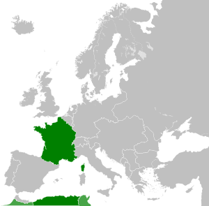


| Ово је ретуширана слика, што значи да је дигитално измењена у односу на своју изворну верзију. Измене: . Изворна верзија се може видети овде: Blank map of Europe 1956-1990.svg.
|
Лиценцирање
Ја, носилац ауторског права над овим делом, објављујем исто под следећом лиценцом:
Ова датотека је доступна под лиценцом Creative Commons Ауторство-Делити под истим условима 3.0 Unported.
- Дозвољено је:
- да делите – да умножавате, расподељујете и преносите дело
- да прерађујете – да прерадите дело
- Под следећим условима:
- ауторство – Морате да дате одговарајуће заслуге, обезбедите везу ка лиценци и назначите да ли су измене направљене. Можете то урадити на било који разуман манир, али не на начин који предлаже да лиценцатор одобрава вас или ваше коришћење.
- делити под истим условима – Ако измените, преобразите или доградите овај материјал, морате поделити своје доприносе под истом или компатибилном лиценцом као оригинал.
Првобитан дневник отпремања
This image is a derivative work of the following images:
- File:Blank_map_of_Europe_1956-1990.svg licensed with Cc-by-sa-3.0
- 2011-10-30T04:43:42Z Alphathon 450x456 (485146 Bytes) == {{int:filedesc}} == {{Information |Description={{en|Blank map of Europe showing national borders as they stood from 1956-1990.}} |Source=*[[:File:Blank_map_of_Europe.svg|]] |Date=2011-10-30 04:42 (UTC) |Author=*[[:File:Bla
Историја датотеке
Кликните на датум/време да бисте видели тадашњу верзију датотеке.
| Датум/време | Минијатура | Димензије | Корисник | Коментар | |
|---|---|---|---|---|---|
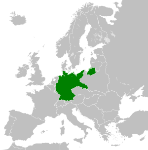
| тренутна | 02:33, 26. новембар 2011. | 450 × 456 (474 kB) | StalwartUK | == {{int:filedesc}} == {{Information |Description={{en|Map of the East Germany (German Democratic Republic) as it was from 1949-1990. Surrounding countries accurate from 1956-1990.}} |Source=*[[:File:Blank_map_of_Europe_1956-1990.svg| |
Употреба датотеке
Следећа страница користи ову датотеку:
Глобална употреба датотеке
Други викији који користе ову датотеку:
- Употреба на af.wikipedia.org
- Употреба на am.wikipedia.org
- Употреба на an.wikipedia.org
- Употреба на ar.wikipedia.org
- Употреба на arz.wikipedia.org
- Употреба на ast.wikipedia.org
- Употреба на azb.wikipedia.org
- Употреба на az.wikipedia.org
- Употреба на ba.wikipedia.org
- Употреба на be.wikipedia.org
- Употреба на bs.wikipedia.org
- Употреба на ca.wikipedia.org
- Употреба на ce.wikipedia.org
- Употреба на cs.wikipedia.org
- Употреба на de.wikipedia.org
- Употреба на de.wiktionary.org
- Употреба на diq.wikipedia.org
- Употреба на el.wikipedia.org
- Употреба на en.wikipedia.org
- Употреба на en.wiktionary.org
- Употреба на eo.wikipedia.org
- Употреба на es.wikipedia.org
- Употреба на es.wiktionary.org
- Употреба на eu.wikipedia.org
- Употреба на ext.wikipedia.org
- Употреба на fa.wikipedia.org
- Употреба на fi.wikipedia.org
- Употреба на fr.wikipedia.org
- Употреба на fr.wiktionary.org
- Употреба на ga.wikipedia.org
- Употреба на gd.wikipedia.org
- Употреба на gl.wikipedia.org
- Употреба на gv.wikipedia.org
- Употреба на he.wikipedia.org
- Употреба на hi.wikipedia.org
- Употреба на hr.wikipedia.org
- Употреба на hr.wiktionary.org
- Употреба на hsb.wikipedia.org
- Употреба на hu.wikipedia.org
- Употреба на hy.wikipedia.org
- Употреба на ia.wikipedia.org
- Употреба на id.wikipedia.org
- Употреба на is.wikipedia.org
Још глобалног коришћења ове датотеке.