Malanje Province
Malanje | |
|---|---|
Province | |
 The Black Rocks of Pungo Andongo | |
| Country | Angola |
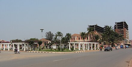
| Capital | Malanje |
| Government | |
| • Governor | Norberto Fernandes dos Santos |
| Area | |
| • Total | 97,602 km2 (37,684 sq mi) |
| Population (2014 census) | |
| • Total | 986,363 |
| Time zone | UTC+01:00 (WAT) |
| ISO 3166 code | AO-MAL |
| Website | www.malanje.gov.ao |
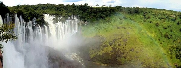
Malanje is a province of Angola. It contains the Kalandula Falls and the Black Rocks of Pungo Andongo.
Geography[change | change source]
The Malanje Province is located in the north of Angola. Its capital, Malanje, is about 383 kilometres (238 miles) east of Luanda, the national capital.[1] It is bordered by Uige Province to the northwest, the Democratic Republic of the Congo to the northeast, Lunda Norte Province and Lunda Sul Province to the east, Bié Province and Cuanza Sul Province to the south, and Cuanza Norte Province to the west.
The northern part of the province is savannah. The southern part is mostly dry savannah. The main rivers are the Cuanza River in the southwest and the Kwango River in the northeast. There is also a mountainous area called the Malanje Plateau.[2]
Near Cangandala National Park, the Cuije River and Cuanza River flow.[3] Protected areas include the Milando Reserve Park (Reserva Especial do Milando) in the north and the Reserva Natural Integral do Luando at the headwaters of the Cuanza River.[1]
Municipalities[change | change source]
Malanje Province has fourteen towns called municipalities (municípios in Portuguese):[4]
- Cacuso
- Calandula
- Cambundi-Catembo
- Cangandala
- Caombo
- Cuaba Nzoji
- Kunda-dia-Base
- Luquembo
- Malanje
- Marimba
- Massango
- Mucari
- Quela
- Quirima
Communes[change | change source]
Malanje Province has 66 small areas called communes (comunas in Portuguese), grouped by their municipalities:
- Cacuso Municipality: – Cacuso, Lombe, Pungo-Andongo, Quizenga (Kizenga), Soqueco (Sokeko)
- Calandula Municipality: – Calandula, Cateco-Cangola (Kateco-Kangola), Cota (Kota), Cuale, Quinje
- Cambundi-Catembo Municipality: – Cambundi-Catembo, Dumba Cambango, Quitapa, Tala Mungongo
- Cangandala Municipality: – Bembo, Cangandala, Caribo (Karibo), Culamagia
- Caombo Municipality: – Bange-Angola, Cambo Suinginge, Caombo, Micanda
- Cuaba Nzoji Municipality: – Cuaba Nzoji, Mufuma
- Kunda-dia-Base Municipality: – Kunda-dia-Base (Cunda-dia-Baze), Lemba, Milando
- Luquembo Municipality: – Capunda, Cunga Palanga, Dombo, Luquembo, Quimbango, Rimba
- Malanje Municipality: – Cambaxe (Kambaxe), Malanje, Ngola-Luije (Nugola-Luije)
- Marimba Municipality: – Cabombo-Lumai (Cabombo), Marimba, Tembo-Aluma
- Massango Municipality: – Massango, Quihuhu, Quinguengue
- Mucari Municipality: – Catala, Caxinga, Mucari-Caculama, Muquixe (Mikixi)
- Quela Municipality: – Bângalas (Missão dos Bangalas), Moma, Quela, Xandele
- Quirima Municipality: – Quirima, Sautar
Economy[change | change source]
Malanje Province's economy focuses mainly on farming. The area around the capital city is busy with farming activities like growing cotton and sugarcane. Cotton used to be very important for the country's economy, but its growth slowed during the Angolan Civil War. Now, agriculture is coming back, and many international investors are helping. For example, Brazil gave $30 million to boost maize and sugarcane farming in Pungo Andongo.[5]
Malanje Province also grows cassava, sweet potatoes, peanuts, rice, soybeans, sunflowers, and different vegetables. Besides farming, the province has valuable resources like diamonds, limestone, manganese (which was exported in large amounts in 1973), uranium, and phosphate.[6]
Tourism is becoming more popular because of the province's natural beauty. People visit attractions like Kalandula Falls, the dark rocks of Pungo Andongo, two nature reserves, and Cangandala National Park. This park is the smallest in Angola. It was started in 1963 to protect the Giant Sable Antelope.[3]
List of governors of Malanje[change | change source]
| Name | Years in office |
|---|---|
| Eusébio Sebastião | 1977–1978 |
| Domingos Afonso Neto | 1978–1980 |
| Col. Ludy Kissassunda | 1980–1986 |
| Lt.Col. João Ernesto dos Santos Liberdade | 1986–1992 |
| João Filipe Martins | 1992 |
| João Manuel Bernardo | 1992–1993 |
| Flávio João Fernandes | 1993–2002 |
| Cristóvão Domingos Francisco da Cunha | 2002–2008 |
| Norberto Fernandes dos Santos Kwata Kwanawa | 2012– |
Up to 1991, the official name was Provincial Commissioner
References[change | change source]
- ↑ 1.0 1.1 Google (22 September 2014). "Malanje Province" (Map). Google Maps. Google. Retrieved 22 September 2014.
- ↑ Goetz, Philip W..; Sutton, Margaret (1983). The New Encyclopædia Britannica. Encyclopædia Britannica. p. 892. ISBN 978-0-85229-400-0.
- ↑ 3.0 3.1 James, W. Martin (5 May 2011). Historical Dictionary of Angola. Scarecrow Press. p. 51. ISBN 978-0-8108-7458-9.
- ↑ "Angola". Geohive. Archived from the original on 30 September 2016. Retrieved 22 September 2014.
- ↑ Cite error: The named reference
SteadRorison2013was used but no text was provided for refs named (see the help page). - ↑ Cite error: The named reference
Publications2003was used but no text was provided for refs named (see the help page). - ↑ "Histórico dos Governadores" (in Portuguese). malanje.gov.ao. Retrieved 6 March 2019.
Other websites[change | change source]
- Official website of province governor
- Information on this province at the Angolan ministry for territorial administration
- Information on this province at Info Angola
- British website (Angola.uk.org) on Malanje province
- Province geographical info at geoview.info
| International | |
|---|---|
| National | |