फायल:Hungary topographic map.jpg
ह्या दाखवणीचो आकार: 800 × 549 चित्रतत्वां. हेर बारिकसाय: 320 × 220 चित्रतत्वां | 640 × 439 चित्रतत्वां | 912 × 626 चित्रतत्वां।
मुळावी फायल (912 × 626 चित्रतत्व, फायलीचो आकार: 75 KB, माइम प्रकार: image/jpeg)
सारांश
| वर्णन |
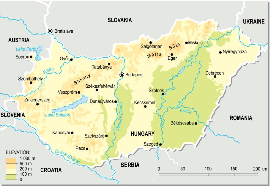
English: Topographic map of Hungary.
Deutsch: Topografische Karte Ungarns. |
| तारीख | |
| स्रोत | स्वताचें काम (from a PD map collection. Mistakes fixed) |
| लेखक | Cserlajos |
| Other versions |
|


|
This map has been uploaded by Electionworld from en.wikipedia.org to enable the |

परवांगी
| This work has been released into the public domain by its author, Cserlajos. This applies worldwide. In some countries this may not be legally possible; if so: |
फायलीचो इतिहास
त्या वेळार फायल कशी आशिल्ली तें पळोवपाक त्या तारीख/वेळाचेर क्लिक करात
| दिस / वेळ | ल्हान-इमाज़ | परिमाण | वापरपी | शेरो | |
|---|---|---|---|---|---|
| आताचें | 05:21, 24 डिसेंबर 2006 | 912 × 626 (75 KB) | Electionworld | {{ew|en|Cserlajos}} == Summary == From a pd map collection. Mistakes fixed by User:cserlajos. == Licensing == {{no rights reserved}} |
फायलिचो वापर
हें पान ही फायल वापरता:
भुमंडळ फाइलीचो वापर
सकयल दिल्ल्यो विकी ही फायल वापरतात
- azb.wikipedia.org चेर जाल्ले वापर
- az.wikipedia.org चेर जाल्ले वापर
- be-tarask.wikipedia.org चेर जाल्ले वापर
- bg.wikipedia.org चेर जाल्ले वापर
- bn.wikipedia.org चेर जाल्ले वापर
- bs.wikipedia.org चेर जाल्ले वापर
- cs.wikipedia.org चेर जाल्ले वापर
- da.wikipedia.org चेर जाल्ले वापर
- de.wikipedia.org चेर जाल्ले वापर
- de.wikibooks.org चेर जाल्ले वापर
- en.wikipedia.org चेर जाल्ले वापर
- eu.wikipedia.org चेर जाल्ले वापर
- fa.wikipedia.org चेर जाल्ले वापर
- fi.wikipedia.org चेर जाल्ले वापर
- fr.wikipedia.org चेर जाल्ले वापर
- gl.wikipedia.org चेर जाल्ले वापर
- he.wikipedia.org चेर जाल्ले वापर
- hr.wikipedia.org चेर जाल्ले वापर
- hr.wiktionary.org चेर जाल्ले वापर
- hu.wikipedia.org चेर जाल्ले वापर
- hu.wikibooks.org चेर जाल्ले वापर
- hy.wikipedia.org चेर जाल्ले वापर
- io.wikipedia.org चेर जाल्ले वापर
ह्या फायलीचें वैश्वीक वापरांची चड म्हायती पळयात.