| |
|
|


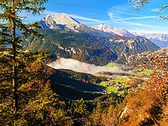
A mountain is an elevated portion of the Earth's crust, generally with steep sides that show significant exposed bedrock. Although definitions vary, a mountain may differ from a plateau in having a limited summit area, and is usually higher than a hill, typically rising at least 300 metres (980 ft) above the surrounding land. A few mountains are isolated summits, but most occur in mountain ranges.
Mountains are formed through tectonic forces, erosion, or volcanism, which act on time scales of up to tens of millions of years. Once mountain building ceases, mountains are slowly leveled through the action of weathering, through slumping and other forms of mass wasting, as well as through erosion by rivers and glaciers.
High elevations on mountains produce colder climates than at sea level at similar latitude. These colder climates strongly affect the ecosystems of mountains: different elevations have different plants and animals. Because of the less hospitable terrain and climate, mountains tend to be used less for agriculture and more for resource extraction, such as mining and logging, along with recreation, such as mountain climbing and skiing.
The highest mountain on Earth is Mount Everest in the Himalayas of Asia, whose summit is 8,850 m (29,035 ft) above mean sea level. The highest known mountain on any planet in the Solar System is Olympus Mons on Mars at 21,171 m (69,459 ft). (Full article...)
Side valleys and tributary valleys are valleys whose brooks or rivers flow into greater ones.
Upstream, the valleys can be classified in an increasing order which is equivalent to the usual orographic order: the tributaries are ordered from those nearest to the source of the river to those nearest to the mouth of the river. A confluence is where two or more tributaries or rivers flow together. (Full article...)

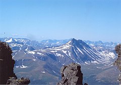
Sierra Baguales or Sierra de los Baguales is a mountain range in the southernmost Andes. Sierra Baguales is a 60 kilometres (37 mi) long east–west chain, secondary to the main chain of the Andes that lie further west. It lies along the border between Chile and Argentina near the localities of Puerto Natales and Río Turbio. (Full article...)

Extrusive rock refers to the mode of igneous volcanic rock formation in which hot magma from inside the Earth flows out (extrudes) onto the surface as lava or explodes violently into the atmosphere to fall back as pyroclastics or tuff. In contrast, intrusive rock refers to rocks formed by magma which cools below the surface.
The main effect of extrusion is that the magma can cool much more quickly in the open air or under seawater, and there is little time for the growth of crystals. Sometimes, a residual portion of the matrix fails to crystallize at all, instead becoming a natural glass like obsidian. (Full article...)
Climbing is a major US-based rock climbing magazine first published in 1970. In 2007, it was bought by Skram Media, the publisher of Urban Climber Magazine. The headquarters of the magazine is in Boulder, Colorado. It is published nine times a year. Climbing was purchased by Outside in 2021. (Full article...)
-
Winter campers bivouaced in the snow (from Mountaineering)
-
-
-
British mountaineer William Cecil Slingsby became known as the father of Norwegian mountaineering and contributed greatly to its popularization with his classic book Norway, the Northern Playground (from Mountaineering)
-
Choppering out the injured – with Mt. Forbes in the background (from Mountain rescue)
-
Chimborazo, Ecuador, whose summit is the point farthest away from the Earth's center (from Mountain)
-
The Andes, the longest mountain range on the surface of the Earth, have a dramatic impact on the climate of South America (from Mountain range)
-
-
-
Car of Horská služba (Czech Republic) (from Mountain rescue)
-
The northern Urals at high latitude and elevation have an alpine climate and barren ground. (from Mountain)
-
-
Stretcher box in Cumbria, England, prepositioned equipment saves mountain rescue teams having to trudge up mountains with it. (from Mountain rescue)
-
Iranian oak scrub in the Zagros Mountains (from Montane ecosystems)
-
Everest is highest from sea level (green), Mauna Kea is highest from its base (orange), Cayambe is farthest from Earth's axis (pink) and Chimborazo is farthest from Earth's centre (blue) (from Mountain)
-
-
Climber approaching the summit of Manaslu at 8,163 metres (from Mountaineering)
-
-
-
Alpine flora near Cascade Pass (from Montane ecosystems)
-
Mountain rescue team members and other services attend to a casualty in Freiburg Germany. (from Mountain rescue)
-
Tropical montane forest at around 2,000 m in Malaysia (from Montane ecosystems)
-
Mount Everest, Earth's highest mountain (from Mountain)
-
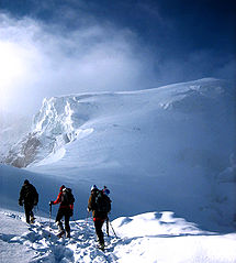
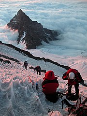
Mountaineers proceed across snow fields on South Tyrol; other climbers are visible further up the slopes. (from Mountaineering)
-
-
A stand of mountain birch at around 750 m in Trollheimen, typical of Scandinavian subalpine forests (from Montane ecosystems)
-
The Ocean Ridge, the world's longest mountain range (chain) (from Mountain range)
-
Antique climbing tools (from Mountaineering)
-
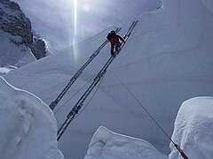
Fixed lines and ladders are distinguishing characteristics of expedition style mountaineering (from Mountaineering)
-
-
A mountain rescue team in Iran moving a casualty. (from Mountain rescue)
-
Edelweiss, a plant associated with mountain sports (from Mountaineering)
-
Fuji volcano (from Mountain)
-
The Namcha Barwa Himal, east part of the Himalayas as seen from space by Apollo 9 (from Mountain range)
-
Mountaineers, c. 1900 (from Mountaineering)
-
-
This 1848 "Sketch showing the actual elevation of the Snow Line in different Latitudes" by Alexander Keith Johnston shows the snow lines of mountains in America, Europe and Asia (from Snow line)
-
-
Mountaineers climbing in South Tyrol (from Mountain)
-


The stem christie or wedge christie, is a type of skiing turn that originated in the mid-1800s in Norway and lasted until the late 1960s. It comprises three steps: 1) forming a wedge by rotating the tail of one ski outwards at an angle to the direction of movement, initiating a change in direction opposite to the stemmed ski, 2) bringing the other ski parallel to the wedged ski, and 3) completing the turn with both skis parallel as they carve an arc, sliding sideways together. (Full article...)
Do you have a question about Mountains that you can't find the answer to? Consider asking it at the Wikipedia reference desk.
For editor resources and to collaborate with other editors on improving Wikipedia's Mountains-related articles, see WikiProject Mountains.

- Africa: Atlas • Kilimanjaro • Mount Kenya massif • Ruwenzori Mountains
- America: Andes • Appalachians • Cascades • Cordilleras • Rockies • Sierra Nevada
- Antarctica: Sentinel Range
- Asia: Altai • Himalaya • Hindu Kush • Caucasus • Karakoram • Pamir
- Australia and Oceania: Maoke Mountains • New Zealand Alps • Snowy Mountains
- Europe: Alps • Ardennes • Balkans • Highlands • Jura • Carpathians • Pyrenees • Scandinavian Mountains • Urals • Vosges

- Alps: Piz Badile • Mont Blanc • Petit Dru • Dufourspitze • Eiger • Großglockner • Grandes Jorasses • Jungfrau • Königspitze • Matterhorn • Mönch • Ortler • Watzmann • Drei Zinnen • Zugspitze
- Andes: Aconcagua • Alpamayo • Chimborazo • Cotopaxi • Fitz Roy • Nevado Huascarán • Illimani • Sajama • Ojos del Salado • Siula Grande • Cerro Torre • Yerupaja

- Himalayas: Eight-thousanders – Mount Everest • K2 • Kangchenjunga • Lhotse • Makalu • Cho Oyu • Dhaulagiri • Manaslu • Nanga Parbat • Annapurna I • Hidden Peak • Broad Peak • Gasherbrum II • Shishapangma – Other – Ama Dablam • Chogolisa • Masherbrum • Shivling
- Rocky Mountains: Mount Chephren • Mount Elbert • Mount Logan • Denali • Mount Robson
- Volcanos: Etna • Eldfell • Hohentwiel • Mauna Kea • Pinatubo • Puʻu ʻŌʻō • Mount St. Helens • Stromboli • Mount Unzen

- Plants: Alpine Rock-Jasmine • Hairy Alpenrose • Edelweiss • Great Yellow Gentian • Glacier Crowfoot • Wulfenia • Dwarf Willow • Queen of the Andes • Arolla Pine
- Animals: Red-billed Chough • Alpine marmot • Alpine Salamander • Rock Ptarmigan • Alpine Ibex • Andean Condor • Bearded Vulture • Alpine Chough • Chamois • Mountain Burnet • European Viper • Himalayan Tahr • Wallcreeper • White-winged Snowfinch • Golden Eagle • Northern Bald Ibis • Yak

- Equipment: Ascenders • Belay devices • Carabiners • Maillons • Harnesses • Hexes • Nuts • Quickdraws • Ropes • Shoes • SLCDs • Slings • Tricams
- Techniques: Abseiling • Redpointing • Anchor • Mantle • Top roping • Climbing grade • Climbing route
- Types of climbing: Big wall climbing • Bouldering • Competition climbing • Free climbing • Ice climbing • Mountain climbing • Rock climbing • Schrofen • Sport climbing
- Klettersteigs: Mannlgrat
- Climbers: Kurt Albert • Pierre Allain •John Bachar • Henry Barber • Catherine Destivelle • Patrick Edlinger • John Gill • Stefan Glowacz • Wolfgang Güllich • Lynn Hill • Alex Honnold • Alexander Huber • John Long • Jeff Lowe • Magnus Midtbø • Adam Ondra • Dean Potter • Alain Robert • Chris Sharma • Todd Skinner • Ueli Steck • Other climbers

- Mountaineering: Alpine Clubs • Boots • Crampons • Ice axes • Mountain huts • Mountain rescue • Ropes • Rucksacks
- Pioneers: Christian Almer • Melchior Anderegg • Hermann von Barth • Walter Bonatti • Meta Brevoort • William Martin Conway • Angelo Dibona • Hans Dülfer • Paul Grohmann • Adolphus Warburton Moore • Paul Preuss • Ludwig Purtscheller • Schlagintweit brothers • Leslie Stephen • Gottlieb Samuel Studer • Tenzig Norgay • Herbert Tichy • Lucy Walker • Edward Whymper • Georg Winkler • Matthias Zurbriggen
- High-altitude mountaineers: Chris Bonington • Hermann Buhl • Kurt Diemberger • Ralf Dujmovits • Günther Dyhrenfurth • Maurice Herzog • Sir Edmund Hillary • Sandy Irvine • Gerlinde Kaltenbrunner • George Mallory • Nives Meroi • Reinhold Messner • Simone Moro • Oh Eun-sun • Edurne Pasaban • Wanda Rutkiewicz • Lionel Terray • Um Hong-Gil • Stephen Venables • Ed Viesturs • Other mountaineers
- Publicists: Karl Blodig • W. A. B. Coolidge • David Breashears • Jon Krakauer • Gaston Rébuffat
- Alps: Eiger climbing history • Exploration of the High Alps • Golden age of alpinism • Silver age of alpinism • Timeline of climbing the Matterhorn
- Himalayas: 1922 British Mount Everest expedition • 1924 British Mount Everest expedition • 1953 British Mount Everest expedition • 1986 K2 disaster • 1996 Mount Everest disaster • 2008 K2 disaster • Timeline of climbing Mount Everest
- Museums: Alpine Club Museum • Messner Mountain Museum
- Featured content
- Good content
Amak Volcano
The following Wikimedia Foundation sister projects provide more on this subject:
-
Commons
Free media repository -
Wikibooks
Free textbooks and manuals -
Wikidata
Free knowledge base -
Wikinews
Free-content news -
Wikiquote
Collection of quotations -
Wikisource
Free-content library -
Wikiversity
Free learning tools -
Wikivoyage
Free travel guide -
Wiktionary
Dictionary and thesaurus