This is a list of islands in Papua New Guinea, as to most of its 600 main islands, by province listed NW to SE.[1]

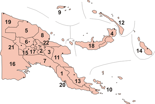
(No. 5 on the map)
- Schouten Islands, a loose group of islands off the coast of the East Sepik Province
(No. 19 on the map)
(No. 9 on the map)
- Admiralty Islands, group of 18 islands including:
- Western Islands, with:
(No. 12 on the map)
(No. 18 on the map)
- New Britain or also Niu Briten, main island
- Vitu Islands
(No. 4 on the map)
- New Britain or also Niu Briten, main island
- Watom Island
- Matupi Island
- Duke of York Islands
(No 8 on the map)
(No. 11 on the map)
(No. 14 on map)
(No. 16 on map)
- Daru Island
- Bristow Island
- Kawai Islands
- Kawa Island
- Karobailo Kawa Island
- Mata Kawa Island
- Parama Island
- Kiwai Island
- Purutu Island
- Wabuda Island
(No. 7 on map)
(No. 20 on map)
- Daugo Island
- Manubada Island
- Haidana Island
• Loloata Islands
(No. 10 on the map)
- South Coast Islands
- Bona Bona
- Brumer Islands
- Baliabedabeda Bonarua
- Halioya
- Deirina
- Trobriand Islands
- D'Entrecasteaux Islands
- Fergusson Island
- Goodenough Island
- Normanby Island (Papua New Guinea)
- Sanaroa Island
- Dobu Island
- Sori (or Wild) Island
- Woodlark Islands
- Louisiade Archipelago
- Samarai Islands
- Basilaki Island
- Beika Island
- Bonarua Hili Hili Island
- Buiari Island
- Castori Islets
- Dagadaga Bonarua Island
- Deka Deka Island
- Didigilo Island
- Dinana Island
- Doini Island
- Ebuma Island
- Gado-Gadoa Island
- Galahi Island
- Gesila Island
- Gonabarabara Island
- Grant Island
- Igwali Island
- Ito Island
- Kitai Bai Island
- Kato Katoa Island
- Kitai Bona Bona Island
- Kitai Katu Island
- Kitai Lilivea Island
- Kui Island
- Kwai Ama Island
- Kwato Island
- Lesimano Island
- Logea Island
- Nasariri Island
- Populai Island
- Samarai
- Sariba Island
- Sideia Island
- Sripkunui Island
- Tuyam Island
- Wasima Island
- Bentley Islands
- Bonvouloir Islands
- Calvados Chain
- Conflict Group
- Auriroa Island
- Gabugabutau Island
- Ginara Island
- Irai Island
- Itamarina Island
- Lunn Island
- Moniara Island
- Panaboal Island
- Panarakuum Island
- Panasesa Island
- Quesal Island
- Tupit Island
- Deboyne Islands
- Losai Island; Nibub Island; Nivani Island
- Pana Uya Wana; Panaeati; Panapompom
- Passage Island
- Rara Island
- Duchateau Islands
- Dumoulin Islands
- Duperre Islands
- East Deboyne Islands
- Engineer Islands
- Bright Island; Butchart Island; Button Island
- Deedes Island; Flat Island; Good Island; Haszard Island
- Hummock Island
- Messum Island; Pender Island; Powell Island
- Skelton Island; Slade Island; Watts Island
- Laseinie Islands
- Dawson Island, Kagawan Island; Keaawan Island
- Hardman Islands
- Misima Island
- Daloloia Group
- Pana Tinani Islands
- Nimoa Island
- Pana Tinani
- Wanim Island
- Yeina Island
- Daddahai Island; Hevaisi Island; Osasai Island; Sibumbum Island
- Renard Islands
- Baiwa; Kimuta; Manuga Reef; Oreia
- Rossel Islands
- Torlesse Islands
- Pananiu Island
- Tinolan
- Vanatinai Islands
- Boboa Island
- Iyen Island
- Tagula Island also known as Vanatinai Island and Sudest Island
- Venama
- Wari Islands
- Imbert Island
- Kosman Reef
- Lebrun Islands
- Long Island
- Quessant Island
- Sable Island
- Siga Island
- Stuers Islands
- Wari Island
- Samarai Islands
References
edit- ^ "Papua New Guinea". The Commonwealth. Retrieved 17 May 2019.