File:Carreg Leidr - the petrified remains of the Llandyfrydog Bible Thief - geograph.org.uk - 1231141.jpg
Size of this preview: 450 × 600 pixels. Other resolutions: 180 × 240 pixels | 480 × 640 pixels.
Original file (480 × 640 pixels, file size: 100 KB, MIME type: image/jpeg)
| This is a file from the Wikimedia Commons. Information from its description page there is shown below. Commons is a freely licensed media file repository. You can help. |
| This image appeared on Wikipedia's Main Page in the Did you know? column on 30 January 2011 (see archives). |
Summary
| Description |
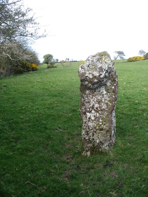
English: Carreg Leidr - the petrified remains of the Llandyfrydog Bible Thief, near to Llandyfrydog, Isle of Anglesey/Sir Ynys Mon, Great Britain.
According to an old local legend. this standing stone which has a prominent bulge on one side, is the petrified body of thief who was making his getaway after stealing the bible from Llandyfrydog Church, the stolen bible being carried in a sack on his back. The road from this spot to Llandyfrydog Church is known as Lon Leidr (Thief's Lane) |
| Date | |
| Source | From geograph.org.uk; transferred by User:Bencherlite using geograph_org2commons. |
| Author | Eric Jones |
| Permission (Reusing this file) |
Creative Commons Attribution Share-alike license 2.0 |
| Attribution (required by the license) | Eric Jones / Carreg Leidr - the petrified remains of the Llandyfrydog Bible Thief / |
| Camera location | | View this and other nearby images on: OpenStreetMap |
|---|
| Object location | | View this and other nearby images on: OpenStreetMap |
|---|
Licensing

|
This image was taken from the Geograph project collection. See this photograph's page on the Geograph website for the photographer's contact details. The copyright on this image is owned by Eric Jones and is licensed for reuse under the Creative Commons Attribution-ShareAlike 2.0 license.
|
This file is licensed under the Creative Commons Attribution-Share Alike 2.0 Generic license.
Attribution: Eric Jones
- You are free:
- to share – to copy, distribute and transmit the work
- to remix – to adapt the work
- Under the following conditions:
- attribution – You must give appropriate credit, provide a link to the license, and indicate if changes were made. You may do so in any reasonable manner, but not in any way that suggests the licensor endorses you or your use.
- share alike – If you remix, transform, or build upon the material, you must distribute your contributions under the same or compatible license as the original.
File history
Click on a date/time to view the file as it appeared at that time.
| Date/Time | Thumbnail | Dimensions | User | Comment | |
|---|---|---|---|---|---|
| current | 22:01, 19 January 2011 | 480 × 640 (100 KB) | File Upload Bot (Magnus Manske) |
File usage
The following pages on the English Wikipedia use this file (pages on other projects are not listed):
Global file usage
The following other wikis use this file:
- Usage on arz.wikipedia.org
- Usage on ceb.wikipedia.org
- Usage on cy.wikipedia.org
- Usage on es.wikipedia.org
- Usage on eu.wikipedia.org
- Usage on fa.wikipedia.org
- Usage on fr.wikipedia.org
- Usage on ga.wikipedia.org
- Usage on it.wikipedia.org
- Usage on www.wikidata.org
- Usage on zh-min-nan.wikipedia.org