Martinez, California
Martinez, California | |
|---|---|
 Location in Contra Costa County and the state of California | |
| Country | United States |
| State | California |
| County | Contra Costa |
| Government | |
| • Senate | Tom Torlakson (D) |
| • Assembly | Mark DeSaulnier (D) |
| • U. S. Congress | George Miller (D) |
| Area | |
| • Total | 13.5 sq mi (34.8 km2) |
| • Land | 12.3 sq mi (31.7 km2) |
| • Water | 1.2 sq mi (3.1 km2) |
| Elevation | 23 ft (7 m) |
| Population (2000) | |
| • Total | 35,866 |
| • Density | 2,656.7/sq mi (1,030.6/km2) |
| Time zone | UTC-8 (PST) |
| • Summer (DST) | UTC-7 (PDT) |
| ZIP code | 94553 |
| Area code | 925 |
| FIPS code | 06-46114 |
| GNIS feature ID | 0277553 |
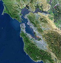
Martinez is the county seat of Contra Costa County, California, United States. The population was 35,866 at the 2000 census. The downtown is notable for its large number of preserved old buildings. Martinez is located on the south side of the Carquinez Strait in the San Francisco Bay Area, directly facing the city of Benicia. Martínez means "son of Martín" in Spanish, and in this sense the name is the English equivalent of the surname "Martinson".
History
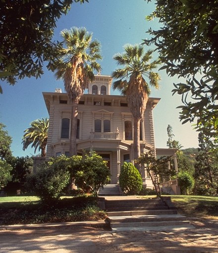
In 1824 the Alhambra Valley was included in a land grant to Don Ygnacio Martínez by the Mexican government for services rendered to the Mexican and Spanish armies.[1] By 1849, Martínez served as a way station for the California Gold Rush. It became the county seat in 1850, but could not incorporate at the time because it lacked the 200 registered voters required, and only became a city in 1876.[2] In 1847, Dr. Robert Semple contracted to provide ferry service from Martinez to Benicia, CA (across the Carquinez straight, Benicia was a growing community and state capitol for a year in 1852).[3] Martinez was the home of John Muir from 1880 until his death in 1914. He was buried about a mile south of the building that is now the John Muir National Historic Site. Also nearby is the property is the Don Vicente Martinez Adobe, built in 1849 by the son of Rancho owner, Don Ygnacio Martinez, of the Rancho el Pinole. [4]
In 1860, Martinez played a role in the Pony Express, where riders would take the ferry from Benicia (particularly if they missed the steamer in Sacramento).[5] In 1915, Shell Oil Company built an oil refinery near Martinez, which sparked a building boom in the area. Martinez's oil refineries can still be seen today from Interstate 680, and it continues to be a significant port and petroleum processing center.
Martinez is also purportedly the birthplace of the martini.[6]
Geography
According to the United States Census Bureau, the city has a total area of 13.4 square miles (34.8 km²), of which, 12.2 square miles (31.7 km²) of it is land and 1.2 square miles (3.1 km²) of it (8.92%) is water.
Although the common perception of Martinez is that of a refinery town, given the view from Highway 680 across the Shell Refinery and the strong smell of petroleum that greets visitors coming from the Martinez-Benicia Bridge, the city is in fact largely surrounded by water and regional open space preserves. The Martinez-Benicia Bridge carries Highway 680 across the eastern end of the Carquinez Strait to Solano County.
The city can be defined as a more densely built downtown valley threaded by Alhambra creek and north of Highway 4. Suburban areas stretch south of Highway 4 to join the neighboring city of Pleasant Hill. Unincorporated areas include the rural Alhambra Valley and the Franklin Canyon area.
The Martinez Regional Shoreline bounds the city to the north along the Carquinez Strait. Carquinez Strait Regional Shoreline includes the Franklin Hills west of downtown, stretching west to the unincorporated community of Port Costa and the town of Crockett. Briones Regional Preserve borders the Alhambra Valley to the south. Waterbird Regional Park and the McNabney Marsh border the city and Highway 680 to the east.
Martinez's location at the east end of the Carquinez Strait as it widens to Suisun Bay includes dramatic water views stretching to the Sierra rannge. From surrounding ridge tops views stretch to nearby Mt. Diablo, Mt. St. Helena, Mt. Tamalpais, etc.
Martinez is one of the only two places in the Bay Area--the other is the Golden Gate Bridge--where the Bay Area Ridge Trail and the San Francisco Bay Trail converge. The Bay Trail is a planned recreational corridor that, when complete, will encircle San Francisco and San Pablo Bays with a continuous 400-mile network of bicycling and hiking trails. It will connect the shoreline of all nine Bay Area counties, link 47 cities, and cross the major toll bridges in the region, including the Martinez-Benicia Bridge. To date, approximately 240 miles of the alignment—over half the Bay Trail’s ultimate length—have been completed. The Bay Area Ridge Trail ultimately will be a 500+ mile trail encircling the San Francisco Bay along the ridge tops, open to hikers, equestrians, mountain bicyclists, and outdoor enthusiasts of all types. So far, over 300 miles of trail have been dedicated for use. East Bay Regional Park District's Iron Horse Regional Trail will join the Bay Trail along the waterfront, and the Contra Costa Canal Trail threads through the city from Pleasant Hill to the south.
Demographics
As of the censusTemplate:GR of 2000, there were 35,866 people, 14,300 households, and 9,209 families residing in the city. The population density was 2,927.6 people per square mile (1,130.4/km²). There were 14,597 housing units at an average density of 1,191.5/sq mi (460.1/km²). The racial makeup of the city was 81.03% White, 3.35% Black or African American, 0.74% Native American, 6.63% Asian, 0.23% Pacific Islander, 3.29% from other races, and 4.72% from two or more races. 10.20% of the population were Hispanic or Latino of any race.
There were 14,300 households out of which 30.0% had children under the age of 18 living with them, 49.4% were married couples living together, 11.0% had a female householder with no husband present, and 35.6% were non-families. 27.4% of all households were made up of individuals and 6.9% had someone living alone who was 65 years of age or older. The average household size was 2.41 and the average family size was 2.96.
In the city the population was spread out with 22.7% under the age of 18, 7.3% from 18 to 24, 32.6% from 25 to 44, 27.3% from 45 to 64, and 10.1% who were 65 years of age or older. The median age was 39 years. For every 100 females there were 98.5 males. For every 100 females age 18 and over, there were 96.0 males.
The median income for a household in the city was $63,010, and the median income for a family was $77,411. Males had a median income of $52,135 versus $40,714 for females. The per capita income for the city was $29,701. About 3.2% of families and 5.2% of the population were below the poverty line, including 3.9% of those under age 18 and 4.8% of those age 65 or over.
64, and 10.1% who were 65 years of age or older. The median age was 39 years. For every 100 females there were 98.5 males. For every 100 females age 18 and over, there were 96.0 males.
The languages spoken were 88% English, 6% Spanish, 2% Tagalog, 1% German, 1% Chinese, 0.5% Italian, 0.5% Persian, 0.3% Korean, 0.3% Portuguese, 0.25% Russian, 0.25% Arabic, 0.2% Dutch, 0.2% Polish, 0.2% French, 0.2% Punjabi, 0.2%Vietnamese, 0.14% Japanese, 0.14% Tamil, 0.07% Cantonese. Of the 4,176 people who did not use English as their primary language 3,663 (87.72%) spoke it well or very well while 513 (12.28%) spoke it "not well" or "not at all"[7]
Transportation

Amtrak, the national passenger rail system, provides service to Martinez.
The California Zephyr operates daily in each direction through Martinez between Emeryville, across the bay from San Francisco, and Chicago via Sacramento, Reno, Salt Lake City, Denver, and Omaha.
The Coast Starlight operates daily in each direction through Martinez between Seattle and Los Angeles.
Amtrak operates its Capitol Corridor trains through Martinez station, providing service several times daily between San Jose to the west and Reno, Nevada via Sacramento to the east. Service to Reno, NV is from via rail to as far as Aurburn, CA and Amtrak California coach buses to Reno. Connections can be made to the BART system at the next stop Richmond BART Station. In addition to feeder service provided by WestCat to the El Cerrito del Norte BART Station and by the County Connection to the Concord, Pleasant Hill, and Walnut Creek BART stations. The latter bus operator is also the primary local bus operator which provices service throughout the area. Benicia Breeze provides service to Solano County across the Benicia-Martinez Bridge to Benicia, and the Vallejo Ferry Terminal in Vallejo. There is also service to the East County area of Contra Costa County provided by Tri-Delta Transit. Paratransit services are provided by the County Connection. Although there is no BART station in Martinez, the North Concord Station is officially know as North Concord/Martinez BART station but lies miles west of the city limits. The city was overlooked when the system was extended from Concord to Bay Point. However BART´s long term plans include a new line extension running from Fremont and through the I-680 corridor and ending in Martinez. The new line will run along this course and continue along the planned extention to San José. Another planned configuration will be a BART or BART substitue rail service running between Martinez and East County.
Amtrak also operates its San Joaquin trains through Martinez, providing service several times daily between Oakland to the west and Bakersfield at the south end of the San Joaquin Valley. Bus connections can be made between Bakersfield and Los Angeles.
Schools
Covering most of Martinez, the Martinez Unified School District encompasses four elementary schools, one middle school, one high school, and two alternative/independent study schools. Students in K-5 attend John Swett, John Muir, Las Juntas, or Morello Park Elementary School. Martinez Junior High School serves students in grades 6 through 8. St. Catherine of Siena is a private Catholic school that serves grades K-8. Alhambra High School serves as the districts' comprehensive high school. As of 2006, the districts' K-12 enrollment was 4,194. Part of Martinez is served by the Mount Diablo Unified School District, whose Hidden Valley Elementary School is located in Martinez.
Beaver controversy
In early 2007, a group of beavers settled in a section of Alhambra Creek that flows through the city. The beavers and their dam became a local attraction. Because of the risk of flooding posed by the dam, local officials proposed to remove the beavers. A lively debate arose on how to remove the beavers, particularly over an option which would have them killed. A compromise was later reached, resulting in their humane removal and relocation.
See also
Notable Martinez residents
- Yau-Man Chan, Survivor Fiji
- John Muir, Naturalist
- Joe Dimaggio, baseball player
- Tug McGraw, baseball player
- Jello Biafra, Song writer
- Sara Del Rey, Professional Wrestler
- New York Yankee baseball player Joe DiMaggio was born in the town in 1914.
- NFL head coach Norv Turner and his brother Ron who is on the Chicago Bears staff grew up in Martinez.
- Jeff Van Gundy, Former Houston Rockets head coach and current ESPN announcer, and his brother Stan were raised in Martinez.
References
- ^ Martinez Historical Society
- ^ Martinez, CA, City History
- ^ Martinez Historical Society
- ^ Martinez, CA, City History
- ^ Martinez History and the Pony Express
- ^ Swank Martini: The History of a Martini
- ^ MLA Data Center, Martínez, California entry, U.S. Census Dept. (Census 2000), retrieved 2008-01-17
External links
Template:Geolinks-US-cityscale

| Bodies of water |
|  | |||||||||||
|---|---|---|---|---|---|---|---|---|---|---|---|---|---|
| Counties | |||||||||||||
| Cities and towns |
| ||||||||||||
| CDPs over 10k | |||||||||||||
| Sub-regions | |||||||||||||
| Other | |||||||||||||