Original file (SVG file, nominally 1,642 × 1,036 pixels, file size: 1.25 MB)
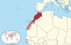
This SVG map is part of a locator map series applying the widespread location map scheme. Please see root category to browse for more.
{{published|author= |date= |url= |title= |org= }}
বাংলা ∙ Deutsch ∙ Deutsch (Sie-Form) ∙ Ελληνικά ∙ English ∙ español ∙ français ∙ Ἀρχαία ἑλληνικὴ ∙ Bahasa Indonesia ∙ 日本語 ∙ македонски ∙ Nederlands ∙ português ∙ русский ∙ Türkçe ∙ 简体中文 ∙ 繁體中文 ∙ +/−
Click on a date/time to view the file as it appeared at that time.
You cannot overwrite this file.
The following 5 pages use this file:
The following other wikis use this file: