Original file (3,032 × 1,998 pixels, file size: 3.78 MB, MIME type: image/jpeg)
http://www.nasa.gov/multimedia/imagegallery/image_feature_152.html
العربية ∙ беларуская (тарашкевіца) ∙ български ∙ català ∙ čeština ∙ dansk ∙ Deutsch ∙ English ∙ español ∙ فارسی ∙ français ∙ galego ∙ magyar ∙ հայերեն ∙ Bahasa Indonesia ∙ italiano ∙ 日本語 ∙ македонски ∙ മലയാളം ∙ Nederlands ∙ polski ∙ português ∙ русский ∙ sicilianu ∙ slovenščina ∙ Türkçe ∙ українська ∙ 简体中文 ∙ 繁體中文 ∙ +/−
If you have an image of better quality that can be published under a suitable copyright license, be sure to upload it, tag it, and nominate it.
العربيَّة | Deutsch | English | español | français | italiano | kurdî | македонски | മലയാളം | português | sicilianu | +/−
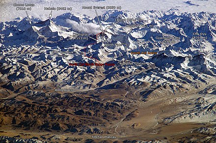
Makalu
Mount Everest
Lhotse
Cho Oyu
Khumbu Icefall
Chomo Lonzo
Changtse
Nuptse
Rongbuk Glacier
Click on a date/time to view the file as it appeared at that time.
You cannot overwrite this file.
The following 52 pages use this file:
The following other wikis use this file:
View more global usage of this file.
This file contains additional information such as Exif metadata which may have been added by the digital camera, scanner, or software program used to create or digitize it. If the file has been modified from its original state, some details such as the timestamp may not fully reflect those of the original file. The timestamp is only as accurate as the clock in the camera, and it may be completely wrong.