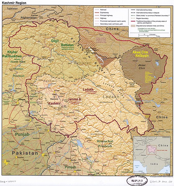
أكساي تشين
| أكساي تشين | |
|---|---|
| منطقة تديرها الصين | |
 علامة معسكر للقوات الصينية في Tianshuihai، أكساي تشين
| |
 | |
 خريطة تفاعلية لأكساي تشين
| |
 |
|
| الإحداثيات | 35°00′N 79°00′E / 35.0°N 79.0°E |
| تقسيم إداري | |
| الدولة | |
| منطقة أو قائمة مقاطعات الهند | |
| خصائص جغرافية | |
| المساحة | 38٬000 كم2 (15٬000 ميل2) |
| تعديل مصدري - تعديل | |
أكساي تشينهي منطقة متنازع عليهما بين الهند والصين منذ عام 1959.[1] تقع المنطقة غرب جبال الهيمالايا ضمن منطقة كشمير، تدير الصين المنطقة ويتبع جزء منها لمقاطعة هوتان، ولاية هوتان، سنجان[2] والجزء الأخر لمقاطعة روتوج، ولاية نغاري، التبت.
التأثيل[عدل]
أول من ذكر اسم أكساي تشين هو محمد أمين المرشد الياركندي للأخوة شلاغنتويت الذي تعاقدت معه شركة الهند الشرقية البريطانية لاستكشاف آسيا الوسطى. ذكر محمد أمين أن معنى الاسم "صحراء الرمال البيضاء الكبرى".[3] يقول اللغوي جورج فان دريم أن الاسم الذي قصده أمين كان أكساي تشول (بالأويغورية: ئاقساي چۆل) والتي يمكن أن تعني "صحراء الوادي الأبيض". يبدو أن كلمة chöl التي تعني الصحراء حرفت في الترجمة الصوتية الإنجليزية إلى "تشين".[3]
ذكرت بعض المصادر أن أكساي تعني في اللغة الأويغورية الصحراء الحجرية البيضاء ممن يذكر هذا الرأي العديد من المصادر الاستعمارية البريطانية[4][5] والغربية الحديثة[6][7][8][9] والصينية[2][10] والهندية.[11][12] بينما تذكر بعض المصادر الحديثة أنها تعني "النهر الأبيض".[13][14] يذكر مصدر وحيد أن أكساي تعني "الشرقية" في لهجة الياركاندي الأويغورية.[15]
سُفرت كلمة "تشين" بالصين" في بعض المصادر الصينية[2][10][16] والغربية[4][8] والهندية.[15] يذكر مصدر واحد على الأقل أنها تعني "المرور".[13] في حين لم تذكر مصادر أخرى كلمة "تشين" في تفسيرها لاسم المنطقة.[5][6][7][9][11][12]
لم يحدد محمد أمين حدود واضحة لأكساي تشين بل كانت هي المنطقة الممتدة غرب التبت جنوب جبال كونلون.[17][18] أول من ذكر اسم أكساي تشين هو محمد أمين المرشد الياركندي للأخوة شلاغنتويت الذي تعاقدت معه شركة الهند الشرقية البريطانية لاستكشاف آسيا الوسطى. ذكر محمد أمين أن معنى الاسم "صحراء الرمال البيضاء الكبرى".[3] يقول اللغوي جورج فان دريم أن الاسم الذي قصده أمين كان أكساي تشول (بالأويغورية: ئاقساي چۆل) والتي يمكن أن تعني "صحراء الوادي الأبيض". يبدو أن كلمة chöl التي تعني الصحراء حرفت في الترجمة الصوتية الإنجليزية إلى "تشين".[3]
ذكرت بعض المصادر أن أكساي تعني في اللغة الأويغورية الصحراء الحجرية البيضاء ممن يذكر هذا الرأي العديد من المصادر الاستعمارية البريطانية[4][5] والغربية الحديثة[6][7][8][9] والصينية[2][10] والهندية.[11][12] بينما تذكر بعض المصادر الحديثة أنها تعني "النهر الأبيض".[13][14] يذكر مصدر وحيد أن أكساي تعني "الشرقية" في لهجة الياركاندي الأويغورية.[15]
سُفرت كلمة "تشين" بالصين" في بعض المصادر الصينية[2][10][16] والغربية[4][8] والهندية.[15] يذكر مصدر واحد على الأقل أنها تعني "المرور".[13] في حين لم تذكر مصادر أخرى كلمة "تشين" في تفسيرها لاسم المنطقة.[5][6][7][9][11][12]
لم يحدد محمد أمين حدود واضحة لأكساي تشين بل كانت هي المنطقة الممتدة غرب التبت جنوب جبال كونلون.[17][19] ذكر المبعوث البريطاني إلي كاشغر في عام 1895 أن أكساي تشين كان "اسمًا فضفاضًا لأراضي مرتفعة غير محددة المعالم" جزء منها في الأراضي الهندية والجزء الآخر يتبع الصين.[20]
التاريخ[عدل]

بسبب ارتفاعها الذي يبلغ 5,000-متر (16,000 قدم) فإن أكساي تشين لم تكن ذات أهمية إنسانية.[21] لكن كانت ذات أهمية كبيرة من الناحية العسكرية فهي الطريق الوحيد الصالح طوال العام من حوض تاريم إلى التبت.[22]
غزت جيوش راجا جولاب سينغ لداخ في عام 1842 وأصبحت المنطقة تحت سيادة إمبراطورية السيخ.[23][24] نقلت إدارة منطقة جامو وكشمير التي تشمل لداخ إلى البريطانيين بعد فوزهم في حرب السيخ الأولى في عام 1846. عين البريطانيون لجنة حدود برئاسة ألكسندر كننغهام لترسيم حدود الدولة، دعت اللجنة المسؤولين الصينيين والتبتيين لترسيم الحدود معها لكنهم لم يبدوا أي اهتمام.[25] قام مفوضو الحدود البريطانيون بجعل وادي تشانغ تشينمو خط الحدود واعتبروا المنطقة الواقعة شماله أرضًا مجهولة.[26]
خط جونسون[عدل]
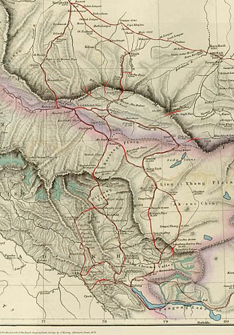

اقترح ويليام جونسون وهو موظف حكومي في هيئة المساحة الهندية "خط جونسون" في عام 1865 والذي ضم أكساي تشين لكشمير. وقتما اقتراح خط الحدود هذا كان وقت تمرد دونغان في الصين ولم تكن الصين تسيطر على أغلب منطقة سنجان، إذا لم يقدم هذا الاقتراح للصينيين. قام مهراجا كشمير ببناء حصن في شهيد الله وتمركزت قوات هناك لعدة سنوات لحماية القوافل.[27] بحلول عام 1892، كانت الصين قد أقامت علامات حدودية عند ممر كاراكورام.[28]
اقترح السير جون أرداغ وهو ضابط عسكري بريطاني في 1897 خطًا حدوديًا يمتد على طول قمة جبال كونلون شمال نهر ياركاند.[27] ويعتبر اقتراحه تعديل فعال في خط جونسون وأصبح يعرف ب"خط جونسون أرداغ".
خط ماكارتني ماكدونالد[عدل]

قدم هونغ تا تشن أحد كبار المسؤولين الصينيين في سانت بطرسبرغ في 1893 خريطة بحدود المنطقة إلى جورج ماكارتني القنصل العام البريطاني في كاشغر.[29] اقترحت بريطانيا خط جديد منقح في 1899 اقترحه ماكارتني وطورها الحاكم العام للهند اللورد إلجين. ضمت هذه الحدود سهول لينغزي تانغ التي تقع جنوب سلسلة لاكتسانغ للهند، ومنطقة أكساي تشين التي تقع شمال سلسلة لاكتسانغ للصين. اقترح المسؤولون البريطانيون ودعموا استخدام هذا الخط الممتد على طول جبال قراقرم لعدد من الأسباب، منها أن جبال قراقرم تشكل حدود طبيعية، وتضمن السيطرة البريطانية على حوض نهر السند وستشكل السيطرة الصينية على هذه المنطقة عقبة أخرى أمام التقدم الروسي في آسيا الوسطى.[30] قدم البريطانيون هذا الخط المعروف باسم خط ماكارتني ماكدونالد للصينيين في عام 1899 في مذكرة كتبها السير كلود ماكدونالد. لم ترد حكومة سلالة تشينغ الحاكمة على المذكرة.[31] ذكر بعض المعلقين أن الصين قبلت هذه الحدود.[32]
خط مكماهون[عدل]
سمى الخط على اسم هنري مكماهون وزير خارجية الهند البريطانية وكبير المفاوضين البريطانيين في مؤتمر شيملا. وقعت حكومتي لتبت وبريطانيا اتفاقية لترسيم الحدود على خط مكماهون. وقعها مكماهون نيابة عن الحكومة البريطانية ولونشين شاترا نيابة عن الحكومة التبتية.[33]
1899 إلى 1947[عدل]
اعتمد البريطانيون خط ماكدونالد ليكون خط الحدود بدأ من عام 1908،[34] لكن استخدم البريطانيون خط جونسون في عام 1911 بعد انتهاء الحرب العالمية الأولى وثورة شينهاي التي أدت إلى انهيار السلطة المركزية في الصين. لم يتخذ البريطانيون أي خطوات فعلية لإثبات سيطرتهم على الأرض.[28] عُدل خط الحدود مرة أخرى في عام 1927 عندما تخلت حكومة الهند البريطانية عن خط جونسون لصالح خط يمتد على سلسلة كاراكورام.[28] لكن لم تحدث الخرائط البريطانية وما زالت تظهر خط جونسون.[28]

أظهر الأطلس البريدي الصيني الذي نشرته حكومة الصين في بكين من عام 1917 إلى عام 1933 أن الحدود في المنطقة هي خط جونسون الذي يمتد على طول جبال كونلون.[29][32] وكذلك أطلس جامعة بكين الذي نُشر عام 1925.[35] عندما علم المسؤولون البريطانيون بأن المسؤولين السوفييت كانوا يدفعون شنغ شيكاي أمير الحرب في سنجان في 1940-1941 لاحتلال المنطقة استخدموا خط جونسون خط الحدود مرة أخرى، بدون أن تناقش هذه القضية أبدا مع حكومتي الصين أو التبت، وظلت الحدود غير واضحة عند استقلال الهند.[28][36]
منذ عام 1947[عدل]

اعتمدت حكومة الهند بعد الاستقلال عام 1947 خط جونسون خط حدودها وبالتالي ضمت أكساي تشين لها.[28] ييدأ الخط من شمال شرق جبال قراقرم ويعبر المسطحات الملحية ونهر كاراكاش ويتجه شرقًا حتى جبال كونلون ويمتدد على قممها ثم يتجه نحو الجنوب الغربي إلى بحيرة بانغونق.[21]
كتب رئيس الوزراء جواهر لال نهرو في 1 يوليو 1954 مذكرة يأمر فيها بمراجعة خرائط الهند وتحديد جميع حدودها. حتى هذه اللحظة وصفت الحدود في أكساي تشين بأنها "غير محددة".[30]
المنطقة غير صالحة للسكن تقريبًا ولا تحتوي على موارد إلا أنها ذات ذات أهمية استراتيجية بالنسبة للصين لأنها تربط التبت وسنجان. قامت جمهورية الصين الشعبية في الخمسينيات ببناء طريق بطول 1200 كيلومتر (750 ميل) يربط بين شينجيانغ وغرب التبت منها 179 كيلومترًا (112 ميل) في منطقة أكساي تشين التي تطالب بها الهند.[21][28] كان من السهل على الصينيين الوصول إلى أكساي تشين بعكس الهنود الذي يصعب عليهم الأمر.[21] لم يعلم الهنود بوجود ذلك الطريق إلا في عام 1957، وهو ما تأكد عندما ظهر الطريق في الخرائط الصينية المنشورة في عام 1958.[37] كان هذا الطريق السريع أحد محفزات الحرب الصينية الهندية عام 1962.[38]
كان الموقف الهندي كما ذكر رئيس الوزراء نهرو هو أن أكساي تشين كانت "جزءًا من منطقة لداخ في الهند لعدة قرون" وأن هذه الحدود الشمالية "ثابتة ومحددة ولا يمكن مناقشتها مع أي شخص"[21] قال رئيس الوزراء الصيني تشوان لاي إن الحدود الغربية لم ترسم أبدًا وأن خط ماكارتني ماكدونالد الذي وضع أكساي تشين ضمن الصين وهو الخط الوحيد الذي اقترح وعُرض للحكومة الصينية وأن أكساي تشين كانت بالفعل تحت سيطرة الصين. ذكر أن المفاوضات يجب أن تأخذ في الاعتبار الوضع الراهن.[21]
كشفت صور الأقمار الصناعية على خدمة جوجل إيرث في يونيو 2006 عن نموذج تضاريس بمقياس 1:500[39] لشرق أكساي تشين والتبت المجاورة بني بالقرب من بلدة هوانغيانغتان على بعد حوالي 35 كيلومترًا (22 ميلًا) جنوب غرب ينشوان عاصمة منطقة نينغشيا ذاتية الحكم في الصين.[40] [41] تزعم السلطات المحلية في نينغشيا أن نموذجها من أكساي تشين هو جزء من ساحة تدريب دبابات بنيت في عام 1998 أو 1999.[39]
ألقت القوات الهندية والصينية بالقرب من بانجونج تسو قي أغسطس 2017 الحجارة على بعضها البعض.[42][43] واجهت قوات جيش التحرير الشعبي القوات الهندية على الضفة الشمالية لبحيرة بانغونق في 11 سبتمبر 2019.[44][45]
بلغت المواجهة بين الدولتين أوجها في مايو ويونيو 2020 بالقرب من بحيرة بانغونق في اشتباك عنيف في 16 يونيو 2020 قتل فيه ما لا يقل عن 20 شخصًا من الجانب الهندي ولم يبلغ الجانب الصيني عن أي وفيات رسمية. أفادت وسائل الإعلام الحكومية الصينية عن وفاة 4 صينيين في عام 2021.[46] ادعى الجانبان حدوث استفزاز الآخر له.[47][48][42][49][50][51][52]
الجغرافية[عدل]


أكساي تشين هي إحدى المنطقتين الحدوديتين الكبيرتين المتنازع عليهما بين الهند والصين (الأخرى هي Trans-Karakoram Tract).[53][21] تدعي الهند بأن منطقة أكساي تشين هي الجزء الشرقي الأقصى من إقليم لداخ الاتحادي وتدعي الصين أن أكساي تشين جزء من منطقة سنجان الأويغورية ذاتية الحكم ومنطقة التبت ذاتية الحكم. يُعرف الخط الذي يفصل المناطق التي تسيطر عليها الصين وبين إقليم لداخ الهندي باسم خط السيطرة الفعلية وهو الخط الذي تطالب الصين بأن يكون خط الحدود بين البلدين.
تبلغ مساحة أكساي تشين حوالي 38,000 كيلومتر مربع (15,000 ميل2).[54] وهي صحراء واسعة شاهقة الارتفاع به نقطة منخفضة واحدة (نهر كاراكاش) متوسط ارتفاع المنطقة حوالي 4300 متر (14100 قدم) فوق مستوى سطح البحر. تفصل سلسلة جبال كونلون في الشمال أكساي تشين عن حوض تاريم. لا تعبر أي طرق سلسلة جبال كونلون من محافظة هوتان إنما ترتبط المنطقة مع المحافظة بالطريق الذي يعبر ممر هندوتاش.[55] تتلقى المنطقة ككل كميات قليلة من الأمطار حيث تصد جبال الهيمالايا وجبال قراقرم الأمطار.
السكان والاقتصاد[عدل]
اقتصر زوار أكساي تشين قبل عام 1950 في الغالب على المستكشفين والصيادين والبدو.[56][57][58][59]
كانت تجري بالمنطقة بعض عمليات التعدين قبل الاستكشاف الأوروبي في ستينيات القرن التاسع عشر.[58][60] انتهت هذه العمليات في الوقت الذي وصل فيه المستكشفون الأوروبيون إلى المنطقة.[60] روج البريطانيون لاستخدام أكساي تشين كطريق لتسهيل التجارة بين شبه القارة الهندية وحوض تاريم في ستينيات وسبعينيات القرن التاسع عشر بدلا من ممر كاراكورام الصعب والذي به رسوم جمركية.[61] نُوقشت فكرة الطريق المسمى خط تشانغ تشينمو في مجلس عموم المملكة المتحدة في عام 1874.[62] لكن بسبب كون الطريق أطول وأعلى ارتفاعًا من ممر كاراكورام ومروره عبر صحراء أكساي تشين المقفرة،.[61][62] توقف التجار عن استخدامه في تسعينيات القرن التاسع عشر.[63]
قامت الهند في خمسينيات القرن الماضي بجمع عينات ملح من بحيرات مختلفة في أكساي تشين لدراسة الجدوى الاقتصادية لاستخراج الملح في المنطقة.[64][65]
بنت القوات البرية للجيش التحرير الشعبي طريق إلى المنطقة والعديد من المعسكرات حتى نهاية الخمسينيات في تيانوينديان[66] وممر كونغكا[67] وهيويتان[68] وتيانشويهاي.[69] طور ذلك الطريق لاحقًا إلى طريق الصين الوطني السريع 219. حاليا يوجد عدد قليل من الشركات على طول الطريق السريع التي تخدم سائقي السيارات.[70]
أجريت مسوحات جيولوجية لمنطقة كونلون الغربية والتي تعد أكساي تشين جزءًا منها في عام 2010.[71] اكتشف في المنطقة رواسب جيدة من الرصاص والزنك ورواسب صغيرة العديد من المعادن الأخرى.[71] بدأ التعديد في جبل هوشاويون الواقع في المنطقة بالقرب من الحدود التبتية[72] في عام 2017.[73][74]
النقل[عدل]
يمر طريق الصين السريع الوطني 219 الرابط بين التبت (ولاية نغاري) وشينجيانغ (ولاية هوتان) بأكساي تشين ويربطها بالمنطقتين.
نشرت وزارة النقل الصينية خطة محدثة لشبكة الطرق السريعة الوطنية الصينية في يوليو 2022 تتضمن الطريق السريع الوطني الصيني 695 والذي يسمر بأكساي تشين ليربط مدينة لونزي في التبت ببلدة مزار في سنجان.[75][76]
فهرست المراجع[عدل]
- ^ ا ب
(a) Kashmir, region Indian subcontinent، Encyclopaedia Britannica، مؤرشف من الأصل في 2020-11-07، اطلع عليه بتاريخ 2019-08-15 (subscription required) Quote: "Kashmir, region of the northwestern Indian subcontinent ... has been the subject of dispute between India and Pakistan since the partition of the Indian subcontinent in 1947. The northern and western portions are administered by Pakistan and comprise three areas: Azad Kashmir, Gilgit, and Baltistan, the last two being part of a territory called the Northern Areas. Administered by India are the southern and southeastern portions, which constitute the state of Jammu and Kashmir but are slated to be split into two union territories.";
(b) Pletcher، Kenneth، Aksai Chin, Plateau Region, Asia، Encyclopaedia Britannica، مؤرشف من الأصل في 2024-06-08، اطلع عليه بتاريخ 2019-08-16 (subscription required) Quote: "Aksai Chin, Chinese (Pinyin) Aksayqin, portion of the Kashmir region, at the northernmost extent of the Indian subcontinent in south-central Asia. It constitutes nearly all the territory of the Chinese-administered sector of Kashmir that is claimed by India to be part of the Ladakh area of Jammu and Kashmir state.";
(c) "Kashmir"، Encyclopedia Americana، Scholastic Library Publishing، 2006، ص. 328، ISBN:978-0-7172-0139-6، مؤرشف من الأصل في 2024-04-08 C. E Bosworth, University of Manchester Quote: "KASHMIR, kash'mer, the northernmost region of the Indian subcontinent, administered partlv by India, partly by Pakistan, and partly by China. The region has been the subject of a bitter dispute between India and Pakistan since they became independent in 1947";
(d) Osmańczyk، Edmund Jan (2003)، Encyclopedia of the United Nations and International Agreements: G to M، Taylor & Francis، ص. 1191–، ISBN:978-0-415-93922-5، مؤرشف من الأصل في 2024-04-08 Quote: "Jammu and Kashmir: Territory in northwestern India, subject to a dispute between India and Pakistan. It has borders with Pakistan and China."
(e) Talbot، Ian (2016)، A History of Modern South Asia: Politics, States, Diasporas، Yale University Press، ص. 28–29، ISBN:978-0-300-19694-8، مؤرشف من الأصل في 2024-04-08 Quote: "We move from a disputed international border to a dotted line on the map that represents a military border not recognized in international law. The line of control separates the Indian and Pakistani administered areas of the former Princely State of Jammu and Kashmir.";
(f) Skutsch، Carl (2015) [2007]، "China: Border War with India, 1962"، في Ciment، James (المحرر)، Encyclopedia of Conflicts Since World War II (ط. 2nd)، London and New York: Routledge، ص. 573، ISBN:978-0-7656-8005-1،The situation between the two nations was complicated by the 1957–1959 uprising by Tibetans against Chinese rule. Refugees poured across the Indian border, and the Indian public was outraged. Any compromise with China on the border issue became impossible. Similarly, China was offended that India had given political asylum to the Dalai Lama when he fled across the border in March 1959. In late 1959, there were shots fired between border patrols operating along both the ill-defined McMahon Line and in the Aksai Chin.
(g) Clary، Christopher (2022)، The Difficult Politics of Peace: Rivalry in Modern South Asia، Oxford and New York: Oxford University Press، ص. 109، ISBN:9780197638408،Territorial Dispute: The situation along the Sino-Indian frontier continued to worsen. In late July (1959), an Indian reconnaissance patrol was blocked, "apprehended," and eventually expelled after three weeks in custody at the hands of a larger Chinese force near Khurnak Fort in Aksai Chin. ... Circumstances worsened further in October 1959, when a major class at Kongka Pass in eastern Ladakh led to nine dead and ten captured Indian border personnel, making it by far the most serious Sino-Indian class since India's independence.
(h) Bose، Sumantra (2009)، Kashmir: Roots of Conflict, Paths to Peace، Harvard University Press، ص. 294, 291, 293، ISBN:978-0-674-02855-5، مؤرشف من الأصل في 2024-04-08 Quote: "J&K: Jammu and Kashmir. The former princely state that is the subject of the Kashmir dispute. Besides IJK (Indian-controlled Jammu and Kashmir. The larger and more populous part of the former princely state. It has a population of slightly over 10 million, and comprises three regions: Kashmir Valley, Jammu, and Ladakh.) and AJK ('Azad" (Free) Jammu and Kashmir. The more populous part of Pakistani-controlled J&K, with a population of approximately 2.5 million.), it includes the sparsely populated "Northern Areas" of Gilgit and Baltistan, remote mountainous regions which are directly administered, unlike AJK, by the Pakistani central authorities, and some high-altitude uninhabitable tracts under Chinese control."
(i) Fisher، Michael H. (2018)، An Environmental History of India: From Earliest Times to the Twenty-First Century، Cambridge University Press، ص. 166، ISBN:978-1-107-11162-2، مؤرشف من الأصل في 2024-04-08 Quote: "Kashmir’s identity remains hotly disputed with a UN-supervised “Line of Control” still separating Pakistani-held Azad (“Free”) Kashmir from Indian-held Kashmir.";
(j) Snedden، Christopher (2015)، Understanding Kashmir and Kashmiris، Oxford University Press، ص. 10، ISBN:978-1-84904-621-3، مؤرشف من الأصل في 2024-04-08 Quote:"Some politicised terms also are used to describe parts of J&K. These terms include the words 'occupied' and 'held'." - ^ ا ب ج د ه 夏征农; 陈至立, eds. (Sep 2009). 辞海:第六版彩图本 [Cihai (Sixth Edition in Color)] (بالصينية). 上海. شانغهاي: 上海辞书出版社. Shanghai Lexicographical Publishing House. p. 0008. ISBN:9787532628599.
阿克赛钦 地名区。维吾尔语意即"中国的白石滩"。在新疆维吾尔自治区和田县南部、喀喇昆仑山和昆仑山间。
- ^ ا ب ج د van Driem، George L. (25 مايو 2021). Ethnolinguistic Prehistory: The Peopling of the World from the Perspective of Language, Genes and Material Culture. BRILL. ص. 53. ISBN:978-90-04-44837-7. مؤرشف من الأصل في 2023-09-28.
- ^ ا ب ج د Government of Punjab (1862). Report on the Trade and Resources of the Countries on the North-western Boundary of British India. Lahore: Government Press. ص. xxii. c. مؤرشف من الأصل في 2023-09-28.
the "Aksai Chin," or as the term implies the great Chinese white desert or plain.
- ^ ا ب ج د Journal of the Asiatic Society of Bengal. Bishop's College Press. 1868. ص. 50. مؤرشف من الأصل في 2023-09-29.
the Akzai Chin or White Desert
- ^ ا ب ج د Kaminsky، Arnold P.؛ Long، Roger D. (23 سبتمبر 2011). India Today: An Encyclopedia of Life in the Republic [2 volumes]: An Encyclopedia of Life in the Republic. ABC-CLIO. ص. 23. ISBN:978-0-313-37463-0. مؤرشف من الأصل في 2020-04-05. اطلع عليه بتاريخ 2020-01-11.
Aksai Chin (as Uyghur name meaning "desert of white stones")
- ^ ا ب ج د Sven Anders Hedin؛ Nils Peter Ambolt (1967). Central Asia Atlas, Memoir on Maps: Index of geographical names, by D.M. Farquhar, G. Jarring and E. Norin. Sven Hedin Foundation, Statens etnografiska museum. ص. 12. مؤرشف من الأصل في 2023-09-29.
Aksai Chin, region between the K'unlun main range and the Loqzung Mountains: T. eq say 'white gravelly plain' + cin '(of) China' (Cin, earliest designation by which China was known in Central Asia).
- ^ ا ب ج د Bertil Lintner (25 يناير 2018). China's India War: Collision Course on the Roof of the World. OUP India. ص. 85. ISBN:978-0-19-909163-8. مؤرشف من الأصل في 2023-09-27.
The name Aksai Chin means 'the desert of white stones'
- ^ ا ب ج د تشوان لاي (Chou En-Lai) (15 Nov 1962). 国务院总理周恩来就中印边界問題致亚非国家領导人的信 (PDF). 中华人民共和国国务院公报 (Bulletin of the State Council of PRC) (بالصينية): 228. Archived (PDF) from the original on 2015-06-13. Retrieved 2019-12-30.
在西段,印度政府提出爭議的传统习惯綫以东和以北的地区,历来是屬于中国的。这个地区主要包括中国新疆所屬的阿克賽欽地区和西藏阿里地区的一部分,面积共为三万三千平方公里,相当于一个比利时或三个黎巴嫩。这个地区虽然人烟稀少,却历来是联結新疆和西藏阿里的交通命脉。新疆的柯尔克孜族和維吾尔族的牧民經常在这一带放牧。阿克賽欽这个地名就是維吾尔語"中国的白石滩"的意思。这块地方一直到現在是在中国的管轄之下。
{{استشهاد بدورية محكمة}}: الوسيط غير المعروف|بواسطة=تم تجاهله يقترح استخدام|عبر=(help) - ^ ا ب ج د Gurdip Singh Kler (1995). Unsung Battles of 1962. Lancer Publishers. ص. 156. ISBN:978-1-897829-09-7. مؤرشف من الأصل في 2023-09-28.
Aksai Chin - the name, means the desert of white stones.
- ^ ا ب ج د Sanjeev Kumar Bhasin (2006). Amazing Land Ladakh: Places, People, and Culture. Indus Publishing. ص. 61. ISBN:978-81-7387-186-3. مؤرشف من الأصل في 2023-09-28.
The Aksai Chin (desert of white stones)
- ^ ا ب ج د Bob Butalia (30 سبتمبر 2015). In the Shadow of Destiny. Partridge Publishing India. ص. 271. ISBN:978-1-4828-5791-7. مؤرشف من الأصل في 2023-09-28.
'Aksai Chin' in translation means 'White Brook Pass'.
- ^ ا ب Geeta Kochhar (19 مارس 2018). China's Foreign Relations and Security Dimensions. Taylor & Francis. ص. 40–. ISBN:978-0-429-01748-3. مؤرشف من الأصل في 2023-09-28.
The etymology of Aksai Chin is uncertain. Although 'Aksai' is a Turk term for 'white brooks', it is widely believed that the word 'chin' has nothing to do with China.
- ^ ا ب ج د Harish Kapadia (مارس 2002). High Himalaya Unknown Valleys. Indus Publishing. ص. 309. ISBN:978-81-7387-117-7. مؤرشف من الأصل في 2023-09-28.
Aksai Chin, (Aksai: eastern, Chin: China) ... Most of the names were found to be distinctly Yarkandi.
- ^ ا ب "ئاقساي چىنمۇ ياكى ئاقساي چۆلمۇ؟" [Is Aksai True or Aksai Desert?] (بالأويغورية). إذاعة آسيا الحرة. 22 Jun 2010. Archived from the original on 2010-09-05. Retrieved 2020-01-18.
ماقالە يازغۇچى داۋاملاشتۇرۇپ: بۇ تېررىتورىيىنىڭ نامى تۈرك تىلىدا، "ئاقساي چىن " دېيىلىدۇ، بۇ ئىسىمدىكى "چىن" سۆزى جۇڭگونى كۆرسىتىدۇ، ئېيتىشلارغا ئاساسلانغاندا، بۇ سۆزنىڭ مەنىسى – " جۇڭگونىڭ ئاق تاشلىق جىلغىسى ياكى جۇڭگونىڭ ئاق تاشلىق سېيى" دېگەنلىك بولىدۇ دەيدۇ. [The author goes on to say that the name of the territory is in Turkish, "Aksai Chin", and the word "Chin" in that name means China, and it is said that the word means "White Valley of China or China's White River".]
- ^ ا ب Mehra, An "agreed" frontier (1992), p. 79: "The name 'Aksai Chin' occurred on a map captioned 'Rough sketch of caravan routes through the Pamir steppes and Yarkand, from information collected' from Mahomed Ameen Yarkandi [Mohammed Amin], 'late guide' to the well-known Schlagintweit brothers. This was compiled in the Quartermaster-General's office in 1862. The sketch, which offered no details this side of the Kunlun, had 'Aksai Chin' written right across the blank space south of the Kunlun range. Mahomed Ameen had noted that 'beyond the pass (north of the Chang Chenmo) lies the Aksai Chin. ... it extends to Chinese territory to the East.'"
- ^ Brescius، Moritz von (2019)، German Science in the Age of Empire، Cambridge University Press، ص. 197–199 (including Map 5.2: 'Rough Sketch of Caravan Routes through the Pamir Steppes and Yarkund, from Information Coll، ISBN:978-1-108-42732-6، مؤرشف من الأصل في 2023-09-28
- ^ Brescius، Moritz von (2019)، German Science in the Age of Empire، Cambridge University Press، ص. 197–199 (including Map 5.2: 'Rough Sketch of Caravan Routes through the Pamir Steppes and Yarkund, from Information Collected from Mahomed Ameen Yarkundi, Late Guide to Messrs. De Schlagintweit')، ISBN:978-1-108-42732-6، مؤرشف من الأصل في 2023-09-28
- ^ Mehra, An "agreed" frontier (1992), p. 11.
- ^ ا ب ج د ه و ز Maxwell، Neville (1970). India's China War. New York: Pantheon. ص. 3. مؤرشف من الأصل في 2013-11-01. اطلع عليه بتاريخ 2020-01-04.
At 17,000 feet elevation, the desolation of Aksai Chin had no human importance other than an ancient trade route that crossed over it, providing a brief pass during summer for caravans of yaks from Sinkiang to Tibet that carried silk, jade, hemp, salt
- ^ Gaver، John W. (2011). Protracted Contest: Sino-Indian Rivalry in the Twentieth Century. University of Washington Press. ص. 83. ISBN:978-0295801209. مؤرشف من الأصل في 2023-09-29. اطلع عليه بتاريخ 2020-01-04.
The westerly route via Aksai Chin was an old caravan route and in many ways the best. It was the only route that was open year-round, throughout both the winter and the monsoon season. The Dzungar army that had reached Lhasa in 1717 ... had followed this route.
- ^ Maxwell, India's China War 1970، صفحة 24.
- ^ The Sino-Indian Border Disputes, by Alfred P. Rubin, The International and Comparative Law Quarterly, Vol. 9, No. 1. (Jan. 1960), pp. 96–125, جايستور 756256.
- ^ Maxwell, India's China War 1970، صفحة 25–26.
- ^ Maxwell, India's China War 1970، صفحة 26.
- ^ ا ب Woodman 1969، صفحات 101, 360ff.
- ^ ا ب ج د ه و ز Calvin، James Barnard (أبريل 1984). "The China-India Border War". Marine Corps Command and Staff College. مؤرشف من الأصل في 2012-06-04.
- ^ ا ب ج Woodman 1969، صفحات 73, 78.
- ^ ا ب Noorani، A.G. (30 أغسطس – 12 سبتمبر 2003)، "Fact of History"، Frontline، Madras: The Hindu group، ج. 26، مؤرشف من الأصل في 2011-10-02، اطلع عليه بتاريخ 2011-08-24
- ^ Woodman 1969، صفحة 102: The proposed boundary seems never to have been considered in the same form again until Alastair Lamb revived it in 1964
- ^ ا ب Verma، Virendra Sahai (2006). "Sino-Indian Border Dispute at Aksai Chin – A Middle Path For Resolution". Journal of Development Alternatives and Area Studies. ج. 25 ع. 3: 6–8. ISSN:1651-9728.
- ^ Rao، Veeranki Maheswara (2003). Tribal Women of Arunachal Pradesh: Socio-economic Status. Mittal Publications. ص. 60–. ISBN:978-81-7099-909-6. مؤرشف من الأصل في 2023-07-28. اطلع عليه بتاريخ 2017-05-25.
- ^ Woodman 1969، صفحة 79.
- ^ Fisher، Margaret W.؛ Rose، Leo E.؛ Huttenback، Robert A. (1963). Himalayan Battleground: Sino-Indian Rivalry in Ladakh. Praeger. ص. 101. مؤرشف من الأصل في 2014-09-30. اطلع عليه بتاريخ 2017-08-24.
{{استشهاد بكتاب}}: يحتوي الاستشهاد على وسيط غير معروف وفارغ:|بواسطة=(مساعدة)[بحاجة لمُعرِّف الكتاب] - ^ Orton، Anna. India's Borderland Disputes: China, Pakistan, Bangladesh and Nepal. Epitome Books. ص. 24. ISBN:978-93-80297-25-5. مؤرشف من الأصل في 2023-09-29.
- ^ China's Decision for War with India in 1962 by John W. Garver نسخة محفوظة 26 مارس 2009 في Wayback Machine
- ^ Guo، Rongxing (2007). Territorial Disputes and Resource Management. Nova Science Publishers. ص. 43. ISBN:978-1-60021-445-5. مؤرشف من الأصل في 2023-09-27. اطلع عليه بتاريخ 2019-06-10.
- ^ ا ب "Chinese X-file not so mysterious after all". ذي إيج. Melbourne. 23 يوليو 2006. مؤرشف من الأصل في 2009-01-13. اطلع عليه بتاريخ 2008-12-17.
- ^ "From sky, see how China builds model of Indian border 2400 km away". 5 أغسطس 2006. مؤرشف من الأصل في 2011-01-02. اطلع عليه بتاريخ 2009-07-08.
- ^ Google Earth Community posting نسخة محفوظة 8 ديسمبر 2008 في Wayback Machine, 10 April 2007
- ^ ا ب 費風 (11 May 2020). 中印邊境再爆衝突 150士兵毆鬥釀12傷. Hong Kong Economic Times (بالصينية التقليدية). Archived from the original on 2024-04-18. Retrieved 2020-05-16.
消息指,第一起事件發生於5月5日至6日,在中印邊境的班公錯湖(Pangong Tso )地區,當時解放軍的「侵略性巡邏」(aggressive patrolling)被印度軍方阻攔。「結果發生了混亂,雙方都有一些士兵受傷。」{...}2017年8月,兩國軍隊曾於拉達克地區班公湖附近爆發衝突,當時雙方擲石攻擊對方,雙方均有人受傷,最終兩軍在半小時後退回各自據點。
- ^ Sushant Singh (20 مايو 2020). "India-China conflict in Ladakh: The importance of the Pangong Tso lake". إكسبرس الهندية. مؤرشف من الأصل في 2024-06-12. اطلع عليه بتاريخ 2020-05-21.
- ^ "Indian, Chinese Troops Face-off in Ladakh Ahead of Modi-Xi Summit, Army Says Tension De-escalated". News18. 12 سبتمبر 2019. مؤرشف من الأصل في 2019-11-07. اطلع عليه بتاريخ 2020-05-12.
- ^ Chang Ya-Han 張雅涵, ed. (10 Mar 2020). 中國在西藏地區軍演頻繁 牽動中印未來危機應對. Radio Taiwan International (بالصينية المبسطة). Archived from the original on 2020-03-11. Retrieved 2020-05-16.
{{استشهاد ويب}}: صيانة الاستشهاد: لغة غير مدعومة (link) - ^ "Ladakh: China reveals soldier deaths in India border clash". BBC News (بالإنجليزية البريطانية). 19 Feb 2021. Archived from the original on 2022-12-13. Retrieved 2022-02-26.
- ^ "India China news live: At least 20 Indian Army personnel killed in violent face-off in Ladakh's Galwan Valley". تايمز أوف إينديا. مؤرشف من الأصل في 2024-05-13.
- ^ Dinakar Peri (10 مايو 2020). "Indian, Chinese troops face off in Eastern Ladakh, Sikkim". الصحيفة الهندوسية. مؤرشف من الأصل في 2020-05-12. اطلع عليه بتاريخ 2020-05-13.
- ^ "Chinese military bolsters troops in Aksai Chin region in Sino-India border: Report". The Economic Times. 19 مايو 2020. مؤرشف من الأصل في 2020-05-19. اطلع عليه بتاريخ 2020-05-19.
On May 5, around 250 Indian and Chinese army personnel clashed in Pangong Tso lake area in Eastern Ladakh.
- ^ "Chinese, Indian troops engage in border conflicts". Taiwan News. 25 مايو 2020. مؤرشف من الأصل في 2021-09-21. اطلع عليه بتاريخ 2020-05-26.
- ^ Drake Long (22 مايو 2020). "India Voices Unusual Criticism of China's Conduct in South China Sea". إذاعة آسيا الحرة. مؤرشف من الأصل في 2020-05-23. اطلع عليه بتاريخ 2020-05-27.
Chinese and Indian troops clashed on May 5 over road construction the Indian side was completing at Pangong Tso, a glacial lake bordering Ladakh and Tibet.
- ^ "Transcript of Media Briefing by Official Spokesperson (May 21, 2020)". وزارة الشؤون الخارجية (الهند). 21 مايو 2020. مؤرشف من الأصل في 2023-09-28. اطلع عليه بتاريخ 2020-05-27.
- ^ "Signing with the Red Chinese". تايم (مجلة). 15 مارس 1963. مؤرشف من الأصل في 2013-08-24. اطلع عليه بتاريخ 2019-10-28.
- ^ "Aksai Chin". الموسوعة البريطانية. 2013. مؤرشف من الأصل في 2024-06-08. اطلع عليه بتاريخ 2021-06-11.
At the conclusion of the conflict, China retained control of about 14,700 square miles (38,000 square km) of territory in Aksai Chin.
- ^ Xinjiang Uyghur Autonomous Region Road Atlas (中国分省公路丛书:新疆维吾尔自治区), published by 星球地图出版社 Xingqiu Ditu Chubanshe, 2008, (ردمك 978-7-80212-469-1). Map of Hotan Prefecture, pp. 18–19.
- ^ Chandran، D. Suba؛ Singh، Bhavna (21 أكتوبر 2015). India, China and Sub-regional Connectivities in South Asia. SAGE Publications India. ISBN:9789351503262. مؤرشف من الأصل في 2023-09-22.
- ^ W.F. Van Eekelen (11 ديسمبر 2013). Indian Foreign Policy and the Border Dispute with China. Springer. ISBN:9789401765558. مؤرشف من الأصل في 2023-09-28. اطلع عليه بتاريخ 2019-12-13.
Neither party exercised a great extent of administration in Aksai Chin, but the occasional explorer, big-game hunter or nomad from India may be sufficient to establish continuity of title.
- ^ ا ب Steven A. Hoffmann (20 أبريل 2018). India and the China Crisis. Univ of California Press. ص. 12. ISBN:978-0-520-30172-6. مؤرشف من الأصل في 2023-09-29.
There was jade mining from the Sinkiang side, and some ancient (if secondary) trade routes crossed it. But that was all
- ^ Lamb، Alastair (1964). The China-India Border: The Origins of the Disputed Boundaries. Chatham House Online Archive. Oxford University Press. ص. 112. مؤرشف من الأصل في 2023-05-06.
From 1927 to 1950, of course, Aksai Chin was a region of absolutely absolutely no importance. [...] no one visited it except the occasional explorer, big-game hunter and nomad.
- ^ ا ب Robert Shaw (1871). Visits to High Tartary, Yârkand, and Kâshgar (formerly Chinese Tartary): And Return Journey Over the Karakoram Pass. J. Murray. ص. 98. مؤرشف من الأصل في 2023-09-28.
[Oct 29] beginning of the soda-plain [Oct 30] Karakash River [Nov 3] At a corner on the south side there is a piece of path with a bit of wall built up to support it, and yesterday we passed a group of stone huts: all signs that this road was once in use. (We found afterwards that this valley had formerly been frequented by the Chinese, who objected jade from hence. This industry is now extinct, as the Mussulmans of Tookistan have no taste for ornaments of this stone.) [Nov 5] plains full of salt craters
- ^ ا ب Harish Kohli (2000). Across the Frozen Himalaya: The Epic Winter Ski Traverse from Karakoram to Lipu Lekh. Indus Publishing. ص. 86–87. ISBN:978-81-7387-106-1. مؤرشف من الأصل في 2023-09-27.
the five difficult passes through the Karakorams posed a barrier ... Cayley reconnoitred a route that went through the Changchenmo ranges ... if anything these new passes were higher than the ones they replaced, and the land in between them was also higher. ... The route had another advantage in that trade from British India could flow through Kulu via Changchenmo to Yarkand, completely bypassing the customs officials of the Maharaja at Leh.
- ^ ا ب Accounts and Papers. East India. House of Commons, British Parliament. ج. XLIX. 1874. ص. 23–33. مؤرشف من الأصل في 2023-09-28.
(p26) The Changchenmo line ... The extra distance and the sojourn for 5 days longer in such a desolate tract (p33) Every endeavour has been made to improve the Changchenmo route—serais having been built at some places, and depots of grain established as far as Gogra
- ^ A. E. Ward (1896). The Tourist's And—sportsman's Guide to Kashmir and Ladak, &c. Thacker, Spink. ص. 106–107. مؤرشف من الأصل في 2023-09-27.
Joining the left bank of the river opposite to Kyam are the Silung Yokma, Silung Burma and Silung Kongma. ... cross the Changchenmo valley journey up the Kiepsang stream ... The traders have now almost entirely given up the Changchenmo-Shahidula route to Yarkand.
- ^ Brig Amar Cheema, VSM (31 مارس 2015). The Crimson Chinar: The Kashmir Conflict: A Politico Military Perspective. Lancer Publishers. ص. 157–158. ISBN:978-81-7062-301-4. مؤرشف من الأصل في 2023-09-28.
...though neither side had any physical presence there. The advantage India had was that she administered the grazing grounds and even collected salt from Amtogor Lake, deep in Aksai Chin.
- ^ Council of Scientific & Industrial Research (India) (1958). Technical Report. ص. 127. مؤرشف من الأصل في 2023-09-22.
Brines from (i) Pong Kong, (ii) Sarigh Jilgang Kol and (iii) Amtogor lakes were examined for their suitability for salt manufacture. The brines from the first two sources have been found to be uneconomical for salt manufacture.
- ^ "Indian, Chinese armies decide to improve ties at functional level". News18. 2 يناير 2016. مؤرشف من الأصل في 2019-12-14. اطلع عليه بتاريخ 2017-09-14.
- ^ "在海拔5070米的空喀山口哨卡某边防团政委宗建明和官兵深情的拥抱" [Zong Jianming, political commissar of a border defense regiment, and the officers and soldiers at the empty Kazan checkpoint at an altitude of 5,070 meters affectionately embrace]. سينا (شركة) Military. 17 سبتمبر 2009. مؤرشف من الأصل في 2019-12-14. اطلع عليه بتاريخ 2019-12-14.
- ^ 颜玮珏 (30 سبتمبر 2013). 马丹宁 (المحرر). "Keeping watch over highest mountain". الصين يوميا. مؤرشف من الأصل في 2019-12-29. اطلع عليه بتاريخ 2019-12-29.
Soldiers pose for a picture at the Heweitan sentry post on Karakorum Mountains in Xinjiang Uygur autonomous region, Sept 30.
- ^ 陈金财; 徐俊 (7 Dec 2016). 杜麒麟; 孙和静 (eds.). "走进天路兵站甜水海 体会官兵生活的苦与乐" [Enter the army outpost Tianshuihai on the skyward road, experience the hardship and joy of army life]. 中国陆军网 [China Army Net] (بالصينية). People's Liberation Army News and Dissemination Center. Archived from the original on 2019-12-13. Retrieved 2019-12-13.
从1959年建站起,兵站所有的生活用水,都要到90公里外的"死人沟"泉水湖去拉,来回一趟至少6个小时,如果到了冬季,还得破冰取水。[Since the establishment of the station in 1959, all domestic water in the military depot has to be pulled from the "Deadrengou" spring lake 90 kilometers away. It takes at least six hours to go back and forth. If it is winter, the ice must be broken for water.]
- ^ 罗俊, ed. (18 Nov 2011). "新疆死人沟——窒息的环境 惊险的美" [Death Valley in Xinjiang-a suffocating environment, breathtaking beauty] (بالصينية). صحيفة الشعب اليومية Oversea Edition. Archived from the original on 2013-01-21. Retrieved 2019-12-13.
死人沟只有五顶帐篷,能为过往行人提供简单的饭菜面食。对面有一个兵站。[There are only five tents in the Dead Valley, which can provide simple meals and pasta for the passersby. There is a military station opposite.]
- ^ ا ب 张作衡 (Sep 2017). "2017年矿产资源地质调查新进展" [New progress in geological survey of mineral resources in 2017] (PDF) (بالصينية). China Geological Survey. p. 27. Archived (PDF) from the original on 2020-01-25. Retrieved 2020-01-16.
新疆西昆仑地区铅锌找矿取得一批新发现...火烧云铅锌矿已提交333以上铅锌资源储量1704万吨...调查发现多宝山、萨岔口、团结峰、甜水海、鸡冠石、天柱山等10余处中小型矿床 [A number of new discoveries have been made in lead-zinc prospecting in the West Kunlun area of Xinjiang... The Huoshaoyun lead-zinc deposit has submitted a lead-zinc resource reserve of more than 333 million tons... Tianzhushan and more than ten small and medium-sized deposits]
- ^ Gao، Ting؛ Yi، Huan؛ Han، Ling؛ Ren، Guangli؛ Yang، Min (2018). "Detection of Pb–Zn mineralization zones in west Kunlun using Landsat 8 and ASTER remote sensing data". Journal of Applied Remote Sensing. ج. 12 ع. 2: 1. Bibcode:2018JARS...12b6018Y. DOI:10.1117/1.JRS.12.026018. ISSN:1931-3195.
- ^ Ma، Echo (24 فبراير 2017). "Development starts on China's largest lead-zinc mine". Fastmarkets. Metal Bulletin. مؤرشف من الأصل في 2019-12-28. اطلع عليه بتاريخ 2019-12-28.
The Huoshaoyun lead-zinc mine site in Xinjiang province, 5,500 metres above sea level, is reported to contain about 19 million tonnes of lead and zinc, with an average grade of 30%, according to the China Geological Survey. It will be the world's seventh-largest lead-zinc mine.
- ^ Geological Survey in China (15 يوليو 2019). "The Prospecting Space of Huoshaoyun lead-Zinc Mine in Xinjiang extends to the periphery by nearly 15 km-Shanghai Metals Market". Shanghai Metals Market. مؤرشف من الأصل في 2019-12-28. اطلع عليه بتاريخ 2019-12-28.
- ^ Laura، Zhou (20 يوليو 2022). "China's highway plans near border expected to spark concern in India". South China Morning Post. مؤرشف من الأصل في 2022-07-21. اطلع عليه بتاريخ 2023-09-04.
- ^ (بالصينية). Ministry of Transport of China. 4 Jul 2022 – via ويكي مصدر.
ثبت المراجع[عدل]
- Maxwell، Neville (1970)، India's China War، Pantheon Books، ISBN:978-0-394-47051-1، مؤرشف من الأصل في 2024-06-16
- Mehra، Parshotam (1992)، An "agreed" frontier: Ladakh and India's northernmost borders, 1846-1947، Oxford University Press، ISBN:9780195627589، مؤرشف من الأصل في 2023-07-11
- Woodman، Dorothy (1969)، Himalayan Frontiers: A Political Review of British, Chinese, Indian, and Russian Rivalries، Praeger
{{استشهاد}}: الوسيط غير المعروف|بواسطة=تم تجاهله يقترح استخدام|عبر=(مساعدة) - Sino-Indian Border Defenses Chushul Area (CIA, 1963)
روابط خارجية[عدل]
| مصادر مكتبية عن أكساي تشين |
| ابحث عن Aksai Chin في ويكاموس. |
- China and Kashmir, by Jabin T. Jacob, published in The Future of Kashmir, special issue of ACDIS Swords and Ploughshares, Program in Arms Control, Disarmament, and International Security, University of Illinois, winter 2007–8.
- Conflict in Kashmir: Selected Internet Resources by the Library, University of California, Berkeley, USA؛ جامعة كاليفورنيا (بركلي) Library Bibliographies and Web-Bibliographies list
- Two maps of Kashmir: maps showing the Indian and Pakistani positions on the border.
| أكساي تشين في المشاريع الشقيقة: | |
| |
- الاستشهاد بمصادر باللغة الصينية المبسطة (zh hans)
- أكساي تشين
- الحدود الصينية الهندية
- العلاقات الصينية الباكستانية
- العلاقات الصينية الهندية
- النزاعات الداخلية في الصين
- تاريخ الصين
- تاريخ جامو وكشمير
- تاريخ جمهورية الهند
- تاريخ لداخ
- جغرافيا التبت
- جغرافيا سنجان
- جغرافيا لداخ
- جغرافيا منطقة التبت ذاتية الحكم
- لداخ
- مناطق نزاع
- نزاعات الهند الإقليمية