The municipality (originally the parish) is named after the old Nes farm (Old Norse: Nes—now the village of Nesbyen), since the first church was built there. The name is identical with the word nes which means headland. Prior to 1889, the name was spelled "Næs".
The coat-of-arms is from modern times. They were granted on 29 June 1979. The arms show a yellow-gold triangle pointing to the left on a red background. This represents a sandy peninsula or headlands (yellow triangle) formed by the confluence of two rivers: Rukkedøla and Hallingdalselva. The design is canting because this is what the name of the municipality means (see above under the name).[4]
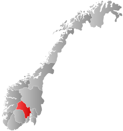
The municipality lies in the valley and traditional district of Hallingdal. It is bordered on the north by the municipality of Gol, on the east by Sør-Aurdal, on the southeast by Flå, on the southwest by Nore og Uvdal, and to the west by Ål.
The majority of the residents live in the villages of Nesbyen, Espeset, Eidal, Sjong, Børtnes, Bromma, Svenkerud, and Liodden.
View from Liodden Camping
Nesbyen has a boreal climate, bordering on a humid continental climate, with fairly warm and pleasant summers and cold winters. On 20 June 1970, Nesbyen recorded the all-time high for Norway 35.6 °C (96.1 °F); the record low −38 °C (−36 °F) was recorded 13 January 1914.[7] The weather station Nesbyen-Todokk started recording in 2003; there have been weather stations in Nesbyen recording temperature since 1897.
| Climate data for Nesbyen - Todokk 1991-2020 (166 m, extremes 1897-2020 includes earlier stations, sunhrs from Oslo)
|
| Month
|
Jan
|
Feb
|
Mar
|
Apr
|
May
|
Jun
|
Jul
|
Aug
|
Sep
|
Oct
|
Nov
|
Dec
|
Year
|
| Record high °C (°F)
|
13
(55)
|
14.3
(57.7)
|
18.9
(66.0)
|
24.8
(76.6)
|
30.1
(86.2)
|
35.6
(96.1)
|
34.6
(94.3)
|
34.6
(94.3)
|
27.8
(82.0)
|
22
(72)
|
16
(61)
|
12.8
(55.0)
|
35.6
(96.1)
|
| Mean daily maximum °C (°F)
|
−4
(25)
|
−0.7
(30.7)
|
5.8
(42.4)
|
11.6
(52.9)
|
16.6
(61.9)
|
20.9
(69.6)
|
22.9
(73.2)
|
20.7
(69.3)
|
16.2
(61.2)
|
8.1
(46.6)
|
1.1
(34.0)
|
−2.8
(27.0)
|
9.7
(49.5)
|
| Daily mean °C (°F)
|
−7.4
(18.7)
|
−5.8
(21.6)
|
−0.6
(30.9)
|
4.4
(39.9)
|
9.4
(48.9)
|
13.8
(56.8)
|
16.1
(61.0)
|
14.2
(57.6)
|
9.7
(49.5)
|
3.1
(37.6)
|
−2.5
(27.5)
|
−7.2
(19.0)
|
3.9
(39.1)
|
| Mean daily minimum °C (°F)
|
−11.3
(11.7)
|
−9.6
(14.7)
|
−5.6
(21.9)
|
−1.2
(29.8)
|
3
(37)
|
7.7
(45.9)
|
10.4
(50.7)
|
9.2
(48.6)
|
5.1
(41.2)
|
0.1
(32.2)
|
−4.9
(23.2)
|
−9.8
(14.4)
|
−0.6
(30.9)
|
| Record low °C (°F)
|
−38
(−36)
|
−37.2
(−35.0)
|
−29.8
(−21.6)
|
−19.8
(−3.6)
|
−8.6
(16.5)
|
−4.7
(23.5)
|
0
(32)
|
−2.1
(28.2)
|
−6.8
(19.8)
|
−22
(−8)
|
−27.4
(−17.3)
|
−34.5
(−30.1)
|
−38
(−36)
|
| Average precipitation mm (inches)
|
31.5
(1.24)
|
19.5
(0.77)
|
19.3
(0.76)
|
24.7
(0.97)
|
42.7
(1.68)
|
59.3
(2.33)
|
75.7
(2.98)
|
72
(2.8)
|
48.9
(1.93)
|
45.5
(1.79)
|
39.1
(1.54)
|
30.5
(1.20)
|
508.7
(19.99)
|
| Mean monthly sunshine hours
|
45.1
|
77.6
|
146.5
|
182.0
|
248.0
|
230.3
|
244.1
|
203.8
|
150.1
|
94
|
50.9
|
40.0
|
1,712.4
|
| Source 1: yr.no (mean, precipitation)[8]
|
| Source 2: Meteostat (avg high/low temperature) [9]
|
 Trøymstugua from 1645
Hallingdal Museum (Hallingdal Folkemuseum) is located in Nesbyen. Hallingdal Folk Museum, founded in 1899, is one of the oldest open air museums in Norway. It has a large and unique collection of buildings and artifacts from farms in Hallingdal. Special mentions is houses like Staveloftet, built around 1340, from the Stave farm and Trøymstua from about 1645, coming from Hemsedal.
There is an old meteor crater just north of Nesbyen (about 6 kilometres north and then 4 kilometres into the woods). About 650 million years ago, a 200-to-300-metre (660 to 980 ft) meteorite struck this area. This resulted in a 5-kilometre (3.1 mi) impact crater and an enormous amount of outpouring of energy by the impact.
 Margarete Bonnevie
Wikimedia Commons has media related to
Nesbyen.
Look up
Nes in Wiktionary, the free dictionary.