West Texas: Difference between revisions
→Politics: typo in the data (2020). |
|||
| (12 intermediate revisions by 4 users not shown) | |||
| Line 11: | Line 11: | ||
| nickname = |
| nickname = |
||
| coordinates = |
| coordinates = |
||
|population_as_of |
| population_as_of = |
||
|population_total |
| population_total = |
||
| subdivision_type = [[List of sovereign states|Country]] |
| subdivision_type = [[List of sovereign states|Country]] |
||
| subdivision_name = [[United States]] |
| subdivision_name = [[United States]] |
||
| Line 33: | Line 33: | ||
West Texas receives much less rainfall than the rest of Texas and has an arid or semiarid climate, requiring most of its scant agriculture to depend heavily on irrigation.<ref>{{Cite web|last=Bubenik|first=Travis|date=2018-04-15|title=Texas Could Look Increasingly Like West Texas, Climate Study Says|url=https://www.houstonpublicmedia.org/articles/news/energy-environment/2018/04/15/278952/texas-could-look-increasingly-like-west-texas-climate-study-says/|access-date=2020-10-20|website=Houston Public Media|language=en-US}}</ref> Northern portions of the area are irrigated with water from underground sources, such as the [[Ogallala Aquifer]]. Irrigation withdrawal, and water taken out farther north for the needs of El Paso and [[Ciudad Juárez|Juarez, Mexico]], have reduced the [[Rio Grande]] to a stream in some places, even dry at times. |
West Texas receives much less rainfall than the rest of Texas and has an arid or semiarid climate, requiring most of its scant agriculture to depend heavily on irrigation.<ref>{{Cite web|last=Bubenik|first=Travis|date=2018-04-15|title=Texas Could Look Increasingly Like West Texas, Climate Study Says|url=https://www.houstonpublicmedia.org/articles/news/energy-environment/2018/04/15/278952/texas-could-look-increasingly-like-west-texas-climate-study-says/|access-date=2020-10-20|website=Houston Public Media|language=en-US}}</ref> Northern portions of the area are irrigated with water from underground sources, such as the [[Ogallala Aquifer]]. Irrigation withdrawal, and water taken out farther north for the needs of El Paso and [[Ciudad Juárez|Juarez, Mexico]], have reduced the [[Rio Grande]] to a stream in some places, even dry at times. |
||
Parts of West Texas have rugged terrain, including many small mountain ranges, while most parts of the state are closer to sea level. The northern parts of West Texas |
Parts of West Texas have rugged terrain, including many small mountain ranges, while most parts of the state are closer to sea level. The northern parts of West Texas and the higher elevations of the mountain ranges of the Trans-Pecos region are prone to occasional heavy snowfall during winter, whereas snow is less common in other areas of West Texas. |
||
<gallery widths="200px"> |
<gallery widths="200px"> |
||
| Line 41: | Line 41: | ||
File:North-franklin-south-tx1.jpg|[[Franklin Mountains (Texas)|Franklin Mountains]] |
File:North-franklin-south-tx1.jpg|[[Franklin Mountains (Texas)|Franklin Mountains]] |
||
File:Big Bend National Park PB112564.jpg|[[Cañón de Santa Elena Flora and Fauna Protection Area|Santa Elena Canyon]] |
File:Big Bend National Park PB112564.jpg|[[Cañón de Santa Elena Flora and Fauna Protection Area|Santa Elena Canyon]] |
||
File:Palo Duro Canyon State Park 2002.jpg|[[Palo Duro Canyon]] |
|||
File:Caprock Canyons Butte 2005.jpg|[[Caprock Canyons]] |
|||
File:Rita Blanca National Grassland.jpg|[[Rita Blanca National Grassland]] |
|||
File:Monahans Sandhills at Sunrise.jpg|[[Monahans Sandhills State Park]] |
File:Monahans Sandhills at Sunrise.jpg|[[Monahans Sandhills State Park]] |
||
File:Caprock Escarpment Garza County Texas 2010.jpg|[[Llano Estacado]] |
File:Caprock Escarpment Garza County Texas 2010.jpg|[[Llano Estacado]] |
||
| Line 49: | Line 46: | ||
==Counties== |
==Counties== |
||
The counties of West Texas are [[Andrews County, Texas|Andrews]], [[Bailey County, Texas|Bailey]], [[Borden County, Texas|Borden]], [[Brewster County, Texas|Brewster]], [[Brown County, Texas|Brown]], [[Callahan County, Texas|Callahan]], [[Castro County, Texas|Castro]], [[Cochran County, Texas|Cochran]], [[Coke County, Texas|Coke]], [[Coleman County, Texas|Coleman]], [[Comanche County, Texas|Comanche]], [[Concho County, Texas|Concho]], [[Crane County, Texas|Crane]], [[Crockett County, Texas|Crockett]], [[Crosby County, Texas|Crosby]], [[Culberson County, Texas|Culberson]], [[Dawson County, Texas|Dawson]], [[Deaf Smith County, Texas|Deaf Smith]], [[Dickens County, Texas|Dickens]], [[Eastland County, Texas|Eastland]], [[Ector County, Texas|Ector]], [[El Paso County, Texas|El Paso]], [[Fisher County, Texas|Fisher]], [[Floyd County, Texas|Floyd]], [[Gaines County, Texas|Gaines]], [[Garza County, Texas|Garza]], [[Glasscock County, Texas|Glasscock]], [[Hale County, Texas|Hale]], [[Haskell County, Texas|Haskell]], [[Hockley County, Texas|Hockley]], [[Howard County, Texas|Howard]], [[Hudspeth County, Texas|Hudspeth]], [[Irion County, Texas|Irion]], [[Jeff Davis County, Texas|Jeff Davis]], [[Jones County, Texas|Jones]], [[Kent County, Texas|Kent]], [[Kimble County, Texas|Kimble]], [[King County, Texas|King]], [[Knox County, Texas|Knox]], [[Lamb County, Texas|Lamb]], [[Loving County, Texas|Loving]], [[Lubbock County, Texas|Lubbock]], [[Lynn County, Texas|Lynn]], [[Martin County, Texas|Martin]], [[Mason County, Texas|Mason]], [[McCulloch County, Texas|McCulloch]], [[Menard County, Texas|Menard]], [[Midland County, Texas|Midland]], [[Mitchell County, Texas|Mitchell]], [[Motley County, Texas|Motley]], [[Nolan County, Texas|Nolan]], [[Pecos County, Texas|Pecos]], [[Presidio County, Texas|Presidio]], [[Reagan County, Texas|Reagan]], [[Reeves County, Texas|Reeves]], [[Runnels County, Texas|Runnels]], [[Schleicher County, Texas|Schleicher]], [[Scurry County, Texas|Scurry]], [[Shackelford County, Texas|Shackelford]], [[Stephens County, Texas|Stephens]], [[Sterling County, Texas|Sterling]], [[Stonewall County, Texas|Stonewall]], [[Sutton County, Texas|Sutton]], [[Taylor County, Texas|Taylor]], [[Terrell County, Texas|Terrell]], [[Terry County, Texas|Terry]], [[Throckmorton County, Texas|Throckmorton]], [[Tom Green County, Texas|Tom Green]], [[Upton County, Texas|Upton]], [[Ward County, Texas|Ward]], [[Winkler County, Texas|Winkler]], and [[Yoakum County, Texas|Yoakum]].<ref>{{cite web|title=The Regions of Texas|url=http://www.texascounties.net/statistics/regions.htm|publisher=Texas Counties.net|access-date=13 October 2014}}</ref> |
|||
The counties included in any Texas region vary depending on the organization compiling the list. ''Texas Counties.net'' acknowledges the variations while including 70 counties in its definition of West Texas. Within these broad boundaries, encompassing some of the [[Panhandle (Texas)|Panhandle]], are six principal metropolitan areas: [[El Paso, Texas|El Paso]], [[Midland, Texas|Midland]]/[[Odessa, Texas|Odessa]], [[Lubbock, Texas|Lubbock]], [[Abilene, Texas|Abilene]], [[Amarillo, Texas|Amarillo]], and [[San Angelo, Texas|San Angelo]].<ref>{{cite web|title=The Regions of Texas|url=http://www.texascounties.net/statistics/regions.htm|publisher=Texas Counties.net|access-date=13 October 2014}}</ref> |
|||
The counties included are [[Andrews County, Texas|Andrews]], [[Bailey County, Texas|Bailey]], [[Borden County, Texas|Borden]], [[Brewster County, Texas|Brewster]], [[Brown County, Texas|Brown]], [[Callahan County, Texas|Callahan]], [[Castro County, Texas|Castro]], [[Cochran County, Texas|Cochran]], [[Coke County, Texas|Coke]], [[Coleman County, Texas|Coleman]], [[Comanche County, Texas|Comanche]], [[Concho County, Texas|Concho]], [[Crane County, Texas|Crane]], [[Crockett County, Texas|Crockett]], [[Crosby County, Texas|Crosby]], [[Culberson County, Texas|Culberson]], [[Dawson County, Texas|Dawson]], [[Deaf Smith County, Texas|Deaf Smith]], [[Dickens County, Texas|Dickens]], [[Eastland County, Texas|Eastland]], [[Ector County, Texas|Ector]], [[El Paso County, Texas|El Paso]], [[Fisher County, Texas|Fisher]], [[Floyd County, Texas|Floyd]], [[Gaines County, Texas|Gaines]], [[Garza County, Texas|Garza]], [[Glasscock County, Texas|Glasscock]], [[Hale County, Texas|Hale]], [[Haskell County, Texas|Haskell]], [[Hockley County, Texas|Hockley]], [[Howard County, Texas|Howard]], [[Hudspeth County, Texas|Hudspeth]], [[Irion County, Texas|Irion]], [[Jeff Davis County, Texas|Jeff Davis]], [[Jones County, Texas|Jones]], [[Kent County, Texas|Kent]], [[Kimble County, Texas|Kimble]], [[King County, Texas|King]], [[Knox County, Texas|Knox]], [[Lamb County, Texas|Lamb]], [[Loving County, Texas|Loving]], [[Lubbock County, Texas|Lubbock]], [[Lynn County, Texas|Lynn]], [[Martin County, Texas|Martin]], [[Mason County, Texas|Mason]], [[McCulloch County, Texas|McCulloch]], [[Menard County, Texas|Menard]], [[Midland County, Texas|Midland]], [[Mitchell County, Texas|Mitchell]], [[Motley County, Texas|Motley]], [[Nolan County, Texas|Nolan]], [[Parmer County, Texas|Parmer]], [[Potter County, Texas|Potter]], [[Pecos County, Texas|Pecos]], [[Presidio County, Texas|Presidio]], [[Randall County, Texas|Randall]], [[Reagan County, Texas|Reagan]], [[Reeves County, Texas|Reeves]], [[Runnels County, Texas|Runnels]], [[Schleicher County, Texas|Schleicher]], [[Scurry County, Texas|Scurry]], [[Shackelford County, Texas|Shackelford]], [[Stephens County, Texas|Stephens]], [[Sterling County, Texas|Sterling]], [[Stonewall County, Texas|Stonewall]], [[Sutton County, Texas|Sutton]], [[Taylor County, Texas|Taylor]], [[Terrell County, Texas|Terrell]], [[Terry County, Texas|Terry]], [[Throckmorton County, Texas|Throckmorton]], [[Tom Green County, Texas|Tom Green]], [[Upton County, Texas|Upton]], [[Ward County, Texas|Ward]], [[Winkler County, Texas|Winkler]], and [[Yoakum County, Texas|Yoakum]]. |
|||
==Major cities== |
==Major cities== |
||
{{Table alignment}} |
|||
{| class="wikitable sortable" |
{| class="wikitable sortable col1center col2center col6right" |
||
|- |
|||
! colspan=2 scope=colgroup class=unsortable | Rank |
|||
! scope=col rowspan=2 class=unsortable | Image |
|||
! scope=col rowspan=2 | [[List of municipalities in Texas|City]] |
|||
! scope=col rowspan=2 | [[List of counties in Texas|County(ies)]] |
|||
! scope=col rowspan=2 | Population<br /><small>(2023 Estimate)</small><ref name=2023Population>{{cite web |url=https://www2.census.gov/programs-surveys/popest/tables/2020-2023/cities/totals/SUB-IP-EST2023-POP-48.xlsx |title=Annual Estimates of the Resident Population for Incorporated Places in Texas: April 1, 2020 to July 1, 2023 (SUB-IP-EST2023-POP-48) |date=May 16, 2024 |publisher=[[United States Census Bureau]], Population Division |access-date=May 23, 2024 |format=XLSX }}</ref> |
|||
|- |
|||
! scope=col | Region |
|||
! scope=col | State |
|||
|- |
|- |
||
! Region rank |
|||
! City |
|||
! 2020 Census <ref name=2020Census>{{cite web|url=https://demographics.texas.gov//Resources/Decennial/2020/Redistrict/pl94-171/csvdata/totpop/sumlev//tx48s160.zip |title=Total Population, Housing Unit, and Group Quarter Data by Area in Texas |date=April 26, 2021 |website=Texas Demographic Center |publisher=[[United States Census Bureau]] |access-date=December 21, 2022}}</ref> |
|||
! State ranked |
|||
! County |
|||
|- style="vertical-align: top; text-align: left;" |
|||
| 1 |
| 1 |
||
| [[El Paso]] |
|||
| 678,815 |
|||
| 6 |
| 6 |
||
| [[El Paso |
| [[File:Downtown El Paso at sunset.jpeg|150px]] |
||
| [[El Paso]] |
|||
|- style="vertical-align: top; text-align: left;" |
|||
| [[El Paso County, Texas|El Paso]] |
|||
| 678,958 |
|||
|- |
|||
| 2 |
| 2 |
||
| [[Lubbock]] |
|||
| 257,141 |
|||
| 10 |
| 10 |
||
| [[File:LubbockSkyline2013.jpg|150px]] |
|||
| [[Lubbock County]] |
|||
| [[Lubbock]] |
|||
|- style="vertical-align: top; text-align: left;" |
|||
| [[Lubbock County, Texas|Lubbock]] |
|||
| 266,878 |
|||
|- |
|||
| 3 |
| 3 |
||
| 25 |
|||
| [[File:Midland44 Skyline.jpg|150px]] |
|||
| [[Midland, Texas|Midland]] |
| [[Midland, Texas|Midland]] |
||
| [[Midland County, Texas|Midland]], [[Martin County, Texas|Martin]] |
|||
| 132,524 |
|||
| |
| 138,397 |
||
|- |
|||
| [[Midland, Texas|Midland County]] |
|||
|- style="vertical-align: top; text-align: left;" |
|||
| 4 |
| 4 |
||
| 29 |
|||
| [[File:Abilene-skyline.jpg|150px]] |
|||
| [[Abilene, Texas|Abilene]] |
| [[Abilene, Texas|Abilene]] |
||
| [[Taylor County, Texas|Taylor]], [[Jones County, Texas|Jones]] |
|||
| 125,182 |
|||
| |
| 129,043 |
||
|- |
|||
| [[Taylor County, Texas|Taylor County]] |
|||
|- style="vertical-align: top; text-align: left;" |
|||
| 5 |
| 5 |
||
| 34 |
|||
| [[File:Downtown Odessa.jpg|150px]] |
|||
| [[Odessa, Texas|Odessa]] |
| [[Odessa, Texas|Odessa]] |
||
| [[Ector County, Texas|Ector]], [[Midland County, Texas|Midland]] |
|||
| 114,428 |
|||
| |
| 115,743 |
||
|- |
|||
| [[Ector County, Texas|Ector County]] |
|||
|- style="vertical-align: top; text-align: left;" |
|||
| 6 |
| 6 |
||
| 43 |
|||
| [[File:SanAngeloParkConcho.jpg|150px]] |
|||
| [[San Angelo, Texas|San Angelo]] |
| [[San Angelo, Texas|San Angelo]] |
||
| [[Tom Green County, Texas|Tom Green]] |
|||
| 99,893 |
|||
| |
| 99,262 |
||
| [[Tom Green County, Texas|Tom Green County]] |
|||
|- |
|- |
||
|- style="vertical-align: top; text-align: left;" |
|||
| 7 |
| 7 |
||
| 95 |
|||
| [[File:Socorro mission front.jpg|150px]] |
|||
| [[Socorro, Texas|Socorro]] |
| [[Socorro, Texas|Socorro]] |
||
| [[El Paso County, Texas|El Paso]] |
|||
| 34,306 |
|||
| |
| 38,238 |
||
|- |
|||
| [[El Paso County, Texas|El Paso County]] |
|||
|- style="vertical-align: top; text-align: left;" |
|||
| 8 |
| 8 |
||
| 133 |
|||
| [[Big Spring, Texas|Big Spring]] |
|||
| [[File:Horizon City.jpg|150px]] |
|||
| 26,144 |
|||
| 117 |
|||
| [[Howard County, Texas|Howard County]] |
|||
|- style="vertical-align: top; text-align: left;" |
|||
| 9 |
|||
| [[Horizon City, Texas|Horizon City]] |
| [[Horizon City, Texas|Horizon City]] |
||
| [[El Paso County, Texas|El Paso]] |
|||
| 22,489 |
|||
| |
| 24,168 |
||
|- |
|||
| [[El Paso County, Texas|El Paso County]] |
|||
| 9 |
|||
|- style="vertical-align: top; text-align: left;" |
|||
| 140 |
|||
| [[File:Big Spring 1.jpg|150px]] |
|||
| [[Big Spring, Texas|Big Spring]] |
|||
| [[Howard County, Texas|Howard]] |
|||
| 22,373 |
|||
|- |
|||
| 10 |
| 10 |
||
| 155 |
|||
| [[Plainview, Texas|Plainview]] |
|||
| [[File:Plainview Texas City Hall 2019.jpg|150px]] |
|||
| 20,187 |
|||
| [[Plainview, Texas|Plainview]] |
|||
| 145 |
|||
| [[Hale County, Texas|Hale |
| [[Hale County, Texas|Hale]] |
||
| 19,420 |
|||
|} |
|} |
||
<gallery> |
|||
File:Downtown El Paso at sunset.jpeg|[[El Paso, Texas|El Paso]] |
|||
File:LubbockSkyline2013.jpg|[[Lubbock, Texas|Lubbock]] |
|||
File:Midland44 Skyline.jpg|[[Midland, Texas|Midland]] |
|||
File:Abilene from the Enterprise Building.jpg|[[Abilene, Texas|Abilene]] |
|||
File:Downtown Odessa.jpg|[[Odessa, Texas|Odessa]] |
|||
File:Dwntwnsa.jpg|[[San Angelo, Texas|San Angelo]] |
|||
File:Socorro mission front.jpg|[[Socorro, Texas|Socorro]] |
|||
File:Big Spring 1.jpg|[[Big Spring, Texas|Big Spring]] |
|||
File:Horizon City.jpg| [[Horizon City, Texas|Horizon City]] |
|||
File:Plainview Texas City Hall 2019.jpg| [[Plainview, Texas|Plainview]]</gallery> |
|||
Smaller West Texas cities and towns include [[Alpine, Texas|Alpine]], [[Andrews, Texas|Andrews]], [[Anthony, Texas|Anthony]], [[Brownfield, Texas|Brownfield]], [[Canutillo, Texas|Canutillo |
Smaller West Texas cities and towns include [[Alpine, Texas|Alpine]], [[Andrews, Texas|Andrews]], [[Anthony, Texas|Anthony]], [[Brownfield, Texas|Brownfield]], [[Canutillo, Texas|Canutillo]], [[Coyanosa, Texas|Coyanosa]], [[Crane, Texas|Crane]], [[Fabens, Texas|Fabens]], [[Fort Davis, Texas|Fort Davis]], [[Fort Stockton, Texas|Fort Stockton]], [[Hale Center, Texas|Hale Center]], [[Horizon City, Texas|Horizon City]], [[Iraan, Texas|Iraan]], [[Kermit, Texas|Kermit]], [[Lamesa, Texas|Lamesa]], [[Levelland, Texas|Levelland]], [[Littlefield, Texas|Littlefield]], [[Marathon, Texas|Marathon]], [[Marfa, Texas|Marfa]], [[McCamey, Texas|McCamey]], [[Mertzon, Texas|Mertzon]], [[Monahans, Texas|Monahans]], [[Ozona, Texas|Ozona]], [[Pecos, Texas|Pecos]], [[Post, Texas|Post]], [[Rankin, Texas|Rankin]], [[San Elizario, Texas|San Elizario]], [[Seminole, Texas|Seminole]], [[Slaton, Texas|Slaton]], [[Snyder, Texas|Snyder]], [[Sweetwater, Texas|Sweetwater]], and [[Van Horn, Texas|Van Horn]]. |
||
==Economy== |
==Economy== |
||
| Line 151: | Line 147: | ||
==Sports== |
==Sports== |
||
While there are no major league teams in the West Texas region, sports fans are faithful to their local high school and college teams. [[NCAA Division I]] college teams include the [[Texas Tech Red Raiders]], and the [[UTEP Miners]]. [[NCAA Division II]] teams include the [[West Texas A&M Buffaloes]], the [[Texas–Permian Basin Falcons]], and the [[Lubbock Christian Chaparrals and Lady Chaps]]. |
|||
El Paso hosts the [[El Paso Chihuahuas]], a AAA baseball team, and the [[El Paso Locomotive FC]] which plays in the [[USL Championship]], the second tier of the [[American soccer pyramid]]. The [[Midland RockHounds]] and [[Amarillo Sod Poodles]] represent the region in double-A baseball. Junior hockey is also present in the region, with the [[Odessa Jackalopes]] of the Tier II North American Hockey League. |
|||
==Politics== |
==Politics== |
||
Except for the Trans-Pecos region, West Texas has become well known as a stronghold for [[Conservatism|conservative]] politics. Some of the most heavily [[Republican Party (United States)|Republican]] counties in the United States are in the region. Former U.S. President [[George W. Bush]] spent most of his childhood in West Texas. |
[[file:Texas Presidential Election Results 2020.svg|thumb|right|200px|[[2020 United States presidential election in Texas|2020 U.S. presidential election in Texas]] results by county]] |
||
Except for the Trans-Pecos region, West Texas has become well known as a stronghold for [[Conservatism|conservative]] politics. Some of the most heavily [[Republican Party (United States)|Republican]] counties in the United States are in the region. Former U.S. President [[George W. Bush]] spent most of his childhood in West Texas. |
|||
The region is part of the [[Permian Basin (North America)|Permian Basin]], the highest producing [[oil field]] in the United States.<ref>{{Cite web|url=https://www.eia.gov/maps/pdf/Wolfcamp_EIA_Report_Nov2018.pdf |title=Permian Basin Geology Review|last=US Department of Energy|date=November 2018 |archive-url= https://web.archive.org/web/20210226223341/https://www.eia.gov/maps/pdf/Wolfcamp_EIA_Report_Nov2018.pdf |archive-date=February 26, 2021 |url-status=live}}</ref> This likely inclines the region to support the Republican Party over the [[Democratic Party (United States)|Democratic Party]], as the latter supports [[environmentalism in the United States|environmentalism]] and action on [[climate change]].<ref name="NYT_Tabuchi_20191016">{{Cite news|last=Tabuchi|first=Hiroko |author-link=Hiroko Tabuchi |date=October 16, 2019|title=Despite Their Promises, Giant Energy Companies Burn Away Vast Amounts of Natural Gas|work=The New York Times|url=https://www.nytimes.com/2019/10/16/climate/natural-gas-flaring-exxon-bp.html |url-status=live|access-date=October 17, 2019|archive-url= https://web.archive.org/web/20210605151601/https://www.nytimes.com/2019/10/16/climate/natural-gas-flaring-exxon-bp.html |archive-date=June 5, 2021|issn=0362-4331}}</ref><ref>{{cite web |last1=Storrow |first1=Benjamin |title=Methane Leaks Erase Some of the Climate Benefits of Natural Gas |url=https://www.scientificamerican.com/article/methane-leaks-erase-some-of-the-climate-benefits-of-natural-gas/ |website=[[Scientific American]] |archive-url= https://web.archive.org/web/20220427232007/https://www.scientificamerican.com/article/methane-leaks-erase-some-of-the-climate-benefits-of-natural-gas/ |archive-date=27 April 2022 |language=en |date=5 May 2020|url-status=live}}</ref> |
|||
The Panhandle and several counties in the Midland-Odessa area were some of the first parts of Texas to abandon the state's "[[Solid South]]" [[Democratic Party (United States)|Democratic]] roots; nine counties{{efn|West Texas counties voting Republican at every election since 1952 comprise [[Ector County, Texas|Ector County]], [[Gray County, Texas|Gray County]], [[Hansford County, Texas|Hansford County]], [[Hutchinson County, Texas|Hutchinson County]], [[Lipscomb County, Texas|Lipscomb County]], [[Midland County, Texas|Midland County]], [[Ochiltree County, Texas|Ochiltree County]], [[Randall County, Texas|Randall County]], and [[Roberts County, Texas|Roberts County]].}} have not supported a Democrat for president since [[United States presidential election in Texas, 1948|1948]]. The Rolling Plains to the east remained Democratic substantially longer: although [[Walter Mondale]]'s [[United States presidential election in Texas, 1984|1984 campaign]] lost Texas by 27.50%, he won five counties in this region.{{efn|West Texas Plains "Bible Belt" counties voting for Mondale in 1984 were [[Cottle County, Texas|Cottle County]] (which was in fact one of 130 counties nationwide to vote for [[George McGovern]] in 1972), [[Dickens County, Texas|Dickens County]], [[Fisher County, Texas|Fisher County]], [[Stonewall County, Texas|Stonewall County]] and [[Swisher County, Texas|Swisher County]].}} Since 2000, this region swung very rapidly toward the Republican Party due to its population's intransigent opposition to the liberal social policies of the Democratic Party,<ref>Cohn, Nate; [https://www.nytimes.com/2014/04/24/upshot/southern-whites-loyalty-to-gop-nearing-that-of-blacks-to-democrats.html 'Demographic Shift: Southern Whites' Loyalty to G.O.P. Nearing That of Blacks to Democrats'], ''[[New York Times]]'', April 24, 2014</ref> and by 2016, it had nearly the same [[Cook PVI]] as the Panhandle. |
|||
Several counties in the Midland-Odessa area were some of the first parts of Texas to abandon the state's "[[Solid South]]" [[Democratic Party (United States)|Democratic]] roots; two counties{{efn|West Texas counties voting Republican at every election since 1952 comprise [[Ector County, Texas|Ector County]], [[Midland County, Texas|Midland County]].}} have not supported a Democrat for president since [[United States presidential election in Texas, 1948|1948]]. The Rolling Plains to the east remained Democratic substantially longer: although [[Walter Mondale]]'s [[United States presidential election in Texas, 1984|1984 campaign]] lost Texas by 27.50%, he won three counties in this region.{{efn|West Texas Plains "Bible Belt" counties voting for Mondale in 1984 were [[Dickens County, Texas|Dickens County]], [[Fisher County, Texas|Fisher County]], and [[Stonewall County, Texas|Stonewall County]].}} Since 2000, this region swung very rapidly toward the Republican Party due to its population's intransigent opposition to the liberal social policies of the Democratic Party,<ref>Cohn, Nate; [https://www.nytimes.com/2014/04/24/upshot/southern-whites-loyalty-to-gop-nearing-that-of-blacks-to-democrats.html 'Demographic Shift: Southern Whites' Loyalty to G.O.P. Nearing That of Blacks to Democrats'], ''[[New York Times]]'', April 24, 2014</ref> and by 2016, it had nearly the same [[Cook PVI]] as the Panhandle. |
|||
==West of the Pecos in popular culture== |
==West of the Pecos in popular culture== |
||
| Line 171: | Line 172: | ||
{{Div col|colwidth=22em}} |
{{Div col|colwidth=22em}} |
||
*[[List of geographical regions in Texas]] |
*[[List of geographical regions in Texas]] |
||
*[[Llano Estacado]] |
|||
*[[Beach Mountains]] |
*[[Beach Mountains]] |
||
*[[Big Bend National Park]] |
|||
*[[Chalk Mountains (Texas)|Chalk Mountains]] |
*[[Chalk Mountains (Texas)|Chalk Mountains]] |
||
*[[Chamizal National Memorial]] |
*[[Chamizal National Memorial]] |
||
*[[Davis Mountains]] |
*[[Davis Mountains]] |
||
*[[Franklin Mountains State Park]] |
*[[Franklin Mountains State Park]] |
||
*[[Guadalupe Mountains National Park]] |
|||
*[[Palo Duro Canyon]] |
|||
*[[Hueco Tanks State Historic Site]] |
*[[Hueco Tanks State Historic Site]] |
||
*[[Llano Estacado]] |
|||
*[[Guadalupe Mountains National Park|Guadalupe Mountains]] |
|||
*[[McKittrick Canyon]] |
*[[McKittrick Canyon]] |
||
*[[Big Bend National Park]] |
|||
*[[Ysleta del Sur Pueblo]] |
|||
*[[Mount Blanco]] |
*[[Mount Blanco]] |
||
*[[Wind power in Texas]] |
|||
*[[Farm to Market Road 669]] |
|||
*[[West Texas Intermediate]] |
*[[West Texas Intermediate]] |
||
*[[Wind power in Texas]] |
|||
*[[Wyler Aerial Tramway]] |
*[[Wyler Aerial Tramway]] |
||
*[[Ysleta del Sur Pueblo]] |
|||
{{div col end}} |
{{div col end}} |
||
==References== |
==References== |
||
{{reflist|2}} |
{{reflist|2}} |
||
[https://www.texasstandard.org/stories/we-wanna-know-where-does-west-texas-begin/ We Wanna Know: Where Does West Texas Begin?] |
|||
==Notes== |
==Notes== |
||
Latest revision as of 02:32, 28 May 2024
West Texas | |
|---|---|
 West of Notrees | |
 West Texas counties in red; counties sometimes included in West Texas in pink | |
| Country | United States |
| State | Texas |
| Largest city | El Paso |
West Texas is a loosely defined region in the U.S. state of Texas, generally encompassing the arid and semiarid lands west of a line drawn between the cities of Wichita Falls, Abilene, and Del Rio.
No consensus exists on the boundary between East Texas and West Texas.[1] While most Texans understand these terms, no boundaries are officially recognized and any two people are likely to describe the boundaries of these regions differently. The historian and geographer Walter Prescott Webb has suggested that the 98th meridian separates East and West Texas;[2] writer A.C. Greene proposed that West Texas extends west of the Brazos River.[3] Use of a single line, though, seems to preclude the use of other separators, such as an area—Central Texas. Texas is part of the American South and the American Southwest at the same time, while the semiarid and desert climates of West Texas are clearly characteristic of the American Southwest.
West Texas is often subdivided according to distinct physiographic features. The portion of West Texas that lies west of the Pecos River is often called "Far West Texas" or the "Trans-Pecos", a term introduced in 1887 by geologist Robert T. Hill.[4] The Trans-Pecos lies within the Chihuahuan Desert and is the aridest part of the state. Another part of West Texas is the Llano Estacado, a vast region of high, level plains extending into Eastern New Mexico and the Texas Panhandle. East of the Llano Estacado lies the “redbed country” of the Rolling Plains, and south of the Llano Estacado lies the Edwards Plateau. The Rolling Plains and Edwards Plateau subregions act as transitional zones between eastern and western Texas.
Climate[edit]
West Texas receives much less rainfall than the rest of Texas and has an arid or semiarid climate, requiring most of its scant agriculture to depend heavily on irrigation.[5] Northern portions of the area are irrigated with water from underground sources, such as the Ogallala Aquifer. Irrigation withdrawal, and water taken out farther north for the needs of El Paso and Juarez, Mexico, have reduced the Rio Grande to a stream in some places, even dry at times.
Parts of West Texas have rugged terrain, including many small mountain ranges, while most parts of the state are closer to sea level. The northern parts of West Texas and the higher elevations of the mountain ranges of the Trans-Pecos region are prone to occasional heavy snowfall during winter, whereas snow is less common in other areas of West Texas.


Counties[edit]
The counties of West Texas are Andrews, Bailey, Borden, Brewster, Brown, Callahan, Castro, Cochran, Coke, Coleman, Comanche, Concho, Crane, Crockett, Crosby, Culberson, Dawson, Deaf Smith, Dickens, Eastland, Ector, El Paso, Fisher, Floyd, Gaines, Garza, Glasscock, Hale, Haskell, Hockley, Howard, Hudspeth, Irion, Jeff Davis, Jones, Kent, Kimble, King, Knox, Lamb, Loving, Lubbock, Lynn, Martin, Mason, McCulloch, Menard, Midland, Mitchell, Motley, Nolan, Pecos, Presidio, Reagan, Reeves, Runnels, Schleicher, Scurry, Shackelford, Stephens, Sterling, Stonewall, Sutton, Taylor, Terrell, Terry, Throckmorton, Tom Green, Upton, Ward, Winkler, and Yoakum.[6]
Major cities[edit]
| Rank | Image | City | County(ies) | Population (2023 Estimate)[7] | |
|---|---|---|---|---|---|
| Region | State | ||||
| 1 | 6 | 
|
El Paso | El Paso | 678,958 |
| 2 | 10 | 
|
Lubbock | Lubbock | 266,878 |
| 3 | 25 | 
|
Midland | Midland, Martin | 138,397 |
| 4 | 29 | 
|
Abilene | Taylor, Jones | 129,043 |
| 5 | 34 | 
|
Odessa | Ector, Midland | 115,743 |
| 6 | 43 | 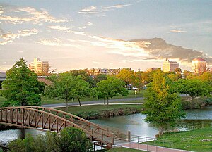
|
San Angelo | Tom Green | 99,262 |
| 7 | 95 | 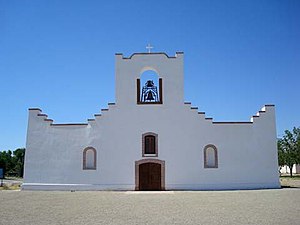
|
Socorro | El Paso | 38,238 |
| 8 | 133 | 
|
Horizon City | El Paso | 24,168 |
| 9 | 140 | 
|
Big Spring | Howard | 22,373 |
| 10 | 155 | 
|
Plainview | Hale | 19,420 |
Smaller West Texas cities and towns include Alpine, Andrews, Anthony, Brownfield, Canutillo, Coyanosa, Crane, Fabens, Fort Davis, Fort Stockton, Hale Center, Horizon City, Iraan, Kermit, Lamesa, Levelland, Littlefield, Marathon, Marfa, McCamey, Mertzon, Monahans, Ozona, Pecos, Post, Rankin, San Elizario, Seminole, Slaton, Snyder, Sweetwater, and Van Horn.
Economy[edit]
Major industries include livestock, petroleum and natural gas production, textiles such as cotton, grain, and because of very large military installations such as Fort Bliss, the defense industry. West Texas has become notable for its numerous wind turbines producing clean and alternative electricity.
As of 2018, the West Texan economy was in a prosperous economic period, which has been described as the "West Texas oil boom".[8][9]
-
Pumpjacks, like this one south of Midland, are a common sight in West Texas oil fields.
-
Irrigated agriculture in West Texas
-
The Brazos Wind Farm near Fluvanna is one of many wind farms in West Texas.
-
Fort Bliss is the number one employer in the El Paso region


Sports[edit]
While there are no major league teams in the West Texas region, sports fans are faithful to their local high school and college teams. NCAA Division I college teams include the Texas Tech Red Raiders, and the UTEP Miners. NCAA Division II teams include the West Texas A&M Buffaloes, the Texas–Permian Basin Falcons, and the Lubbock Christian Chaparrals and Lady Chaps.
El Paso hosts the El Paso Chihuahuas, a AAA baseball team, and the El Paso Locomotive FC which plays in the USL Championship, the second tier of the American soccer pyramid. The Midland RockHounds and Amarillo Sod Poodles represent the region in double-A baseball. Junior hockey is also present in the region, with the Odessa Jackalopes of the Tier II North American Hockey League.
Politics[edit]

Except for the Trans-Pecos region, West Texas has become well known as a stronghold for conservative politics. Some of the most heavily Republican counties in the United States are in the region. Former U.S. President George W. Bush spent most of his childhood in West Texas.
The region is part of the Permian Basin, the highest producing oil field in the United States.[10] This likely inclines the region to support the Republican Party over the Democratic Party, as the latter supports environmentalism and action on climate change.[11][12]
Several counties in the Midland-Odessa area were some of the first parts of Texas to abandon the state's "Solid South" Democratic roots; two counties[a] have not supported a Democrat for president since 1948. The Rolling Plains to the east remained Democratic substantially longer: although Walter Mondale's 1984 campaign lost Texas by 27.50%, he won three counties in this region.[b] Since 2000, this region swung very rapidly toward the Republican Party due to its population's intransigent opposition to the liberal social policies of the Democratic Party,[13] and by 2016, it had nearly the same Cook PVI as the Panhandle.
West of the Pecos in popular culture[edit]
West Texas.
"West of the Pecos" has become a metaphor for the universe of Westerns. "Fastest draw west of the Pecos" and similar superlatives are a cliche, and the title character of Chisum observed "There’s no law west of Dodge, and no God west of the Pecos”.
Cormac McCarthy's novel No Country for Old Men and its subsequent film adaptation take place in West Texas, and much of the movie was filmed there.
See also[edit]
- List of geographical regions in Texas
- Beach Mountains
- Big Bend National Park
- Chalk Mountains
- Chamizal National Memorial
- Davis Mountains
- Franklin Mountains State Park
- Guadalupe Mountains National Park
- Hueco Tanks State Historic Site
- Llano Estacado
- McKittrick Canyon
- Mount Blanco
- West Texas Intermediate
- Wind power in Texas
- Wyler Aerial Tramway
- Ysleta del Sur Pueblo
References[edit]
- ^ Cochran, M., Lumpkin, J. and Heflin, R. 1999. West Texas: a portrait of its people and their raw and wondrous land. Lubbock: Texas Tech University Press, 176 pp.
- ^ Webb, W.P. 1935. The Texas Rangers: a century of frontier defense. New York: Houghton Mifflin Co., 583 pp.
- ^ Greene, A.C. 1998. Sketches from the five states of Texas. College Station: Texas A&M University Press, 176 pp.
- ^ Hill, R.T. 1887. The topography and geology of the Cross Timbers and surrounding regions in Northern Texas. The American Journal of Science, 3rd Series, 33:291–303.
- ^ Bubenik, Travis (2018-04-15). "Texas Could Look Increasingly Like West Texas, Climate Study Says". Houston Public Media. Retrieved 2020-10-20.
- ^ "The Regions of Texas". Texas Counties.net. Retrieved 13 October 2014.
- ^ "Annual Estimates of the Resident Population for Incorporated Places in Texas: April 1, 2020 to July 1, 2023 (SUB-IP-EST2023-POP-48)" (XLSX). United States Census Bureau, Population Division. May 16, 2024. Retrieved May 23, 2024.
- ^ Clifford, Krauss (March 28, 2018). "$9.5 Billion Purchase by Concho Is Latest Sign of West Texas Oil Boom". The New York Times. Retrieved May 15, 2018.
- ^ Saphir, Ann (May 1, 2018). "Boom in West Texas oil patch lifts wages, prices". Reuters. Retrieved May 15, 2018.
- ^ US Department of Energy (November 2018). "Permian Basin Geology Review" (PDF). Archived (PDF) from the original on February 26, 2021.
- ^ Tabuchi, Hiroko (October 16, 2019). "Despite Their Promises, Giant Energy Companies Burn Away Vast Amounts of Natural Gas". The New York Times. ISSN 0362-4331. Archived from the original on June 5, 2021. Retrieved October 17, 2019.
- ^ Storrow, Benjamin (5 May 2020). "Methane Leaks Erase Some of the Climate Benefits of Natural Gas". Scientific American. Archived from the original on 27 April 2022.
- ^ Cohn, Nate; 'Demographic Shift: Southern Whites' Loyalty to G.O.P. Nearing That of Blacks to Democrats', New York Times, April 24, 2014
Notes[edit]
- ^ West Texas counties voting Republican at every election since 1952 comprise Ector County, Midland County.
- ^ West Texas Plains "Bible Belt" counties voting for Mondale in 1984 were Dickens County, Fisher County, and Stonewall County.