Special route: Difference between revisions
PAhighways33 (talk | contribs) |
|||
| (13 intermediate revisions by 10 users not shown) | |||
| Line 1: | Line 1: | ||
{{Short description|Type of United States road}} |
|||
{{Redirect|Auxiliary route|auxiliary Interstate Highways|List of auxiliary Interstate Highways}} |
{{Redirect|Auxiliary route|auxiliary Interstate Highways|List of auxiliary Interstate Highways}} |
||
{{Use mdy dates|date=July 2013}} |
{{Use mdy dates|date=July 2013}} |
||
| Line 7: | Line 8: | ||
==Nomenclature== |
==Nomenclature== |
||
[[File:Truck Business-US 17-Elizabeth City,NC.JPG|thumb|right|Truck Business US 17 ends at its parent in [[Elizabeth City, North Carolina]]]] |
[[File:Truck Business-US 17-Elizabeth City,NC.JPG|thumb|right|Truck Business US 17 ends at its parent in [[Elizabeth City, North Carolina]]]] |
||
In the field, the special route is typically distinguished from the parent route with the use of auxiliary words or suffix letters placed on the route shield or on an adjacent sign, known as a "banner" or "plate" or according to the ''[[Manual on Uniform Traffic Control Devices]]'', a "route sign auxiliary sign".<ref>{{cite book |author= Staff |year= 2009 |url= http://mutcd.fhwa.dot.gov/pdfs/2009/part2d.pdf |title= Chapter 2D. Guide Signs: Conventional Roads |work= [[Manual on Uniform Traffic Control Devices]] |edition= 2009 |location= Washington, DC |publisher= [[Federal Highway Administration]] |pages= 143–4 |oclc= 786163525 | |
In the field, the special route is typically distinguished from the parent route with the use of auxiliary words or suffix letters placed on the route shield or on an adjacent sign, known as a "banner" or "plate" or according to the ''[[Manual on Uniform Traffic Control Devices]]'', a "route sign auxiliary sign".<ref>{{cite book |author= Staff |year= 2009 |url= http://mutcd.fhwa.dot.gov/pdfs/2009/part2d.pdf |title= Chapter 2D. Guide Signs: Conventional Roads |work= [[Manual on Uniform Traffic Control Devices]] |edition= 2009 |location= Washington, DC |publisher= [[Federal Highway Administration]] |pages= 143–4 |oclc= 786163525 |access-date=October 1, 2014}}</ref> A common [[roadfan]] synonym for special route is "'''bannered highway'''" or "'''bannered route'''", terms coined from the presence of these companion signs.{{citation needed|date=February 2018}}<ref name=WesKinsler>{{cite web |first= Wes |last= Kinsler |date= April 15, 2004 |url= http://www.wkinsler.com/highways/oklahoma.html |title= Oklahoma's U.S. Highway History |access-date= October 1, 2014}}{{self-published source|date=October 2014}}</ref><ref name=Hawaii>{{cite web |first= Oscar |last= Voss |date= December 2010 |url= http://www.hawaiihighways.com/FAQs-page3.htm |work= Hawaii Highways |title= FAQ Page 3 |access-date=October 1, 2014}}{{self-published source|date=October 2014}}</ref> The term is not all-encompassing however, as not all special routes have these sign plates. |
||
The [[American Association of State Highway and Transportation Officials]] (AASHTO) sets the nationwide precedent for special routes, particularly for [[U.S. Numbered Highways]]. As of 2009, the [[standards organization]] only advocates four types of special routes: business, bypass, alternate, and temporary. AASHTO suggests that transportation authorities of the United States remove other types of special routes and/or replace such obsolete designations with another type of route. |
The [[American Association of State Highway and Transportation Officials]] (AASHTO) sets the nationwide precedent for special routes, particularly for [[U.S. Numbered Highways]]. As of 2009, the [[standards organization]] only advocates four types of special routes: business, bypass, alternate, and temporary. AASHTO suggests that transportation authorities of the United States remove other types of special routes and/or replace such obsolete designations with another type of route. |
||
| Line 13: | Line 14: | ||
Some old alignments of routes may also be informally known as special routes (despite some that do not intersect the parent route). These older alignments may be given street names like "Old U.S. Highway 52", or in some rare cases, be signed with route shields attached to "Old" or "Historic" sign plates (such as [[decommissioned highway|decommissioned sections]] of former [[U.S. Route 66]] that are still driveable). |
Some old alignments of routes may also be informally known as special routes (despite some that do not intersect the parent route). These older alignments may be given street names like "Old U.S. Highway 52", or in some rare cases, be signed with route shields attached to "Old" or "Historic" sign plates (such as [[decommissioned highway|decommissioned sections]] of former [[U.S. Route 66]] that are still driveable). |
||
In the case of U.S. [[State highway|state route]] systems, special routes are generally restricted to primary state routes, not secondary state routes, though [[Missouri]] has three [[Missouri supplemental route|supplemental routes]] with short spur routes, and the [[500-series county route]]s in [[New Jersey]] have alternate, bypass, spur, and truck routes.<ref name=SLD>{{cite web |author= Staff |url= http://www.state.nj.us/transportation/refdata/sldiag/500%20Routes.pdf |title= 500 Series Routes Straight Line Diagrams |publisher= [[New Jersey Department of Transportation]] | |
In the case of U.S. [[State highway|state route]] systems, special routes are generally restricted to primary state routes, not secondary state routes, though [[Missouri]] has three [[Missouri supplemental route|supplemental routes]] with short spur routes, and the [[500-series county route]]s in [[New Jersey]] have alternate, bypass, spur, and truck routes.<ref name=SLD>{{cite web |author= Staff |url= http://www.state.nj.us/transportation/refdata/sldiag/500%20Routes.pdf |title= 500 Series Routes Straight Line Diagrams |publisher= [[New Jersey Department of Transportation]] |access-date= August 29, 2010}}</ref> |
||
A few highways have two special route designations. Some of these doubly designated special routes are: |
A few highways have two special route designations. Some of these doubly designated special routes are: |
||
| Line 36: | Line 37: | ||
The [[American Association of State Highway and Transportation Officials]] (AASHTO) defines a business route for U.S. highways as <blockquote> |
The [[American Association of State Highway and Transportation Officials]] (AASHTO) defines a business route for U.S. highways as <blockquote> |
||
...a route principally within the corporate limits of a city which provides the traveling public an opportunity to travel through that city, passing through the business part of the city; while the regular number is used to obviate passing through the congested part of the city. This "Business Route" connects with the regular numbered route at the opposite side of the city limits.<ref name="Manual">{{cite web |first= Richard C. |last= Moeur |date= September 15, 2010 |url= http://www.trafficsign.us/route.html |title= Special Route Definitions |work= Manual of Traffic Signs | |
...a route principally within the corporate limits of a city which provides the traveling public an opportunity to travel through that city, passing through the business part of the city; while the regular number is used to obviate passing through the congested part of the city. This "Business Route" connects with the regular numbered route at the opposite side of the city limits.<ref name="Manual">{{cite web |first= Richard C. |last= Moeur |date= September 15, 2010 |url= http://www.trafficsign.us/route.html |title= Special Route Definitions |work= Manual of Traffic Signs |access-date=October 1, 2014}}{{self-published source|date= October 2014}}</ref> |
||
</blockquote> |
</blockquote> |
||
| Line 47: | Line 48: | ||
{{See also|List of business routes of the Interstate Highway System}} |
{{See also|List of business routes of the Interstate Highway System}} |
||
[[File:Business Loop 85.svg|70px|thumb|right|Business Loop Interstate 85]] |
[[File:Business Loop 85.svg|70px|thumb|right|Business Loop Interstate 85]] |
||
AASHTO defines a category of special routes separate from primary and auxiliary Interstate designations known as |
AASHTO defines a category of special routes separate from primary and auxiliary Interstate designations known as Interstate Business routes. These routes do not have to comply to Interstate construction standards, but are routes that may be identified and approved by the association. The same route marking policy applies to both U.S. Numbered Highways and Interstate highways; however, [[business route]] designations are sometimes used for Interstate highways.<ref name="aashto_ho1">{{cite web |url= http://sp.route.transportation.org/Documents/HO1_Policy_Establ_Develop_USRN.pdf |title= Establishment and Development of United States Numbered Highways |date= January 2000 |access-date= January 23, 2008 |author= Staff |publisher= [[American Association of State Highway and Transportation Officials]] }}</ref> |
||
Known as [[Business Loop]]s and [[Business Spur]]s, these routes that principally travel through the corporate limits of a city, passing through the [[central business district]] of the city. Business routes are used when the regular route is directed around the city.<ref name="aashto_ho1" /> They sport green Interstate shields, as opposed to the normal red and blue, with the word "Business" replacing the normal "Interstate" word on the upper portion of the shield. |
Known as [[Business Loop]]s and [[Business Spur]]s, these routes that principally travel through the corporate limits of a city, passing through the [[central business district]] of the city. Business routes are used when the regular route is directed around the city.<ref name="aashto_ho1" /> They sport green Interstate shields, as opposed to the normal red and blue, with the word "Business" replacing the normal "Interstate" word on the upper portion of the shield. |
||
| Line 53: | Line 54: | ||
====Truck routes==== |
====Truck routes==== |
||
[[File:US 1-9 Truck.svg|70px|right|thumb|[[U.S. Route 1/9 Truck]] in [[New Jersey]]]] |
[[File:US 1-9 Truck.svg|70px|right|thumb|[[U.S. Route 1/9 Truck]] in [[New Jersey]]]] |
||
Truck routes were initially known as Bypass routes, and were loops created as a means to divert through truck traffic away from population centers, but the designation was changed to "bypass" in 1959-1960 by [[American Association of State Highway and Transportation Officials|AASHTO]]. Today, Truck routes exist as alternatives for the mainline routes that are ill-suited for large truck travel<ref name="DC special routes">{{cite web |url= http://fleetowner.com/news/fleet_dc_considering_special/ |work= Fleet Owner |title= DC Considering Special Routes for Trucks |date= January 5, 2004 | |
Truck routes were initially known as Bypass routes, and were loops created as a means to divert through truck traffic away from population centers, but the designation was changed to "bypass" in 1959-1960 by [[American Association of State Highway and Transportation Officials|AASHTO]]. Today, Truck routes exist as alternatives for the mainline routes that are ill-suited for large truck travel<ref name="DC special routes">{{cite web |url= http://fleetowner.com/news/fleet_dc_considering_special/ |work= Fleet Owner |title= DC Considering Special Routes for Trucks |date= January 5, 2004 |access-date=October 1, 2014}}</ref> with obstacles (such as low clearance bridges, sharp turns, or steep [[grade (slope)|grades]]) or with conditions that could create dangerous situations to smaller vehicles. An example of such a route is [[U.S. Route 1/9 Truck]] in [[New Jersey]], which bypasses the segment of [[U.S. Route 1/9]] that uses the [[Pulaski Skyway]], on which trucks are banned.<ref name=njdot>{{cite web |author= Staff |url= http://www.state.nj.us/transportation/refdata/traffic_orders/access/rt1_9.shtm |title= Traffic Regulations: Route 1 and 9, the Pulaski Skyway |publisher= New Jersey Department of Transportation |access-date= August 6, 2009}}</ref> |
||
===Alternate Truck Routes=== |
===Alternate Truck Routes=== |
||
There are alternate truck routes in several counties in [[Pennsylvania]]. They bypass weight-restricted bridges over creeks and rivers. They are mainly routed on major highways and freeways and other roads they intersect to bypass that specific bridge. An example of an alternate truck route is [[Pennsylvania Route 82#PA 82 Alternate Truck|Pennsylvania Route 82 Alternate Truck]] which bypasses a weight-restricted bridge over East Branch of Red Clay Creek. |
There are alternate truck routes in several counties in southeastern [[Pennsylvania]]. They bypass weight-restricted bridges over creeks and rivers. They are mainly routed on major highways and freeways and other roads they intersect to bypass that specific bridge. An example of an alternate truck route is [[Pennsylvania Route 82#PA 82 Alternate Truck|Pennsylvania Route 82 Alternate Truck]] which bypasses a weight-restricted bridge over East Branch of Red Clay Creek. Most of the alternate truck routes were signed in 2013, though some were signed as recently as 2023. |
||
===Alternate and Optional routes=== |
===Alternate and Optional routes=== |
||
{{Main|Alternate route}} |
{{Main|Alternate route}} |
||
[[File:2017-06-12 14 22 00 View east along U.S. Route 58 Alternate (Trail of the Lonesome Pine) between Ed Ward Drive and Steve Reasor Drive in Deep Springs, Lee County, Virginia.jpg|thumb|right|[[U.S. Route 58 Alternate]] serves as an alternate alignment to [[U.S. Route 58]] in the western part of [[Virginia]]]] |
|||
Alternate routes are loops that provide alternative alignment for a parent route. They are usually signed with an "{{smallcaps|alternate}}" or "{{smallcaps|alt}}" auxiliary or an "A" suffix. They generally traverse through a different settlements or different city neighborhoods than the parent route, but roughly remain parallel to the parent. Unlike business routes and bypasses, their relationship to population centers varies from case to case. Alternates also can be quite longer than most other special routes with some spanning over 50 miles (e.g. [[US 1A]] in [[Maine]] and [[US 74A]] in [[North Carolina]]). |
Alternate routes are loops that provide alternative alignment for a parent route. They are usually signed with an "{{smallcaps|alternate}}" or "{{smallcaps|alt}}" auxiliary or an "A" suffix. They generally traverse through a different settlements or different city neighborhoods than the parent route, but roughly remain parallel to the parent. Unlike business routes and bypasses, their relationship to population centers varies from case to case. Alternates also can be quite longer than most other special routes with some spanning over 50 miles (e.g. [[US 1A]] in [[Maine]] and [[US 74A]] in [[North Carolina]]). |
||
| Line 87: | Line 89: | ||
===Loop routes=== |
===Loop routes=== |
||
{{Main articles|Ring road}} |
|||
[[File:Georgia 10 Loop.svg|70px|thumb|[[Georgia State Route 10 Loop (Athens)|Georgia Loop 10]] is a loop route.]] |
[[File:Georgia 10 Loop.svg|70px|thumb|[[Georgia State Route 10 Loop (Athens)|Georgia Loop 10]] is a loop route.]] |
||
Loop routes, in terms of special routes, are loops that form a complete radial around an area, having at least one intersection with the parent route. Because of their circumferential nature, [[inner/outer directions]] have been used to sign such routes, as opposed to [[cardinal direction]]s, though this convention is not universally followed (Arizona Loops [[Arizona State Route 101|101]], [[Arizona State Route 202|202]], and [[Arizona State Route 303|303]] in the [[Phoenix metropolitan area]] do not follow such convention, and are signed with cardinal directions based on their local orientation). [[Georgia State Route 10 Loop (Athens)|Georgia State Route 10 Loop]], which is the perimeter highway around [[Athens, Georgia]], and the former [[Georgia State Route 120 Loop]], which encircled a section of [[Marietta, Georgia]], are two examples. Loop routes are common throughout Texas; see [[List of state highway loops in Texas]]. |
Loop routes, in terms of special routes, are loops that form a complete radial around an area, having at least one intersection with the parent route. Because of their circumferential nature, [[inner/outer directions]] have been used to sign such routes, as opposed to [[cardinal direction]]s, though this convention is not universally followed (Arizona Loops [[Arizona State Route 101|101]], [[Arizona State Route 202|202]], and [[Arizona State Route 303|303]] in the [[Phoenix metropolitan area]] do not follow such convention, and are signed with cardinal directions based on their local orientation). [[Georgia State Route 10 Loop (Athens)|Georgia State Route 10 Loop]], which is the perimeter highway around [[Athens, Georgia]], and the former [[Georgia State Route 120 Loop]], which encircled a section of [[Marietta, Georgia]], are two examples. Loop routes are common throughout Texas; see [[List of state highway loops in Texas]]. |
||
===Temporary routes=== |
===Temporary routes=== |
||
[[File:New Jersey State Route 41 |
[[File:2018-10-02 16 18 25 View north along New Jersey State Route 41 and Camden County Route 573 (Kings Highway) at Camden County Route 641 (West End Avenue) in Haddonfield, Camden County, New Jersey.jpg|right|thumb|[[New Jersey Route 41|Route 41]] Temporary signage in [[Haddonfield, New Jersey]]]] |
||
Temporary routes complete a gap between two segments of a parent route that exists because the parent route through the area has not been fully constructed. They serve as a long-term detour until the parent route's planned path is completed, at which point the Temporary designation is either removed or replaced by another designation such as Alternate or Business. Temporary routes generally traverse along roads of a lower standard than the planned mainline. An example is [[U.S. Route 191 in Arizona|US 191]] through a copper mine north of [[Clifton, Arizona]]. |
Temporary routes complete a gap between two segments of a parent route that exists because the parent route through the area has not been fully constructed. They serve as a long-term detour until the parent route's planned path is completed, at which point the Temporary designation is either removed or replaced by another designation such as Alternate or Business. Temporary routes generally traverse along roads of a lower standard than the planned mainline. An example is [[U.S. Route 191 in Arizona|US 191]] through a copper mine north of [[Clifton, Arizona]]. |
||
| Line 105: | Line 108: | ||
[[File:Emergency plate.svg|70px|thumb|left|Emergency plate]] |
[[File:Emergency plate.svg|70px|thumb|left|Emergency plate]] |
||
[[File:Clmei94.jpg|thumb|upright|Emergency I-94 shields in [[Coloma, Michigan]]]] |
[[File:Clmei94.jpg|thumb|upright|Emergency I-94 shields in [[Coloma, Michigan]]]] |
||
A rare type of special route, known as the Emergency Detour route, is signed with an auxiliary "Emergency" banner that is colored orange, indicating a temporary traffic control sign. The purpose of these routes is to offer an alternative in |
A rare type of special route, known as the Emergency Detour route, is signed with an auxiliary "Emergency" banner that is colored orange, indicating a temporary traffic control sign. The purpose of these routes is to offer an alternative in case the parent route is impassable, due to either a [[traffic jam]]s, [[traffic collision]], or road closure (for a variety of reasons). [[Emergency U.S. Route 31]], which offers an alternative crossing of the [[Grand River (Michigan)|Grand River]] in case the [[bascule bridge]] in [[Grand Haven, Michigan|Grand Haven]], [[Michigan]] is unavailable for motorists,<ref name="Bascule">{{cite press release |first= Benjamin |last= Kohrman |date= August 19, 2005 |url= http://www.michigan.gov/mdot/0,1607,7-151-9620_11057-124559--,00.html |title= MDOT Establishes US 31/Bascule Bridge Emergency Detour Routes |publisher= [[Michigan Department of Transportation]] |archive-url= https://web.archive.org/web/20120213221711/http://www.michigan.gov/mdot/0,1607,7-151-9620_11057-124559--,00.html |archive-date= February 13, 2012}}</ref> is one such route. According to the [[Michigan Department of Transportation]], "This route would only be used in emergency situations and worst-case scenarios impacting the entire bridge structure."<ref name="Bascule" /> Emergency [[Interstate 94]] follows Interstate 94 throughout much of southern Michigan.<ref>{{cite web |first= Marc |last= Fannin |date= June 27, 2005 |url= http://www.roadfan.com/michrdph.html#ei94 |title= Michiana Road Photos: Emergency Interstate 94 |work= Roadfan.com}}{{self-published source|date=October 2014}}</ref> |
||
[[Ontario]], [[Canada]] is one jurisdiction outside the United States with a very prevalent system of these roads. |
[[Ontario]], [[Canada]] is one jurisdiction outside the United States with a very prevalent system of these roads. |
||
| Line 119: | Line 122: | ||
==History== |
==History== |
||
Originally in the United States, the terms used for special routes were "City", "Truck", and "Optional". In |
Originally in the United States, the terms used for special routes were "City", "Truck", and "Optional". In 1959–1960, the terms were changed to "Business", "Bypass", and "Alternate", respectively; however, the "Truck" banner is still used today on many routes, especially those where trucks are prohibited on the mainline (for example, [[U.S. Route 1/9 Truck]] in [[Jersey City, New Jersey]], which routes trucks around the Pulaski Skyway, which bans them). The [[American Association of State Highway and Transportation Officials]] (AASHTO) has called for the removal of "alternate" routes, though many still exist. |
||
==See also== |
==See also== |
||
Latest revision as of 03:52, 25 June 2023
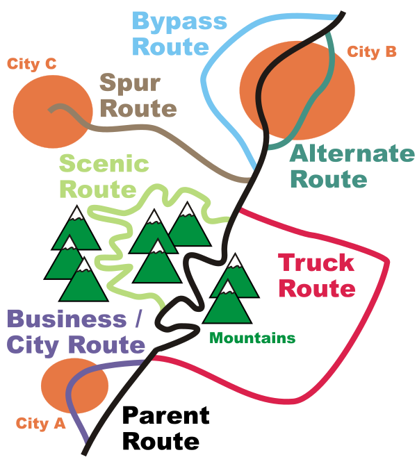
In road transportation in the United States, a special route is a road in a numbered highway system that diverts a specific segment of related traffic away from another road. They are featured in many highway systems; most are found in the Interstate Highway System, U.S. highway system, and several state highway systems. Each type of special route possesses generally defined characteristics and has a defined relationship with its parent route. Typically, special routes share a route number with a dominant route, often referred as the "parent" or "mainline", and are given either a descriptor which may be used either before or after the route name, such as Alternate or Business, or a letter suffix that is attached to the route number. For example, an alternate route of U.S. Route 1 may be called "Alternate U.S. Route 1", "U.S. Route 1 Alternate", or "U.S. Route 1A". Occasionally, a special route will have both a descriptor and a suffix, such as U.S. Route 1A Business.
Nomenclature
[edit]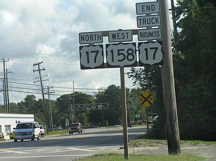
In the field, the special route is typically distinguished from the parent route with the use of auxiliary words or suffix letters placed on the route shield or on an adjacent sign, known as a "banner" or "plate" or according to the Manual on Uniform Traffic Control Devices, a "route sign auxiliary sign".[1] A common roadfan synonym for special route is "bannered highway" or "bannered route", terms coined from the presence of these companion signs.[citation needed][2][3] The term is not all-encompassing however, as not all special routes have these sign plates.
The American Association of State Highway and Transportation Officials (AASHTO) sets the nationwide precedent for special routes, particularly for U.S. Numbered Highways. As of 2009, the standards organization only advocates four types of special routes: business, bypass, alternate, and temporary. AASHTO suggests that transportation authorities of the United States remove other types of special routes and/or replace such obsolete designations with another type of route.
Some old alignments of routes may also be informally known as special routes (despite some that do not intersect the parent route). These older alignments may be given street names like "Old U.S. Highway 52", or in some rare cases, be signed with route shields attached to "Old" or "Historic" sign plates (such as decommissioned sections of former U.S. Route 66 that are still driveable).
In the case of U.S. state route systems, special routes are generally restricted to primary state routes, not secondary state routes, though Missouri has three supplemental routes with short spur routes, and the 500-series county routes in New Jersey have alternate, bypass, spur, and truck routes.[4]
A few highways have two special route designations. Some of these doubly designated special routes are:
- Alternate Business US 66 in Springfield, Missouri
- Business US 1A in downtown Bangor, Maine
- Truck Business US 17 in Elizabeth City, North Carolina
- Business US 77 Alternate in Yoakum, Texas
- U.S. Route 202 Alternate Truck in Montgomery County, Pennsylvania (Many Pennsylvania highways use this "Alternate Truck" pattern)
- Business Alternate US 58 in Norton, Virginia and Big Stone Gap, Virginia.
There is also an example of a route with three special route designations. U.S. Route 30 Business Alternate Truck provides an alternate truck bypass of U.S. Route 30 Business in Downingtown, Pennsylvania.
Special route types and respective behavior
[edit]
Routes with special designations in the U.S. have typical behavior that distinguishes them from other routes. There are, however, many exceptions to the common behavior, depending on the situation.
Business, City, and Bypass routes
[edit]Business routes (also known as city routes) can be loops or spurs and generally traverse through or near population centers (usually towns and small cities). They are usually signed with "business" or "bus" auxiliaries or a "B" suffix. Most business routes are the former alignments of their parent. Bypass routes (rarely known as "Relief routes") typically go around population centers and are newer and faster than their mainline and/or business route counterparts.
In some cases, due to urban sprawl over time, land around bypasses can become developed, expanding the population center outward and creating a misnomer with the term "bypass" (e.g. U.S. Highway 17 Bypass in Myrtle Beach). Approaching a population center, it is common for the parent route to split between a business route and a bypass route and rejoin to form the parent on the other side.
The American Association of State Highway and Transportation Officials (AASHTO) defines a business route for U.S. highways as
...a route principally within the corporate limits of a city which provides the traveling public an opportunity to travel through that city, passing through the business part of the city; while the regular number is used to obviate passing through the congested part of the city. This "Business Route" connects with the regular numbered route at the opposite side of the city limits.[5]
AASHTO defines bypass or relief routes for U.S. highways as:
...a route which is established for the purpose of designating a route which entirely by-passes a city or congested area and joins in with the regular numbered route beyond the city or congested area.[5]
Business Interstates
[edit]
AASHTO defines a category of special routes separate from primary and auxiliary Interstate designations known as Interstate Business routes. These routes do not have to comply to Interstate construction standards, but are routes that may be identified and approved by the association. The same route marking policy applies to both U.S. Numbered Highways and Interstate highways; however, business route designations are sometimes used for Interstate highways.[6]
Known as Business Loops and Business Spurs, these routes that principally travel through the corporate limits of a city, passing through the central business district of the city. Business routes are used when the regular route is directed around the city.[6] They sport green Interstate shields, as opposed to the normal red and blue, with the word "Business" replacing the normal "Interstate" word on the upper portion of the shield.
Truck routes
[edit]
Truck routes were initially known as Bypass routes, and were loops created as a means to divert through truck traffic away from population centers, but the designation was changed to "bypass" in 1959-1960 by AASHTO. Today, Truck routes exist as alternatives for the mainline routes that are ill-suited for large truck travel[7] with obstacles (such as low clearance bridges, sharp turns, or steep grades) or with conditions that could create dangerous situations to smaller vehicles. An example of such a route is U.S. Route 1/9 Truck in New Jersey, which bypasses the segment of U.S. Route 1/9 that uses the Pulaski Skyway, on which trucks are banned.[8]
Alternate Truck Routes
[edit]There are alternate truck routes in several counties in southeastern Pennsylvania. They bypass weight-restricted bridges over creeks and rivers. They are mainly routed on major highways and freeways and other roads they intersect to bypass that specific bridge. An example of an alternate truck route is Pennsylvania Route 82 Alternate Truck which bypasses a weight-restricted bridge over East Branch of Red Clay Creek. Most of the alternate truck routes were signed in 2013, though some were signed as recently as 2023.
Alternate and Optional routes
[edit]
Alternate routes are loops that provide alternative alignment for a parent route. They are usually signed with an "alternate" or "alt" auxiliary or an "A" suffix. They generally traverse through a different settlements or different city neighborhoods than the parent route, but roughly remain parallel to the parent. Unlike business routes and bypasses, their relationship to population centers varies from case to case. Alternates also can be quite longer than most other special routes with some spanning over 50 miles (e.g. US 1A in Maine and US 74A in North Carolina).
Prior to 1960 there were "optional" routes in the United States that were synonymous with alternate routes. As a means of providing uniformity, the "Optional" term was phased out in the 1960s.
AASHTO defines and specifies that alternate routes should have the following behavior:
An "Alternate Route" shall be considered a route which starts at a point where it branches off from the main numbered route, may pass through certain cities and towns, and then connect back with the regular route some miles distant. Since it is the purpose of the U.S. numbered system to mark the best and shortest route available, an alternate route should be designated only where both routes are needed to accommodate the traffic demand, and when the alternate route has substantially the same geometric and structural design standards of the main marked routing. It is recommended that in case an alternate route is marked, that the shorter and better constructed route be given the regular number and the other section designated as the "Alternate Route". It is further recommended that the Highway Department erect signs at the junction points of the regular and alternate routes giving the distance between the cities or points concerned... In no instance should an alternate routing be used for the purpose of keeping an obsolete section on the U.S. numbered system after a new routing has been constructed and available to traffic.[5]
Spur and Connector routes
[edit]
Spur routes split away from the parent route without returning. They usually end in a settlement or area not served by the parent. Connector routes are spurs that connect the parent route with a nearby prominent route, usually an Interstate highway (e.g. Connector M-44 [Conn. M-44] connects M-44 to I-96). Both Spurs and Connectors are generally very short in length, not spanning more than ten miles (16 km).
Scenic routes
[edit]
Scenic routes, in terms of special routes, are loops of a parent route that traverse through an area of natural or historical significance. Only one route in the country remains with the official Scenic designation: US 40 Scenic.
Toll routes
[edit]
Toll routes, in terms of special routes, are loops that are faster than the parent route, but are tolled. The other usage with the promulgation of the 2009 MUTCD is to use a new yellow toll plate above the marker along tolled segments of highways.[9]
Loop routes
[edit]
Loop routes, in terms of special routes, are loops that form a complete radial around an area, having at least one intersection with the parent route. Because of their circumferential nature, inner/outer directions have been used to sign such routes, as opposed to cardinal directions, though this convention is not universally followed (Arizona Loops 101, 202, and 303 in the Phoenix metropolitan area do not follow such convention, and are signed with cardinal directions based on their local orientation). Georgia State Route 10 Loop, which is the perimeter highway around Athens, Georgia, and the former Georgia State Route 120 Loop, which encircled a section of Marietta, Georgia, are two examples. Loop routes are common throughout Texas; see List of state highway loops in Texas.
Temporary routes
[edit]
Temporary routes complete a gap between two segments of a parent route that exists because the parent route through the area has not been fully constructed. They serve as a long-term detour until the parent route's planned path is completed, at which point the Temporary designation is either removed or replaced by another designation such as Alternate or Business. Temporary routes generally traverse along roads of a lower standard than the planned mainline. An example is US 191 through a copper mine north of Clifton, Arizona.
AASHTO defines and specifies that temporary routes should have the following behavior:
In the erection of signs for numbering routes, it is necessary in some cases to carry a number temporarily over a road that ultimately will not be the permanent location of that number. Great care should be taken by the State Highway Departments in seeing that when numbers of this character are permitted, that a standard strip carrying the words "Temporary" shall be placed on the staff above the number. This will obviate much hard feeling when it is necessary to change a number to the permanently established route. [5]
Emergency detour routes
[edit]

A rare type of special route, known as the Emergency Detour route, is signed with an auxiliary "Emergency" banner that is colored orange, indicating a temporary traffic control sign. The purpose of these routes is to offer an alternative in case the parent route is impassable, due to either a traffic jams, traffic collision, or road closure (for a variety of reasons). Emergency U.S. Route 31, which offers an alternative crossing of the Grand River in case the bascule bridge in Grand Haven, Michigan is unavailable for motorists,[10] is one such route. According to the Michigan Department of Transportation, "This route would only be used in emergency situations and worst-case scenarios impacting the entire bridge structure."[10] Emergency Interstate 94 follows Interstate 94 throughout much of southern Michigan.[11]
Ontario, Canada is one jurisdiction outside the United States with a very prevalent system of these roads.
Other governments have a variation on this concept, though not always a "special route":
Divided routes
[edit]
Some U.S. Routes are given directional suffixes to indicate a split of the main route — for instance, U.S. Route 25 splits into U.S. Route 25E (east) and U.S. Route 25W (west) between Newport, Tennessee and North Corbin, Kentucky, and U.S. Route 9W is an alternate of U.S. Route 9 between Fort Lee, New Jersey and Albany, New York. These splits were in the system of United States Numbered Highways from the beginning, and were used when two roughly equivalent routes existed.
They are usually loops, but some have been spurs, though since they use directional letter suffixes, they are not generally considered "bannered routes". The American Association of State Highway and Transportation Officials no longer assigns these numbers, and in theory current ones are to be eliminated "as rapidly as the State Highway Department and the Standing Committee on Highways can reach agreement". This policy was adopted by 1996; however, many of these routes still exist, mostly in Tennessee.
History
[edit]Originally in the United States, the terms used for special routes were "City", "Truck", and "Optional". In 1959–1960, the terms were changed to "Business", "Bypass", and "Alternate", respectively; however, the "Truck" banner is still used today on many routes, especially those where trucks are prohibited on the mainline (for example, U.S. Route 1/9 Truck in Jersey City, New Jersey, which routes trucks around the Pulaski Skyway, which bans them). The American Association of State Highway and Transportation Officials (AASHTO) has called for the removal of "alternate" routes, though many still exist.
See also
[edit]- List of auxiliary Interstate Highways
- List of special routes of the United States Numbered Highway System
- List of business routes of the Interstate Highway System
References
[edit]- ^ Staff (2009). Chapter 2D. Guide Signs: Conventional Roads (PDF) (2009 ed.). Washington, DC: Federal Highway Administration. pp. 143–4. OCLC 786163525. Retrieved October 1, 2014.
{{cite book}}:|work=ignored (help) - ^ Kinsler, Wes (April 15, 2004). "Oklahoma's U.S. Highway History". Retrieved October 1, 2014.[self-published source]
- ^ Voss, Oscar (December 2010). "FAQ Page 3". Hawaii Highways. Retrieved October 1, 2014.[self-published source]
- ^ Staff. "500 Series Routes Straight Line Diagrams" (PDF). New Jersey Department of Transportation. Retrieved August 29, 2010.
- ^ a b c d Moeur, Richard C. (September 15, 2010). "Special Route Definitions". Manual of Traffic Signs. Retrieved October 1, 2014.[self-published source]
- ^ a b Staff (January 2000). "Establishment and Development of United States Numbered Highways" (PDF). American Association of State Highway and Transportation Officials. Retrieved January 23, 2008.
- ^ "DC Considering Special Routes for Trucks". Fleet Owner. January 5, 2004. Retrieved October 1, 2014.
- ^ Staff. "Traffic Regulations: Route 1 and 9, the Pulaski Skyway". New Jersey Department of Transportation. Retrieved August 6, 2009.
- ^ Staff (2009). "Chapter 2F: Toll Road Signs" (PDF). Manual on Uniform Traffic Control Devices (2009 ed.). Washington, D.C.: Federal Highway Administration. p. 243. OCLC 786163525.
- ^ a b Kohrman, Benjamin (August 19, 2005). "MDOT Establishes US 31/Bascule Bridge Emergency Detour Routes" (Press release). Michigan Department of Transportation. Archived from the original on February 13, 2012.
- ^ Fannin, Marc (June 27, 2005). "Michiana Road Photos: Emergency Interstate 94". Roadfan.com.[self-published source]