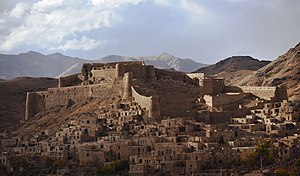
Rahmanniyeh Castle
| Rahmanniyeh Castle | |
|---|---|
قلعه رحمانیه | |
 | |
 | |
| General information | |
| Type | Castle |
| Town or city | Bardaskan County |
| Country | |
| Coordinates | 35°03′37″N 57°53′06″E / 35.0603°N 57.885°E |
Rahmanniyeh Castle (Persian: قلعه رحمانیه) is a historical castle located in Bardaskan County in Razavi Khorasan Province, The longevity of this fortress dates back to the 8th to 12th centuries AH.[1][2]
References
- ^ "بردسكن ديار ميراث تاريخي، ميزبان گردشگران". Islamic Republic News Agency. Retrieved 12 February 2021.
- ^ "قلعه رحمانیه". seeiran.ir. Retrieved 12 February 2021.


This article about a castle in Iran is a stub. You can help Wikipedia by expanding it. |