Peoria, Illinois, metropolitan area: Difference between revisions
No edit summary |
No edit summary |
||
| Line 1: | Line 1: | ||
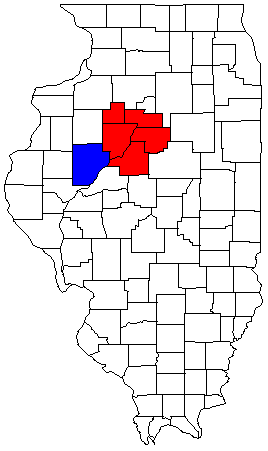
[[File:Peoria metropolitan area.svg|thumb|right|200px|Map of Illinois highlighting the Peoria Metropolitan Statistical Area.]] |
[[File:Peoria metropolitan area.svg|thumb|right|200px|Map of Illinois highlighting the Peoria Metropolitan Statistical Area.]] |
||
The '''Peoria Metropolitan Statistical Area''', as defined by the [[United States Census Bureau]], is an area consisting of six counties in [[Central Illinois|Central]] [[Illinois]], anchored by the city of [[Peoria, Illinois|Peoria]]. As of the [[United States Census, 2020|2020 census]], the MSA had a population of 402,391.{cite web | https://www.citypopulation.de/en/usa/metro/37900__peoria/ |
The '''Peoria Metropolitan Statistical Area''', as defined by the [[United States Census Bureau]], is an area consisting of six counties in [[Central Illinois|Central]] [[Illinois]], anchored by the city of [[Peoria, Illinois|Peoria]]. As of the [[United States Census, 2020|2020 census]], the MSA had a population of 402,391.[[{cite web | https://www.citypopulation.de/en/usa/metro/37900__peoria/ </ref> The City of Peoria, according to the 2020 US Census Bureau, has 113,150 people.<ref>{{Cite web|title = Peoria (city) QuickFacts from the US Census Bureau|url = http://quickfacts.census.gov/qfd/states/17/1759000.html|</ref> |
||
==Counties== |
==Counties== |
||
Revision as of 22:36, 15 October 2021

The Peoria Metropolitan Statistical Area, as defined by the United States Census Bureau, is an area consisting of six counties in Central Illinois, anchored by the city of Peoria. As of the 2020 census, the MSA had a population of 402,391.[[{cite web | https://www.citypopulation.de/en/usa/metro/37900__peoria/ </ref> The City of Peoria, according to the 2020 US Census Bureau, has 113,150 people.[1]
Counties
Communities
| Census | Pop. | Note | %± |
|---|---|---|---|
| 1900 | 121,629 | — | |
| 1910 | 134,282 | 10.4% | |
| 1920 | 150,250 | 11.9% | |
| 1930 | 187,426 | 24.7% | |
| 1940 | 211,736 | 13.0% | |
| 1950 | 250,512 | 18.3% | |
| 1960 | 334,898 | 33.7% | |
| 1970 | 362,791 | 8.3% | |
| 1980 | 387,732 | 6.9% | |
| 1990 | 358,552 | −7.5% | |
| 2000 | 366,899 | 2.3% | |
| 2010 | 379,186 | 3.3% | |
| 2020 | 402,391 | 6.1% | |
| 2019 (est.) | 373,590 | −1.5% | |
| U.S. Decennial Census[2] | |||
Places with more than 100,000 inhabitants
- Peoria (principal city)
Places with 10,000 to 40,000 inhabitants
Places with 2,500 to 10,000 inhabitants
- Bartonville
- Chillicothe
- Creve Coeur
- Farmington
- Germantown Hills
- El Paso (partial)
- Eureka
- Henry
- Marquette Heights
- Metamora
- Peoria Heights
- Tremont
- West Peoria
Places with 1,000 to 2,500 inhabitants
- Bellevue
- Delavan
- Elmwood
- Glasford
- Hanna City
- Lacon
- Mackinaw
- Minier
- Minonk
- North Pekin
- Princeville
- Roanoke
- Rome (census-designated place)
- South Pekin
- Toluca
- Toulon
- Washburn
- Wenona (partial)
- Wyoming
Places with fewer than 1,000 inhabitants
Unincorporated places
- Alta
- Broadmoor
- Camp Grove
- Castleton
- Cramers
- Edelstein
- Edgewater
- Edwards
- El Vista
- Elmore
- Galena Knolls
- Groveland
- High Meadows
- Holmes Center
- Hopewell Estates
- Komatsu Dresser
- Lake Camelot
- Lake Lancelot
- Lake of the Woods
- Laura
- Lawn Ridge
- Leeds
- Lombardville
- Lowpoint
- Mardell Manor
- Modena
- Monica
- Mossville
- North Hampton
- Oak Hill
- Oak Ridge
- Orchard Mines
- Pattonsburg
- Pottstown
- Renchville
- Rome Heights
- Saratoga Center
- Saxton
- Smithville
- South Rome
- Southport
- Speer
- Spires
- Tuscarora
- Vets Row
- Vonachen Knolls
- West Hallock
- Wilbern
- Woodford
Townships
- Akron
- Bell Plain
- Bennington
- Boynton
- Brimfield
- Cazenovia
- Chillicothe
- Cincinnati
- Clayton
- Cruger
- Deer Creek
- Delavan
- Dillon
- El Paso
- Elm Grove
- Elmira
- Elmwood
- Essex
- Evans
- Fondulac
- Goshen
- Greene
- Groveland
- Hallock
- Henry
- Hittle
- Hollis
- Hopedale
- Hopewell
- Jubilee
- Kansas
- Kickapoo
- La Prairie
- Lacon
- Limestone
- Linn
- Little Mackinaw
- Logan
- Mackinaw
- Malone
- Medina
- Metamora
- Millbrook
- Minonk
- Montgomery
- Morton
- Olio
- Osceola
- Palestine
- Panola
- Partridge
- Pekin
- Penn
- Princeville
- Radnor
- Richland
- Richwoods
- Roanoke
- Roberts
- Rosefield
- Sand Prairie
- Saratoga
- Spring Bay
- Spring Lake
- Steuben
- Timber
- Toulon
- Tremont
- Trivoli
- Valley
- Washington
- West Jersey
- West Peoria
- Whitefield
- Worth
Combined Statistical Area
The Peoria–Canton Combined Statistical Area is made up of six counties in central Illinois. The statistical area includes one metropolitan area and one micropolitan area. As of the 2000 Census, the CSA had a population of 405,149 (though a July 1, 2009 estimate placed the population at 412,517).[3]
- Metropolitan Statistical Areas (MSAs)
- Peoria (Marshall, Peoria, Stark, Tazewell and Woodford counties)
- Micropolitan Statistical Areas (μSAs)
- Canton (Fulton County)
Demographics
As of the census[4] of 2000, there were 366,899 people, 143,607 households, and 98,299 families residing within the MSA. The racial makeup of the MSA was 88.54% White, 8.40% African American, 0.23% Native American, 1.05% Asian, 0.02% Pacific Islander, 0.59% from other races, and 1.18% from two or more races. Hispanic or Latino of any race were 1.52% of the population.
The median income for a household in the MSA was $42,805, and the median income for a family was $50,756. Males had a median income of $38,135 versus $23,793 for females. The per capita income for the MSA was $20,104.
See also
References
- ^ {{Cite web|title = Peoria (city) QuickFacts from the US Census Bureau|url = http://quickfacts.census.gov/qfd/states/17/1759000.html%7C
- ^ "U.S. Decennial Census". United States Census Bureau. Archived from the original on May 12, 2015. Retrieved April 12, 2020.
- ^ "Table 2. Annual Estimates of the Population of Combined Statistical Areas: April 1, 2000 to July 1, 2009 (CBSA-EST2009-02)". 2009 Population Estimates. United States Census Bureau, Population Division. 2010-03-23. Archived from the original (CSV) on April 20, 2010. Retrieved 2010-03-26.
- ^ "U.S. Census website". United States Census Bureau. Retrieved 2008-01-31.

Springfield (capital) | |
| Topics |
|
| Regions |
|
| Municipalities |
|
| Counties |
|