Kirchheim im Innkreis: Difference between revisions
Content deleted Content added
Zackmann08 (talk | contribs) |
m →References: add authority control |
||
| (2 intermediate revisions by 2 users not shown) | |||
| Line 36: | Line 36: | ||
| leader_name1 = |
| leader_name1 = |
||
<!-- Statistics --> |
<!-- Statistics --> |
||
| area_footnotes = {{Austria population Wikidata|area_footnotes}} |
|||
| area_total_km2 = 10 |
|||
| area_total_km2 = {{Austria population Wikidata|area_total_km2}} |
|||
| area_metro_km2 = |
| area_metro_km2 = |
||
| elevation_m = 429 |
| elevation_m = 429 |
||
| elevation_max_m = |
| elevation_max_m = |
||
| elevation_min_m = |
| elevation_min_m = |
||
| population_as_of = {{Austria population Wikidata|population_as_of}} |
|||
| population_total = 718 |
|||
| population_footnotes = {{Austria population Wikidata|population_footnotes}} |
|||
| population_as_of = 14 June 2016 |
|||
| population_total = {{Austria population Wikidata|population_total}} |
|||
| population_footnotes = <ref>[http://www.statistik.at/wcm/idc/idcplg?IdcService=GET_NATIVE_FILE&RevisionSelectionMethod=LatestReleased&dDocName=080904 Statistik Austria - Bevölkerung zu Jahresbeginn 2002-2016 nach Gemeinden, Erstellt am 14.06.2016 (Last accessed 13.12.2016)] for Kirchheim im Innkreis. </ref> |
|||
| population_urban = |
| population_urban = |
||
| population_metro = |
| population_metro = |
||
| Line 88: | Line 89: | ||
{{reflist}} |
{{reflist}} |
||
{{commons category}} |
|||
{{commonscat}} |
|||
{{Cities and towns in Ried im Innkreis (district)}} |
{{Cities and towns in Ried im Innkreis (district)}} |
||
{{authority control}} |
|||
[[Category:Cities and towns in Ried im Innkreis District]] |
|||
Latest revision as of 22:04, 2 April 2020
Kirchheim im Innkreis | |
|---|---|
 | |
 Coat of arms | |
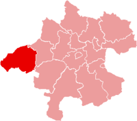
 Kirchheim im Innkreis Location within Austria | |
| Coordinates: 48°12′35″N 13°21′40″E / 48.20972°N 13.36111°E | |
| Country | Austria |
| State | Upper Austria |
| District | Ried im Innkreis |
| Government | |
| • Mayor | Johann Hartl (ÖVP) |
| Area | |
| • Total | 10.26 km2 (3.96 sq mi) |
| Elevation | 429 m (1,407 ft) |
| Population (2018-01-01)[2] | |
| • Total | 716 |
| • Density | 70/km2 (180/sq mi) |
| Time zone | UTC+1 (CET) |
| • Summer (DST) | UTC+2 (CEST) |
| Postal code | 4932 |
| Area code | 07755 |
| Vehicle registration | RI |
| Website | www.kirchheim.at |
Kirchheim im Innkreis is a municipality in the district of Ried im Innkreis in the Austrian state of Upper Austria.
Population[edit]
| Year | Pop. | ±% |
|---|---|---|
| 1869 | 684 | — |
| 1880 | 649 | −5.1% |
| 1890 | 631 | −2.8% |
| 1900 | 600 | −4.9% |
| 1910 | 607 | +1.2% |
| 1923 | 596 | −1.8% |
| 1934 | 597 | +0.2% |
| 1939 | 595 | −0.3% |
| 1951 | 710 | +19.3% |
| 1961 | 570 | −19.7% |
| 1971 | 580 | +1.8% |
| 1981 | 588 | +1.4% |
| 1991 | 619 | +5.3% |
| 2001 | 704 | +13.7% |
| 2013 | 704 | +0.0% |
References[edit]
- ^ "Dauersiedlungsraum der Gemeinden Politischen Bezirke und Bundesländer - Gebietsstand 1.1.2018". Statistics Austria. Retrieved 10 March 2019.
- ^ "Einwohnerzahl 1.1.2018 nach Gemeinden mit Status, Gebietsstand 1.1.2018". Statistics Austria. Retrieved 9 March 2019.
Wikimedia Commons has media related to Kirchheim im Innkreis.
| International | |
|---|---|
| National | |
This Upper Austria location article is a stub. You can help Wikipedia by expanding it. |