Kirchheim im Innkreis: Difference between revisions
Content deleted Content added
m r2.7.3) (Robot: Adding kk:Кирхгайм (Инкрайс) |
m →References: add authority control |
||
| (11 intermediate revisions by 9 users not shown) | |||
| Line 1: | Line 1: | ||
{{Infobox |
{{Infobox settlement |
||
| |
| name = Kirchheim im Innkreis |
||
| native_name = |
|||
|Name = Kirchheim im Innkreis |
|||
| settlement_type = |
|||
|Wappen = Wappen at kirchheim-im-innkreis.png |
|||
<!-- Images --> |
|||
|lat_deg = 48 | lat_min = 12 | lat_sec = 35 |
|||
| image_skyline = 08-07-19+13-24-32+Kirchheim i.I., Pfarrkirche Hl. Nikolaus.jpg |
|||
|lon_deg = 13 | lon_min = 21 | lon_sec = 40 |
|||
| |
| imagesize = |
||
| image_caption = |
|||
|Bezirk = Ried im Innkreis |
|||
| image_shield = Wappen at kirchheim-im-innkreis.png |
|||
|Höhe = 429 |
|||
| |
| shield_size = 80x110px |
||
| |
| shield_link = |
||
<!-- Maps --> |
|||
| |
| pushpin_map = Austria |
||
| |
| pushpin_mapsize = 270 |
||
| pushpin_map_caption = Location within Austria |
|||
|Kfz = RI |
|||
| image_map = |
|||
|Gemeindekennziffer = 4 12 11 |
|||
| |
| mapsize = |
||
| |
| map_alt = |
||
| map_caption = Location within Ried im Innkreis district |
|||
|Website = [http://www.kirchheim.at www.kirchheim.at] |
|||
<!-- Location --> |
|||
|Bürgermeister = Johann Hartl |
|||
| coordinates = {{coord|48|12|35|N|13|21|40|E|display=inline,title}} |
|||
|Partei = ÖVP |
|||
| subdivision_type = Country |
|||
|Gemeinderatanzahl = 13 |
|||
| subdivision_name = [[Austria]] |
|||
|Gemeinderat = 6 [[ÖVP]], 4 [[SPÖ]], 3 [[FPÖ]] |
|||
| subdivision_type1 = [[States of Austria|State]] |
|||
|Wahljahr = 2003 |
|||
| subdivision_name1 = [[Upper Austria]] |
|||
| subdivision_type2 = [[District (Austria)|District]] |
|||
| subdivision_name2 = [[Ried im Innkreis District|Ried im Innkreis]] |
|||
| parts_type = |
|||
| parts_style = para |
|||
| p1 = |
|||
<!-- Leaders --> |
|||
| leader_title = [[Burgomaster|Mayor]] |
|||
| leader_name = Johann Hartl |
|||
| leader_party = {{Polparty|Austria| ÖVP }} |
|||
| leader_title1 = |
|||
| leader_name1 = |
|||
<!-- Statistics --> |
|||
| area_footnotes = {{Austria population Wikidata|area_footnotes}} |
|||
| area_total_km2 = {{Austria population Wikidata|area_total_km2}} |
|||
| area_metro_km2 = |
|||
| elevation_m = 429 |
|||
| elevation_max_m = |
|||
| elevation_min_m = |
|||
| population_as_of = {{Austria population Wikidata|population_as_of}} |
|||
| population_footnotes = {{Austria population Wikidata|population_footnotes}} |
|||
| population_total = {{Austria population Wikidata|population_total}} |
|||
| population_urban = |
|||
| population_metro = |
|||
| population_note = |
|||
| population_density_km2 = auto |
|||
| established_title = |
|||
| established_date = |
|||
| timezone = [[Central European Time|CET]] |
|||
| timezone_DST = [[Central European Summer Time|CEST]] |
|||
| utc_offset = +1 |
|||
| utc_offset_DST = +2 |
|||
| registration_plate = [[Vehicle registration plates of Austria|RI]] |
|||
| postal_code_type = [[List of postal codes in Austria|Postal code]] |
|||
| postal_code = 4932 |
|||
| area_code_type = [[Telephone numbers in Austria|Area code]] |
|||
| area_code = 07755 |
|||
| website = [http://www.kirchheim.at www.kirchheim.at] |
|||
| footnotes = |
|||
}} |
}} |
||
'''Kirchheim im Innkreis''' is a municipality in the district of [[Ried im Innkreis (district)|Ried im Innkreis]] in [[ |
'''Kirchheim im Innkreis''' is a municipality in the district of [[Ried im Innkreis (district)|Ried im Innkreis]] in the [[Austria]]n state of [[Upper Austria]]. |
||
==Population== |
|||
{{Historical populations |
|||
|align=left |
|||
|1869|684 |
|||
|1880|649 |
|||
|1890|631 |
|||
|1900|600 |
|||
|1910|607 |
|||
|1923|596 |
|||
|1934|597 |
|||
|1939|595 |
|||
|1951|710 |
|||
|1961|570 |
|||
|1971|580 |
|||
|1981|588 |
|||
|1991|619 |
|||
|2001|704 |
|||
|2013|704 |
|||
}} |
|||
{{clear-left}} |
|||
==References== |
==References== |
||
{{reflist}} |
{{reflist}} |
||
{{commons category}} |
|||
{{Cities and towns in Ried im Innkreis (district)}} |
{{Cities and towns in Ried im Innkreis (district)}} |
||
{{authority control}} |
|||
[[Category:Cities and towns in Ried im Innkreis District]] |
|||
{{UpperAustria-geo-stub}} |
|||
[[de:Kirchheim im Innkreis]] |
|||
{{UpperAustria-geo-stub}} |
|||
[[fr:Kirchheim im Innkreis]] |
|||
[[it:Kirchheim im Innkreis]] |
|||
[[kk:Кирхгайм (Инкрайс)]] |
|||
[[nl:Kirchheim im Innkreis]] |
|||
[[pt:Kirchheim im Innkreis]] |
|||
[[ru:Кирхгайм (Инкрайс)]] |
|||
[[sk:Kirchheim im Innkreis]] |
|||
[[vi:Kirchheim im Innkreis]] |
|||
[[vo:Kirchheim im Innkreis]] |
|||
[[war:Kirchheim im Innkreis]] |
|||
Latest revision as of 22:04, 2 April 2020
Kirchheim im Innkreis | |
|---|---|
 | |
 Coat of arms | |
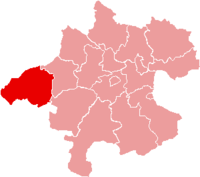
 Kirchheim im Innkreis Location within Austria | |
| Coordinates: 48°12′35″N 13°21′40″E / 48.20972°N 13.36111°E | |
| Country | Austria |
| State | Upper Austria |
| District | Ried im Innkreis |
| Government | |
| • Mayor | Johann Hartl (ÖVP) |
| Area | |
| • Total | 10.26 km2 (3.96 sq mi) |
| Elevation | 429 m (1,407 ft) |
| Population (2018-01-01)[2] | |
| • Total | 716 |
| • Density | 70/km2 (180/sq mi) |
| Time zone | UTC+1 (CET) |
| • Summer (DST) | UTC+2 (CEST) |
| Postal code | 4932 |
| Area code | 07755 |
| Vehicle registration | RI |
| Website | www.kirchheim.at |
Kirchheim im Innkreis is a municipality in the district of Ried im Innkreis in the Austrian state of Upper Austria.
Population[edit]
| Year | Pop. | ±% |
|---|---|---|
| 1869 | 684 | — |
| 1880 | 649 | −5.1% |
| 1890 | 631 | −2.8% |
| 1900 | 600 | −4.9% |
| 1910 | 607 | +1.2% |
| 1923 | 596 | −1.8% |
| 1934 | 597 | +0.2% |
| 1939 | 595 | −0.3% |
| 1951 | 710 | +19.3% |
| 1961 | 570 | −19.7% |
| 1971 | 580 | +1.8% |
| 1981 | 588 | +1.4% |
| 1991 | 619 | +5.3% |
| 2001 | 704 | +13.7% |
| 2013 | 704 | +0.0% |
References[edit]
- ^ "Dauersiedlungsraum der Gemeinden Politischen Bezirke und Bundesländer - Gebietsstand 1.1.2018". Statistics Austria. Retrieved 10 March 2019.
- ^ "Einwohnerzahl 1.1.2018 nach Gemeinden mit Status, Gebietsstand 1.1.2018". Statistics Austria. Retrieved 9 March 2019.
Wikimedia Commons has media related to Kirchheim im Innkreis.
| International | |
|---|---|
| National | |
This Upper Austria location article is a stub. You can help Wikipedia by expanding it. |