Gê'gyai County: Difference between revisions
Content deleted Content added
Reverted 1 edit by 113.62.100.54 (talk): Whaterss sock. (TW) |
Rescuing 1 sources and tagging 0 as dead.) #IABot (v2.0.9.5 |
||
| (14 intermediate revisions by 11 users not shown) | |||
| Line 1: | Line 1: | ||
{{ |
{{one source|date=October 2020}} |
||
{{Infobox settlement |
{{Infobox settlement |
||
<!--See Template:Infobox Settlement for additional fields that may be available--> |
<!--See Template:Infobox Settlement for additional fields that may be available--> |
||
<!--See the Table at Infobox Settlement for all fields and descriptions of usage--> |
<!--See the Table at Infobox Settlement for all fields and descriptions of usage--> |
||
<!-- Basic info ----------------> |
<!-- Basic info ---------------->| name = Gê'gyai County |
||
| |
| official_name = |
||
| |
| other_name = |
||
| ⚫ | |||
| |
| nickname = |
||
| ⚫ | |||
| |
| settlement_type = [[County (People's Republic of China)|County]] |
||
| total_type = <!-- to set a non-standard label for total area and population rows --> |
|||
|settlement_type =[[County (People's Republic of China)|County]] |
|||
| |
| motto = <!-- images and maps -----------> |
||
| |
| image_skyline = |
||
| ⚫ | |||
<!-- images and maps -----------> |
|||
| |
| image_caption = |
||
| image_map = Location of Gê'gyai within Xizang (China).png |
|||
| ⚫ | |||
| |
| mapsize = 250px |
||
| |
| map_caption = Location of Gê'gyai County (red) within Ngari Prefecture (yellow) and the Tibet Autonomous Region |
||
| |
| pushpin_map = China Tibet Ngari#Tibet#China |
||
| ⚫ | |||
|map_caption =Location of Gê'gyai County (red) within Ngari Prefecture (yellow) and the Tibet A.R. |
|||
| |
| pushpin_label_position = |
||
| ⚫ | |||
| ⚫ | |||
| ⚫ | |||
|pushpin_label_position = |
|||
| ⚫ | |||
| ⚫ | |||
| |
| subdivision_name = [[China]] |
||
| ⚫ | |||
| ⚫ | |||
| ⚫ | |||
| ⚫ | |||
| |
| subdivision_type2 = [[Prefectures of the People's Republic of China|Prefecture]] |
||
| ⚫ | |||
| ⚫ | |||
|seat_type = County seat |
|||
| ⚫ | |||
|seat = [[Geji, Gê'gyai County|Gê'gyai]] |
|||
|subdivision_type2 = [[Prefectures of the People's Republic of China|Prefecture]] |
|||
| ⚫ | |||
|subdivision_type3 = |
|||
|subdivision_name3 = |
|||
<!-- Politics -----------------> |
<!-- Politics -----------------> |
||
|leader_title = |
| leader_title = |
||
|leader_name = |
| leader_name = |
||
|established_title |
| established_title = |
||
|established_date = |
| established_date = |
||
|area_total_km2 = |
| area_total_km2 = 46,104.28 |
||
|elevation_m = |
| elevation_m = |
||
|population_as_of = |
| population_as_of = 2020 |
||
| population_footnotes = <ref>{{cite web |url = https://www.al.gov.cn/info/1097/39636.htm |title = 阿里地区第七次全国人口普查主要数据公报 |publisher = Administrative Commission of Ngari Prefecture |language = zh |date = 2021-06-10 |access-date = 2023-08-19 |archive-date = 2022-06-11 |archive-url = https://web.archive.org/web/20220611003714/https://www.al.gov.cn/info/1097/39636.htm |url-status = dead }}</ref> |
|||
|population_footnotes = |
|||
|population_note = |
| population_note = |
||
|population_total = |
| population_total = 18012 |
||
|population_density_km2 = |
| population_density_km2 = auto |
||
<!-- General information ---------------> |
<!-- General information ---------------> |
||
|timezone = [[China Standard Time|China Standard]] |
| timezone = [[China Standard Time|China Standard]] |
||
|utc_offset = +8 |
| utc_offset = +8 |
||
| coor_type = <!-- can be used to specify what the coordinates refer to --> |
| coor_type = <!-- can be used to specify what the coordinates refer to --> |
||
|coordinates = {{coord|31|57|21|N|81|56|53|E|type:adm3rd_region:CN-54_source:dewiki|display=inline,title}} |
| coordinates = {{coord|31|57|21|N|81|56|53|E|type:adm3rd_region:CN-54_source:dewiki|display=inline,title}} |
||
<!-- Area/postal codes & others --------> |
<!-- Area/postal codes & others -------->| postal_code_type = |
||
| |
| postal_code = |
||
| |
| area_code = |
||
| |
| website = {{URL|https://gj.al.gov.cn}} |
||
| |
| footnotes = |
||
| ⚫ | |||
|footnotes = |
|||
{{Infobox Chinese |
|||
| ⚫ | |||
|tib=དགེ་རྒྱས་རྫོང་། |wylie=dge rgyas rdzong |zwpy=Gê'gyai Zong |
|||
|order=st |s=革吉县 |t=革吉縣 |p=Géjí Xiàn }} |
|||
'''Gê'gyai County''' ({{bo|t=དགེ་རྒྱས་རྫོང་།}}, {{zh|s=革吉县}}) is a county in [[Ngari Prefecture]] of the [[Tibet Autonomous Region]], China. 'Gê'gyai' is Tibetan for "full beauty". |
|||
==Administrative divisions== |
|||
Lake Donggu ({{zh|labels=no |s=洞古错 |t=洞古錯 |p=dònggǔcuò}} is located in Gê'gyai County. |
|||
Gê'gyai county is divided into 1 [[Towns of the People's Republic of China|town]] and 4 [[Townships of the People's Republic of China|townships]]: |
|||
{| class="wikitable" style="font-size:90%;" align=center |
|||
! Name |
|||
! [[Standard Chinese|Chinese]] |
|||
! [[Hanyu Pinyin]] |
|||
! [[Standard Tibetan|Tibetan]] |
|||
! [[Wylie transliteration|Wylie]] |
|||
|---------- |
|||
| colspan="5" style="text-align:center; background:#d3d3d3;"|'''Town''' |
|||
|---------- |
|||
| [[Geji, Gê'gyai County|Gê'gyai Town]] |
|||
|{{lang|zh-hans|革吉镇}} |
|||
| {{transl|zh|Géjí zhèn}} |
|||
|{{bo-textonly|དགེ་རྒྱས་གྲོང་རྡལ།}} |
|||
|{{transl|bo|dge rgyas grong rdal}} |
|||
|---------- |
|||
| colspan="5" style="text-align:center; background:#d3d3d3;"|'''Townships''' |
|||
|---------- |
|||
| [[Zhungpa Township]] |
|||
|{{lang|zh-hans|雄巴乡}} |
|||
| {{transl|zh|Xióngbā xiāng}} |
|||
|{{bo-textonly|གཞུང་པ་ཤང་།}} |
|||
|{{transl|bo|gzhung pa shang}} |
|||
|- |
|||
| [[Yagra Township]] |
|||
|{{lang|zh-hans|亚热乡}} |
|||
| {{transl|zh|Yàrè xiāng}} |
|||
|{{bo-textonly|ཡག་རྭ་ཤང་།}} |
|||
|{{transl|bo|yag rwa shang}} |
|||
|- |
|||
| [[Yanhu Township|Chaco Township]]<br>(Yanhu) |
|||
|{{lang|zh-hans|盐湖乡}} |
|||
| {{transl|zh|Yánhú xiāng}} |
|||
|{{bo-textonly|ཚྭ་མཚོ་ཤང་།}} |
|||
|{{transl|bo|tshwa mtsho shang}} |
|||
|- |
|||
| [[Wönpo Tamzang Township]] |
|||
|{{lang|zh-hans|文布当桑乡}} |
|||
| {{transl|zh|Wénbùdāngsāng xiāng}} |
|||
|{{bo-textonly|བོན་པོ་གཏམ་བཟང་ཤང་།}} |
|||
|{{transl|bo|bon po gtam bzang shang}} |
|||
|- |
|||
|} |
|||
== Demography == |
|||
Population of this district was {{formatnum:12313}} inhabitants in 1999.<ref>National Population Statistics Materials by County and City - 1999 Period, ''in'' [http://www.people.fas.harvard.edu/~chgis/work/downloads/faqs/1999_pop_faq.html China County & City Population 1999, Harvard China Historical GIS]</ref> |
|||
== References == |
|||
<references /> |
|||
{{County-level divisions of Tibet}} |
{{County-level divisions of Tibet}} |
||
| Line 67: | Line 116: | ||
[[Category:Counties of Tibet]] |
[[Category:Counties of Tibet]] |
||
[[Category:Ngari Prefecture]] |
[[Category:Ngari Prefecture]] |
||
{{Ngari-geo-stub}} |
{{Ngari-geo-stub}} |
||
Latest revision as of 11:01, 2 July 2024
This article relies largely or entirely on a single source. (October 2020) |
Gê'gyai County
革吉县 • དགེ་རྒྱས་རྫོང་། | |
|---|---|
 Location of Gê'gyai County (red) within Ngari Prefecture (yellow) and the Tibet Autonomous Region | |
 Gê'gyai Location of the seat in the Tibet Autonomous Region  Gê'gyai Gê'gyai (Tibet)  Gê'gyai Gê'gyai (China) | |
| Coordinates: 31°57′21″N 81°56′53″E / 31.95583°N 81.94806°E | |
| Country | China |
| Autonomous region | Tibet |
| Prefecture | Ngari |
| County seat | Gê'gyai |
| Area | |
| • Total | 46,104.28 km2 (17,800.96 sq mi) |
| Population (2020)[1] | |
| • Total | 18,012 |
| • Density | 0.39/km2 (1.0/sq mi) |
| Time zone | UTC+8 (China Standard) |
| Website | gj |
| Gê'gyai County | |||||||
|---|---|---|---|---|---|---|---|
| Chinese name | |||||||
| Simplified Chinese | 革吉县 | ||||||
| Traditional Chinese | 革吉縣 | ||||||
| |||||||
| Tibetan name | |||||||
| Tibetan | དགེ་རྒྱས་རྫོང་། | ||||||
| |||||||
Gê'gyai County (Tibetan: དགེ་རྒྱས་རྫོང་།, Chinese: 革吉县) is a county in Ngari Prefecture of the Tibet Autonomous Region, China. 'Gê'gyai' is Tibetan for "full beauty".
Administrative divisions[edit]
Gê'gyai county is divided into 1 town and 4 townships:
| Name | Chinese | Hanyu Pinyin | Tibetan | Wylie |
|---|---|---|---|---|
| Town | ||||
| Gê'gyai Town | 革吉镇 | Géjí zhèn | དགེ་རྒྱས་གྲོང་རྡལ། | dge rgyas grong rdal |
| Townships | ||||
| Zhungpa Township | 雄巴乡 | Xióngbā xiāng | གཞུང་པ་ཤང་། | gzhung pa shang |
| Yagra Township | 亚热乡 | Yàrè xiāng | ཡག་རྭ་ཤང་། | yag rwa shang |
| Chaco Township (Yanhu) |
盐湖乡 | Yánhú xiāng | ཚྭ་མཚོ་ཤང་། | tshwa mtsho shang |
| Wönpo Tamzang Township | 文布当桑乡 | Wénbùdāngsāng xiāng | བོན་པོ་གཏམ་བཟང་ཤང་། | bon po gtam bzang shang |
Demography[edit]
Population of this district was 12,313 inhabitants in 1999.[2]
References[edit]
- ^ "阿里地区第七次全国人口普查主要数据公报" (in Chinese). Administrative Commission of Ngari Prefecture. 2021-06-10. Archived from the original on 2022-06-11. Retrieved 2023-08-19.
- ^ National Population Statistics Materials by County and City - 1999 Period, in China County & City Population 1999, Harvard China Historical GIS
| County-level divisions | 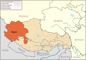 | |
|---|---|---|
| Towns and villages | ||
| Geography | ||
| Landmarks | ||
This Ngari Prefecture, Tibet location article is a stub. You can help Wikipedia by expanding it. |