Delhi–Multan road: Difference between revisions
→Route: Distance |
m rv sock edits per WP:BMB |
||
| (6 intermediate revisions by 5 users not shown) | |||
| Line 1: | Line 1: | ||
{{Use dmy dates|date=October 2017}} |
{{Use dmy dates|date=October 2017}} |
||
{{Use Indian English|date=October 2017}} |
{{Use Indian English|date=October 2017}} |
||
[[File:Roadevol.svg|thumb|right|Evolution of Indian trade networks. The main map shows the routes since [[Mughal empire|Mughal times]], Inset A: shows the major prehistorical cultural currents, B: pre-[[Maurya]]n routes, C: Mauryan routes, D: routes c. 1st century CE, and E: the |
[[File:Roadevol.svg|thumb|right|Evolution of Indian trade networks. The main map shows the routes since [[Mughal empire|Mughal times]], Inset A: shows the major prehistorical cultural currents, B: pre-[[Maurya]]n routes, C: Mauryan routes, D: routes c. 1st century CE, and E: the Z-shaped region of developed roads.]] |
||
[[File:Ancient Khorasan highlighted.jpg|thumb|Names of territories during the [[Caliphate]] in 750 CE.]] |
[[File:Ancient Khorasan highlighted.jpg|thumb|Names of territories during the [[Caliphate]] in 750 CE.]] |
||
[[File:Map of Afghanistan during the Safavid and Moghul Empire.jpg|thumb|An accurate map of Persia by [[Emanuel Bowen]] showing the names of territories during the Persian [[Safavid dynasty]] and [[Mughal Empire]] of India ([[Wiktionary:circa|ca.]] 1500–1747)]] |
[[File:Map of Afghanistan during the Safavid and Moghul Empire.jpg|thumb|An accurate map of Persia by [[Emanuel Bowen]] showing the names of territories during the Persian [[Safavid dynasty]] and [[Mughal Empire]] of India ([[Wiktionary:circa|ca.]] 1500–1747)]] |
||
| Line 12: | Line 12: | ||
== Route == |
== Route == |
||
On the Indian side, it passed through [[Rohtak]], [[Panipat]], [[Karnal]], [[Kurukshetra]], [[Ambala]], [[Rajpura]], [[Sirhind]], [[Ludhiana]], [[Firozpur]], [[Hussainiwala]] etc. Part from [[Delhi]] to [[Ludhiana]] falls under [[National Highway 44]] of India. Distance traversed in India is {{convert|500|km|mi}} |
On the Indian side, it passed through the cities of [[Rohtak]], [[Panipat]], [[Karnal]], [[Kurukshetra]], [[Ambala]], [[Rajpura]], [[Sirhind]], [[Ludhiana]], [[Firozpur]], [[Hussainiwala]] etc. Part from [[Delhi]] to [[Ludhiana]] falls under [[National Highway 44]] of India. Distance traversed in India is {{convert|500|km|mi}} |
||
On the Pakistani side, the road goes through the cities |
On the Pakistani side, the road goes through the cities of [[Kasur]], [[Raiwind]], [[Lahore]], [[Nankana Sahab]], [[Harapa]], [[Chichawatni]], [[Tulamba]], [[Makhdumpur]], [[Kabirwala]] and finally [[Multan]]. Sher Shah also built a fort in Tulamba City to make a strong Communication path from Multan to Delhi. Distance traversed in Pakistan is {{convert|589|km|mi}}. |
||
Then from [[Multan]] it led to [[Kandhar]] in Afghanistan, and then on to [[Herat]], traversing another {{convert| |
Then from [[Multan]] it led to [[Kandhar]] in Afghanistan, and then on to [[Herat]], traversing another {{convert|599|km|mi}}. |
||
Again from [[Herat]] it led to capital city [[Mashhad]] of [[Khorasan Province|Khorasan]] province of [[Iran]], traversing another {{convert| |
Again from [[Herat]] it led to capital city [[Mashhad]] of [[Khorasan Province|Khorasan]] province of [[Iran]], traversing another {{convert|576|km|mi}} |
||
Finally from [[Mashhad]] in [[Iran]], it eventually led to capital city [[Ashgabat]] of [[Ashgabat]] Province in [[Turkmenistan]], traversing final {{convert| |
Finally from [[Mashhad]] in [[Iran]], it eventually led to capital city [[Ashgabat]] of [[Ashgabat]] Province in [[Turkmenistan]], traversing final {{convert|652|km|mi}} |
||
From Delhi to Ashgabat, the road traverses for {{convert|2916|km|mi}} & was an important roadway of [[Asia]] during medieval era. |
From Delhi to Ashgabat, the road traverses for {{convert|2916|km|mi}} & was an important roadway of [[Asia]] during medieval era. |
||
Latest revision as of 22:54, 11 June 2024

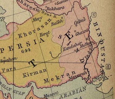

Delhi–Multan road, an ancient route had existed since the time of king Ashoka or earlier, was renovated by the Sur Empire ruler Sher Shah Suri (1486–1545) in order to improve transit in the areas between Delhi and Multan, leading to Kandahar and Herat in Afghanistan, eventually to Mashhad capital of Khorasan province of Iran, providing access to capital city Ashgabat of Turkmenistan."[1]
Messaging System[edit]
There were small posts every few miles where horses were ready to receive messages to send from one post to another. Messages from the Delhi court were reaching Multan, which was around 500 miles away, within days.[1]
Route[edit]
On the Indian side, it passed through the cities of Rohtak, Panipat, Karnal, Kurukshetra, Ambala, Rajpura, Sirhind, Ludhiana, Firozpur, Hussainiwala etc. Part from Delhi to Ludhiana falls under National Highway 44 of India. Distance traversed in India is 500 kilometres (310 mi)
On the Pakistani side, the road goes through the cities of Kasur, Raiwind, Lahore, Nankana Sahab, Harapa, Chichawatni, Tulamba, Makhdumpur, Kabirwala and finally Multan. Sher Shah also built a fort in Tulamba City to make a strong Communication path from Multan to Delhi. Distance traversed in Pakistan is 589 kilometres (366 mi).
Then from Multan it led to Kandhar in Afghanistan, and then on to Herat, traversing another 599 kilometres (372 mi).
Again from Herat it led to capital city Mashhad of Khorasan province of Iran, traversing another 576 kilometres (358 mi)
Finally from Mashhad in Iran, it eventually led to capital city Ashgabat of Ashgabat Province in Turkmenistan, traversing final 652 kilometres (405 mi)
From Delhi to Ashgabat, the road traverses for 2,916 kilometres (1,812 mi) & was an important roadway of Asia during medieval era.
See also[edit]
References[edit]
- ^ a b "Khurasan", The Encyclopaedia of Islam. Brill. 1967. Retrieved 22 October 2010.