Cleburne County, Alabama: Difference between revisions
No edit summary |
2023 census data |
||
| (114 intermediate revisions by 68 users not shown) | |||
| Line 1: | Line 1: | ||
{{short description|County in Alabama, United States}} |
|||
{{Use mdy dates|date=February 2012}} |
{{Use mdy dates|date=February 2012}} |
||
{{Infobox U.S. |
{{Infobox U.S. county |
||
| county = Cleburne County |
| county = Cleburne County |
||
| state = Alabama |
| state = Alabama |
||
| flag = Flag_of_Cleburne_County,_Alabama.svg |
|||
| seal = |
|||
| type = [[County (United States)|County]] |
|||
| founded year = 1866 |
|||
| founded |
| founded year = 1866 |
||
| founded date = December 6 |
|||
| seat wl = Heflin |
|||
| |
| seat wl = Heflin |
||
| largest city wl = Heflin |
|||
| area_total_sq_mi = 561 |
|||
| area_total_sq_mi = 561 |
|||
| area_land_sq_mi = 560 |
|||
| area_land_sq_mi = 560 |
|||
| area_water_sq_mi = 0.9 |
|||
| area_water_sq_mi = 0.9 |
|||
| area percentage = (0.2%) |
|||
| area percentage = 0.2 |
|||
| census yr = 2010 |
|||
| population_as_of = 2020 |
|||
| pop = 14972 |
|||
| population_total = 15056 |
|||
| density_sq_mi = 27 |
|||
| pop_est_as_of = 2023 |
|||
| time zone = Central |
|||
| population_est = 15639 {{increase}} |
|||
| web = www.cleburnecounty.us |
|||
| population_density_sq_mi = auto |
|||
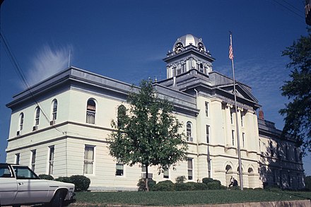
| ex image = Cleburne County Alabama Courthouse 2012.JPG |
|||
| time zone = Central |
|||
| ex image cap = Cleburne County Courthouse in Heflin in 2012 |
|||
| web = www.cleburnecounty.us |
|||
| district = 3rd |
|||
| ex image = Cleburne County Alabama Courthouse 2012.JPG |
|||
| named for = [[Patrick Cleburne]] |
|||
| ex image cap = Cleburne County Courthouse in Heflin in 2012 |
|||
| district = 3rd |
|||
| named for = [[Patrick Cleburne]] |
|||
| footnotes = |
|||
*County Number '''18''' on Alabama Licence Plates |
|||
}} |
}} |
||
'''Cleburne County''' is a [[County (United States)|county]] of the [[U.S. state]] of [[Alabama]]. As of the [[ |
'''Cleburne County''' is a [[County (United States)|county]] located in the east central portion of the [[U.S. state]] of [[Alabama]]. As of the [[2020 United States census|2020 census]], the population was 15,056.<ref name="QF">{{cite web|title=State & County QuickFacts|url=https://www.census.gov/quickfacts/fact/table/cleburnecountyalabama/PST045222|publisher=United States Census Bureau|access-date=September 10, 2023}}</ref> Its [[county seat]] is [[Heflin, Alabama|Heflin]].<ref name="GR6">{{cite web|url=http://www.naco.org/Counties/Pages/FindACounty.aspx |access-date=June 7, 2011 |title=Find a County |publisher=National Association of Counties |url-status=dead |archive-url=https://web.archive.org/web/20110531210815/http://www.naco.org/Counties/Pages/FindACounty.aspx |archive-date=May 31, 2011 |df=mdy }}</ref> Its name is in honor of [[Patrick Cleburne|Patrick R. Cleburne]] of [[Arkansas]]<ref>{{cite book | url=https://archive.org/details/bub_gb_9V1IAAAAMAAJ | title=The Origin of Certain Place Names in the United States | publisher=Govt. Print. Off. | author=Gannett, Henry | year=1905 | pages=[https://archive.org/details/bub_gb_9V1IAAAAMAAJ/page/n83 84]}}</ref> who rose to the rank of major general in the [[Confederate States Army]]. The eastern side of the county borders the state of [[Georgia (U.S. state)|Georgia]]. |
||
== |
==History== |
||
Cleburne County was established on December 6, 1866, by an act of the state legislature. |
Cleburne County was established on December 6, 1866, by an act of the state legislature. The county was made from territory in Benton (now Calhoun), Randolph, and Talladega counties. In 1867, Edwardsville was made the county seat.<ref>{{Cite web|url=http://www.archives.state.al.us/counties/cleburne.html|title=Cleburne County, Alabama history, ADAH|website=www.archives.state.al.us|access-date=June 23, 2018|archive-date=March 5, 2012|archive-url=https://web.archive.org/web/20120305013539/http://www.archives.state.al.us/counties/cleburne.html|url-status=dead}}</ref> An election was held in 1905 to move the county seat to Heflin. The result of that election, which agreed to move the seat, was appealed to the Supreme Court, who decided on July 1, 1906, to uphold the election results. Heflin is still the county seat.<ref>{{Cite web|url=http://www.cityofheflin.org/|title=City of Heflin Website - City Information - Heflin, AL|website=www.cityofheflin.org|language=en-gb|access-date=June 23, 2018}}</ref> Heflin was at one point thought of as a hub for nearby farmers to send their cotton.<ref>Cleburne County By Wayne Ruple page 33</ref> Shortly after the Civil War, a group of northern investors created the town of Fruithurst in Cleburne County as part of a wine-growing project. Fruithurst became a boomtown shortly thereafter.<ref>Cleburne County By Wayne Ruple page 11</ref> |
||
==Geography== |
==Geography== |
||
[[File:Cleburne County Courthouse.jpg|thumb|Cleburne County Courthouse in March 1980.]][[File:Cheaha Lake in the Fall.jpg|thumb|[[Cheaha Mountain]], Cleburne County]] |
[[File:Cleburne County Courthouse.jpg|thumb|Cleburne County Courthouse in March 1980.]][[File:Cheaha Lake in the Fall.jpg|thumb|[[Cheaha Mountain]], Cleburne County]] |
||
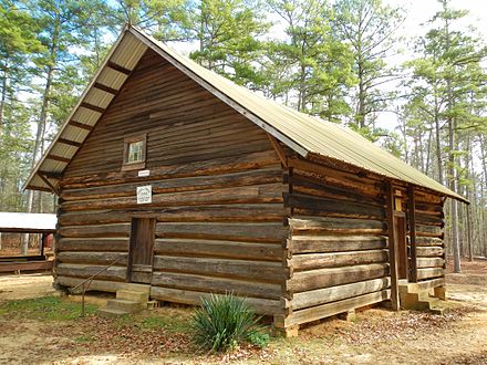
[[File:Shoal Creek Church Edwardsville Alabama.JPG|thumb|[[Shoal Creek Church]] is a historic church located in Cleburne County just north of [[Edwardsville, Alabama|Edwardsville]], Alabama in [[Talladega National Forest]]. |
[[File:Shoal Creek Church Edwardsville Alabama.JPG|thumb|[[Shoal Creek Church]] is a historic church located in Cleburne County just north of [[Edwardsville, Alabama|Edwardsville]], Alabama in [[Talladega National Forest]]. The church was built in 1895 and added to the [[National Register of Historic Places listings in Alabama#Cleburne County|National Register of Historic Places]] on December 4, 1974]] |
||
According to the [[ |
According to the [[United States Census Bureau]], the county has a total area of {{convert|561|sqmi}}, of which {{convert|560|sqmi}} is land and {{convert|0.9|sqmi}} (0.2%) is water.<ref name="GR1">{{cite web|url=http://www2.census.gov/geo/docs/maps-data/data/gazetteer/counties_list_01.txt|publisher=United States Census Bureau|access-date=August 22, 2015|date=August 22, 2012|title=2010 Census Gazetteer Files}}</ref> It is the fourth-smallest county in Alabama by land area and second-largest by total area. Cleburne County is home to Alabama's highest natural point on [[Cheaha Mountain]] which is part of the southernmost mountain range in the Blue Ridge Mountains. |
||
===Adjacent counties=== |
===Adjacent counties=== |
||
*[[Cherokee County, Alabama]] – north |
*[[Cherokee County, Alabama|Cherokee County]] – north |
||
*[[Polk County, Georgia]] – northeast |
*[[Polk County, Georgia]] – northeast |
||
*[[Haralson County, Georgia]] – east |
*[[Haralson County, Georgia]] – east |
||
*[[Carroll County, Georgia]] – southeast |
*[[Carroll County, Georgia]] – southeast |
||
*[[Randolph County, Alabama]] – south |
*[[Randolph County, Alabama|Randolph County]] – south |
||
*[[Clay County, Alabama]] – southwest |
*[[Clay County, Alabama|Clay County]] – southwest |
||
*[[Talladega County, Alabama]] – southwest |
*[[Talladega County, Alabama|Talladega County]] – southwest |
||
*[[Calhoun County, Alabama]] – west |
*[[Calhoun County, Alabama|Calhoun County]] – west |
||
{{See also|List of counties bordering eight or more counties}} |
|||
===National protected area=== |
===National protected area=== |
||
| Line 50: | Line 54: | ||
==Transportation== |
==Transportation== |
||
===Major highways=== |
===Major highways=== |
||
*[[Image:I-20 (AL).svg|20px]] [[Interstate 20]] |
*[[Image:I-20 (AL).svg|20px]] [[Interstate 20]] |
||
| Line 56: | Line 61: | ||
*[[Image:Alabama 9.svg|20px]] [[State Route 9 (Alabama)|State Route 9]] |
*[[Image:Alabama 9.svg|20px]] [[State Route 9 (Alabama)|State Route 9]] |
||
*[[Image:Alabama 46.svg|20px]] [[State Route 46 (Alabama)|State Route 46]] |
*[[Image:Alabama 46.svg|20px]] [[State Route 46 (Alabama)|State Route 46]] |
||
*[[Image:Alabama 281.svg|21px]] [[State Route 281 (Alabama)|State Route 281]] |
|||
===Rail=== |
===Rail=== |
||
| Line 76: | Line 82: | ||
|1980= 12595 |
|1980= 12595 |
||
|1990= 12730 |
|1990= 12730 |
||
|2000= |
|2000= 14123 |
||
|2010= 14972 |
|2010= 14972 |
||
|2020= 15056 |
|||
|estyear=2013 |
|||
|estyear=2023 |
|||
|estimate=14994 |
|||
|estimate=15639 |
|||
|footnote=<center>U.S. Decennial Census<ref>{{cite web|url=http://www.census.gov/prod/www/decennial.html|title=U.S. Decennial Census|publisher=United States Census Bureau|accessdate=May 15, 2014}}</ref><br />1790-1960<ref>{{cite web|url=http://mapserver.lib.virginia.edu|title=Historical Census Browser|publisher=University of Virginia Library|accessdate=May 15, 2014}}</ref> 1900-1990<ref>{{cite web|url=http://www.census.gov/population/cencounts/al190090.txt|title=Population of Counties by Decennial Census: 1900 to 1990|publisher=United States Census Bureau|accessdate=May 15, 2014}}</ref><br />1990-2000<ref>{{cite web|url=http://www.census.gov/population/www/cen2000/briefs/phc-t4/tables/tab02.pdf|title=Census 2000 PHC-T-4. Ranking Tables for Counties: 1990 and 2000|publisher=United States Census Bureau|accessdate=May 15, 2014}}</ref> 2010-2013<ref name="QF" /></center> |
|||
|estref=<ref name="USCensusEst2023">{{cite web|url=https://www.census.gov/programs-surveys/popest/data/tables.html|title=Annual Estimates of the Resident Population for Counties: April 1, 2020 to July 1, 2023|publisher=United States Census Bureau|access-date=March 27, 2024}}</ref> |
|||
|align-fn=center |
|||
|footnote=U.S. Decennial Census<ref>{{cite web|url=https://www.census.gov/programs-surveys/decennial-census.html|title=U.S. Decennial Census|publisher=United States Census Bureau|access-date=August 22, 2015|df=mdy}}</ref><br />1790–1960<ref>{{cite web|url=http://mapserver.lib.virginia.edu/|title=Historical Census Browser|publisher=University of Virginia Library|access-date=August 22, 2015|archive-date=August 11, 2012|archive-url=https://web.archive.org/web/20120811110448/http://mapserver.lib.virginia.edu/|url-status=dead}}</ref> 1900–1990<ref>{{cite web|url=https://www.census.gov/population/cencounts/al190090.txt|title=Population of Counties by Decennial Census: 1900 to 1990|publisher=United States Census Bureau|editor-last=Forstall|editor-first=Richard L.|date=March 24, 1995|access-date=August 22, 2015}}</ref><br />1990–2000<ref>{{cite web|url=https://www.census.gov/population/www/cen2000/briefs/phc-t4/tables/tab02.pdf|title=Census 2000 PHC-T-4. Ranking Tables for Counties: 1990 and 2000|publisher=United States Census Bureau|date=April 2, 2001|access-date=August 22, 2015}}</ref> 2010–2020<ref name="QF"/> |
|||
}} |
}} |
||
===2020 census=== |
|||
As of the census<ref name="GR8">{{cite web|url=http://factfinder2.census.gov|publisher=[[United States Census Bureau]]|accessdate=2011-05-14|title=American FactFinder}}</ref> of 2000, there were 14,123 people, 5,590 households, and 4,125 families residing in the county. The population density was 25 people per square mile (10/km<sup>2</sup>). There were 6,189 housing units at an average density of 11 per square mile (4/km<sup>2</sup>). The racial makeup of the county was 94.74% [[Race (United States Census)|White]], 3.70% [[Race (United States Census)|Black]] or [[Race (United States Census)|African American]], 0.30% [[Race (United States Census)|Native American]], 0.14% [[Race (United States Census)|Asian]], 0.01% [[Race (United States Census)|Pacific Islander]], 0.34% from [[Race (United States Census)|other races]], and 0.77% from two or more races. 1.40% of the population were [[Race (United States Census)|Hispanic]] or [[Race (United States Census)|Latino]] of any race. |
|||
{| class="wikitable" |
|||
|+'''Cleburne County, Alabama – Racial and Ethnic Composition'''<br> (''NH = Non-Hispanic'')<br><small>{{nobold|''Note: the US Census treats Hispanic/Latino as an ethnic category. This table excludes Latinos from the racial categories and assigns them to a separate category. Hispanics/Latinos may be of any race.''}}</small> |
|||
!Race / Ethnicity |
|||
!Pop 2000<ref name=2000CensusP004>{{Cite web|title=P004 HISPANIC OR LATINO, AND NOT HISPANIC OR LATINO BY RACE – 2000: DEC Summary File 1 – Cleburne County, Alabama|url=https://data.census.gov/table?q=p004&g=050XX00US01029&tid=DECENNIALSF12000.P004|website=[[United States Census Bureau]]}}</ref> |
|||
!Pop 2010<ref name=2010CensusP2>{{Cite web|title=P2 HISPANIC OR LATINO, AND NOT HISPANIC OR LATINO BY RACE – 2010: DEC Redistricting Data (PL 94-171) – Cleburne County, Alabama|url=https://data.census.gov/table?q=p2&g=050XX00US01029&tid=DECENNIALPL2010.P2|website=[[United States Census Bureau]]}}</ref> |
|||
!{{partial|Pop 2020}}<ref name=2020CensusP2>{{Cite web|title=P2 HISPANIC OR LATINO, AND NOT HISPANIC OR LATINO BY RACE - 2020: DEC Redistricting Data (PL 94-171) – Cleburne County, Alabama|url=https://data.census.gov/cedsci/table?q=p2&g=050XX00US01029&tid=DECENNIALPL2020.P2|website=[[United States Census Bureau]]}}</ref> |
|||
!% 2000 |
|||
!% 2010 |
|||
!{{partial|% 2020}} |
|||
|- |
|||
|[[Non-Hispanic or Latino whites|White]] alone (NH) |
|||
|13,235 |
|||
|13,956 |
|||
|style='background: #ffffe6; |13,740 |
|||
|93.71% |
|||
|93.21% |
|||
|style='background: #ffffe6; |91.26% |
|||
|- |
|||
|[[Non-Hispanic or Latino African Americans|Black or African American]] alone (NH) |
|||
|521 |
|||
|494 |
|||
|style='background: #ffffe6; |457 |
|||
|3.69% |
|||
|3.30% |
|||
|style='background: #ffffe6; |3.04% |
|||
|- |
|||
|[[Native Americans in the United States|Native American]] or [[Alaska Native]] alone (NH) |
|||
|41 |
|||
|50 |
|||
|style='background: #ffffe6; |42 |
|||
|0.29% |
|||
|0.33% |
|||
|style='background: #ffffe6; |0.28% |
|||
|- |
|||
|[[Asian Americans|Asian]] alone (NH) |
|||
|19 |
|||
|23 |
|||
|style='background: #ffffe6; |21 |
|||
|0.13% |
|||
|0.15% |
|||
|style='background: #ffffe6; |0.14% |
|||
|- |
|||
|[[Pacific Islander Americans|Pacific Islander]] alone (NH) |
|||
|1 |
|||
|1 |
|||
|style='background: #ffffe6; |2 |
|||
|0.01% |
|||
|0.01% |
|||
|style='background: #ffffe6; |0.01% |
|||
|- |
|||
|[[Race and ethnicity in the United States census|Some Other Race]] alone (NH) |
|||
|1 |
|||
|4 |
|||
|style='background: #ffffe6; |16 |
|||
|0.01% |
|||
|0.03% |
|||
|style='background: #ffffe6; |0.11% |
|||
|- |
|||
|[[Multiracial Americans|Mixed Race/Multi-Racial]] (NH) |
|||
|107 |
|||
|137 |
|||
|style='background: #ffffe6; |494 |
|||
|0.76% |
|||
|0.92% |
|||
|style='background: #ffffe6; |3.28% |
|||
|- |
|||
|[[Hispanic and Latino Americans|Hispanic or Latino]] (any race) |
|||
|198 |
|||
|307 |
|||
|style='background: #ffffe6; |284 |
|||
|1.40% |
|||
|2.05% |
|||
|style='background: #ffffe6; |1.89% |
|||
|- |
|||
|'''Total''' |
|||
|'''14,123''' |
|||
|'''14,972''' |
|||
|style='background: #ffffe6; |'''15,056''' |
|||
|'''100.00%''' |
|||
|'''100.00%''' |
|||
|style='background: #ffffe6; |'''100.00%''' |
|||
|} |
|||
As of the [[2020 United States census]], there were 15,056 people, 5,680 households, and 3,806 families residing in the county. |
|||
There were 5,590 households out of which 32.80% had children under the age of 18 living with them, 61.40% were married couples living together, 8.70% had a female householder with no husband present, and 26.20% were non-families. 23.00% of all households were made up of individuals and 10.30% had someone living alone who was 65 years of age or older. The average household size was 2.51 and the average family size was 2.95. |
|||
===2010 census=== |
|||
In the county the population was spread out with 24.30% under the age of 18, 8.20% from 18 to 24, 28.50% from 25 to 44, 25.30% from 45 to 64, and 13.70% who were 65 years of age or older. The median age was 38 years. For every 100 females there were 99.30 males. For every 100 females age 18 and over, there were 96.40 males. |
|||
As of the census<ref name="2010 census">{{cite web |url=https://www.census.gov |publisher=[[United States Census Bureau]] |access-date=July 18, 2015 |title=U.S. Census website |df=mdy }}</ref> of 2010, there were 14,972 people, 5,891 households, and 4,196 families living in the county. The population density was {{convert|27|/mi2|/km2|disp=preunit|people |people}}. There were 6,718 housing units at an average density of {{convert|11|/mi2|/km2|disp=preunit|units |units|}}. The racial makeup of the county was 94.0% [[Race (United States Census)|White (non-Hispanic)]], 3.3% [[Race (United States Census)|Black]] or [[Race (United States Census)|African American]], 0.30% [[Race (United States Census)|Native American]], 0.1% [[Race (United States Census)|Asian]], 0.1% [[Race (United States Census)|Pacific Islander]], 1.0% from [[Race (United States Census)|other races]], and 1.1% from two or more races. 2.1% of the population were [[Race (United States Census)|Hispanic]] or [[Race (United States Census)|Latino]] of any race. |
|||
There were 5,891 households, out of which 28.7% had children under the age of 18 living with them, 56.2% were married couples living together, 10.3% had a female householder with no husband present, and 28.8% were non-families. 25.1% of all households were made up of individuals, and 11.2% had someone living alone who was 65 years of age or older. The average household size was 2.51 and the average family size was 2.99. |
|||
The median income for a household in the county was $30,820, and the median income for a family was $35,579. Males had a median income of $29,752 versus $18,840 for females. The per capita income for the county was $14,762. About 10.90% of families and 13.90% of the population were below the poverty line, including 16.10% of those under age 18 and 20.10% of those age 65 or over. |
|||
In the county, the population was spread out, with 23.7% under the age of 18, 7.8% from 18 to 24, 24.6% from 25 to 44, 28.1% from 45 to 64, and 15.8% who were 65 years of age or older. The median age was 40.6 years. For every 100 females there were 99.1 males. For every 100 females age 18 and over, there were 100.9 males. |
|||
The median income for a household in the county was $36,077, and the median income for a family was $41,585. Males had a median income of $39,709 versus $26,229 for females. The per capita income for the county was $17,490. About 11.6% of families and 17.1% of the population were below the poverty line, including 24.0% of those under age 18 and 13.7% of those age 65 or over. |
|||
===2000 census=== |
|||
As of the census<ref name="GR8">{{cite web |url=https://www.census.gov |publisher=[[United States Census Bureau]] |access-date=May 14, 2011 |title=U.S. Census website |df=mdy }}</ref> of 2000, there were 14,123 people, 5,590 households, and 4,125 families living in the county. The population density was {{convert|25|/mi2|/km2|disp=preunit|people |people}}. There were 6,189 housing units at an average density of {{convert|11|/mi2|/km2|disp=preunit|units |units|}}. The racial makeup of the county was 89.74% [[Race (United States Census)|White (non-Hispanic)]], 7.70% [[Race (United States Census)|Black]] or [[Race (United States Census)|African American]], 0.30% [[Race (United States Census)|Native American]], 0.14% [[Race (United States Census)|Asian]], 0.01% [[Race (United States Census)|Pacific Islander]], 0.34% from [[Race (United States Census)|other races]], and 0.77% from two or more races. 3.40% of the population were [[Race (United States Census)|Hispanic]] or [[Race (United States Census)|Latino]] of any race. |
|||
There were 5,590 households, out of which 32.80% had children under the age of 18 living with them, 61.40% were married couples living together, 8.70% had a female householder with no husband present, and 26.20% were non-families. 23.00% of all households were made up of individuals, and 10.30% had someone living alone who was 65 years of age or older. The average household size was 2.51 and the average family size was 2.95. |
|||
In the county, the population was spread out, with 24.30% under the age of 18, 8.20% from 18 to 24, 28.50% from 25 to 44, 25.30% from 45 to 64, and 13.70% who were 65 years of age or older. The median age was 38 years. For every 100 females there were 99.30 males. For every 100 females age 18 and over, there were 96.40 males. |
|||
The median income for a household in the county was $30,820, and the median income for a family was $35,579. Males had a median income of $29,752 versus $18,840 for females. The per capita income for the county was $14,762. About 10.90% of families and 13.90% of the population were below the poverty line, including 16.10% of those under age 18 and 20.10% of those age 65 or over. |
|||
== Education == |
|||
Cleburne County contains two [[Public education|public school]] districts. There are approximately 2,500 students in public [[K–12|PK-12]] schools in Cleburne County. Much of the county is serviced by the single county school district, but the northern portion of the county falls under [[Piedmont City School District]], the seat of which is in [[Calhoun County, Alabama|Calhoun County]].<ref>{{Cite web |title=Search for Public School Districts - Cleburne County, AL |url=https://nces.ed.gov/ccd/districtsearch/district_list.asp?Search=1&State=01&County=Cleburne+County |access-date=2 October 2022 |website=[[National Center for Education Statistics]] |publisher=[[Institute of Education Sciences]]}}</ref> |
|||
=== Districts === |
|||
School districts include:<ref>{{Cite web |title=2020 Census - School District Reference Map: Cleburne County, AL |url=https://www2.census.gov/geo/maps/DC2020/PL20/st01_al/schooldistrict_maps/c01029_cleburne/DC20SD_C01029.pdf |access-date=2 October 2022 |publisher=[[U.S. Census Bureau]] |format=PDF}} [https://www2.census.gov/geo/maps/DC2020/PL20/st01_al/schooldistrict_maps/c01029_cleburne/DC20SD_C01029_SD2MS.txt Text list].</ref> |
|||
* [[Cleburne County School District]] |
|||
* [[Piedmont City School District]] |
|||
==Politics== |
|||
Although not to the same extent as [[Winston County, Alabama|Winston]] or [[Chilton County, Alabama|Chilton Counties]], Cleburne County was at least in Presidential elections a Republican island in overwhelmingly Democratic Alabama during the "[[Solid South]]" era due to its unsuitable terrain for [[slavery in the United States|slave]]-based plantation agriculture. This led to considerable [[Populist Party (United States)|Populist]] support during the period of "[[Redeemers|Redemption]]" by white Democrats, which produced later support for the Republican Party even when in most of Alabama whites associated the "Party of [[Abraham Lincoln|Lincoln]]" with [[Reconstruction Era|occupation and black political power]]. |
|||
Since the end of the [[dealignment|dealigned]] political era of the 1960s and 1970s, Cleburne County has followed the same trajectory towards overwhelming Republican dominance as the rest of Appalachia: in [[2020 United States presidential election in Alabama|2020]], [[Joe Biden]] gained nine percent of the county's vote, a figure less than [[George McGovern]] in his landslide [[1972 United States presidential election in Alabama|1972]] defeat. |
|||
{{PresHead|place=Cleburne County, Alabama|whig=no|source1=<ref name="DL">{{cite web|title=Dave Leip's Atlas of U.S. Presidential Elections|url=http://uselectionatlas.org/RESULTS/|access-date=December 10, 2016}}</ref>}} |
|||
<!-- PresRow should be {{PresRow|Year|Winning party|GOP/Whig vote #|Dem vote #|3rd party vote #|State}} --> |
|||
{{PresRow|2020|Republican|6,484|675|68|Alabama}} |
|||
{{PresRow|2016|Republican|5,764|684|145|Alabama}} |
|||
{{PresRow|2012|Republican|5,272|971|76|Alabama}} |
|||
{{PresRow|2008|Republican|5,216|1,168|108|Alabama}} |
|||
{{PresRow|2004|Republican|4,370|1,391|37|Alabama}} |
|||
{{PresRow|2000|Republican|3,333|1,664|95|Alabama}} |
|||
{{PresRow|1996|Republican|2,063|1,737|441|Alabama}} |
|||
{{PresRow|1992|Republican|2,425|2,144|668|Alabama}} |
|||
{{PresRow|1988|Republican|3,071|1,383|36|Alabama}} |
|||
{{PresRow|1984|Republican|3,259|1,238|126|Alabama}} |
|||
{{PresRow|1980|Republican|2,389|2,050|87|Alabama}} |
|||
{{PresRow|1976|Democratic|1,436|2,490|55|Alabama}} |
|||
{{PresRow|1972|Republican|3,420|581|13|Alabama}} |
|||
{{PresRow|1968|American Independent|485|160|3,350|Alabama}} |
|||
{{PresRow|1964|Republican|2,156|0|672|Alabama}} |
|||
{{PresRow|1960|Democratic|1,008|1,510|4|Alabama}} |
|||
{{PresRow|1956|Democratic|1,056|1,407|7|Alabama}} |
|||
{{PresRow|1952|Democratic|792|1,557|5|Alabama}} |
|||
{{PresRow|1948|Dixiecrat|317|0|710|Alabama}} |
|||
{{PresRow|1944|Democratic|504|948|6|Alabama}} |
|||
{{PresRow|1940|Democratic|434|1,369|5|Alabama}} |
|||
{{PresRow|1936|Democratic|543|1,212|11|Alabama}} |
|||
{{PresRow|1932|Democratic|405|1,403|4|Alabama}} |
|||
{{PresRow|1928|Republican|1,108|794|0|Alabama}} |
|||
{{PresRow|1924|Republican|696|622|42|Alabama}} |
|||
{{PresRow|1920|Republican|971|684|2|Alabama}} |
|||
{{PresRow|1916|Democratic|578|760|14|Alabama}} |
|||
{{PresRow|1912|Democratic|133|691|512|Alabama}} |
|||
{{PresRow|1908|Republican|357|278|81|Alabama}} |
|||
{{PresFoot|1904|Democratic|414|701|37|Alabama}} |
|||
==Communities== |
==Communities== |
||
===City=== |
===City=== |
||
* [[Heflin, Alabama|Heflin]] |
* [[Heflin, Alabama|Heflin]] (county seat) |
||
===Towns=== |
===Towns=== |
||
| Line 100: | Line 253: | ||
* [[Ranburne, Alabama|Ranburne]] |
* [[Ranburne, Alabama|Ranburne]] |
||
===Census-designated place=== |
|||
=== Unincorporated communities === |
|||
* [[Hollis Crossroads, Alabama|Hollis Crossroads]] |
|||
===Unincorporated communities=== |
|||
* [[Abel, Alabama|Abel]] |
|||
* [[Abernathy, Alabama|Abernathy]] |
|||
* [[Ai, Alabama|Ai]] |
* [[Ai, Alabama|Ai]] |
||
* [[Arbacoochee, Alabama|Arbacoochee]] |
* [[Arbacoochee, Alabama|Arbacoochee]] |
||
* [[Chulafinnee, Alabama|Chulafinnee]] |
|||
* [[Hopewell, Cleburne County, Alabama|Hopewell]] |
* [[Hopewell, Cleburne County, Alabama|Hopewell]] |
||
* [[Liberty Hill, Cleburne County, Alabama|Liberty Hill]] |
* [[Liberty Hill, Cleburne County, Alabama|Liberty Hill]] |
||
* [[Muscadine, Alabama|Muscadine]] |
* [[Muscadine, Alabama|Muscadine]] |
||
* [[Trickem, Cleburne County, Alabama|Trickem]] |
|||
===Census-designated place (CDP) === |
|||
* [[Hollis Crossroads, Alabama|Hollis Crossroads]] |
|||
==See also== |
==See also== |
||
| Line 115: | Line 272: | ||
*[[Shoal Creek Church]] |
*[[Shoal Creek Church]] |
||
*[[Cleburne County School District]] |
*[[Cleburne County School District]] |
||
*[http://www.cleburnecountychamber.com/ ''Chamber of Commerce'' web site] |
|||
==References== |
==References== |
||
{{reflist|30em}} |
|||
<references /> |
|||
==External links== |
|||
*[http://www.cleburnecountychamber.com/ Cleburne County Chamber of Commerce] |
|||
{{coord|33|40|38|N|85|30|09|W|region:US-AL_type:adm2nd_source:dewiki|display=title}} |
{{coord|33|40|38|N|85|30|09|W|region:US-AL_type:adm2nd_source:dewiki|display=title}} |
||
| Line 136: | Line 295: | ||
{{Alabama}} |
{{Alabama}} |
||
{{authority control}} |
|||
[[Category:Alabama counties]] |
|||
[[Category:Cleburne County, Alabama| ]] |
[[Category:Cleburne County, Alabama| ]] |
||
[[Category:1866 establishments in Alabama]] |
[[Category:1866 establishments in Alabama]] |
||
Latest revision as of 18:35, 27 March 2024
Cleburne County | |
|---|---|
 Cleburne County Courthouse in Heflin in 2012 | |
 Flag | |
 Location within the U.S. state of Alabama | |
 Alabama's location within the U.S. | |
| Coordinates: 33°40′38″N 85°30′09″W / 33.6772°N 85.5025°W | |
| Country | |
| State | |
| Founded | December 6, 1866 |
| Named for | Patrick Cleburne |
| Seat | Heflin |
| Largest city | Heflin |
| Area | |
| • Total | 561 sq mi (1,450 km2) |
| • Land | 560 sq mi (1,500 km2) |
| • Water | 0.9 sq mi (2 km2) 0.2% |
| Population (2020) | |
| • Total | 15,056 |
| • Estimate (2023) | 15,639 |
| • Density | 27/sq mi (10/km2) |
| Time zone | UTC−6 (Central) |
| • Summer (DST) | UTC−5 (CDT) |
| Congressional district | 3rd |
| Website | www |
| |
Cleburne County is a county located in the east central portion of the U.S. state of Alabama. As of the 2020 census, the population was 15,056.[1] Its county seat is Heflin.[2] Its name is in honor of Patrick R. Cleburne of Arkansas[3] who rose to the rank of major general in the Confederate States Army. The eastern side of the county borders the state of Georgia.
History[edit]
Cleburne County was established on December 6, 1866, by an act of the state legislature. The county was made from territory in Benton (now Calhoun), Randolph, and Talladega counties. In 1867, Edwardsville was made the county seat.[4] An election was held in 1905 to move the county seat to Heflin. The result of that election, which agreed to move the seat, was appealed to the Supreme Court, who decided on July 1, 1906, to uphold the election results. Heflin is still the county seat.[5] Heflin was at one point thought of as a hub for nearby farmers to send their cotton.[6] Shortly after the Civil War, a group of northern investors created the town of Fruithurst in Cleburne County as part of a wine-growing project. Fruithurst became a boomtown shortly thereafter.[7]
Geography[edit]

According to the United States Census Bureau, the county has a total area of 561 square miles (1,450 km2), of which 560 square miles (1,500 km2) is land and 0.9 square miles (2.3 km2) (0.2%) is water.[8] It is the fourth-smallest county in Alabama by land area and second-largest by total area. Cleburne County is home to Alabama's highest natural point on Cheaha Mountain which is part of the southernmost mountain range in the Blue Ridge Mountains.
Adjacent counties[edit]
- Cherokee County – north
- Polk County, Georgia – northeast
- Haralson County, Georgia – east
- Carroll County, Georgia – southeast
- Randolph County – south
- Clay County – southwest
- Talladega County – southwest
- Calhoun County – west
National protected area[edit]
- Talladega National Forest (part)
Transportation[edit]
Major highways[edit]
Rail[edit]
Demographics[edit]
| Census | Pop. | Note | %± |
|---|---|---|---|
| 1870 | 8,017 | — | |
| 1880 | 10,976 | 36.9% | |
| 1890 | 13,218 | 20.4% | |
| 1900 | 13,206 | −0.1% | |
| 1910 | 13,385 | 1.4% | |
| 1920 | 13,360 | −0.2% | |
| 1930 | 12,877 | −3.6% | |
| 1940 | 13,629 | 5.8% | |
| 1950 | 11,904 | −12.7% | |
| 1960 | 10,911 | −8.3% | |
| 1970 | 10,996 | 0.8% | |
| 1980 | 12,595 | 14.5% | |
| 1990 | 12,730 | 1.1% | |
| 2000 | 14,123 | 10.9% | |
| 2010 | 14,972 | 6.0% | |
| 2020 | 15,056 | 0.6% | |
| 2023 (est.) | 15,639 | [9] | 3.9% |
| U.S. Decennial Census[10] 1790–1960[11] 1900–1990[12] 1990–2000[13] 2010–2020[1] | |||
2020 census[edit]
| Race / Ethnicity | Pop 2000[14] | Pop 2010[15] | Pop 2020[16] | % 2000 | % 2010 | % 2020 |
|---|---|---|---|---|---|---|
| White alone (NH) | 13,235 | 13,956 | 13,740 | 93.71% | 93.21% | 91.26% |
| Black or African American alone (NH) | 521 | 494 | 457 | 3.69% | 3.30% | 3.04% |
| Native American or Alaska Native alone (NH) | 41 | 50 | 42 | 0.29% | 0.33% | 0.28% |
| Asian alone (NH) | 19 | 23 | 21 | 0.13% | 0.15% | 0.14% |
| Pacific Islander alone (NH) | 1 | 1 | 2 | 0.01% | 0.01% | 0.01% |
| Some Other Race alone (NH) | 1 | 4 | 16 | 0.01% | 0.03% | 0.11% |
| Mixed Race/Multi-Racial (NH) | 107 | 137 | 494 | 0.76% | 0.92% | 3.28% |
| Hispanic or Latino (any race) | 198 | 307 | 284 | 1.40% | 2.05% | 1.89% |
| Total | 14,123 | 14,972 | 15,056 | 100.00% | 100.00% | 100.00% |
As of the 2020 United States census, there were 15,056 people, 5,680 households, and 3,806 families residing in the county.
2010 census[edit]
As of the census[17] of 2010, there were 14,972 people, 5,891 households, and 4,196 families living in the county. The population density was 27 people per square mile (10 people/km2). There were 6,718 housing units at an average density of 11 units per square mile (4.2 units/km2). The racial makeup of the county was 94.0% White (non-Hispanic), 3.3% Black or African American, 0.30% Native American, 0.1% Asian, 0.1% Pacific Islander, 1.0% from other races, and 1.1% from two or more races. 2.1% of the population were Hispanic or Latino of any race.
There were 5,891 households, out of which 28.7% had children under the age of 18 living with them, 56.2% were married couples living together, 10.3% had a female householder with no husband present, and 28.8% were non-families. 25.1% of all households were made up of individuals, and 11.2% had someone living alone who was 65 years of age or older. The average household size was 2.51 and the average family size was 2.99.
In the county, the population was spread out, with 23.7% under the age of 18, 7.8% from 18 to 24, 24.6% from 25 to 44, 28.1% from 45 to 64, and 15.8% who were 65 years of age or older. The median age was 40.6 years. For every 100 females there were 99.1 males. For every 100 females age 18 and over, there were 100.9 males.
The median income for a household in the county was $36,077, and the median income for a family was $41,585. Males had a median income of $39,709 versus $26,229 for females. The per capita income for the county was $17,490. About 11.6% of families and 17.1% of the population were below the poverty line, including 24.0% of those under age 18 and 13.7% of those age 65 or over.
2000 census[edit]
As of the census[18] of 2000, there were 14,123 people, 5,590 households, and 4,125 families living in the county. The population density was 25 people per square mile (9.7 people/km2). There were 6,189 housing units at an average density of 11 units per square mile (4.2 units/km2). The racial makeup of the county was 89.74% White (non-Hispanic), 7.70% Black or African American, 0.30% Native American, 0.14% Asian, 0.01% Pacific Islander, 0.34% from other races, and 0.77% from two or more races. 3.40% of the population were Hispanic or Latino of any race.
There were 5,590 households, out of which 32.80% had children under the age of 18 living with them, 61.40% were married couples living together, 8.70% had a female householder with no husband present, and 26.20% were non-families. 23.00% of all households were made up of individuals, and 10.30% had someone living alone who was 65 years of age or older. The average household size was 2.51 and the average family size was 2.95.
In the county, the population was spread out, with 24.30% under the age of 18, 8.20% from 18 to 24, 28.50% from 25 to 44, 25.30% from 45 to 64, and 13.70% who were 65 years of age or older. The median age was 38 years. For every 100 females there were 99.30 males. For every 100 females age 18 and over, there were 96.40 males.
The median income for a household in the county was $30,820, and the median income for a family was $35,579. Males had a median income of $29,752 versus $18,840 for females. The per capita income for the county was $14,762. About 10.90% of families and 13.90% of the population were below the poverty line, including 16.10% of those under age 18 and 20.10% of those age 65 or over.
Education[edit]
Cleburne County contains two public school districts. There are approximately 2,500 students in public PK-12 schools in Cleburne County. Much of the county is serviced by the single county school district, but the northern portion of the county falls under Piedmont City School District, the seat of which is in Calhoun County.[19]
Districts[edit]
School districts include:[20]
Politics[edit]
Although not to the same extent as Winston or Chilton Counties, Cleburne County was at least in Presidential elections a Republican island in overwhelmingly Democratic Alabama during the "Solid South" era due to its unsuitable terrain for slave-based plantation agriculture. This led to considerable Populist support during the period of "Redemption" by white Democrats, which produced later support for the Republican Party even when in most of Alabama whites associated the "Party of Lincoln" with occupation and black political power.
Since the end of the dealigned political era of the 1960s and 1970s, Cleburne County has followed the same trajectory towards overwhelming Republican dominance as the rest of Appalachia: in 2020, Joe Biden gained nine percent of the county's vote, a figure less than George McGovern in his landslide 1972 defeat.
| Year | Republican | Democratic | Third party | |||
|---|---|---|---|---|---|---|
| No. | % | No. | % | No. | % | |
| 2020 | 6,484 | 89.72% | 675 | 9.34% | 68 | 0.94% |
| 2016 | 5,764 | 87.43% | 684 | 10.37% | 145 | 2.20% |
| 2012 | 5,272 | 83.43% | 971 | 15.37% | 76 | 1.20% |
| 2008 | 5,216 | 80.35% | 1,168 | 17.99% | 108 | 1.66% |
| 2004 | 4,370 | 75.37% | 1,391 | 23.99% | 37 | 0.64% |
| 2000 | 3,333 | 65.46% | 1,664 | 32.68% | 95 | 1.87% |
| 1996 | 2,063 | 48.64% | 1,737 | 40.96% | 441 | 10.40% |
| 1992 | 2,425 | 46.31% | 2,144 | 40.94% | 668 | 12.76% |
| 1988 | 3,071 | 68.40% | 1,383 | 30.80% | 36 | 0.80% |
| 1984 | 3,259 | 70.50% | 1,238 | 26.78% | 126 | 2.73% |
| 1980 | 2,389 | 52.78% | 2,050 | 45.29% | 87 | 1.92% |
| 1976 | 1,436 | 36.07% | 2,490 | 62.55% | 55 | 1.38% |
| 1972 | 3,420 | 85.20% | 581 | 14.47% | 13 | 0.32% |
| 1968 | 485 | 12.14% | 160 | 4.01% | 3,350 | 83.85% |
| 1964 | 2,156 | 76.24% | 0 | 0.00% | 672 | 23.76% |
| 1960 | 1,008 | 39.97% | 1,510 | 59.87% | 4 | 0.16% |
| 1956 | 1,056 | 42.75% | 1,407 | 56.96% | 7 | 0.28% |
| 1952 | 792 | 33.64% | 1,557 | 66.14% | 5 | 0.21% |
| 1948 | 317 | 30.87% | 0 | 0.00% | 710 | 69.13% |
| 1944 | 504 | 34.57% | 948 | 65.02% | 6 | 0.41% |
| 1940 | 434 | 24.00% | 1,369 | 75.72% | 5 | 0.28% |
| 1936 | 543 | 30.75% | 1,212 | 68.63% | 11 | 0.62% |
| 1932 | 405 | 22.35% | 1,403 | 77.43% | 4 | 0.22% |
| 1928 | 1,108 | 58.25% | 794 | 41.75% | 0 | 0.00% |
| 1924 | 696 | 51.18% | 622 | 45.74% | 42 | 3.09% |
| 1920 | 971 | 58.60% | 684 | 41.28% | 2 | 0.12% |
| 1916 | 578 | 42.75% | 760 | 56.21% | 14 | 1.04% |
| 1912 | 133 | 9.96% | 691 | 51.72% | 512 | 38.32% |
| 1908 | 357 | 49.86% | 278 | 38.83% | 81 | 11.31% |
| 1904 | 414 | 35.94% | 701 | 60.85% | 37 | 3.21% |
Communities[edit]
City[edit]
- Heflin (county seat)
Towns[edit]
Census-designated place[edit]
Unincorporated communities[edit]
See also[edit]
- National Register of Historic Places listings in Cleburne County, Alabama
- Properties on the Alabama Register of Landmarks and Heritage in Cleburne County, Alabama
- Shoal Creek Church
- Cleburne County School District
References[edit]
- ^ a b "State & County QuickFacts". United States Census Bureau. Retrieved September 10, 2023.
- ^ "Find a County". National Association of Counties. Archived from the original on May 31, 2011. Retrieved June 7, 2011.
- ^ Gannett, Henry (1905). The Origin of Certain Place Names in the United States. Govt. Print. Off. pp. 84.
- ^ "Cleburne County, Alabama history, ADAH". www.archives.state.al.us. Archived from the original on March 5, 2012. Retrieved June 23, 2018.
- ^ "City of Heflin Website - City Information - Heflin, AL". www.cityofheflin.org. Retrieved June 23, 2018.
- ^ Cleburne County By Wayne Ruple page 33
- ^ Cleburne County By Wayne Ruple page 11
- ^ "2010 Census Gazetteer Files". United States Census Bureau. August 22, 2012. Retrieved August 22, 2015.
- ^ "Annual Estimates of the Resident Population for Counties: April 1, 2020 to July 1, 2023". United States Census Bureau. Retrieved March 27, 2024.
- ^ "U.S. Decennial Census". United States Census Bureau. Retrieved August 22, 2015.
- ^ "Historical Census Browser". University of Virginia Library. Archived from the original on August 11, 2012. Retrieved August 22, 2015.
- ^ Forstall, Richard L., ed. (March 24, 1995). "Population of Counties by Decennial Census: 1900 to 1990". United States Census Bureau. Retrieved August 22, 2015.
- ^ "Census 2000 PHC-T-4. Ranking Tables for Counties: 1990 and 2000" (PDF). United States Census Bureau. April 2, 2001. Retrieved August 22, 2015.
- ^ "P004 HISPANIC OR LATINO, AND NOT HISPANIC OR LATINO BY RACE – 2000: DEC Summary File 1 – Cleburne County, Alabama". United States Census Bureau.
- ^ "P2 HISPANIC OR LATINO, AND NOT HISPANIC OR LATINO BY RACE – 2010: DEC Redistricting Data (PL 94-171) – Cleburne County, Alabama". United States Census Bureau.
- ^ "P2 HISPANIC OR LATINO, AND NOT HISPANIC OR LATINO BY RACE - 2020: DEC Redistricting Data (PL 94-171) – Cleburne County, Alabama". United States Census Bureau.
- ^ "U.S. Census website". United States Census Bureau. Retrieved July 18, 2015.
- ^ "U.S. Census website". United States Census Bureau. Retrieved May 14, 2011.
- ^ "Search for Public School Districts - Cleburne County, AL". National Center for Education Statistics. Institute of Education Sciences. Retrieved October 2, 2022.
- ^ "2020 Census - School District Reference Map: Cleburne County, AL" (PDF). U.S. Census Bureau. Retrieved October 2, 2022. Text list.
- ^ "Dave Leip's Atlas of U.S. Presidential Elections". Retrieved December 10, 2016.
External links[edit]
33°40′38″N 85°30′09″W / 33.67722°N 85.50250°W
Places adjacent to Cleburne County, Alabama | ||||||||||||||||
|---|---|---|---|---|---|---|---|---|---|---|---|---|---|---|---|---|
| ||||||||||||||||
Municipalities and communities of Cleburne County, Alabama, United States | ||
|---|---|---|
| City |  | |
| Towns | ||
| CDP | ||
| Unincorporated communities | ||
| International | |
|---|---|
| National | |