Changbhakar: Difference between revisions
m Adding category Category:Chhattisgarh (using HotCat) |
Marcocapelle (talk | contribs) removed Category:Rajputs; added Category:Rajput history using HotCat Tags: Mobile edit Mobile web edit Advanced mobile edit |
||
| (42 intermediate revisions by 31 users not shown) | |||
| Line 1: | Line 1: | ||
{{ |
{{Use dmy dates|date=April 2017}} |
||
{{Use Indian English|date=April 2017}} |
|||
'''Changbhakar''' was one of the princely states of [[India]] in the [[Chhattisgarh States]]. It had an area of {{convert|899|sqmi|km2}} and a 1941 population of 21,266 people. |
|||
{{Infobox former subdivision |
|||
|native_name = चंगभाकर रियासत |
|||
|conventional_long_name = Changbhakar State |
|||
|common_name = Changbhakar |
|||
|nation = [[British India]] |
|||
|subdivision = [[Princely State]] |
|||
|capital= [[Bharatpur, Chhattisgarh|Bharatpur]] |
|||
|era = |
|||
|year_start = c. 1790 |
|||
|date_start = |
|||
|event_start= Established as a ''zamindari'' of [[Korea State]] |
|||
|year_end = 1948 |
|||
|date_end = |
|||
|event_end= [[Independence of India]] |
|||
|event1 = |
|||
|date_event1 = |
|||
|p1 = |
|||
|s1 = India |
|||
|flag_p1 = |
|||
|flag_s1 = Flag of India.svg |
|||
|image_flag = |
|||
|image_coat = |
|||
|image_map = KoreaKart.jpg |
|||
|image_map_caption = Changbhakar State in the [[Imperial Gazetteer of India]] |
|||
|stat_area1 =2347 |
|||
|stat_year1 =1901 |
|||
|stat_pop1 = 19,548 |
|||
| ⚫ | |||
|today= [[Koriya district]], [[Chhattisgarh]] |
|||
}} |
|||
'''Changbhakar State''', also known as Chang Bhakar, was one of the [[princely state]]s of [[British Empire in India]] in the [[Chhattisgarh States Agency]].<ref>{{cite web|url=http://princelystatesofindia.com/Princely/changbhakar.html |title=Princely State of Changbhakar|website=Princely States of India}}</ref> It included 117 villages and had an area of {{convert|899|sqmi|km2|order=flip}} with a 1941 population of 21,266 people. [[Bharatpur, Chhattisgarh|Bharatpur]] was the capital of the princely state. |
|||
== |
==History== |
||
In 1790 Changbhakar ''[[zamindari]]'' or estate was carved out of [[Korea State]]. |
|||
| ⚫ | |||
After the [[Anglo-Maratha Wars (disambiguation)|Anglo-Maratha war]] in the early nineteenth century, Changbhakar became a tributary state of British India. Changbhakar estate was recognized as a state in 1819 and was placed under the [[Chota Nagpur Tributary States]] in 1821. In October 1905, it was transferred and brought under the control of the Commissioner of Chhattisgarh division of [[Central Provinces]]. It acceded to the [[Dominion of India|Union of India]] on 1 January 1948 and was placed under [[Surguja district]] of [[Central Provinces and Berar]]. Presently it is a Subdivision and a [[Tehsil]] of [[Koriya district]] of [[Chhattisgarh]] state.<ref>{{cite web|url=http://www.indianrajputs.com/view/changbhakar |title=Changbhakar (Princely State)|website=IndianRajputs.com}}</ref> |
|||
===Rulers=== |
|||
| ⚫ | |||
The rulers were [[Rajputs]] of the [[Chauhan dynasty|Chauhan]] dynasty. They had been formerly addressed as 'Raja', but from 1865 they used the title of 'Bhaiya'. |
|||
*1819 - 18.. Man Singh Deo |
|||
*1848 - 1865 Janjit Singh Deo |
|||
* 1 Dec 1865 - 1897 Balabhadra Singh Deo (b. c.1825 - d. ... ) |
|||
*1897 - 1932 Mahabir Singh Deo (b. 1879 - d. 1932) |
|||
*1932 - 1947 Krishna Pratap Singh Deo |
|||
*1932 - 1946 ... -Regent |
|||
==See also== |
|||
* [[Surguja State]] |
|||
==References== |
|||
{{Chhattisgarh-geo-stub}} |
|||
{{Reflist}} |
|||
==External links== |
|||
[[de:Chang Bhakar]] |
|||
* [http://www.worldstatesmen.org/India_princes_A-J.html Princely States of India] |
|||
[[sv:Chang Bhakar]] |
|||
{{coord|23|44|N|81|49|E|source:kolossus-cawiki|display=title}} |
|||
| ⚫ | |||
{{Princely states of the Eastern States Agency}} |
|||
| ⚫ | |||
[[Category:Koriya district]] |
|||
[[Category:Rajput history]] |
|||
[[Category:Princely states of India]] |
|||
[[Category:1790s establishments in India]] |
|||
[[Category:1948 disestablishments in India]] |
|||
[[Category:Princely states of Chhattisgarh]] |
|||
| ⚫ | |||
Revision as of 19:21, 13 April 2024
| Changbhakar State चंगभाकर रियासत | |||||||
|---|---|---|---|---|---|---|---|
| Princely State of British India | |||||||
| c. 1790–1948 | |||||||
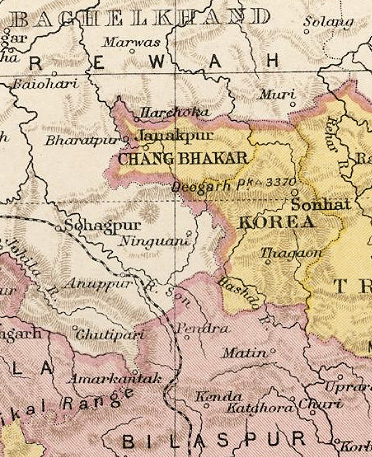 Changbhakar State in the Imperial Gazetteer of India | |||||||
| Capital | Bharatpur | ||||||
| Area | |||||||
• 1901 | 2,347 km2 (906 sq mi) | ||||||
| Population | |||||||
• 1901 | 19,548 | ||||||
| History | |||||||
• Established as a zamindari of Korea State | c. 1790 | ||||||
| 1948 | |||||||
| |||||||
| Today part of | Koriya district, Chhattisgarh | ||||||
| Columbia-Lippincott Gazetteer. (New York: Columbia University Press, 1952) p. 369 | |||||||
Changbhakar State, also known as Chang Bhakar, was one of the princely states of British Empire in India in the Chhattisgarh States Agency.[1] It included 117 villages and had an area of 2,330 square kilometres (899 sq mi) with a 1941 population of 21,266 people. Bharatpur was the capital of the princely state.
History
In 1790 Changbhakar zamindari or estate was carved out of Korea State. After the Anglo-Maratha war in the early nineteenth century, Changbhakar became a tributary state of British India. Changbhakar estate was recognized as a state in 1819 and was placed under the Chota Nagpur Tributary States in 1821. In October 1905, it was transferred and brought under the control of the Commissioner of Chhattisgarh division of Central Provinces. It acceded to the Union of India on 1 January 1948 and was placed under Surguja district of Central Provinces and Berar. Presently it is a Subdivision and a Tehsil of Koriya district of Chhattisgarh state.[2]
Rulers
The rulers were Rajputs of the Chauhan dynasty. They had been formerly addressed as 'Raja', but from 1865 they used the title of 'Bhaiya'.
- 1819 - 18.. Man Singh Deo
- 1848 - 1865 Janjit Singh Deo
- 1 Dec 1865 - 1897 Balabhadra Singh Deo (b. c.1825 - d. ... )
- 1897 - 1932 Mahabir Singh Deo (b. 1879 - d. 1932)
- 1932 - 1947 Krishna Pratap Singh Deo
- 1932 - 1946 ... -Regent
See also
References
- ^ "Princely State of Changbhakar". Princely States of India.
- ^ "Changbhakar (Princely State)". IndianRajputs.com.
External links
23°44′N 81°49′E / 23.733°N 81.817°E
This article related to a location in the Indian state of Chhattisgarh is a stub. You can help Wikipedia by expanding it. |