Ahiazu Mbaise: Difference between revisions
Appearance
Content deleted Content added
m Robot - Moving category Cities, towns and villages in Imo State to Populated places in Imo State per CFD at Wikipedia:Categories for discussion/Log/2010 May 28. |
m Scanned 1 urls; found 1 archives (1 in CiteWeb Templates; 1 in References). See User:DASHBot/Dead Links for settings, shutoff, info, questions. |
||
| Line 65: | Line 65: | ||
It has an area of 114 km² and a population of 170,902 at the 2006 census. |
It has an area of 114 km² and a population of 170,902 at the 2006 census. |
||
The [[postal code]] of the area is 463.<ref>{{cite web | title = Post Offices- with map of LGA | work = | publisher = NIPOST | url = http://www.nipost.gov.ng/PostCode.aspx | accessdate = 2009-10-20 }}</ref> |
The [[postal code]] of the area is 463.<ref>{{cite web | title = Post Offices- with map of LGA | work = | publisher = NIPOST | url = http://www.nipost.gov.ng/PostCode.aspx | accessdate = 2009-10-20 | archiveurl= http://web.archive.org/web/20091007011423/http://www.nipost.gov.ng/PostCode.aspx| archivedate= 7 October 2009 <!--DASHBot-->| deadurl= no}}</ref> |
||
==References== |
==References== |
||
Revision as of 20:13, 23 March 2012
Ahiazu Mbaise | |
|---|---|
| Country | |
| State | Imo State |
| Time zone | UTC+1 (WAT) |
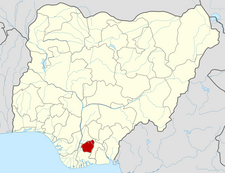
Ahiazu Mbaise is a Local Government Area of Imo State, Nigeria. Its headquarters are in the town of Afororu (or Afor Oru).
It has an area of 114 km² and a population of 170,902 at the 2006 census.
The postal code of the area is 463.[1]
References
- ^ "Post Offices- with map of LGA". NIPOST. Archived from the original on 7 October 2009. Retrieved 2009-10-20.
{{cite web}}: Unknown parameter|deadurl=ignored (|url-status=suggested) (help)
