File:Argentina orthographic.svg: Difference between revisions
Jump to navigation
Jump to search
Content deleted Content added
Adding image note: 與聯合王國屬地南喬治亞與南桑威奇群島爭議(南喬治亞島) Tag: Small image note |
|||||||||||||||
| (14 intermediate revisions by 9 users not shown) | |||||||||||||||
| Line 11: | Line 11: | ||||||||||||||
|date=2011-06-21 |
|date=2011-06-21 |
||||||||||||||
|source={{own}} with [http://www.naturalearthdata.com/ Natural Earth Data] |
|source={{own}} with [http://www.naturalearthdata.com/ Natural Earth Data] |
||||||||||||||
|author=[[User:Addicted04|Addicted04]] |
|author=[[User:Addicted04|Addicted04]] |
||||||||||||||
|other fields={{Igen|+|98|s=ggg}} |
|||||||||||||||
|permission= |
|||||||||||||||
|other_versions= |
|||||||||||||||
|other_fields= |
|||||||||||||||
}} |
}} |
||||||||||||||
| Line 25: | Line 23: | ||||||||||||||
{{self|cc-by-3.0}} |
{{self|cc-by-3.0}} |
||||||||||||||
| ⚫ | |||||||||||||||
[[Category:Uploaded with UploadWizard]] |
|||||||||||||||
{{ImageNote|id=2|x=263|y=354|w=15|h=10|dimx=550|dimy=550|style=2}} |
|||||||||||||||
| ⚫ | |||||||||||||||
阿根廷與[[:zh:聯合王國|聯合王國]]爭議領土[[:zh:福克蘭群島|福克蘭群島]] |
|||||||||||||||
{{ImageNoteEnd|id=2}} |
|||||||||||||||
{{ImageNote|id=3|x=247|y=397|w=80|h=110|dimx=550|dimy=550|style=2}} |
|||||||||||||||
不為國際社會所承認的[[:zh:阿根廷南極屬地|阿根廷南極屬地]] |
|||||||||||||||
{{ImageNoteEnd|id=3}} |
|||||||||||||||
{{ImageNote|id=4|x=328|y=372|w=11|h=12|dimx=550|dimy=550|style=2}} |
|||||||||||||||
與[[:zh:聯合王國|聯合王國]]屬地[[:zh:南喬治亞與南桑威奇群島|南喬治亞與南桑威奇群島]]爭議(南喬治亞島) |
|||||||||||||||
{{ImageNoteEnd|id=4}} |
|||||||||||||||
| mediainfo | |||||||||||||||
|---|---|---|---|---|---|---|---|---|---|---|---|---|---|---|---|
| caption / hi | caption / hi | ||||||||||||||
36000km long 22°S to 44°S | |||||||||||||||
| caption / tr | caption / tr | ||||||||||||||
Arjantin ortografik haritası | |||||||||||||||
| Property / inception | |||||||||||||||
21 June 2011
| |||||||||||||||
| Property / inception: 21 June 2011 / rank | |||||||||||||||
Normal rank | |||||||||||||||
| Property / source of file | |||||||||||||||
| Property / source of file: original creation by uploader / rank | |||||||||||||||
Normal rank | |||||||||||||||
| Property / copyright license | |||||||||||||||
| Property / copyright license: Creative Commons Attribution 3.0 Unported / rank | |||||||||||||||
Normal rank | |||||||||||||||
| Property / copyright status | |||||||||||||||
| Property / copyright status: copyrighted / rank | |||||||||||||||
Normal rank | |||||||||||||||
| Property / creator | |||||||||||||||
some value | |||||||||||||||
| Property / creator: some value / rank | |||||||||||||||
Normal rank | |||||||||||||||
| Property / creator: some value / qualifier | |||||||||||||||
author name string: Addicted04 | |||||||||||||||
| Property / creator: some value / qualifier | |||||||||||||||
| Property / creator: some value / qualifier | |||||||||||||||
| Property / media type | |||||||||||||||
image/svg+xml | |||||||||||||||
| Property / media type: image/svg+xml / rank | |||||||||||||||
Normal rank | |||||||||||||||
| Property / checksum | |||||||||||||||
4f137c299a67928851146a2bc597ad3353317154 | |||||||||||||||
| Property / checksum: 4f137c299a67928851146a2bc597ad3353317154 / rank | |||||||||||||||
Normal rank | |||||||||||||||
| Property / checksum: 4f137c299a67928851146a2bc597ad3353317154 / qualifier | |||||||||||||||
| Property / data size | |||||||||||||||
707,470 byte
| |||||||||||||||
| Property / data size: 707,470 byte / rank | |||||||||||||||
Normal rank | |||||||||||||||
| Property / height | |||||||||||||||
550 pixel
| |||||||||||||||
| Property / height: 550 pixel / rank | |||||||||||||||
Normal rank | |||||||||||||||
| Property / width | |||||||||||||||
550 pixel
| |||||||||||||||
| Property / width: 550 pixel / rank | |||||||||||||||
Normal rank | |||||||||||||||
Latest revision as of 14:31, 25 April 2024
Captions
Captions
Add a one-line explanation of what this file represents
Summary
[edit]| Description |
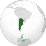
English: Orthographic map of Argentina centered on Buenos Aires
Official territory.
Claimed territories. Español: Mapa ortográfico de la Argentina centrado en Buenos Aires
Territorio oficial.
Territorios en disputa. |
| Date | |
| Source | Own work with Natural Earth Data |
| Author | Addicted04 |
| SVG development |
El único territorio que reclama son las malvinas, son los puntos verdes chiquitos, la antártida o el triangulo de abajo es argentino.


| Orthographic projections maps created by Ssolbergj |
|---|
| Orthographic projections maps created by Ssolbergj: |
Licensing
[edit]I, the copyright holder of this work, hereby publish it under the following license:
This file is licensed under the Creative Commons Attribution 3.0 Unported license.
- You are free:
- to share – to copy, distribute and transmit the work
- to remix – to adapt the work
- Under the following conditions:
- attribution – You must give appropriate credit, provide a link to the license, and indicate if changes were made. You may do so in any reasonable manner, but not in any way that suggests the licensor endorses you or your use.
File history
Click on a date/time to view the file as it appeared at that time.
| Date/Time | Thumbnail | Dimensions | User | Comment | |
|---|---|---|---|---|---|
| current | 16:48, 18 July 2013 | 550 × 550 (691 KB) | Montgomery (talk | contribs) | Reverted to version as of 22:50, 22 October 2011; COM:GL/M standars | |
| 16:08, 18 July 2013 | 550 × 550 (697 KB) | Cesardavidd (talk | contribs) | Reverted to version as of 20:32, 22 June 2011 | ||
| 22:50, 22 October 2011 | 550 × 550 (691 KB) | Addicted04 (talk | contribs) | claimed color | ||
| 22:39, 22 October 2011 | 550 × 550 (690 KB) | Addicted04 (talk | contribs) | claimed color | ||
| 20:32, 22 June 2011 | 550 × 550 (697 KB) | Addicted04 (talk | contribs) | latitude line | ||
| 21:08, 21 June 2011 | 550 × 550 (692 KB) | Addicted04 (talk | contribs) |
You cannot overwrite this file.
File usage on Commons
More than 100 pages use this file. The following list shows the first 100 pages that use this file only. A full list is available.
- Grey–green orthographic projections maps
- User:Heraldry/Projections
- User:Ssolbergj/orthographic
- File:ALBA (orthographic projection).png
- File:Africa (orthographic projection).svg
- File:African Union (orthographic projection).svg
- File:Almoravid map.svg
- File:America do Sul (orthographic projection).jpg
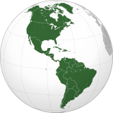
- File:Americas (orthographic projection).svg
- File:Andean Community (orthographic projection).svg
- File:Antarctica (orthographic projection).svg
- File:Antillas (orthographic projection).svg
- File:Arctic (orthographic projection).svg
- File:Argentina (orthographic projection).png
- File:Argentina (orthographic projection).svg
- File:Aridoamerica (orthographic projection).svg
- File:Armenia (orthographic projection).svg
- File:Asia (orthographic projection).svg
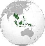
- File:Association of Southeast Asian Nations (orthographic projection).svg
- File:Australia-New Guinea (orthographic projection).svg
- File:Australia (orthographic projection).svg
- File:Australia map with outlying islands.svg
- File:Bhutan (orthographic projection).svg
- File:Brazil (orthographic projection).svg
- File:CECAFA-Map.svg
- File:Canada (orthographic projection).svg
- File:Cape Verde (orthographic projection).svg
- File:Captaincy General of Chile (orthographic projection).svg
- File:Central America (orthographic projection).svg
- File:Central Asia (orthographic projection).svg
- File:Chile (orthographic projection).svg
- File:Colombia (orthographic projection).svg
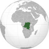
- File:Democratic Republic of the Congo (orthographic projection).svg
- File:Denmark (orthographic projection).svg
- File:Dominion of Pakistan & Indian Controlled Kashmir (orthographic projection).svg
- File:East Asia (orthographic projection).svg
- File:Ecuador (orthographic projection).svg
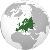
- File:Europe (orthographic projection).svg
- File:European Union (orthographic projection).svg
- File:Federal Republic of Central America (orthographic projection).svg
- File:First Brazilian Empire (orthographic projection).svg
- File:First Mexican Empire (orthographic projection).svg
- File:Georgia (orthographic projection).svg
- File:Germany (orthographic projection).svg
- File:Global European Union.svg
- File:Great Colombia (orthographic projection).svg
- File:Greater Middle East (orthographic projection).svg
- File:Haiti (orthographic projection).svg
- File:India (orthographic projection).svg
- File:Indonesia (orthographic projection).svg
- File:Iran (orthographic projection).svg
- File:Iraq (orthographic projection).svg
- File:Jamaica (orthographic projection).svg
- File:Japan (orthographic projection).svg
- File:Kazakhstan (orthographic projection).svg
- File:Latin America (orthographic projection).svg
- File:Lusophone America (orthographic projection).svg
- File:MERCOSUR (orthographic projection).svg
- File:Madagascar (orthographic projection).svg
- File:Maghreb (orthographic projection).svg
- File:Malaysia (orthographic projection).svg
- File:Mayan languages (orthographic projection).svg
- File:Mesoamerica (orthographic projection) with borders.svg
- File:Mexico (orthographic projection).svg
- File:Mexico and Central America (orthographic projection).svg
- File:Middle East (orthographic projection).svg
- File:Mongolia (orthographic projection).svg
- File:New Spain (orthographic projection).svg
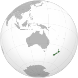
- File:New Zealand (orthographic projection).svg
- File:Nigeria (orthographic projection).svg
- File:North Africa (orthographic projection).svg
- File:North America (orthographic projection).svg
- File:North American Agreement (orthographic projection).svg
- File:North Korea (orthographic projection).svg
- File:Papua New Guinea (orthographic projection).svg
- File:Paraguay (orthographic projection).svg
- File:People's Republic of China (orthographic projection).svg
- File:Peru (orthographic projection).svg
- File:Peru–Bolivia Confederation (orthographic projection).svg
- File:Philippines (orthographic projection).svg
- File:Republic of Artsakh (orthographic projection).svg
- File:Republic of China (orthographic projection).svg
- File:Rio Group (orthographic projection).svg
- File:Roman Empire (orthographic projection).svg
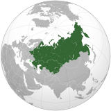
- File:Russian Federation (orthographic projection).svg
- File:Second Mexican Empire (orthographic projection).svg
- File:South Asia (orthographic projection) without national boundaries.svg
- File:South Korea (orthographic projection).svg
- File:Southern Europe (orthographic projection).svg
- File:Tawantinsuyu (orthographic projection).svg
- File:The Philippines and ASEAN (orthographic projection).svg
- File:Third Reich (orthographic projection).svg
- File:Tunisia (orthographic projection).svg
- File:Turkey (orthographic projection).svg
- File:Union of South American Nations (orthographic projection).svg
- File:Union of Soviet Socialist Republics (orthographic projection).svg
- File:United Provinces of Central America (orthographic projection).svg
- File:Venezuela (orthographic projection).svg
- File:Viceroyalty of Peru (orthographic projection).svg
- File:Viceroyalty of the Río de la Plata (orthographic projection).svg
View more links to this file.
File usage on other wikis
The following other wikis use this file:
- Usage on an.wikipedia.org
- Usage on ar.wikipedia.org
- Usage on as.wikipedia.org
- Usage on av.wikipedia.org
- Usage on awa.wikipedia.org
- Usage on ay.wikipedia.org
- Usage on azb.wikipedia.org
- Usage on bh.wikipedia.org
- Usage on bm.wikipedia.org
- Usage on bn.wikipedia.org
- Usage on bo.wikipedia.org
- Usage on bpy.wikipedia.org
- Usage on br.wikipedia.org
- Usage on bxr.wikipedia.org
- Usage on ca.wikipedia.org
- Usage on cbk-zam.wikipedia.org
- Usage on cdo.wikipedia.org
- Usage on ceb.wikipedia.org
- Usage on chr.wikipedia.org
- Usage on ch.wikipedia.org
- Usage on co.wikipedia.org
- Usage on crh.wikipedia.org
- Usage on cv.wikipedia.org
- Usage on de.wiktionary.org
- Usage on dsb.wikipedia.org
- Usage on dty.wikipedia.org
- Usage on ee.wikipedia.org
- Usage on en.wikipedia.org
- Usage on es.wikipedia.org
- Categoría:Provincia de Buenos Aires
- Categoría:Provincia de Catamarca
- Categoría:Provincia de Chaco
- Categoría:Provincia de Córdoba (Argentina)
- Categoría:Provincia de Corrientes
- Categoría:Provincia de Entre Ríos
- Categoría:Provincia de Formosa
- Categoría:Provincia de Jujuy
- Categoría:Provincia de La Pampa
- Categoría:Provincia de La Rioja (Argentina)
- Categoría:Provincia de Mendoza
- Categoría:Provincia de Río Negro
- Categoría:Provincia de Salta
View more global usage of this file.