
Gannett Peak, Wyoming
Prominence: 7078 ft, 2157 m | Elevation: 13,806 feet, 4208 meters |
True Isolation: 290.36 mi, 467.28 km |
| Subpeaks | Gannett Peak - South Peak (13,316 ft/4059 m)
Gooseneck Pinnacle (13,037 ft/3974 m)
| | Elevation Info | Summit: 13,806 feet (NAVD88 Vertical Datum)
Source/Method: Lidar
Lidar Data Set Info | | Latitude/Longitude (WGS84) | 43.18419, -109.65425 (Dec Deg)
43° 11' 3'' N, 109° 39' 15'' W (DMS)
609359 E, 4782171 N, Zone 12 (UTM) | | Map Source | US Geological Survey (1:24,000)
Sheet: Gannett Peak (O43109b6)
| | Country | United States | | State/Province | Wyoming (Highest Point) | | County/Second Level Region | Fremont (Highest Point)
Sublette (Highest Point) | Links
Search Engines - search the web for "Gannett Peak":
Wikipedia Search
Microsoft Bing Search
Google Search
Yahoo Search
Other Web Sites
Gannett Peak at SummitPost
Gannett Peak at ListsOfJohn
Gannett Peak at Mountain-Forecast.com
Gannett Peak at Summits on the Air (Amateur Radio)
Gannett Peak at Hikr.org
Gannett Peak at USGS-GNIS
CoHP.org Trip Report for Fremont, WY by Scott Casterlin
CoHP.org Trip Report for Fremont, WY by Adam Helman
CoHP.org Trip Report for Fremont, WY by Peter and Mary Green
Weather and Snow
National Weather Service Forecast
NOAA Snow Depth Map
Selected Guidebook(s) for this Peak:
 Select Peaks of Greater Yellowstone (Turiano) Select Peaks of Greater Yellowstone (Turiano)
Fifty State Summits, Guide with Maps to State Highpoints (Zumwalt)
Highpoints of the United States: A Guide to the Fifty State Summits (Holmes)
Highpoint Adventures: The Complete Guide to the 50 State Highpoints (Winger)
| Ascent Info
Total ascents/attempts logged by registered Peakbagger.com users: 465
Show all viewable ascents/attempts (Total: 441)
Selected Trip Reports - Click on linked Date for full report:
| Date | Climber | Type | GPS | TR Words | Link |
|---|
| 2023-07-07 | Landadio, Chris |  |  | TR-308 | | | (2023-07-04) | R, Bradley |  | | TR-3071 | | | 2022-07-15 | Busack, Rob | | | TR-19 | caltopo.com | | 2021-08-14 | Blunk, Collin | | | TR-2 | youtube.com | | 2021-07-22 | Blume, Walter | | | TR-1088 | | | 2020-07-04 | Super, Josh | | | TR-374 | | | 2019-08-15 | Grengs, Patrick | | | TR-382 | | | 2019-08-02 | Mondello, Harvest | | | TR-406 | | | 2019-07-23 | Weiland, Craig | | | | mountainflamingo.com | | 2019-07-23 | Gerlach, Greg | | | TR-302 | | | (2019-07-23) | Averill, William | | | TR-370 | | | 2019-07-18 | Quint, Michael | | | TR-367 | | | (2019-07-12) | Van Atta, Kyle | | | TR-577 | | | 2018-08-24 | Peterson, Rick | | | TR-703 | | | 2018-08-22 | Covill, Dave | | | TR-560 | | | 2018-07-08 | Christiansen, Mike | | | TR-639 | | | 2018-07-05 | Webb, Brian | | | TR-987 | | | 2018-06-30 | Foutz, Tracy | | | TR-900 | | | 2016-09-08 | Johnson, Lane | | | TR-1124 | | | 2016-07-26 | Giurgiulescu, Mihai | | | TR-851 | | | 2016-07-21 | Smith, Mark | | | TR-521 | | | 2015-09-01 | Musser, William | | | TR-5371 | | | 2014-07-27 | Still, Ben | | | TR-276 | facebook.com | | 2014-07-27 | Scott, Tye | | | TR-1338 | | | 2013-07-28 | Roots, Roger | | | TR-1358 | | | 2012-07-30 | Woodall, Rob | | | TR-2025 | peakbagger.com | | (2012-07-03) | Blume, Walter | | | TR-327 | | | 2003-08-21 | Lostracco, Ben | | | TR-873 | | | 1994-08-01 | Slayden, Greg | | | TR-2773 | | | (1992-09-03) | Slayden, Greg | | | TR-7190 | |
| Peak Lists that contain Gannett Peak
Contiguous 48 U.S. State High Points (Rank #4)
U.S. State High Points (Rank #5)
United States State/Territory High Points (Rank #5)
USA Lower 48 Range3 High Points (Rank #5)
Triple Crown CoHPs (Rank #3)
USA Lower 48 Peaks with 100 miles of Isolation (Rank #9)
5000 foot Prominence CoHPs - 48 States (Rank #8)
Fred Beckey's Great Peaks of the Continent (Rank #12)
USA Lower 48 Peaks with 5000 feet of Prominence (Rank #15)
Most Prominent Peaks of the U.S. States (Rank #8)
EPIC List - States of the USA (Rank #5)
Most Isolated Peaks of the U.S. States (Rank #10)
5000 foot Prominence CoHPs (Rank #13)
Combined USA-Canada-Mexico State/Province High Points (Rank #13)
USA Lower 48 Top 100 Peaks by Prominence (Rank #15)
U.S. County High Points over 13,000 feet - 48 States (Rank #29)
Apex (Toughest) CoHPs (Rank #4)
United States Peaks with 100 miles of Isolation (Rank #15)
USA Peaks with 6000 feet of Prominence (Rank #39)
Fifty Highest CoHPs in Lower 48 (Rank #25)
Greater Yellowstone Range High Points (Rank #1)
Wyoming County High Points (Rank #1)
Wyoming County Prominence Peaks (Rank #1)
Wyoming Peaks with 25 Miles of Isolation (Rank #1)
Wyoming Wilderness High Points (Rank #1)
Wyoming Peaks with 2000 feet of Prominence (Rank #1)
Wyoming 13,000-foot Peaks (Rank #1)
Select Peaks of Greater Yellowstone (Rank #1)
Wyoming Peaks with 1000 feet of Prominence (Rank #1)
(Peak is on over 20 lists; Not all shown here.)
| Nearby Peak Searches:
Radius Search - Nearest Peaks to Gannett Peak
Elevation Ladder from Gannett Peak
Prominence Ladder from Gannett Peak
| Description
The snowy crest of Gannett Peak rises in the heart of the most rugged and glaciated mountainscape in the American Rockies, dominating the northern Wind River Range. Those enamored of the famous and showy Grand Teton often begrudge Gannett its status at Wyoming's apex, muttering about the mere 34 feet separating the summit elevations. But anyone who has ventured into the remote "Winds" on an expedition to Gannett will come away with full respect for this fine and deserving state highpoint.
Gannett is commonly considered one of the toughest of the US State highpoints to attain, along with Granite Peak in Montana, Mount Rainier in Washington, and, of course, Denali. A combination of long approach hikes, steep snow/ice, and challenging rock scrambling or climbing make this a peak not for beginners or casual climbers.
Climbing Notes
Like many big mountains, Gannett Peak has many routes. Four of the most common are:
- From the town of Dubois and Trail Lakes Ranch, the Glacier Trail goes up and down for 20 miles or so before reaching the base of the Dinwoody Glacier. Here you climb the Gooseneck Ridge and Gooseneck Gully (steep ice or snow) to gain the summit ridge. This is probably considered the "standard" route.
- From the town of Pinedale and the Elkhart Park Trailhead, you can approach from the southwest, passing Island Lake and camping in Titcomb Basin. Main drawback to this route is that on summit day you must climb up and over Dinwoody Pass at the crest of the range before climbing Gannett itself by the Gooseneck route, making for a very long and hard day.
- You can cut off a large distance on the Glacier Trail by using the Ink Wells Trail. But the main issue here is that Ink Wells trailhead is on the Wind River Indian Reservation and the tribe will charge you a large sum (usually over $150) for use of their land. It can be a hassle to get the permit and transportation arranged for this option.
- The west face route may be the shortest in distance and elevation gain, but it requires some bushwhacking and it has the most rugged rock climbing of any of these four routes. The start is at the Green River Lakes trailhead.
Any one of these routes will be a three to five day expedition for most teams. You will need to bring rope, ice axe, crampons, and protection for rock and ice. |
Other Photos

The bergschrund (with 2 snow bridges still intact) protecting the final snow climb ascent up the steeper section of glacier next to Gooseneck Pinnacle (on the left) (2015-09-01). Photo by William Musser.
Click here for larger-size photo. |
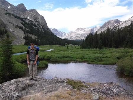
Taken about 18 miles from the trailhead. We think this is the first view you get of Gannett. We believe it can be seen in the right background with the snow on the summit (2016-07-21). Photo by Austin D. Smith.
Click here for larger-size photo. |
This page has been served 155764 times since 2004-11-01.
|