Who What Where WhenREMOVEWHATShow More |
REFINE
Search Results: All Fields similar to 'Massachusetts' and Where equal to 'Massachusetts'Author
Blaeu, Joan, 1596-1673
Full Title
Nova Belgica Et Anglia Nova
List No
15664.024
Note
20 Milliaria Germanica communia = 4.6 cm
Author
Blaeu, Joan, 1596-1673
Full Title
Nova Belgica Et Anglia Nova
List No
10017.643
Note
20 Milliaria Germanica communia = 4.6 cm
Author
Goos, Pieter, 1616-1675
Full Title
Pas caerte van Nieu Nederlandt en de Engelsche Virginies.
List No
12179.040
Author
[Bowen, Emanuel, Gibson, John]
Full Title
New England. (to accompany) Atlas Minimus or a New Set of Pocket Maps of the Several Empires, Kingdoms and States of the Known World, with Historical Extracts relative to each. Drawn and Engraved by J. Gibson from the Best Authorities, Revis'd, Corrected and Improv'd by Eman: Bowen Geographer to His Majesty.
List No
0300.044
Note
First edition. The "Historical Extracts" are short bits of text printed on the maps giving relevant geographical information. A revised edition was published in London in 1792. In 1759, another edition was published adding separate geographical descriptions and correcting some of the maps (see our copy). The Philadelphia 1798 edition by Mathew Carey incorporates the 1759 edition text word for word (excepting the maps of United States which Carey omits in favor of his pocket atlas of the U.S.). Gibson and Bowen made the four sheet map of North America (Stevens 49), and Gibson made the four sheet map of America (Stevens 3).
Author
Jefferys, Thomas
Full Title
A Map of the most Inhabited part of New England, containing the Provinces of Massachusetts Bay and New Hampshire, with the Colonies of Conecticut And Rhode Island, Divided into Counties and Townships: The Whole composed from Actual Surveys and its Situation adjusted by Astronomical Observations. (with) A Plan of the Town of Boston. November 29th 1774. Published according to Act by Thos. Jefferys Geographer to His Royal highness the Prince of Wales near Charing Cross. (Northern section)
List No
0346.017
Note
Northern part of map in two sheets. In outline color except for section to the west of the Connecticut River, which is in yellow.
Author
Jefferys, Thomas
Full Title
A Map of the most Inhabited part of New England, containing the Provinces of Massachusetts Bay and New Hampshire, with the Colonies of Conecticut And Rhode Island, Divided into Counties and Townships: The Whole composed from Actual Surveys and its Situation adjusted by Astronomical Observations. (with) A Plan of Boston Harbor from an Accurate Survey. November 29th 1774. Published according to Act by Thos. Jefferys Geographer to His Royal highness the Prince of Wales near Charing Cross. (Southern section)
List No
0346.018
Note
Southern part of map in two sheets. In outline color. Cartouche includes large drawing of the pilgrims landing at Plymouth Rock.
Author
[Sartine, Antoine, Depot de la Marine]
Full Title
Carte Particulière du Havre de Boston
List No
15933.018
Author
Morse, Jedidiah
Full Title
A Map of Massachusetts from the best Authorities. I. Mutlow Sc. 6 James St. Covt. Gardn. Published July 8, 1794 by I. Stockdale, Piccadilly.
List No
0632.008
Note
Without color.
Author
Scott, Joseph
Full Title
Massachusetts.
List No
0887.009
Note
Uncolored.
Author
[Carey, Mathew, Lewis, Samuel]
Full Title
The State of Massachusetts, Compiled from the best Authorities By Samuel Lewis. (above neat line) Engraved for Carey's American Edition of Guthries Geography improved by J.T. Scott.
List No
2542.005
Note
Uncolored.
Author
Carey, Mathew
Full Title
The State of Massachusetts. Compiled from the best Authorities By Samuel Lewis. Engraved for Carey's American Edition of Guthrie's Geography improved by J.T. Scott.
List No
2931.029
Note
Uncolored.
Author
[Reid, John, Winterbotham, W.]
Full Title
The State of Massachusetts, from the best Information 1796. Published by J. Reid, New York.
List No
0845.006
Note
Uncolored.
Author
Carey, Mathew
Full Title
The State of Massachusetts. Compiled from the best Authorities By Samuel Lewis. Engraved for Carey's American Edition of Guthrie's Geography improved by J.T. Scott.
List No
2862.028
Note
Uncolored.
Author
Carey, Mathew
Full Title
Massachusetts. W. Barker sculp.
List No
4865.005
Note
Uncolored.
Author
Carleton, Osgood
Full Title
(Covers to) Map Of Massachusetts Proper Compiled from Actual Surveys, made by Order of the General Court, and under the inspection of Agents of their appointment, By Osgood Carleton. Engraved by Joseph Callender and Samuel Hill, Boston, 1801. Vignette Drawn by G. Graham.
List No
2258A
Author
Carleton, Osgood
Full Title
Map Of Massachusetts Proper Compiled from Actual Surveys, made by Order of the General Court, and under the inspection of Agents of their appointment, By Osgood Carleton. Engraved by Joseph Callender and Samuel Hill, Boston, 1801. Vignette Drawn by G. Graham.
List No
2258.001
Note
Engraved by Joseph Callender and Samuel Hill. Second map of Massachusetts by Carleton (1st was 1798), reengraved from the plates of the first issue, and the first official state map (the first edition was rejected by the legislature). With outline and full color. Map is dissected into 32 sections and mounted on linen. Folds into original black cardboard slip case 21x16 with a red leather label on the spine reading "Map Of Mass." in gilt.
Author
Luffman, John, 1756-1846
Full Title
Boston. Engraved for Luffman's Select plans. Engrav'd & Publish'd March 1.1802, by J. Luffman. London.
List No
13189.156
Note
Hand colored city map. Shows Boston Harbor, small islands, and towns. Prime meridian is London. Includes text at the foot of map.
Author
Lewis, Samuel
Full Title
Massachusetts. Drawn by S. Lewis. Tanner sc. (Published by John Conrad & Co., Philadelphia. 1804)
List No
2436.037
Note
Engraved map, uncolored. Relief shown by hachures. Prime meridians: London and Philadelphia.
Author
Marshall, John
Full Title
Carte des Provinces Septles. des Etats-Unis. (1807)
List No
0462.001
Note
Fold-out map. Relief shown by sketches. Meridian Paris. Engraved.
Author
Marshall, John
Full Title
Boston et Ses Environs. (1807)
List No
0462.004
Note
Folded map. Relief shown by hachures. Vegetation and structures shown. Engraved.
Author
Marshall, John
Full Title
Boston and Its Environs. Engraved for Washington's Life. Plate I. Engd. by F. Vallance. Philada. Published by C.P. Wayne. 1806.
List No
2559.001
Note
Engraved. Folded map. Relief shown with hachures.
Author
Carey, Mathew
Full Title
The State of Massachusetts, Compiled from the best Authorities By Samuel Lewis. Engraved for Carey's American Edition of Guthrie's Geography Improved by J.T. Scott.
List No
4863.028
Note
Uncolored except for some islands and scale.
Author
Lewis, Samuel
Full Title
Massachusetts. Drawn by S. Lewis. (Boston: Published by Thomas & Andrews. 1812)
List No
0028.032
Note
Engraved map, uncolored. Relief shown by hachures. Prime meridians: London and Philadelphia.
Author
Carey, Mathew
Full Title
The State of Massachusetts.
List No
4577.009
Note
State in outline color by county.
Author
Lucas, Fielding Jr.
Full Title
Massachusetts. 11. H.S. Tanner, sc. (1816)
List No
4534.011
Note
Engraved, hand colored. Counties shown. Relief shown with hachures. Meridian Philadelphia.
Author
[Carey, Mathew, Warner, Benjamin]
Full Title
Massachusetts. (Engraved by) W. Barker, sculp.
List No
4864.014
Note
Prime meridians are from London and Philadelphia. Relief shown pictorially.
Author
Carey, Mathew
Full Title
The State of Massachusetts.
List No
2721.014
Note
State in outline color by county. Relief shown by hachures. Prime meridians London and Philadelphia.
Author
Baker, Harriet E.
Full Title
Massachusetts. (to accompany) Harriet E. Baker's Book of Penmanship & Map. At Mr. Dunham's School Windsor Vermont March 31, 1819.
List No
8307.024
Note
Outline color map by county. Showing cities and towns, and rivers. Relief shown by hachures.
Author
[Carey, H. C., Lea, I.]
Full Title
Geographical, Historical, And Statistical Map Of Massachusetts. Massachusetts. No. 12. Drawn by F. Lucas. J. Yeager Sculp.
List No
0122.007
Note
In full color by county surrounded by text.
Author
Lucas, Fielding Jr.
Full Title
Massachusetts. Drawn & Published by F. Lucas Jr., Baltimore. (1822)
List No
4866.035
Note
Engraved. Colored by county. Meridian Washington. Relief shown by sketches.
Author
Henshaw, Frances A.
Full Title
Massachusetts.
List No
2501.004
Note
In outline color.
Author
Henshaw, Frances A.
Full Title
(Description of) Massachusetts.
List No
2501F
Note
Text discusses the viable crops, the founding of the Phillips Academy in Andover and Harvard in Cambridge.
Author
Lucas, Fielding Jr.
Full Title
Massachusetts. Drawn & Published by F. Lucas Jr. Baltimore.
List No
4584.048
Note
Full color by county.
Full Title
Massachusetts, Rhode-Island and Connecticut. (with) Boston and its vicinity. N. & S.S. Jocelyn Sc. (New-Haven: N. & S.S. Jocelyn. 1823)
List No
4869.003
Note
Engraved map with inset and facing index page. Outline hand color. Relief shown by hachures. Prime meridians: Washington and Greenwich.
Author
Finley, Anthony
Full Title
Massachusetts. Young & Delleker Sc. Published by A. Finley Philada.
List No
2680.013
Author
Melish, John
Full Title
Sketch of the Action on the Heights of Charlestown (Boston), June 17th 1775, between His Majesty's Troops, under the command of Genl. Howe, and a large body of American Rebels. Copied by I.A. Chapman, from an original Sketch, taken by Henry De Berniere of the 14th Regiment of Infantry, now in the hands of J. Cist Esq. Engraved by Kneass, Young & Co. for the Analeche Magazine. Published by M. Thomas Philada. (1824)
List No
2803.026
Note
Engraved. Detailed battle references keyed to the map. Relief shown by wavy hachures. Swamps, breastworks, structures, roads, and troop positions shown.
Author
Lucas, Fielding Jr.
Full Title
(Covers to) Massachusetts. Drawn and Published by F. Lucas Jr. Baltimore.
List No
4946.001
Note
Lucas pocket maps are rarely seen. This Massachusetts pocket map is undated, but conforms to the (1824) edition atlas map. Full color by county. The brown leather covers 11.5x7.5 are gold stamped: "Massachusetts Published By F. Lucas Jr. Baltimore." Prime meridian is Washington D.C.
Author
Lucas, Fielding Jr.
Full Title
Massachusetts. Drawn and Published by F. Lucas Jr. Baltimore.
List No
4946.002
Note
Lucas pocket maps are rarely seen. This Massachusetts pocket map is undated, but conforms to the (1824) edition atlas map. Full color by county. The brown leather covers 11.5x7.5 are gold stamped: "Massachusetts Published By F. Lucas Jr. Baltimore." Prime meridian is Washington D.C.
Full Title
Carte geographique, statistique et historique de Massachusetts. Massachusetts. Fonderie et Imprimerie de J. Carez. (1825)
List No
0102.012
Note
Hand colored engraved map. Relief shown by hachures. Text and tables at sides and bottom. Prime meridians: Washington and Paris.
Author
Finley, Anthony
Full Title
Map of Massachusetts Connecticut And Rhode Island Constructed from the Latest Authorities. 1825. Drawn by D.H. Vance. Engraved by J.H. Young. Published by A. Finley Philada. 1825.
List No
0278.004
Note
In full color by county. Statistical table compares the populations of the counties in 1810 and 1820. Square mileage for each state included.
Author
DeSilver, Robert
Full Title
(Covers to) The State of Massachusetts.
List No
0240.001
Note
Reissue of M. Carey 1818 edition General Atlas. Map is folded into red stamped card covers 13x7 with "Massachusets" misspelled in gilt. This is the same coloring and watermark as the six DeSilver maps issued as separates (see Pennsylvania). No changes from the 1818 Carey plate.
Author
DeSilver, Robert
Full Title
The State of Massachusetts.
List No
0240.002
Note
Outline color map. Relief shown by hachures. Prime meridians are Philadelphia and London.
Author
Finley, Anthony
Full Title
Map of Massachusetts, Connecticut, and Rhode Island, Constructed from the Latest Authorities.
List No
0279.008
Note
Date estimated.
Author
Finley, Anthony
Full Title
Map of Massachusetts, Connecticut, and Rhode Island Constructed from the Latest Authorities. Drawn by D.H. Vance. Published by A. Finley, Philada. Engraved by J.H. Young.
List No
0280.004
Note
Relief shown by hachures. Prime meridian Washington. Statistical table for each state.
Author
Finley, Anthony
Full Title
Massachusetts. Young & Delleker Sc. Published by A. Finley, Philada. (to accompany) A New General Atlas Comprising a Complete Set of Maps, representing the Grand Divisions Of The Globe ... Philadelphia: Published by Anthony Finley. 1827.
List No
0282.014
Note
Full color map on sheet 35x27. Relief shown pictorially. Prime meridians are Washington and Greenwich. Shows counties, major cities, roads and rivers.
Author
Morse, Sidney E. (Sidney Edwards), 1794-1871
Full Title
(Covers to) Massachusetts, Rhode-Island And Connecticut. On the Improved Plan of Sidney E. Morse, A.M. Entered ... second day of May, 1827, By Sidney E. Morse ... Connecticut. Published by N. & S.S. Jocelyn, New-Haven, Con. 1827. N. & S.S. Jocelyn Sc. (inset) Boston and its Vicinity.
List No
0639.001
Note
From Atlas of the U.S., 1823. Index sheet joined. This is very early for an indexed map in pocket form; folded into red stamped paper covers 10x6.5 with "Mass. R.I. & Con." in gilt.
Author
Morse, Sidney E. (Sidney Edwards), 1794-1871
Full Title
Massachusetts, Rhode-Island And Connecticut. On the Improved Plan of Sidney E. Morse, A.M. Entered ... second day of May, 1827, By Sidney E. Morse ... Connecticut. Published by N. & S.S. Jocelyn, New-Haven, Con. 1827. N. & S.S. Jocelyn Sc. (inset) Boston and its Vicinity.
List No
0639.002
Note
Outline color map. Includes Joined index sheet: On the improved plan of Sidney E. Morse, A.M. With explanation of the plan. Relief shown by hachures.
Author
Finley, Anthony
Full Title
Massachusetts. (Pocket Atlas Of The New England States And New York). (with 7 maps) Connecticut, New York. Maine. New Hampshire. Vermont. Massachusetts. Rhode Island. Published by A. Finley Philada. Young & Delleker Sc.
List No
4083.007
Note
Rare, tiny pocket atlas published by Finley in 1827 (dated by the appearance of Orleans County on the New York State map - which matches the 1827 General Atlas New York State map) and made up of the General Atlas maps, on thin paper, of Maine, Vermont, New Hampshire, Massachusetts, Rhode Island, Connecticut and New York. There is no title page, and the title "Pocket Atlas Of The New England States And New York" is stamped in gold on the front brown leather cover 8.5x5. Maps in full color. Not listed in any references. Prime meridians are Washington D.C. and Greenwich. Relief shown by hachures.
Author
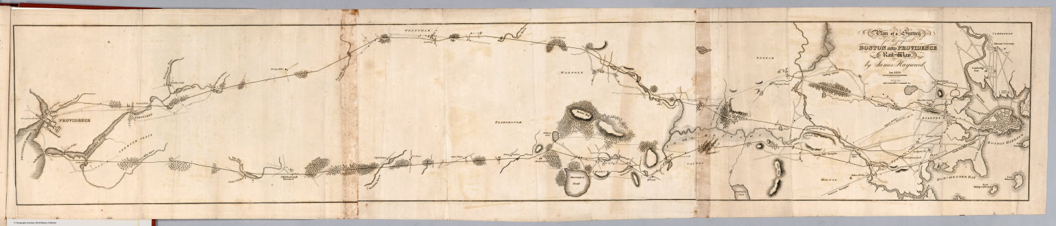
Hayward, James
Full Title
Plan of a survey for the proposed Boston and Providence rail way. By James Hayward. Jan. 1828. (engraved by) Annin & Smith. (to accompany) Report of the Board of Commissioners, of Internal Improvement in Relation to the Examination of Sundry Routes for a Railway from Boston to Providence.
List No
0324.006
Note
Map is uncolored. Shows 2 possible routes between Boston and Providence. Relief shown by hachures.
Author
Jocelyn, N. & S.S.
Full Title
(Covers to) Map Exhibiting the Farmington, & Hampshire & Hampden Canals, Together with the Line of their proposed continuation through the Valley of the Connecticut River, to Canada. Engraved and published by N. & S.S. Jocelyn. New Haven, 1828. Entered ... August 1st 1828 by N. & S.S. Jocelyn ... Connt. (inset) Profile of the Canals. Surveys furnished by Davis Hurd Esqr. Chief Engineer.
List No
3121.001
Note
Shows Connecticut River from its mouth to the Canadian border. A beautiful map, showing the canal proposed to run all the way to the Canadian border along the Connecticut River. The canal was built only to Northampton, Massachusetts. Much detail is shown of the areas on both sides of the river. Another issue from the same plate (but not emphasizing the canals in the title) is "An Improved Reference Map of the Valley of the Connecticut and Western Section of New England" published by Rustin Pierce and engraved by Jocelyn, 1828 (Thompson 80). Both maps credit "Surveys by Davis Hurd, Esq.. Chief Engineer." Thompson refers to this map as "quite rare"(p.31). Full color by county, folded into brown leather covers14x9 with "Farmington And Hampshire & Hampden Canals &c." stamped in gilt.
|