You are here

A National Weather Service graphical depiction of weather over the continental United States for Sunday, January 1, 2012 at 13UTC. A well-defined cold front is shown stretching from the Great Lakes to Texas. This image was downloaded through NOMADS.
The Service Records Retention System (SRRS) stores weather observations, summaries, forecasts, warnings, and advisories provided by the U.S. National Weather Service (NWS) for public use. SRSS products are legally mandated by Congress for archival at NCDC, and are retained for a five-year period. Customers often use SRRS records for accident investigations and litigations. Three broad categories of SRRS data exist: observations, forecasts, and graphics. Observations are typically text products while forecasts are both text and graphical. The graphics category of SRRS data contains images of surface analysis, standard layer upper air analyses, weather depictions, radar summaries, and ocean products. Coverage of these data is both global and regional. All categories of SRRS data are available through NCDC. SRRS graphic products are available for download through NOMADS.
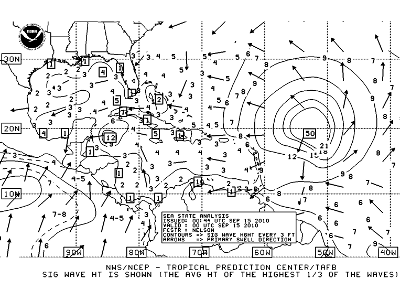
A National Weather Service graphical weather depiction of tropical weather in the North Atlantic on September 15, 2010 at 00:44UTC. This sea state analysis shows significant wave heights and the primary direction of the swells. Hurricane Igor, a category 4 hurricane at this time, is marked by concentric rings of wave heights in the middle of the Atlantic. This image was downloaded through NOMADS.