
Jet stream over Canada.

Jet streams flow from west to east in
the upper portion of the troposphere.
Jet streams are fast flowing, narrow
air current found in the atmospheres of some
planets. The main jet streams are located
near the
tropopause, the transition
between the
troposphere (where
temperature decreases with height) and the
stratosphere (where temperature increases with
height). The major jet streams on earth are westerly winds (flowing
west to east). Their paths typically have a
meandering shape; jet streams may start, stop, split
into two or more parts, combine into one stream, or flow in various
directions including the opposite direction of most of the
jet.
The strongest jet streams are the
polar jets, at
around above sea level, and the higher and somewhat weaker
subtropical jets at around .
The northern
hemisphere and the southern hemisphere
 each have both a polar jet and a subtropical
jet. The northern hemisphere polar jet is situated
over the middle to northern latitudes of North America, Europe,
and Asia, while the southern hemisphere polar
jet mostly circles Antarctica
each have both a polar jet and a subtropical
jet. The northern hemisphere polar jet is situated
over the middle to northern latitudes of North America, Europe,
and Asia, while the southern hemisphere polar
jet mostly circles Antarctica all year round.
Jet streams are caused by a combination of atmospheric heating (by
solar radiation and, on some planets
other than earth,
internal heat) and
the planet's
rotation on its axis.
They form near boundaries of adjacent air masses with significant
differences in
temperature, such as the
polar region and the warmer air to the
south.
Meteorologists use the location of the jet streams as an aid in
weather forecasting. The main
commercial relevance of the jet streams is in air travel, as flight
time can be dramatically affected by either flying with or against
a jet stream.
Clear-air
turbulence, a potential hazard to aircraft, often is found in a
jet stream's vicinity. One future benefit of jet streams could be
to power
airborne wind
turbines.
Other jets also exist. During the northern hemisphere summer,
easterly jets can form in tropical regions, typically in a region
where dry air encounters more humid air at high altitudes. Low
level jets also are typical of various regions such as the central
United States.
Discovery
Jet streams may have been first detected in the 1920s by Japanese
meteorologist
Wasaburo Ooishi.
From a
site near Mount
Fuji , he tracked pilot balloons, also known as pibals
(balloons used to determine upper level winds), as they rose into
the atmosphere.
, he tracked pilot balloons, also known as pibals
(balloons used to determine upper level winds), as they rose into
the atmosphere. Ooishi's work largely went unnoticed outside
of Japan. American pilot
Wiley Post, the
first man to fly around the world solo in 1933, is often given some
credit for discovery of jet streams. Post invented a pressurized
suit that let him fly above . In the year before his death, Post
made several attempts at a high-altitude transcontinental flight,
and noticed that at times his ground speed greatly exceeded his air
speed.German meteorologist H. Seilkopf is credited with coining the
term "jet stream" (Strahlströmung) in a 1939 paper. Many sources
credit real understanding of the nature of jet streams to regular
and repeated flight-path traversals during
World War II. Flyers consistently noticed
westerly tailwinds in excess of 100 mph in flights, for example,
from the US to the UK.
Description

250 px

250 px
Polar jet streams are typically located near the 250
hPa pressure level, or to above
sea level, while the weaker subtropical jet
streams are much higher, between and above sea level. In each
hemisphere, both upper-level jet streams form near breaks in the
tropopause, which is at a higher altitude near the equator than it
is over the poles, with large changes in its height occurring near
the location of the jet stream. The northern hemisphere polar jet
stream is most commonly found between latitudes
30°N and
60°N, while the northern subtropical jet
stream located close to latitude 30°N. The upper level jet stream
is said to "follow the sun" as it moves northward during the warm
season, or late spring and summer, and southward during the cold
season, or autumn and winter.
The width of a jet stream is typically a few hundred miles and its
vertical thickness often less than three miles.

Meanders of the northern hemisphere's
polar jet stream developing (a), (b); then finally detaching a
"drop" of cold air (c).
Orange: warmer masses of air; pink: jet stream.
Jet streams are typically continuous over long distances, but
discontinuities are common. The path of the jet typically has a
meandering shape, and these meanders themselves propagate east, at
lower speeds than that of the actual
wind
within the flow. Each large meander, or wave, within the jet stream
is known as a
Rossby wave. Rossby waves
are caused by changes in the
Coriolis
effect with latitude, and propagate westward with respect to
the flow in which they are embedded, which slows down the eastward
migration of upper level troughs and ridges across the globe when
compared to their embedded shortwave troughs. Shortwave troughs are
smaller packets of upper level energy, on the scale of to long,
which move through the flow pattern around large scale, or
longwave, ridges and troughs within Rossby waves. Jet streams can
split into two due to the formation of an upper-level closed low,
which diverts a portion of the jet stream under its base, while the
remainder of the jet moves by to its north.
The wind speeds vary according to the temperature
gradient, exceeding , although speeds of over have
been measured. Meteorologists now understand that the path of jet
streams steers cyclonic storm systems at lower levels in the
atmosphere, and so knowledge of their course has become an
important part of weather forecasting.
For example, in 2007,
Britain experienced
severe flooding as a result of the polar jet staying south for the
summer.
experienced
severe flooding as a result of the polar jet staying south for the
summer.
The polar and subtropical jets merge at some locations and times,
while at other times they are well separated.
Cause

Highly idealised depiction of the
global circulation.
The upper-level jets tend to flow latitudinally along the cell
boundaries.
In general, winds are strongest under the tropopause (except during
tornadoes,
hurricanes or other anomalous situations). If two
air masses of different temperatures or densities meet, the
resulting pressure difference caused by the density difference
(which causes wind) is highest within the transition zone. The wind
does not flow directly from the hot to the cold area, but is
deflected by the Coriolis effect and flows along the boundary of
the two air masses.
All these facts are consequences of the
thermal wind relation. The balance of forces on
an atmospheric parcel in the vertical direction is primarily
between the pressure gradient and the force of gravity, a balance
referred to as
hydrostatic. In the
horizontal, the dominant balance outside of the tropics is between
the Coriolis effect and the pressure gradient, a balance referred
to as
geostrophic. Given both
hydrostatic and geostrophic balance, one can derive the thermal
wind relation: the vertical derivative of the horizontal wind is
proportional to the horizontal temperature gradient. The sense of
the relation is such that temperatures decreasing polewards implies
that winds develop a larger eastward component as one moves
upwards. Therefore, the strong eastward moving jet streams are in
part a simple consequence of the fact that the equator is warmer
than the north and south poles.
The thermal wind relation does not immediately provide an
explanation for why the winds are organized in tight jets, rather
than distributed more broadly over the hemisphere. There are two
factors that contribute to this sharpness of the jets. One is the
tendency for developing cyclonic disturbances in midlatitudes to
form
fronts — sharp
localized gradients in temperature.
Polar jet
The polar jet stream can be thought of as the result of this
frontogenesis process in
midlatitudes.
Subtropical jet
The subtropical jet forms at the poleward limit of the tropical
Hadley cell and to first order this
circulation is symmetric with respect to longitude. Tropical air
rises to the
tropopause, mainly because
of thunderstorm systems in the intertropical convergence zone, and
moves poleward before sinking; this is the Hadley circulation. As
it does so it tends to conserve angular momentum, since friction is
slight above the ground. In the northern hemisphere motions are
deflected to the right by the
Coriolis
force, which for poleward (northward) moving air implies an
increased eastward component of the winds.. Around 30 degrees from
the equator the jet wind speeds have become strong enough that were
the jet to extend further polewards the increased windspeed would
be unstable; thus the jet is limited.
Other planets
Jupiter's atmosphere has multiple jet
streams, forming the familiar banded color structure, caused by
internal heating. The factors that control the number of jet
streams in a planetary atmosphere is an active area of research in
dynamical meteorology. In models, as one increases the planetary
radius, holding all other parameters fixed, the number of jet
streams increases.
Uses
Aviation
The location of the jet stream is extremely important for aviation.
Commercial use of the jet stream began on November 18, 1952, when
Pan Am flew from Tokyo to Honolulu at an
altitude of . It cut the trip time by over one-third, from 18 to
11.5 hours. Not only does it cut time off the flight, it also nets
fuel savings for the airline industry. Within North America, the
time needed to fly east across the
continent can be decreased by about 30
minutes if an
airplane can fly with the jet stream, or
increased by more than that amount if it must fly west against
it.
Associated with jet streams is a phenomenon known as
clear air turbulence (CAT), caused by
vertical and horizontal
windshear
connected to the jet streams. The CAT is strongest on the cold
air side of the jet, next to and just underneath
the axis of the jet. Clear air turbulence can be hazardous to
aircraft, and has caused fatal accidents, such as
United Airlines Flight 826
.
Future power generation
Scientists are investigating ways to harness the wind energy within
the jet stream. According to one estimate, of the potential wind
energy in the jet stream, only 1 percent would be needed to
meet the world's current energy needs. The required technology
would reportedly take 10–20 years to develop.
Unpowered aerial attack
Towards
the end of World War II the Japanese
fire balloon was designed as a cheap
weapon intended to make use of the jet stream over the Pacific Ocean to reach the west coast of Canada
 and the
United
States
and the
United
States .
. They were relatively ineffective as weapons
and were used in one of the few
attacks on North
America during World War II, causing six deaths and a small
amount of damage.
Changes due to climate cycles
Effects of ENSO
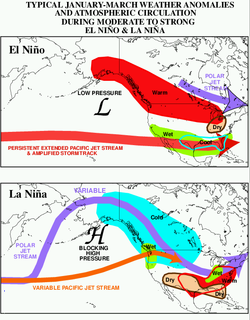
250 px
The changing of the normal location of upper-level jet streams can
be anticipated during phases of the
El Niño-Southern
Oscillation (ENSO), which leads to consequences
precipitation-wise and temperature-wise across North America,
affects
tropical cyclone
development across the eastern Pacific and Atlantic basins.
Combined with the
Pacific
Decadal Oscillation, ENSO can also impact cold season rainfall
in Europe. Changes in ENSO also change the location of the jet
stream over South America, which partially effects precipitation
distribution over the continent.
El Niño
During
El Niño events, increased
precipitation is expected in California due to a more southerly,
zonal, storm track. During the El Niño portion of ENSO, increased
precipitation falls along the Gulf coast and Southeast due to a
stronger than normal, and more southerly, polar jet stream.
Snowfall is greater than average across the southern Rockies and
Sierra Nevada mountain range, and is well-below normal across the
Upper Midwest and Great Lakes states. The northern tier of the
lower 48 exhibits above normal temperatures during the fall and
winter, while the Gulf coast experiences below normal temperatures
during the winter season.
The subtropical jet stream across the deep
tropics of the Northern
Hemisphere is enhanced due to increased convection in the
equatorial Pacific, which decreases tropical cyclogenesis within the
Atlantic tropics below what is normal, and increases tropical
cyclone activity across the eastern Pacific. In the Southern
Hemisphere, the subtropical jet stream is displaced equatorward, or
north, of its normal position, which diverts frontal systems and
thunderstorm complexes from reaching central portions of the
continent.
La Niña
Across North America during
La Niña,
increased precipitation is diverted into the
Pacific Northwest due to a more northerly
storm track and jet stream. The storm track shifts far enough
northward to bring wetter than normal conditions (in the form of
increased snowfall) to the Midwestern states, as well as hot and
dry summers. Snowfall is above normal across the Pacific Northwest
and western Great Lakes. Across the North Atlantic, the jet stream
is stronger than normal, which directs stronger systems with
increased precipitation towards Europe.
The Dust Bowl
Evidence suggests the jet stream was at least partially responsible
for the widespread drought conditions during the 1930s
Dust Bowl in the Midwest United States.
Normally,
the jet stream flows east over the Gulf of Mexico and turns northward pulling up moisture and dumping
rain onto the Great Plains
and turns northward pulling up moisture and dumping
rain onto the Great Plains .
. During the Dust Bowl, the jet stream
weakened and changed course traveling farther south than normal.
This starved the Great Plains and other areas of the Midwest of
precious rain creating dusty conditions.
Longer-term climatic changes
During
2007, 2008, 2009 the Jet Stream has been at an abnormally low
latitude across the UK, lying closer to the English
Channel , around 50°N rather than its more usual north of
Scotland latitude of around 60°N. However, between 1979
and 2001, it has been found that the position of the jet stream has
been moving northward at a rate of per year across the Northern
Hemisphere.
, around 50°N rather than its more usual north of
Scotland latitude of around 60°N. However, between 1979
and 2001, it has been found that the position of the jet stream has
been moving northward at a rate of per year across the Northern
Hemisphere. Across North America, this type of change
could lead to drier conditions across the southern tier of the
United States and more frequent and more intense
tropical cyclones in the tropics.
A similar
slow poleward drift was found when studying the Southern
Hemisphere jet stream over the same time frame.
Other upper-level jets
Polar night jet
The polar-night jet stream forms only during the winter months
(i.e.
polar nights) of the year in their
respective hemispheres at around 60° latitude, but at a greater
height than the polar jet, of about 80,000 feet. During these dark
months the air high over the poles becomes much colder than the air
over the Equator. This difference in temperature gives rise to
extreme air-pressure differences in the stratosphere which, when
combined with the Coriolis effect, create the polar night jets
which race eastward at altitudes of about 30 miles. Inside the
polar night jet is the
polar vortex.
The warmer air can only move along the edge of the polar vortex,
but not enter it. Within the vortex, the cold polar air becomes
cooler and cooler with neither warmer air from lower latitudes nor
energy from the sun during the
polar
night.
Low level jets
There are wind maxima at lower levels of the atmosphere that are
also referred to as jets.
Barrier jet
A barrier jet in the low levels forms just upstream of mountain
chains, with the mountains forcing the jet to be oriented parallel
to the mountains. The mountain barrier increases the strength of
the low level wind by 45 percent. A southerly low-level jet in
the Great Plains helps fuel overnight thunderstorm activity during
the warm season, normally in the form of
mesoscale convective systems
which form during the overnight hours.
A similar phenomenon
develops across Australia, which pulls moisture poleward from the
Coral
Sea towards cut-off lows which form mainly across
southwestern portions of the continent.
towards cut-off lows which form mainly across
southwestern portions of the continent.
Africa
The
mid-level African easterly jet
which occurs during the Northern Hemisphere summer between 10°N and
20°N above West Africa, and the nocturnal poleward low-level jet in
the Great
Plains. The low-level easterly African jet stream
is considered to play a crucial role in the southwest
monsoon of Africa, and helps form the
tropical waves which march across the tropical
Atlantic and eastern Pacific oceans during the warm season. The
formation of the
thermal low over
northern Africa leads to a low-level westerly jet stream from June
into October.
See also
References
- United States Department of
Energy June 26, 2002. Ask a Scientist. Retrieved on 2008-05-05.
- University of Illinois. Jet Stream. Retrieved on 2008-05-04.
- John M. Lewis. Ooishi's Observation: Viewed in the Context of Jet
Stream Discovery. Retrieved on 2008-05-08.
- Martin Brenner. Pilot
Balloon Resources. Retrieved on 2008-05-13.
- Acepilots.com. Wiley Post. Retrieved on 2008-05-08.
- John M. Lewis: Clarifying the Dynamics of the
General Circulation: Phillips’s 1956 Experiment from: Bulletin
of the American Meterological Society, Vol. 79, No. 1, January
1988
- BBC. Weather Basics - Jet Streams. Retrieved on
2008-05-08.
- David R. Cook Jet Stream Behavior. Retrieved on 2008-05-08.
- B. Geerts and E. Linacre. The Height of the Tropopause. Retrieved on
2008-05-08.
- National Weather Service JetStream.
The Jet Stream. Retrieved on 2008-05-08.
- McDougal Littell. Paths of Polar and Subtropical Jet Streams.
Retrieved on 2008-05-13.
- Glossary of Meteorology. Jet Stream. Retrieved on 2008-05-08.
- Glossary of Meteorology. Rossby Wave. Retrieved on 2008-05-13.
- Glossary of Meteorology. Cyclone wave. Retrieved on 2008-05-13.
- Glossary of Meteorology. Short wave. Retrieved on 2008-05-13.
- Glossary of Meteorology. Jet Stream. Retrieved on 2008-05-08.
- Robert Roy Britt. The jet stream moves from West to East
bringing hot and cold air. et Streams On Earth and Jupiter. Retrieved on
2008-05-04.
- Blackburn, Mike; Hoskins, Brian; Slingo, Julia:
- John P. Stimac. Air pressure and wind. Retrieved on 2008-05-08.
- John P. Stimac. Air pressure and wind. Retrieved on 2008-05-08.
- Glossary of Meteorology. Jet Stream. Retrieved on 2008-05-08.
- Lyndon State College Meteorology.
Jet Stream Formation - Subtropical Jet.
Retrieved on 2008-05-08.
- Robert Roy Britt. et Streams On Earth and Jupiter. Retrieved on
2008-05-04.
- M. D. Klaas. Stratocruiser: Part three. Retrieved on
2008-05-08.
- Ned Rozell. Amazing flying machines allow time travel. Retrieved
on 2008-05-08.
- BBC. Jet Streams in the UK. Retrieved on
2008-05-08.
- M. P. de Villiers and J. van Heerden. Clear air turbulence over South Africa.
Retrieved on 2008-05-08.
- CLARK T. L., HALL W. D., KERR R. M., MIDDLETON D., RADKE L.,
RALPH F. M., NEIMAN P. J., LEVINSON D. Origins of aircraft-damaging clear-air turbulence during
the December 9, 1992 Colorado downslope windstorm : Numerical
simulations and comparison with observations. Retrieved on
2008-05-08.
- National Transportation
Safety Board. Aircraft Accident Investigation United Airlines flight
826, Pacific Ocean December 28, 1997. Retrieved on
2008-05-13.
- Keay Davidson. Scientists look high in the sky for power.
Retrieved on 2008-05-08.
- The Fire Balloons
- Davide Zanchettin, Stewart W. Franks, Pietro Traverso, and
Mario Tomasino. On ENSO impacts on European wintertime rainfalls
and their modulation by the NAO and the Pacific multi-decadal
variability described through the PDO index. Retrieved on
2008-05-13.
- Caio Augusto dos Santos Coelho and Térico Ambrizzi. 5A.4. Climatological Studies of the Influences of El Niño
Southern Oscillation Events in the Precipitation Pattern Over South
America During Austral Summer. Retrieved on 2008-05-13.
- John Monteverdi and Jan Null. WESTERN REGION TECHNICAL ATTACHMENT NO. 97-37 NOVEMBER 21,
1997: El Niño and California Precipitation. Retrieved on
2008-02-28.
- Climate Prediction Center.
El Niño (ENSO) Related Rainfall Patterns Over the
Tropical Pacific. Retrieved on 2008-02-28.
- Climate Prediction Center.
ENSO Impacts on United States Winter Precipitation
and Temperature. Retrieved on 2008-04-16.
- Climate Prediction Center.
Average October-December (3-month) Temperature
Rankings During ENSO Events. Retrieved on 2008-04-16.
- Climate Prediction Center.
Average December-February (3-month) Temperature
Rankings During ENSO Events. Retrieved on 2008-04-16.
- Caio Augusto dos Santos Coelho and Térico Ambrizzi. 5A.4. Climatological Studies of the Influences of El Niño
Southern Oscillation Events in the Precipitation Pattern Over South
America During Austral Summer. Retrieved on 2008-05-13.
- Nathan Mantua. La Niña Impacts in the Pacific Northwest. Retrieved on
2008-02-29.
- Southeast Climate Consortium. SECC Winter Climate Outlook. Retrieved on
2008-02-29.
- Reuters. La Nina could mean dry summer in Midwest and
Plains. Retrieved on 2008-02-29.
- Climate Prediction Center.
ENSO Impacts on United States Winter Precipitation
and Temperature. Retrieved on 2008-04-16.
- Paul Simons and Simon de Bruxelles. More rain and more floods as La Niña sweeps across
the globe. Retrieved on 2008-05-13.
- Weather at About.com. Causes of the Dust Bowl in the United States.
Retrieved on 2008-06-10.
- Associated Press. Jet
stream found to be permanently drifting north. Retrieved on
2008-05-08.
- J. D. Doyle. The influence of mesoscale orography on a coastal jet and
rainband. Retrieved on 2008-12-25.
- Matt Kumijan, Jeffry Evans, and Jared Guyer. The Relationship of the Great Plains Low-Level Jet to
Nocturnal MCS Development. Retrieved on 2008-05-08.
- L. Qi, L.M. Leslie, and S.X. Zhao. Cut-off low pressure systems over southern
Australia: climatology and case study. Retrieved on
2008-05-08.
- Dr. Alex DeCaria. Lesson 4 – Seasonal-mean Wind Fields. Retrieved
on 2008-05-03.
- Kerry H. Cook. Generation of the African Easterly Jet and Its Role
in Determining West African Precipitation. Retrieved on
2008-05-08.
- Chris
Landsea. AOML Frequently Asked Questions. Subject: A4) What is an easterly wave ? Retrieved on
2008-05-08.
- B. Pu and K. H. Cook (2008). Dynamics of the Low-Level Westerly Jet Over West
Africa. American Geophysical Union, Fall Meeting 2008, abstract
#A13A-0229. Retrieved on 2009-03-08.
External links